A new group, the GPS Innovation Alliance, has formed and announced itself as the voice of the U.S. GPS industry and community of users, to “support the ever-increasing importance of GPS” in the U.S. capital, Washington, D.C. The organization subsumes and replaces both the U.S. GPS Industry Council, an entity of longstanding, and the Coalition to Save Our GPS, which arose in March 2011 in response to a Federal Communications Commission (FCC) conditional waiver granted to LightSquared.
The alliance appears to reflect a desire on the part of some industry members to take a more aggressive approach inside the Washington Beltway, a sign, it would seem, of the political times. Some of those involved spoke informally of a desire to take advantage of contacts made on Capitol Hill and in the media during the highly visible LightSquared combat, fought in the glare of media attention heretofore unknown in industry circles.
Members of the Alliance are drawn from a variety of fields and businesses reliant on GPS, as well as leading manufacturers of GPS equipment. The former group includes, aviation, agriculture, construction, transportation, first responders, and surveying and mapping, and consumer organizations representing users of GPS for boating and other outdoor activities, and in automobiles, smartphones, and tablets.
Joining John Deere, Garmin, and Trimble — three lead drivers of the Coalition effort at the FCC — are NovAtel Inc. and Topcon Positioning Systems. All five were previously long-time members of the USGIC, and they appear as founding members of the alliance at www.gpsalliance.org.
Affiliate members listed on the website include the Association of Equipment Manufacturers, General Aviation Manufacturers Association, National Association of Manufacturers, Association for Unmanned Aerial Vehicles International, and Boat Owners Association of the United States.
The alliance plans to build on “the proud heritage and extensive expertise of the United States GPS Industry Council (USGIC), which was formed in 1991 to promote broader commercial applications of GPS and to expand global markets while assisting in safeguarding the technology’s military advantages. The council has a long history of highly effective advocacy on behalf of the GPS industry, as well as serving as a trusted source of objective information for policy makers, the media and the public both in the U.S. and around the world.” The alliance website gives a longer statement about the history and record of the USGIC, highlighting its role in international negotiations.
Michael Swiek, executive director of the USGIC, has transitioned to become the executive director, executive branch and international, of the Innovation Alliance. In addition to working closely with leading offices of executive branch departments of the U.S. government, he will continue well-established dialogs with governmental, private sector and academic entities in areas critical to GPS and satellite navigation among key players in Europe, Japan, Russia, Korea, China, and elsewhere.
Heather Hennessey, a principal of Innovative Federal Strategies LLC, a “comprehensive government relations firm,” has taken the position of executive director, legislative, at the alliance. Hennessey has seven years of service in the House of Representatives, including two years as chief of staff for Congressman Jack Kingston of Georgia.
An active voice in alliance representations on Capitol Hill will presumably be that of Jim Kirkland, vice president and general counsel for Trimble. Kirkland was the most prominent spokesperson for the coalition during the LightSquared battle, which appears to be either over or nearly so. “The alliance is committed to ensuring constructive, robust dialog between GPS users, manufacturers and policy makers on critical policy issues affecting GPS,” Kirkland said, “a commitment Trimble is pleased to be a part of as the industry continues to innovate and modernize.”
The alliance mission statement cites the importance of GPS to global economy and infrastructure; vows to aid further GPS innovation, creativity and entrepreneurship; and to protect, promote and enhance the use of GPS.
The GPS Innovation Alliance officially launched on February 13 with a reception on Capitol Hill, a traditional lobbying tactic that previous efforts had perhaps not envisioned. The organization has also hired a public relations firm, Prism Public Affairs, and commissioned a logo.
New Technology, New Applications, New Science from the Stanford Symposium
Headshot: James D. Litton
By James D. Litton
The sixth annual Stanford PNT Symposium in November brought together a select group of experts to share insights from the latest research, developments, and proposals, GNSS and non-GNSS, that show promise for the international community. Among other noteworthy presentations, we heard Brad Parkinson’s suggested incremental system changes to significantly improve signal availability and accuracy, a comprehensive update on China’s Compass system, and the latest in spoofing and proposed proofs of location.
GNSS in General
The budget realities of U.S. GNSS development, and the need to maintain the systems at the high levels of performance upon which so many critical and commercially beneficial applications now depend, were analyzed by two men with industry-household names, Brad Parkinson and Gaylord Green.
Nibbles. Professor Parkinson gave a very sophisticated, nuanced presentation entitled “Nibbles,” in which he outlined feasible and productive technical steps to ensure the preservation of what he described as “the three As:” availability, affordability, and accuracy. Rather than do radical surgery on accuracy or availability in order to preserve affordability, he identified so-called nibbles at requirements, incremental improvements enabled by use of current technology advances, for example, vector (Spilker) receivers, power-conversion efficiency improvements, antenna gain and steering modifications, weight reduction for multiple launch capability, and use of sensor fusion for more robust receivers with greater jam resistance.
It was a high-level but quantitative system design approach aimed at improving affordability and interference resistance while maintaining and improving availability and accuracy. He made the salient point that affordability with a given level of performance is enhanced by availability, that is, maintaining 30+ satellites on orbit brings multiple benefits that improve affordability. The estimates of gain from the nibbles struck me as conservative, at least for those with which I had some quantitative feel.
Alternative Architectures. Col. Gaylord Green addressed the same subject with a different approach, in a presentation entitled “GPS Alternative Architectures.” His motivation for alternative architectures was to provide the needed PNT capability at an affordable cost. He pointed out that GPS satellites have increased in dry weight from 334 to 2,100 pounds, and that the cost of the IIA, IIF, and III satellites have gone from $100 million on orbit to $400 million on orbit. Colonel Green indicated that starting a new development with the same signals cost more than continuing with GPSIII. (The Congressional Budget Office has recommended consideration of using IIF satellites to maintain the constellation and bypassing GPS III.)
The reduced capability satellites are called NavSats. He suggested that a mixed constellation of NavSats (with minimal ancillary payloads and frequencies) such as 15 GPSIII and 15 NavSats would enable a constellation of 30 satellites; the minimum necessary to assure sky-challenged users of satisfactory coverage. He recommended that design of satellite power conversion to be set by start-of-life, not end-of-life goals. Colonel Green identified the signal priorities in terms of their functions (L-5, L-2, L1C, and four military signals requiring crypto). Like Parkinson, he identified technology changes in antennas and signal architecture to reduce costs, necessitating a demonstration program. He also indicated that advantage could be taken of other GNSS constellations for civil signal purposes, alleviating the demands on GPS satellites. Colonel Green identified satellite constellation arrangements which would be more cost effective (multiple launch) and provide adequate coverage. He pointed out that such a NavSat program would require a new start and would necessarily constrain GPS modernization funding. In short, such a “GPS Alternative Architecture approach” would combine continuation of GPS III as planned with the addition of simpler, lighter satellites with reduced diversity of signals to replace the aging GPS satellites now on orbit beyond their design life.
Compass. Professor Jingnan Liu of the GNSS Research Center of Wuhan University gave what most observers thought was the first comprehensive and data-intensive description of Precise Positioning results with the COMPASS (Beidou) system. He showed that the Beidou regional system, from which he presented copious data, can currently provide standard positioning service with <10M horizontal and <20M vertical accuracies at 95% confidence level. He also showed that results with Beidou plus GPS are 10-20% better than GPS alone. He provided results for surveying, for ground-based augmentation, for RTK, PPP, clock stability, orbital statistics, wide area differential and many other metrics of PNT. Professor Parkinson noted, in appreciating the presentation, that it was the first detailed release of so much technical data on COMPASS performance. The results noted above were obtained with 4GEO+5 IGSO+2MEO satellites. The constellation is expected to grow to 5GEO+5IGSO+4MEOs by the end of 2012 and to 5GEOs+3IGSOs+27 MEOs by 2020 for a global service. The amount of data and the diversity (application and instrumentation) of the data were truly impressive.
GPS Modernization. Dr. Keoki Jackson of Lockheed Martin presented a comprehensive review of GPS Modernization with charts which described the evolution of GPS from Block I to Block III. He depicted the program as on schedule for delivery of the first GPS III vehicle in May, 2014, with a 2015 launch. Most of this material was the same as reported from the AFCEA GC-12 program in GPS World earlier this year. A matrix comparing the attributes of GPS III with GPSII and beneficial outcomes from “Back-to-Basics Investments” were key takeaways.
Ground Control. Ray Kolibaba of Raytheon presented a detailed overview of the OCX program, the next generation Operational Control System. This presentation also emphasized improvements in program management, simplification of development practices, extensive use of commercial development methods and predicted on-time delivery with all of the attributes needed for both GPS III and the existing constellation.
Military User Equipment. Col. Bernie Gruber, Director of the GPS Directorate, gave an update on current activities with emphasis on progress in Military User Equipment (MGUE) development. This material was somewhat further advanced in schedule than the equivalent May 2012 time frame in which the same subject was presented in much detail at the AFCEA GC-12 meeting at the Directorate. The currently ‘hot’ topics of jamming and spoofing threats, countermeasures and affordability were prominent in the presentation. Some of the key achievements for 2012 listed were the release of BAAs (Broad Agency Announcements) for NavSat studies and the completion of a Congressional Report on ‘Cost Effective GPS). Launch of GPS IIF-3 and delivery of GPS IIF-4, 5,6 & 7 were also noted. Security Certification for MUE cards was a very noteworthy achievement, which will make future MGUE development and utilization much easier for the challenging jamming and spoofing environment which is expected. The themes of affordability and jamming and spoofing threats were dominant in this review, as well.
General PNT
Norvald Kjerstad is a professor of Nautical Science at Aalesund University College and a long-time professional navigator in academic, geophysical, and shipping communities. His paper vividly depicted the risks brought about by climate change, by increased commercial interest in shipping and mineral resource exploration in the Arctic region, and by the very limited navigation infrastructure and limited communications assets.
Arctic Navigation. Both DGPS and SBAS systems are quite limited in the arctic, magnetic compass systems are less accurateat the very high latitudes ( and their errors propagate into navigation radar, collision avoidance and other systems). Auroral effects limit the availability of GNSS at times (Glonass improves GPS because of the higher orbital inclinations) and hydrographic charts of the arctic are frequently quite wrong, due to changes in water depth and to limited surveying frequency. Increased tourism, shipping and resource interest intensify the consequences of the increased risk to seafarers.
The advent of Galileo and Compass, integrated with GPS-Glonass will greatly improve the reliability of GNSS signals. However, navigation through the ice, at places thin and navigable and at random places deep and massive (ice ridges) is much more than knowing where one is with respect to the center of the earth. Radar helps with detection and avoidance of ice ridges but the sinking and grounding of icebreakers and commercial vessels demonstrate that much better knowledge of the environment is needed to avoid future disasters. The thousand-kilometer shorter route over the Pole can be very expensive and not necessarily the fastest one. However the increased activity in the Arctic is going to continue, and it is mandatory that safety factors be given greater attention by the International Maritime Organization (satellite compasses are reliable where magnetic ones are not, but the IMO has not approved them) and by the hydrographic services of the affected areas.
From Farm to Front Office. Jim Geringer, former governor of Wyoming, now a director of ESRI and a member of the GPS Excom gave, as usual, a very entertaining presentation (“GPS/GNSS From the Farm to the Front Office”) with highly interesting examples of the very broad and deep impact of GNSS on society, including financial statistics and object lessons in the misuse or inaccurate use of geospatial data. Geringer was an engineer before he went into politics and that came through clearly in the presentations, even though he was very self-effacing concerning his technical credentials. He gave amusing examples, not all from Apple, of the effects of combining current and historical geospatial data, such as airport runways shown in topography layers obtained before leveling the airport areas, and a road running across the valley filled by Hoover Dam.
Geringer critiqued an attitude on the part of GNSS professionals in which their attention is more devoted to the how of obtaining the information than to the effects that future changes might have on the users. He discussed policy challenges presented by the FCC mandate to find 500MHz of spectrum for high speed wireless data, by affordability, by the potential for jamming and spoofing. It was good to be reminded of the awesome realized economic benefits of GNSS, the manifold applications which GNSS systems enable and the ease with which this potential can be limited or actually damaged by pursuit of other worthwhile objectives which are politically favored or which bring short term revenue into the treasury at the expense of GNSS system requirements in bandwidth. The less obvious but equally or more beneficial economic benefits of high accuracy GNSS and the impact of actual lives lost or resources untappedwere illustratedand quantified in Geringer’s broad presentation. One hopes that this presentation will be or has been seen at High GSA and policy levels in the FCC and NTIA.
Geringer’s presentation provides a nice segue into a presentation by:
LightSquared Lessons Learned. Rich Lee of Greenwood Telecommunications Consultants, LLC and iPosi. Entitled Lessons Learned from the GPS-LightSquared Proceeding, it was an assessment of the opportunities missed and damage done in the drive to enable the use of spectrum adjacent to GNSS frequencies for 4G LTE wholesale services through high power Auxiliary Terrestrial Components (ATCs) using MSS spectrum reallocated (or repurposed) to the purpose under a conditional waiver by the Chairman of the FCC, Julius Genachowski, on a recommendation by the International Bureau of the FCC. According to Lee, Greenwood was called in to solve, “if solutions exist” the problem of the ‘spectrum collision’ between the LSQ design and GPS, after the collision occurred. He likened the role of Greenwood to that of a tow truck operator called in to clear up a collision after the impacts. Lee served on the TWG (Temporary Working Group) as head of the cellular subgroup and headed the NTIA/Excom cellular tests. The presentation was very good, technically, in both its detailed and more strategic aspects but both the history described and the lessons learned (see below) were, understandably, from the perspective of a party which was unable, in this particular instance, to achieve the goals desired by their sponsors. This failure was for reasons of basic spectrum policy conflicts between GNSS applications and those mooted to become transcendent- mobile high speed data for consumer and industrial applications.
Lee depicted the lack of a requirement in history for regulation of receiver standards, as opposed to transmitter standards, to the inability to anticipate the crowded spectrum (for example, his statement that spectrum was regarded as “free” and minimizing interference was the key objective, a burden placed on the transmitters). Now that spectrum is seen as scarce and underutilized in many U.S. government applications and inadequately conserved in many civil applications, the concept of receiver standards for avoiding interference and the use of advanced filterand antenna technology in receivers as well as in transmitterswould enable easier, less confrontational and more lucrative use of this 21st century El Dorado.
Parenthetically, Pierre de Vries (University of Colorado, and a member of the FCC’s Technical Advisory Committee) and others recently testified to a House of Representatives panel, recommending that harm claim thresholds be established with which to manage the trade-offs between intrinsic receiver protection requirements and transmitter power distribution, so that instead of just adding the specification requirement to receivers, a flexible system approach be adopted. They noted that it was very difficult to anticipate the receiver design needs for all applications. The failure to understand the requirements of precision GNSS receivers and the simplistic concept of fences was a large driver in the collision between LightSquared and GNSS.
Lee’s lessons learned summary is:
Upper 10: candidate for ground augmentation? The upper 10 MHz (1545-1555 MHz) of spectrum was originally allocated to LightSquared through its acquisition of TerraSat. During the 2012 conflict months, LightSquared publicly abandoned operating in the Upper 10.
Question: sound alternatives for this band? (Including as a good GNSS guard band)
Consider: sub-microwatt uses for short range augmentation, such as Department of Transportation Intelligent Transport Systems (ITS)-TWG findings. Given very low effective isotropically radiated power (EIRP), ample compatibility with precision GPS nearby.
Precision GPS: –82 dBm worst case Upper 10 susceptibility (–1 dB C/NO)
1 uW EIRP transmitter is about 13 dB below at 1 meter
Seems suitable for high availability in urban areas; provides urban in-fill, redundancy such as ITS
At 100-mETER range: Signals ~-135 dBm incident power at an ITS receiver antenna
Band continues as a space-to-earth downlink, shared with geostationary Earth orbit-mobile satellite services, including carriage of GPS/GNSS corrections (OmniSTAR, StarFire)
Lee contested the FCC chairman’s assertion that the LightSquared-GPS matter was an anomaly, saying instead that it was “foreseeable.”
However, foreseeable anomalies such as singularities exist in predictions of scientists. I believe that this anomaly was clearly foreseeable, but a hedge-fund mentality, financial engineering, and a long-held attitude toward GPS in the FCC were the drivers of these benighted decisions.
The gold rush is still on for finding underutilized spectrum. Some systems, including GNSS, utilize bandwidth that needs protection for purposes other than the usual communications requirements. It is vital to honor the homesteads of GNSS and protect the noise floors. Receiver standards must be considered very carefully because communications receivers and high precision GNSS receivers are very different systems.
Scientific Subjects
Some presentations grouped under this topic are available in ION publications from GNSS 2012.
Atom Interferometry. Mark Kasevich of Stanford presented his paper on precision navigation sensors based upon atom interferometry. While application of these sensors in general awaits many highly difficult engineering advancements, the outcome would be a great boon to navigation, were the outcome comparable to the evolution of chip-scale atomic clocks.
Andrei Shkel reprised his paper entitled “Precision Navigation, Timing, and Targeting enabled by Microtechnology: Are we there yet?”
Gravity. Tom Murphy of the University of California, San Diego, gave a fascinating paper of fundamental importance to understanding gravity by laser ranging to retroreflectors left on the moon by various Apollo and Russian missions. A highly contrived initialism for the project is APOLLO, for Apache Point Laser Observatory Lunar Laser-Ranging Operation. The work is a product of a seven-university/research center consortium.
The system of APOLLO for measuring the range of the moon relative to the earth at Apache Point is a marvel of experimental ingenuity and advanced instrumentation in collecting the few photons that get back from the laser shots at the moon. Laser light is caught by the retroreflectors and returned to the telescope at Apache Point. A very sensitive gravimeter system at the observatory enables compensation for the Earth’s crustal motions, and orbital deviations are compensated. Precisions of a few millimeters in range to these devices on the moon are achieved, almost good enough to be useful in testing the “Strong” Equivalence Principle of General Relativity.
From an engineering point of view, the timing, motion compensation, detection sensitivity (a few photons per shot), and several other features of the system are truly impressive, and the potential for improving our understanding of general relativity, so-called dark matter or energy, and more, are exciting aspects of this work. To have much better precision through placing laser transceivers on the moon to increase the number of reflected/transponder photons in the samples would appear to be quite valuable and relatively simple NASA missions for future work, even though the data may eventually be sufficient to enable theoretical advancements without such added signal-to-noise benefit. This paper was an example of excellent engineering in the service of important science.
Vulnerabilities and Limitations
Charles Schue of UrsaNav gave a very detailed and comprehensive paper on wide-area timing, navigation, and data using low-frequency technology. He provided data for timing, location, and data transmission over distances greater than 125 nautical Mmiles.
eLoran. He made the point and showed examples to demonstrate that the technology for these systems exists today, is highly affordable, and can represent a major strengthening of the nation’s critical infrastructure. The systems and hardware he presented are very attractive and seemingly very mature.
Schue was preaching to the choir, as far as I can tell; there is, in the PNT community, no controversy about the need for eLoran. Further, there is a sense of disappointment and wonder that so little money was saved at the expense of great risk to our critical PNT infrastructure, particularly in view of the vulnerability to jamming and spoofing of GPS and the other GNSS systems for civil use; a vulnerability analysis which informed the balance (two) of the papers in this summary report.
Spoofing. Dennis Akos presented data on spoofing tests conducted at Lulea, Sweden, near a low-density commercial airport with limited road traffic and a restricted Swedish Air Force weapons test area, and in Kaohsiung, Taiwan, near a very busy airport with dense roadway traffic. The incidence of radio-frequency interference (RFI) in the latter case was great and in the former case negligible, until the team introduced their jamming and spoofing equipment.In both cases, a simple automatic gain control (AGC) monitoring design, which was computationally efficient, was able to detect and measure the RFI from the jammer-spoofer.
Using all commercial off-the-shelf (COTS) hardware, the jammer was identified and located with time-of-arrival and power-difference-of-arrival. The researchers showed that using a controlled reception pattern antenna (CRPA) like the Stanford four-element CRPA and all-COTS equipment, jammers could be indentified and located efficiently through AGC processing. A large amount of detailed data were presented with screen shots and plots of the effects of the jamming on the receivers.
Proof of Location. Logan Scott of LS Consulting gave a paper on proof of location. He projected the need for location proof in several applications, ranging from system control and data acquisition intrusions that would affect industrial control systems to bogus Mayday calls, the response to which is very expensive, and he provided many examples of data security applications. He also provided several schemes, ranging from cryptographic GPS RF signal structures to the use of overlapping systems, like Galileo and GPS, to enable verification of location.
Scott identified the massive security threat represented by millions of smart phone and tablet users who can store millions of bytes of information, such as maps of sensitive locations. An authorized user of such a map, GNSS-enabled, on a tablet or smart phone, should be able to access the restricted information if the user is in the right location. However, a user, authorized or not, outside of the restricted area would find that area of the map blank if he tries to access it externally, a kind of location need-to-know control.
Scott anticipates the use of temporary keys for weapons usage; such keys would require that the user be in a location authorized for such use. He provides block diagram descriptions of systems that would be feasible to achieve these location proofs for high-value and dangerous operations. These block-diagram level descriptions are accompanied by quantitative assessments of the difficulties and benefits of such system modifications.
It was a compelling tour de force on the subject. We do not have time or space to cover it well but the material has gradually been built up from earlier available publications by Scott at ION conferences and in GNSS journals and magazines. Both the need for such systems and the means by which they may be practically achieved are well worth studying by those responsible for policy and programmatic decisions, and by technologists seeking new product ideas and applications.
And More
A few interesting presentations do not fit into the above categories. Stan Honey, founder of the company Sportvision (the creator of the first-down yellow-line overlay in televised American football, and many other broadcast enhancements for sporting events) and considered sailing’s master navigator, gave a wonderful dinner talk about the PNT technology being utilized in the America’s Cup TV graphics, umpiring, and race management. Honey reflected upon how competitive sailing, unlike other professional sports, has fully adopted the use of advanced PNT technology in how the sport is umpired and managed.
Jason Wither of Microsoft presented a paper on spatialized data for mixed reality, which was very informative in how various types and layers of data are combined to create mixed-reality systems.
Ron Fugelseth of Oxygen productions showed his very entertaining video entitled “A Toy Train in Space.” The video was posted on YouTube a few months ago and immediately went viral. It is a fine example of the use of GPS technology.
James D. Litton heads the Litton Consulting Group and previously played key executive roles at NavCom Technology and Magnavox.
Beating up the backstretch neck and neck, tied for third in the GNSS race, Galileo and Compass today offer some signals and some satellites to GNSS users — as long as those users are researchers. Galileo has more going for it in the way of signals, while Compass holds an edge in the number of satellites. Without an interface control document (ICD) to guide user/researchers and most importantly manufacturers in the employment of its signals, Compass satellites, however they may increase, are practically useless to anyone outside China. A Compass ICD has been rumored before and is now rumored again. Wait and see before placing your bets.
The fourth Galileo in-orbit validation (IOV) satellite, Flight Model 4 (FM4), began transmitting signals on December 12, joining its co-launched confrère FM3, which began airing navigation signals on December 1. The FM4 spacecraft uses PRN code E20. As of this writing, FM3 is broadcasting E1, E5, and E6 signals, and FM4 is broadcasting E1 and E5 signals; we don’t know if and when FM4 E6 signals start(ed) until ESA tells us.
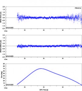
GPS World authors Oliver Montenbruck (German Space Operations Center) and Richard Langley (University of New Brunswick) have written an early analysis of the signals from FM3; this account will appear in the January issue of the magazine. A few selected excerpts from that article, and one figure:
“Anyone with commonly available GNSS receivers can presently access the open signals in the E1, E5a, and E5b frequency bands as well as the wide-band E5 AltBOC signal.
Figure 1: Pseudorange errors of IOV-3 tracking at Tanegashima, Japan, using the E1 BOC(1,1) signal (top) and the E5 AltBOC signal (center). The elevation angle over time is shown in the bottom panel.
“According to an ESA statement, FM3will continue to use binary offset carrier modulation — specifically BOC(1,1) — on the E1 Open Service signals for the time being. In contrast to this, the first pair of IOV satellites has already started to use composite binary offset carrier modulation, which offers better multipath suppression in the received signal.
“The E5 AltBOC pseudorange measurements in particular exhibit an exceptionally low noise and multipath level of better than 10 centimeters at mid- and high-elevation angles.”
After discussing and displaying some carrier-phase measurements of the Galileo FM3 E1, E5, and E6 signals, Montenbruck and Langley conclude; “This level of performance highlights the potential benefit of Galileo signals in advanced triple-frequency techniques such as undifferenced ambiguity resolution and ionospheric monitoring.”
Theoretically, the total of four Galileo IOV satellites now in medium-Earth orbit yield the minimum number needed to perform a 3D navigation fix, although no statement of initial — or even sketchy — operating capability has been issued by the European Space Agency (ESA), nor is one expected.
Antonio Tajani, vice-president of the European Commission (EC) and head of the EC directorate-general responsible for industry and entrepreneurship, continues to publicly maintain a “political objective [of] the delivery of the first services before the end of 2014,” based on 18 orbiting satellites. In a December speech, he revised the basis for that position slightly to say the civil Open Service (OS) could be declared operational with as few as 12 satellites.
The system operators had announced three dual-satellite launches in 2013, two dual-satellite launches and one four-satellite launch in 2014, hypothetically producing an operable constellation of 18 satellites by the end of the promised 2014. However, unconfirmed reports from Europe suggest that problems with manufacture of the next set of 14 Galileo satellites mean that no launches at all will take place until Q4 of 2013. Whether this will push out the service delivery date beyond 2014 or not remains open to conjecture.
Compass
Another matter open to conjecture and much speculation is whether the world will soon — or ever — see an interface control document (ICD) for China’s Compass system. More than a year ago, I wrote that “The ICD has been rumored to be available previously to receiver manufacturers within China, creating some disgruntlement among companies outside the country . . . GPS/Compass chips and receivers are being actively developed by many Chinese manufacturers and research institutes.” Indeed, conference presentations, leading to a published article in this magazine’s October issue, “What Is Achievable with the Current Compass Constellation,“ confirm that this is so.
And yet, the rest of the world neither has nor holds a Compass ICD.
The end-of-year rumor mill has kicked into gear again, though. A GNSS industry representative stationed in Shanghai, China sent this message recently to a U.S. colleague: “Latest unofficial news said that the Compass Interface Control Document (ICD) will be released on 27th this month, and will be available on the internet on 28th.”
At the magazine’s annual Leadership Dinner, held during the ION-GNSS Conference, we gave the first GNSS Leadership Awards to four individuals for their respective work in the four fields of satellites, signals, services, and products. We asked each recipient to give us a vision of the future: upcoming work, whether that’s something they plan to undertake or they think someone else should get going on, new directions for the industry, and so on. I asked them to ruminate as speculatively and as far into the future as they wished to go. Here’s what they told us.
These are not lifetime or career achievement awards, but recognition of significant contribution in the last year or two. Think of them as the Oscars, the Academy Awards of GNSS, if you will, for significant recent achievement.
Several people were nominated in each category by a small group, then voted on by a larger group of about 40, including the magazine’s Editorial Advisory Board, the contributing editors, and a dozen industry executives.
Here are the award recipients, followed by their remarks to an audience of 200 GNSS international VIPs attending the GPS World dinner.
In the Satellitescategory: Martin Unwin and the Surrey Satellite Technology Team
Principal engineer, SSTL.
For work on the GIOVE-A and Galileo IOV satellites, and on space-borne receivers
In the Signalscategory: Todd Humphreys
Director, Radionavigation Laboratory, and assistant professor, University of Texas at Austin.
Leader of several seminal studies on spoofing and jamming; testified this summer before Congress on the subject.
In the Servicescategory: Waldemar Kunysz
Senior staff engineer, NextNav LLC.
Forwork on Wide Area Positioning System (WAPS) design and implementation in the continental United States.
In the Products category: Robert Lutwak
Chief scientist, Symmetricom.
For practical advances to overcome the intrinsic physical barriers to affordable chip-scale atomic clocks, enabling precision time and time transfer in mobile GNSS and communications systems.
Now, their remarks.
Martin Unwin, honoree in the Satellites category.
Martin Unwin
Principal Engineer, Surrey Satellite Technology Team
“I feel privileged and honoured to receive this award from GPS World.
“With respect to the achievements in GIOVE-A and Galileo, I cannot claim this award on behalf of myself, but I will claim it on behalf of the people in SSTL who made the projects possible, and to those in the team here who have been working tirelessly to make the payloads and satellites happen. We are of course partnered with others in Europe that have been labouring equally hard, so it has been a true team effort.
“With respect to the spaceborne GPS and GNSS activities, my achievements have only been possible thanks to the top class staff we have in the receivers team, and thanks are also due to the support we have had from the rest of SSTL.
“In the 20 years I have been in the company, Surrey Satellite Technology Ltd has grown from a small University-based department to a major player in the international space scene, and I am immensely proud to have been part of this story.
“A few words for the future:
“Whilst it cannot quite match the early heady days of GPS, I still think nevertheless we are entering an exciting time in the GNSS world. We have two operational systems, and within a few years, we will be seeing two more reaching operational capability. Dual-, even triple-frequency civil signals will soon become operationally available, and some very wide bandwidth signals will be sent down, in particular, by Galileo. There is bound to be a steep learning curve in understanding how to exploit these new signals, with a few crevasses to be negotiated during the climb. But these new signals are bound to lead to an expanded vista of increased accuracy and robustness, and undoubtedly some unexpected destinations.
“Taking perhaps the highest perspective, spaceborne remote sensing is a good example that has surprising relevance to the rest of us still on the ground. In this case, GNSS satellites are used as radar sources, and all that is required on a low Earth orbiting satellite to change the world is a GNSS receiver. GPS Radio-Occultation measurements from low Earth orbit are now already the third most important data source for our global weather forecasts, thanks to the like of the COSMIC and MetOp satellites. Furthermore a new constellation of satellites called CYGNSS has recently announced by NASA that will be using ocean-reflected GPS signals to probe inside hurricanes and typhoons, and for the first time will enable the sensing of the wide-scale ocean roughness, leading to improved global wind and wave knowledge.
“By adding to this spaceborne receiver the ability to accommodate signals from Glonass, Galileo and Compass, plus any other available GNSS-type signals, the number of measurements is instantly quadrupled, and a new capability in sensing the atmosphere, waves and even ice and land is likely to be seen. Meteorologists already view GPS as an emerging utility for weather and climate sensing, but I think this new role for GNSS will be reinforced and expanded into yet another area where GNSS incontrovertibly, if indirectly, makes such a significant difference to our daily lives.
“As with many other applications where GNSS has become important or even critical to our modern world, this is, at the same time, both a blessing and a matter for some caution.”
Todd Humphreys, honoree in the Signals category. (credit: Mark Cowart)
Todd Humphreys Director, Radionavigation Laboratory,
and Assistant Professor, University of Texas at Austin
“It’s a genuine honor to receive this award. I’d like to thank Alan Cameron and all the contributors to GPS World. GPS World plays an essential role in building our GNSS community and keeping it together, providing GNSS news, instruction, and, indispensably, gossip!
“I’d also like to thank my students at the University of Texas Radionavigation Lab. Much of the credit for this award goes to them
“The futurist Ray Kurzweil spoke at a conference I attended back in 2001. Maybe some of you have heard of Ray. He’s regarded variously as a prophet, or a crackpot. He’s taking hundreds of vitamins every day to keep himself alive until the singularity arrives, at which point he’ll download himself onto a robot and live forever, or at least he’ll have his head cryogenically frozen so that he can be downloaded and live forever later on.
“In that 2001 talk Ray made some bold predictions. One, in particular, I remember well. “Within the decade,” Ray assured us, “we’ll all be wearing special contact lenses that give us a permanent Internet feed directly to our eyeballs.” Nonsense, I thought, and indeed it was nonsense. Here we are in 2012 and no such contact lenses exist, never mind their being in widespread use.
“I resolved back then that if I were ever called on to peer into the future and tell what I see, as Alan has asked me to do tonight, I’d be more modest about it.
“So tonight I’m going to make a modest prediction, and only one of them. I predict that by the GPS World dinner in 2020 carrier-phase differential GNSS, or, if you prefer an adjective for what should be a noun, Real-Time Kinematic, will be cheap and pervasive. We’ll have it on our cell phones and our tablets. There will be app families devoted to decimeter- and centimeter-level accuracy. The consequences will be fantastic. And this will be enormously disruptive to the current precision navigation industry. This will be the commoditization of centimeter-level GNSS.
“Now you may very well object to this prediction. You might point out that integer ambiguities will be difficult to resolve in the face of the near-field effects around and poor placement of the GNSS antenna in handheld units. You might also argue that the increased power requirements of carrier-phase techniques will be a dealbreaker for mobile devices. That’s all fine. I agree that those are hard problems. My students and I are looking into them, trying to overcome them.
“But please don’t make as one of your objections the one that I’ve heard so many times: “Why would anyone ever want cm-accurate positioning in their cell phone?” Because I’ll object that your objection lacks imagination.
“To see one example of what could be done with commoditized centimeter-accurate GNSS, I invite you all to a presentation by my students Daniel Shepard, Ken Pesyna, and Jahshan Bhatti tomorrow in the F5 Session (Millimeter-accurate Augmented Reality Enabled by Carrier-Phase Differential GPS). They’ll show off a crude box that we’ve built, through which, if you peer, you can see a sandcastle that’s not really there. And you can walk around the sandcastle and see it from all sides with centimeter accuracy.
“Imagine when this technology is in our tablets! Or, better yet, when it’s in our glasses — or, I suppose, our contact lenses. Not that I’m making any predictions about contact lenses…”
Waldemar Kunysz, honoree in the Services category. (credit: Mark Cowart)
“Ladies and gentlemen: I am much honored to receive this award and recognition. It means a lot to me.
“I would like to thank people that made difference in my career, without them it would not be possible to be here.
“First I am grateful to Dr. Maurice Meyer, former MIT professor. He taught me the black magic of antenna engineering.
“I am quite sure that his spirit guided me when I invented GPS/GNSS “Pinwheel” antenna when working at Novatel for which I received 6 patents. I also would like to thank Prof. Gerard Lachappelle and Dr. AJ Van Dierendock for teaching me GPS technology and to Dr. Phillip Ward to provide very useful insight to subject of interference. That knowledge saved me countless hours when troubleshooting some system level issues when designing the current and past GPS/GNSS products.
“Currently I am working at, LLC developing a new terrestrial based Wide Area Positioning System (WAPS). NextNav is a start-up company based in Silicon Valley that already, in its short life, has designed a new system that is being deployed in 40 major urban cities in the continental USA. This system will allow receiving a GPS look like signal in the areas where the coverage is weak or non-existent like indoors and dense urban developments (i.e. downtowns, urban canyons, etc.). We have already over 50 beacons installed in the San Francisco area that allows indoor and outdoor positioning anywhere from San Francisco to San Jose.
“As we know all major terrestrial systems have been shut down in the past several years such as Loran, Omega, Decca, etc. We became very dependent on satellite based services such as GPS and Glonass without any terrestrially based back-up. Any major solar storm in future could be very disruptive to this service so having a terrestrial based system that is in sync with satellite based system will fill that void.
“The future looks very bright for the positioning service industry. In my opinion, by 2020 it will become another utility such as phone or power. I’d like to agree with my other awardee and predict that in 2020 we will be able to have a carrier-based positioning accuracy anywhere and anytime available from any devices including handheld units. You will know where all your assets are and you won’t need to post a question to your wife: “ Honey, did you see where my tie is?”, your personal digital assistant will locate it for you.
“Thanks again everyone for being here.”
Robert Lutwak, honoree in the Products category. (credit: Mark Cowart)
Robert Lutwak
Chief Scientist, Symmetricom
“Thank you, Alan, for the introduction. Thank you also to the awards committee and especially to the individual who nominated me.
“Alan requested, repeatedly and forcefully, that we keep the sentimentality to a minimum, but I would be remiss if anyone left here with the impression that the development of the Chip-Scale Atomic Clock was in any way a solo effort.
“On the contrary, while I have had the privilege of being the “front man,” the success of this program can be attributed entirely to the fantastic collaboration between three highly disparate groups, from very different industries and cultures, including our Research Group at Symmetricom’s Technology Realization, in Beverly, Massachusetts, the MEMS group at The Charles Stark Draper Laboratory, led by Mark Mescher and Matt Varghese, and the optoelectronics group at Sandia National Laboratories, led by Darwin Serkland. If any of these groups and people had been anything less than extraordinary, both technically and personally, I would not be standing here this evening.
“With this introduction I can say, with little loss of humility, that the Chip-Scale Atomic Clock is a really cool device. Depending on where you’re coming from, it’s either 100X lower size, weight, and power (SWAP) than traditional atomic clocks or it’s 100X more accurate than quartz oscillators with comparable SWAP. Regardless of your perspective, it clearly represents a disruptive technology and paradigm shift for portable battery-powered navigation, communication, and timing applications. For comparison, the CSAC can run for a day on a full cellphone battery charge whereas the next lowest power clock of comparable performance will run down a car battery in an hour. The CSAC is not an evolutionary improvement in SWAP, it is revolutionary in that it enables previously untenable system architectures, mission scenarios, and network topologies.
“Since Symmetricom introduced the first commercial CSAC, roughly 2 years ago, the market response has been overwhelming. Despite having done our due diligence to predict the market demand and despite having nearly doubled our manufacturing output every quarter, our shipment backlog remains strong and I am frequently surprised by innovative customer applications that we had not envisioned at the product launch. We have to date shipped many thousands of CSACs to over a hundred different customers, representing vastly different markets and applications. While many of the novel applications are still in the early stages of prototype development and evaluation, it is clear that CSACs will be ubiquitous across diverse applications within the decade.
“I am fortunate, in my position, to interact directly with the technical integrators of the CSAC and learn the details of many of the applications. My general impression is that the timing and frequency stability performance of the CSAC is adequate for most of the emerging applications. The most common requests that I hear from customers are for reduced cost, power consumption, and size, in that order. It is not surprising that size is at the bottom of the list — in most applications, the batteries are still larger and heavier than the CSAC, so small improvements in power consumption are generally more valuable to reducing system SWAP than size reduction of the CSAC itself. As in any new technology, the cost will come down naturally with increased volume and improved manufacturing efficiencies, both at Symmetricom and at our vendors. While it is unlikely that you will get a CSAC in your next free cellphone, I do expect that the cost will progressively decrease over the next several years and the technology will become cost-viable to an exponentially increasing spectrum of applications. Similarly, we continue to evolve our electronics and algorithms for improved power consumption, aided by external advancements in microwave and microprocessor electronics driven by the smart-phone industry. It is my expectation that a factor of 2X improvement in power consumption is likely within the next three- to five-years.
“To date, most of the commercial products that have emerged, based on CSAC technology, have been in the timing and frequency calibration space. It is not surprising to me that the time and frequency community was the first to adopt and exploit the technology as many of them have been closely monitoring the development program and had the internal expertise and experience to rapidly exploit it.
“I admit, though, that I am a bit disappointed to see that there are no papers with “CSAC” in their titles at the 2012 ION-GNSS, but I am confident that this will change in the years to come. Adoption of CSAC by the navigation community has lagged behind the timing community in large part, I believe, because the technology has caught the community somewhat off-guard and the benefits of the CSAC to INS and GNSS are just now beginning to be realized.
“The most obvious and straightforward application of CSAC to GNSS is rapid P(Y) acquisition and we have demonstrated 15s time-to-subsequent-fix (TTSF) after two hours of GPS denial. This was a fairly simple demonstration that simply consisted of jamming time into an unmodified GPS receiver, but I believe that this is just the tip of the iceberg. With access to the core navigation algorithms within the receiver, precise knowledge of time could improve the receiver performance and reliability on other levels, including (at least):
Improved uncertainty of the navigation solution
Navigation with less than four (or less than three) satellites
Anti-spoof and anti-jam detection
Seamless co-integration of GNSS and INS systems
“Another navigation area that I believe is ripe to benefit from CSAC technology is in self-assembling navigation systems, e.g. a local ad hoc GNSS-like network which self-assembles from handheld timing beacons/receivers. Such a system would have value for safety-of-life applications in GPS-denied environments, such as indoor firefighting and mine safety.
“Thank you again for the recognition and opportunity of this award.”
The 2007 action film of that name concerns a domestic criminal plot, disguised as a terrorist attack upon U.S. infrastructure: an Internet-based hack into Federal Bureau of Investigation computers, the transportation infrastructure, the stock market, national video broadcast channels, the utility power grid, the National Security Agency, and the Department of Defense nerve center. One of the film’s two heroes recognizes this as a fire sale, an attack upon the nation’s computer controls, an attack in which “everything must go.”
Inspiration for the film came from a 1997 article in Wired magazine, “A Farewell to Arms,” written by John Carlin. “For those on the ramparts of the world’s sole superpower, the digital winds are blowing an icy chill through the triumphant glow of the post-Cold War,” the article begins. “Suddenly, the satellites over North America all go blind . . .” it envisions in mid-stride.
As prescient as the 1997 article is, and as slam-bang inclusive of almost every bit of taken-for-granted infrastructure as the 2007 actioner tries to be, neither one mentions GPS. There’s no reason why they couldn’t — they just didn’t. We can remedy that right now, with the following imagined scenario.
The placid mood of a lazy spring afternoon shatters at 4:53 p.m. Mountain Standard Time when the GPS constellation goes offline worldwide.
Long reliant on GPS timing for load management, electrical grids begin to move out of synch. A minor problem in a southern Illinois sub-station quickly morphs into a cascading power outage that plunges the North American continent into darkness.
The Pentagon command center detects a massive distributed denial of service attack underway on key areas of American military, utility, and aviation infrastructures. Air traffic flow systems are paralyzed, followed by train controls. Cellular networks collapse. Automatic cash machines and banking networks quickly roll down their shutters. All depended on GPS for positioning, navigation, timing, or all three; they simply cannot function without. Backups, long discussed but never deployed, can’t help.
Computerized transfer of information grinds to a halt nationwide. Mayhem ensues. Riots break out in large cities. Police forces join the ranks of the newly crippled, and are forced to deal with unrest in the old-fashioned way: going out into the streets on foot.
As a once-beautiful day descends into long dark night, confusion, desperation, and fear spread black wings across the world.
The information has been lost.
Doomsday scenarios go in and out of fashion. Lately they’re all the rage. I was startled by an April article in Smithsonian that led to my May editorial “That’s Denial.” But now I’m noticing these portents more and more.
Every benefit brings its own drawback, every strength its own weakness. The principle applies not only to technology, but to every branch of human endeavor, of the natural adaptive world, even to the laws of physics. We little realize how totally reliant our civilization has become on very precise information. Without backups, defenses, mitigation, and safeguards, even a momentary loss of information can wreak catastrophic effects. Witness the recent Facebook Fumble, described by Chuck Shue of UrsaNav at the ION PLANS meeting:
“On May 18, 2012 the ripple effect of two (2) extra milliseconds of delay required to calculate the opening price during the Facebook initial public stock offering produced damages to Facebook estimated from $40 million to $400 million — for one stock. Although not as widely known, Nanex reported that the timing glitch, probably from errors in routing software, also affected Apple, Intuit, Netflix, QualComm, Zynga, and other stocks.
“What if this were the result of time spoofing, rather than simply a programming error?” he asked.
This is the demonstrated effect of an accidental 2-millisecond delay, in one market of one sector of the national economy. In the case of a prolonged outage, a sustained attack by spoofing, jamming or other means, on the neural center of national infrastructure — that is, GPS — the mind staggers.
We live by lightning-quick transmission and exchange of data. We may just die by it. The cloud touted as the ultimate warehouse, routing center, and solution to business challenges may dump acid rain on our picnic one day.
Our world is driven by information flow in ways unfathomed just a few years ago — and don’t we love it? The technological and societal changes associated with computers, the Internet, Information-Age thinking, and all our neo-survival tools still manage to leave us extremely exposed.
Benjamin Wash, who originated the GPS doomsday scenario at the beginning and many other thoughts throughout this column, wrote “The data sea upon which we sail grows exponentially vaster, and ever more complex and vulnerable, by the day. Our reliance on and need to gain information advantage intensifies as the world becomes more digitally integrated and competitive. Resource competition among nations is fierce, and those who control information exercise control over resources to a greater extent than in any time in our history.
“Information access, flow, and aggregation enable the achievement of strategic and tactical advantage, but also the potential for mayhem. As an entity and as individuals, we cannot afford to be blind to this paradigm-altering reality: information drives the world.”
Our correspondent had more to say concerning the Congressional melee — only be sure to call it, please, negotiation — over the defense budget. GPS, although not perceived by most to be at the center of this, does actually occupy that critical, key position because of the way it coordinates everything else.
The proliferation of sophisticated electronic weaponry and technologies such as GPS jammers and spoofers, empirically evidenced in two articles in this issue, “Drone Hack” and “Going Up Against Time,” show just how vulnerable our golden standard is — and how saliently that vulnerability has emerged — in this information-based era.
The GPS constellation and its associated signals are the primary source of PNT information, which increasingly drives all other information domains in the nation, not to mention for our overseas combatants and coalition allies. Over the coming decades, rapid technological advances will further remake whole sectors of the national infrastructure and national security.
These improvements are contingent upon steady resource allocation within the Air Force. Future on-orbit systems, such as GPS III and its associated capability improvements, are under extreme budgetary pressure for their high cost. Some improved capabilities have already been shelved due to budget constraints, and more may follow. Key among these are strengthened defense of the system; only a few steps have been envisioned, and fewer taken. Many more mitigations, defenses, and backups must emerge from conceptualization into design, testing, and deployment.
Technology’s complexity makes buy-in by policy makers difficult. Technical advances, both achieved and anticipated, are hard to defend in the budget battles on the Hill. But that’s our job, so step up.
Let’s return briefly to the Carlin article. “For all the bustle, there’s no clear direction. For all the heat, there isn’t a great deal of light. For all the talk about new threats, there’s a reflexive grasp for old responses — what was good enough to beat the Soviet Union and Saddam Hussein will be good enough to beat a bunch of hackers. Smarter hardware, says the Pentagon. Bigger ears, says the NSA. Better files, says the FBI.”
Has anything changed since those words were written in 1997? Hardly.
There are no easy answers in the coming knife fights over the defense budget. Vital technologies will vanish under the flailing and battledust of political striving for personal and party advantage.
Decision makers must understand that information systems are the backbone of all we do — and that GPS drives more and more of those information technologies, through its micro-precise electronic timing.
It’s our job to educate lawmakers and beancounters. A letter to your three Congresspeople is a simple yet effective educational tool.
Two British technologists backed by the U.K. Ministry of Defense have filed patents on the future interoperable GPS and Galileo signal designs that severely disrupt modernization plans for both systems and suddenly, unexpectedly place receiver manufacturers in a highly uncertain and unfavorable situation. Some of the patents have been granted in the U.K. and in Europe, and applications are pending in U.S. patent court, with a ruling expected at any time.
Companies in the United States and outside the country are being approached and asked to pay royalties, on the basis of the patent filings, for use of the European E1 Open Service signal and the modernized GPS L1C signal. Should such initiatives prevail, costs would presumably be passed along to end users of GPS and Galileo — the same taxpayers who have already paid once for the systems.
The purveyor of the royalty solicitations is Jim Ashe, vice president for sales and intellectual property at Ploughshare Innovations Ltd., Hampshire, UK. The patents, if successfully used to collect fees from satellite manufacturers or receiver manufacturers, would have a chilling effect on the use of the new interoperable signals that all parties have labored so hard, for so long, to design. They could quite possibly lead to a return to a BOC(1,1) structure for these signals, losing the benefits of MBOC.
“There’s quite an argument going on,” said one person familiar with the controversy. “Some of the methods of arguing have not been too kind.”
The Background. A great deal of work was accomplished cooperatively between the United States and the European Union (EU) to develop the landmark 2004 signal agreement that emerged from the Galileo Signal Task Force, formalizing cooperation on satellite navigation between the United States and more than two dozen European countries, including the U.K. Part of that agreement concerned a common signal structure (spectrum) for the civilian signals for both the E1 Open Service (OS) signal — the Galileo equivalent of GPS L1 — and the new U.S. GPS L1C signal to be implemented on the GPS III satellites, coming as early as 2015.
The EU said during that process, in effect, “Even though we have agreed on this, Europe wants to be able to optimize the E1 OS signal beyond the agreement on that civilian signal being a binary offset carrier BOC(1,1) signal.” Both international entities had agreed that would be the waveform or the spectrum of the new signal.
The Europeans began to evaluate methods of optimizing their signal. They had some designs called composite binary coded symbols (CBCS), a mechanism of putting a higher frequency componenent into the signal structure, and also a version called CBCS*, meaning that they found there was a bias generated by that extra signal, and so they had to invert every other one of its repetitions.
The signal structure that they were playing with was centered on a plus and a minus 5-MHz component. (Actually five times 1.023, because of the inherent clock of GPS, you can think of it as 1.023 MHz. Everyone in doing compatible or interoperable signals agreed upon that; when reference is made to 5 or 10 MHz, or an even 5 or an even 10, it means that number multiplied by 1.023).
The Europeans were were putting an additional BOC signal on top of the BOC 1,1, and it would have plus or minus 5 MHz as the centers of those two BOC peaks, and then some kind of waveform to modulate that.
The United States pushed back against that to some degree, and proposed adoption of the so-called MBOC waveform, in which case the U.S. signal was equally optimized with a concept called time-multiplexed BOC (TMBOC). The Europeans used the CBOC approach. So, very different ways of doing this. In the European way, they transmitted a continuous but very low-power BOC(6,1) term. The U.S approach transmits four BOC(6,1) chips out of every 33 chips of code (see “Future Wave” sidebar).
A chip in this case means a part of the spreading code, so each signal has its spreading codes, just like the C/A code is a spreading code, meaning a pseudorandom code modulating the carrier. L1C and E1 OS have a pseudorandom spreading code.
The U.S. approach does not put BOC(6,1) components onto the data; that’s what is commonly called MBOC. The U.S. approach is TMBOC, on the pilot carrier only, not on the data component. The European system is like two separate signals, the BOC(1,1) signal having both pilot and data, and a BOC(6,1) signal having both pilot and data. They’ve put the (6,1) into both data and pilot components.
Cue the Antagonists. Part of the task force from Europe and the United States considering the future signals’ make-up were Tony Pratt and John Owen, who works for the U.K. Ministry of Defense and whose office sponsored Pratt’s work. The two participated heavily in all these signal discussions. They stated in early meetings they planned to file patents in some areas.
“Frankly,” states one source, “people should have paid more attention when they said that, and asked ‘What do you mean, and how’s it going to work, etcetera?’ And secondly, there probably should have been a written agreement between parties that nobody will take advantage or patent any of these ideas that we are developing.”
Pratt and Owen filed a number of patents domestically, in the U.K., and and in the European Union, in 2003 and in 2006, and in other places around the world, such as Japan, Canada, and in the United States as well. Some of the U.K. and European patents have been granted. The first of some of those U.S. patents may be issued in the near future.
The original patent filings were later amended to include new claims. The new claims were much more specifically oriented toward TMBOC and CBOC, whereas the original claims were more generally oriented toward modulated methods. The claims have been modified over the years; this is fairly standard patent practice.
As a result, the original 2003 patent doesn’t necessarily read on a particular signal, but its early filing date has precedence. The claims have been updated and modified, and if the patent office issues those, as a true patent, then the new claims apply. Plenty of big patent battles have been fought over just such issues.
Once the patent is issued, a satellite or receiver manufacturer must assume that it is valid, and has only two responses to make, other than acquiescing to royalty claims. The manufacturer can either say, if building a product, “No, my product does not infringe, and I will prove that it doesn’t.’” The other choice for manufacturers is to go back into the patent office and sue the patent filer (and grantee) in the patent courts and prove that the patent was invalid in the first place that the patentee should not have been granted it.
The United States and others were taken off-guard when the U.K. company Ploughshare, which is owned and controlled by a part of the British MoD called Defense Science and Technology Laboratory (DSTL), started making claims on manufacturers. The DSTL is similar to the U.S. Defense Advance Research Products Agency (DARPA), which is credited with inventing the Internet. If taxpayer money goes into something new and interesting, it is considered in some circles legitimate to file patents on those and attempt to recover taxpayer money through royalties on that taxpayer investment. That concept is not being challenged. Questions as to whether the patents are legitimate are very much in discussion.
Ploughshare has contacted companies, saying, “If you use these signals coming from either the European satellites or the U.S. satellites, we will go after companies using these signals.” There are different patents issued, one by the European Patent Office, applying to most of the EU countries, that applies directly to the TMBOC signal, the E1 OS signal, and possibly also to Europe’s E5 signal, which is E5a and E5b; and there is also a patent for GPS III, the L1C signal.
“If you take the patent that hits TMBOC, and you take the broadest possible interpretation of that patent against receiver companies, it says: if you bring into your antenna and process that signal, whether you use all parts of it or not, for instance if you use the BOC(1,1) and not the BOC(6,1) part — then you infringe the patent. Others argue that if you don’t use both components, you don’t infringe.
“But the claim is written broadly enough that it would apply to any receiver receiving and processing the signal. Nobody says what processing means. The patent says if you receive and process the TMBOC signal, as defined in the prior claim, you infringe the patent.
“There is confusion as to whether that will apply or not apply — some people expect that it doesn’t and some people think that it might. That’s up in the air.”
George Is Getting Upset. Various factions in the United States are upset by and trying to figure out what to do about the impasse. From a government point of view, there are three paths that the U.S. government can follow:
Put pressure on the U.K. diplomatically. That would be up to the State Department to put pressure on the EU or the U.K. in particular. The EU and the continental Europeans are equally furious at the British for doing this, as far as parties in the U.S. understand. This can’t be stated as a fact but is widely understood and thought to be the case. The diplomatic approach has its limits, obviously.
Go into Europe and fight the patents in European patent court and try to prove them invalid, to invalidate the patents. Companies could do the same thing, go into various courts, whether they be U.S. or European or Japanese, and say: “Our receivers don’t infringe,” and then have to prove that to the court; or say “The whole patent should not have been allowed, and I’ll fight the legitimacy of the patent.”
Some believe — and there is controversy and anger on this point — that, just as Galileo’s IOV satellites have the capability to transmit without the BOC(6,1) component, the United States should be able to do that with the GPS III satellites as well. Because if the signal is not there, and if the receivers are therefore not designed to process the signals that are not there, then the patent no longer has any relevance.
“If we are to turn off the BOC(6,1) term for a period of time until the legal or diplomatic or other approaches worked, then we would be able to turn the BOC(6,10) term back on again, and return to the original agreed MBOC and TMBOC signals. That requires some coordination between the United States and Europe, and it requires some work to make that possible in the GPS III satellites, putting a switch in the GPS III satellites to permit the operators to turn that (6,1)BOC on and off. This is being hotly debated.”
Some parties object, stating that L1C is too important a signal to mess with, and this proposal runs the risk of slowing down the program, and/or making it more expensive. They believe strongly that the off/on switch is not the best or most far-sighted option: why should the United States be forced to change its signal design due to an illegitimate patent, and in the end wind up with a less capable system?
It is not publicly known whether the Air Force is or is not looking into that option.
During the week of June 25 there was Working Group-A meeting in Washington D.C. followed by a plenary meeting between the EU and United States. The patent controversy was presumably discussed in some fashion, but whether formally addressed or lurking in the background is unknown at this time.
“There is some naivete around this,” said the magazine’s soure. “It’s a serious threat. People think maybe they’ll only go after the high-end receivers, and maybe the royalties won’t be so bad. Ploughshare is trying to lull people into a false sense of security. The impact of this will be great unless it is defeated.”
“The L1C waveform originally was to have been a pure BOC(1,1) (a 1.023 MHz square wave modulated by a 1.023 MHz spreading code). Negotiations between the U.S. and the European Union (EU) at that time resulted in an agreement that both GPS and Galileo would use a baseline BOC(1,1) signal. However, the EU reserved the right to further optimize their signal within certain bounds. Some of the optimization proposals were known as CBCS and CBCS*. However, in further EU/US discussions it was decided that L1C and the Galileo E1 open service signal should have identically the same spectrum. This was a significant challenge because of different baseline signal structures and existing designs.
“The breakthrough came when [U.S. representative] John Betz proposed what is called MBOC. The MBOC waveform has 10/11th of its power in BOC(1,1) and 1/11th in BOC(6,1). However, L1C and E1 OS achieve this result in very different ways. The Galileo technique is called CBOC. The GPS technique is called TMBOC. Whereas Galileo has a 50/50 power split between pilot and data and includes the BOC(6,1) component in each, GPS includes the BOC(6,1) waveform only in the pilot component by modulating four of every 33 spreading code chips with a 6 MHz square wave and 31 chips with a 1 MHz square wave. With 75 percent of the power in the pilot, the result is 3/4 x 4/33 or 1/11, as required. It is likely the BOC(6,1) signal component will be ignored by consumer-grade GNSS receivers where a narrow RF bandwidth is preferred. Fortunately that is a loss of only 12 percent (0.56 dB) of the L1C pilot power. However, for commercial and professional grade receivers, the extra waveform transitions (wider Gabor bandwidth) can be used to improve code tracking signal-to-noise ratio, and with certain advanced techniques it should be possible to improve multipath mitigation. This final point depends on careful control or calibration of the transmitted code timing and symmetry.”
This month we present a guest column by James D. Litton, who attended the 2012 GPS Partnership Council, jointly sponsored by the Armed Forces Communication and Electronics Association and the U.S. Air Force GPS Directorate. The key topic of this year’s council quickly emerged as the tension between commercial off-the-shelf GPS receivers and official military issue; the two are used side-by-side in active military theaters.
By James D. Litton
This year’s GPS Partnership Council provided among other highlights a discussion of the tensions between commercial off-the-shelf (COTS) receiver systems used in tactical combat operations versus official military GPS user equipment (MGUE), and an enthralling warfighters’ panel that revealed much of those COTS/MGUE dilemmas. The event, held May 1–2 in El Segundo, California, drew an enthusiastic and involved audience, including many GPS veterans. I was struck by the graying of the clan as well as the practiced and confident presentations of current civilian and military program staffs.
Keynote speaker Brig Gen Martin Whelan, Director of Requirements, Headquarters Air Force Space Command, emphasized that ideas for improvement of the system would be hard sells under current budget realities, but good ideas for lower cost would be welcome. Referring to the three segments — space, ground, and user — he recommended that the segments should talk with each other and challenge requirements. In effect, he implied that the separate segments could reduce overall costs, rationalize requirements, and cooperate better in optimizing the resilience and flexibility of the system, including — this is my interpretation — taking advantage of the “competitive” GNSSs to effect user satisfaction.
According to Whelan, resiliency of the space segment is a top priority; smaller satellites, hosted payloads, and net-centric designs were highlighted. He commented that multiple GNSSs should be employed in such a way that the user does not know the difference.
Regarding the upcoming budget, he told us that Department of Defense will be cut by 22 percent, the Air Force will drop 9 percent — but the AF space budget only 1.5 percent. A notable exception to the generally favorable overview was his comment that the MGUE segment, from a distance, looked uncoordinated. Much more along this line came up later during both days of the Council.
Widespread COTS. There was an air of defensiveness about the user segment, and many comments on both the success and the risks associated with the widespread use of COTS user equipment. We heard further commentary on the very infrequent use of SAASM keys, due to the difficulty of procedures to obtain and employ them, and due to the perception of very low risk of jamming and spoofing threats in current combat deployments.
A session on “The Future Military Receiver” enlisted two panels of government experts and contractors from Deere-NavCom, Garmin, IEC, Johns Hopkins Applied Physics Labs, Raytheon, and Rockwell-Collins. Although the unclassified nature of the presentations limited the level of detail, it clearly emerged that many tactical, in-combat deployments of COTS GPS receiver systems had occurred and continue to occur.
A video compared the jamming resistance of a Garmin receiver with that of approved GPS User equipment receivers. It showed a screen of the Garmin receiver losing satellites at greater distances from the jammer and losing lock at closer distances. Directorate employees and officers made several references to the risks from dependence upon COTS receivers, and related with considerable candor the difficulties with large, expensive, power-hungry MGUE, both mobile and platform-mounted, models of which were held up during the presentations — often to laughter from some in the audience.
More on this followed in Day Two’s dramatic warfighters’ panel, which many people felt was by itself worth the price of admission. These experienced users of GPS under fire — from Coast Guard search and rescue to Air Force forward controllers calling in air strikes within range of small-arms fire — related direct personal experience in a broad array of critical applications. They clearly knew how to use COTS equipment to good advantage and described the operational protocols developed from hard and sometimes painful experience.
Manipulation of multiple screens in a heavy device, which requires initialization or synchronization before dismounting, was often simply not an option. Translation of such experience into qualified requirements is a major challenge for the Air Force and Army. Overdependence on the anecdotal but very valid combat experiences would weaken a design against an enemy with even rudimentary jamming and spoofing capability.
An astute questioner asked “Have you seen any evidence that the enemy (in Afghanistan) has changed tactics because of our technology?”
The answer came “Not yet,” with a comment that the enemy’s early warning systems are very sophisticated and the target of a mission to capture a high-value individual (HVI) frequently knows that such a mission is underway; his support network spirits him away and attacks the mission with the advantage of surprise denied to our forces, abetted by the advantage of favorable terrain and numbers accruing to the enemy.
The Puck. The Army-led MGUE program status was described as being at technology readiness level (TRL) 6.0; the request for proposals was released on April 16. The key to the success across platforms of this “system of systems” was said to be the Common GPS Module (CGM), also referred to as the Puck. This module is M, P, and C/A code-capable and SAASM-capable but has flexible interfaces and “emulates commercial.” The module itself is a system-on-chip (SoC) that can be integrated across many platforms. Depending upon the level of integration employed, it can be as small as chips found in smartphones or somewhat larger.
The program schedule was defended as having only been funded two years ago and having very complex security and platform interfaces. This program presentation drew a large number of questions and commentary from the audience, much of it politely skeptical and showing impatience with the bureaucratic aspects of the program. Well-informed former military field-grade officers in the audience questioned its real availability. The answer that it would be available in quantity sometime in 2017 did not please the questioners.
In short, procurement regulations appeared to be the highest barrier to a rapid, flexible program for a net-centric, open-architecture system development.
Currently, the circuit boards for the MGUE are classified secret, but it is hoped to have these at a confidential or unclassified level for deployment by handling the encryption exclusively in software. The leader of this presentation indicated that software receivers were the ideal but were not available, so reduction in size, power consumption, and complexity in hardware was the goal.
Trumping Military. One almost nostalgic comment hearkened back to the time when military systems were regarded as the height of technological excellence, whereas it is now generally perceived that commercial systems trump the military in sophistication. Garmin claimed to have developed SAASM receivers in the lab but found little interest from business leaders at that time.
The CEO of Mayflower Communications, which makes and sells miniaturized SAASM receivers, pointed out that anybody could make a SAASM receiver employing a Sandia crypto-chip approved by the U.S. National Security Agency (NSA) but pointed out, as did several others, that the availability of certifications and authorizations was very limited, and that volume drove cost. Implicitly, NSA’s requirements and protocols got blamed for the limited distribution and use of SAASM receivers.
Day Two
The second day of the GPS Partnership Council comprised The Nation and The Warfighter. In the latter group came an outline of the Army’s COTS vision and — the hit of the entire conference — the Warfighter panel with a keynote introduction by a USAF colonel warrior now at the GPS Directorate.
The Nation. Tony Russo, director of the National Coordination Office for Space-Based Positioning, Navigation, and Timing, disabused those who thought that the apparent demise of the LightSquared threat had eliminated that subject from his agendas; he still deals with it often. He provided entertaining and informative examples of non-obvious and valuable applications of GPS, from assessing rugby players’ game performance through detection of clandestine underground nuclear tests to a social application of matching available part-time and temporary workers with jobs when labor demand surges and a roster shows where the closest qualified candidates are.
John Merrill of the Department of Homeland Security (DHS) identified 18 critical infrastructures that depend upon GPS integrity and showed the cascading effect of taking out sites like SCADA (Supervisory Control and Data Acquisition) systems. He related a threat-illustrative story of a DHS agent who required constant contact via his agency smart phone but who could not get reception while attending mass in church. The pastor later and very proudly showed him the mobile phone jammer in the sacristy; he had given up on asking parishioners to turn off their cell phones off during services.
James Miller of the National Aeronautics and Space administration noted that only 5 percent of space missions lie outside the GPS coverage envelope (3,000 kilometers to geostationary altitude of 35,800 kilometers is the space service volume). Reducing the burden on spacecraft tracking networks is a highly profitable application for GPS.
Warfighters Panel. These real-life experiences from combat and other vital operations could easily justify an entire article of their own. The following examples will illustrate the life-saving force multiplication of GPS, particularly the ubiquitous civil GPS technology in the current combat environment.
• An Air Force Special Operations Major described a mission to snatch an HVI, giving great detail on battlefield terrain, combat conditions, and how he worked between a COTS GPS receiver and a COTS handheld computer with Google Earth-like facilities to bring JDAMs (GPS-equipped smart munitions) onto an ambush mounted by defenders of the HVI, who were alerted to the raid by their extensive and sophisticated early-warning network consisting of sympathizers with cell phones. His description of the heroics of individual forward controllers, their injuries and fatalities, and the symbiosis of man and machine in a relatively benign electromagnetic interference but relatively malign electromagnetic propagation environment, and overtly and covertly hostile indigenous population, was dramatic and compelling.
Clearly, unsophisticated and easily-available high-power jammers rapidly alter such situations to reduce our technological advantages. Also clear was the need to design user equipment, not just to reject interference but to minimize time and the inevitable ambiguities in actual combat situations.
• A Coast Guard lieutenant described the search-and-rescue missions he flies out of local airports to Pacific Ocean sites. Again, COTS equipment, aided by the near-ubiquity of commercial GPS equipment, along with VHF marine radio on boats and ships, enhances these mission results over those flown with standard USCG-issued navigation equipment.
• An Air Force tanker pilot major now attached to the GPS Directorate described three personal experiences. He once had to ask his boom operator to retrieve the Garmin receiver issued in the survival kit in order to navigate the tanker for rendezvous with tactical aircraft needing fuel when the tanker’s standard equipment failed.
When tasked to fly into an airport in Afghanistan with unreliable navaids, under suddenly occurring zero-zero conditions, the onboard GPS enabled him to land safely.
In a third instance in Iraq, he observed a downed airman being approached by gunmen. The gunmen with AK-47s were being targeted by drone operators. The major was able to discern that these gunmen were friendly forces moving to rescue the downed airman and avert a friendly-fire disaster. The downed airman’s ability to send his exact coordinates were key to the ability of the observer to get close enough to direct rescue efforts and to avoid a fatal error.
• A Navy surface warfare lieutenant commander and a CWO Riverine or small boat skipper cited instances in which GPS was essential to missions and ways in which user equipment design could improve their operations — for example, by making it float.
All the veterans repeated, during or after their accounts of ways in which GPS saved lives or enabled missions, “thank you for what you do,” addressed to the audience, the presenters, and their leaders. Going into denied territory places a high premium on user friendliness, battery life, robustness, size, and weight. In the future, inevitably, jam and spoof resistance will be an object of gratitude, as well.
Final Review. We all know these things, intuitively and by doctrine, but hearing reports from people in harm’s way or retrieving comrades from harm’s way was a great addition to the usual program and technology descriptions by the development teams.
I was particularly impressed with the very articulate, sophisticated, and focused presentations of these combat veterans. It is highly incumbent on the industry and the government GNSS leaders to translate these experiences into design requirements quickly, so that future systems are less dependent on individual ingenuity and on commercial gap-fillers.
Much of this progress depends on truly incorporating the applications focus of commercial product development and on use of other GNSS systems for robustness, flexibility, and affordability — often quoted as mission goals by the leaders of this enterprise.
GDANSK, POLAND — Poland has emerged as a regional leader for Eastern Europe. Among all European countries, it ranks fourth in population and ninth in the size of its national economy. This year, the European Navigation Conference (ENC), which rotates each year to a different host country, has convened in Gdansk, Poland — its first time in Eastern Europe.
Gard Ueland, president/CEO for Kongsberg Seatex and the chairman of Galileo Services, opened his keynote address at the 2012 European Navigation Conference with the statement “GNSS applications and services are the best growth opportunity for Europe.”
Was anyone from the European Space Agency (ESA) or the European Union’s GNSS Supervisory Agency (GSA) listening? They were not, because neither body bothered to attend this ENC — the first time I can recall either organization absenting themselves from this important, top-level technical conference. ESA and GSA presented themselves in significant numbers and seniority at the Munich SatNav Summit in March, on the stage and in the audience. But then money, influence, and visibility (they may all amount to the same thing) are more in circulation at Munich. The ENC merely gathers the researchers and application developers who are doing the real work that will eventually field users and grow markets.
Ueland of Galileo Services was careful to differentiate his topic as separate from satellite-system development per se. He focused on developing applications, the downstream segment that will lead, he said, to new business activities, jobs and wealth creation, and a bigger GNSS market share.
According to a GSA study completed in 2011, the 2010 global GNSS market was 130 billion euros, and of that amount, the European market share in the GNSS sector was 20 percent. “A little bit less than what Europe is used to,” Ueland remarked; that accustomed share is 1/3 of the market. Naturally, Ueland called for further public-sector investment in satnav R&D, which has been the rallying cry of Galileo Services.
In 2020, global GNSS market is estimated to reach 240 billion euros. “Europe will be challenged even to maintain its current share of 20 percent. If we were to succeed in reclaiming the 1/3 share, it would translate into 400,000 jobs in Europe. This is something that Europe needs.”
A position paper, “Satellite Navigation Applications,” goes into further details and is available at www.Galileo-services.org.
Ueland concluded that at the EU level there is a need for a dedicated budget line within Horizon 2020 for GNSS application R&D.
In subsequent talks at the ENC plenary session, Prof. Janusz Zielinski of the Space Research Center of the Polish Academy of Sciences discussed Polish activity in EGNOS and the Galileo program.
Dr. Heidi Kuusniemi of the Finnish Geodetic Institute gave a presentation on the effects of GNSS Jammers on consumer-grade satnav receivers, showing the initial results from research started this year. Jammers, though illegal in most countries, are gaining popularity for financial reasons, to avoid road tolling and insurance billing, as well as personal privacy reasons, to avoid tracking and location-based monitoring.
The Finnish Geodetic Institute analyzed the effects of a $130 L2 and L5 jammer and a $14 L1 jammer on two ublox and two Fastrax consumer-grade reciever, a receiver found inside a Nokia smartphone, and a high-precision professional-grade NovAtel OEM4 L1/L2 receiver.
Horizontal errors up to 130 meters were observed on the consumer grade receivers, and availability decreased to 16 percent in 24 hours. Effects on the one combined GPS/GLONASS consyumer receiver, from Fastrax, were not as pronounced as on the other consumer-grade receivers. In the professional case, accuracy was degraded up to 80 meters, and availability decreased to around 26 percent over 24 hours.
After outlining some jamming detection and mitigation solutions, Kuusniemi concluded that in-car jammers are a serious threat, and steps must be taken against the use of jammers. Future GNSS will have improved resistance to interference, for several reasons.
Davide Margaria of the Institute Superiore Mario Bella (NavSAS group) presented on research regarding “Acquisition and Tracking of Galileo IOV E5 signals,” which are important for the safety-of-life service planned by Galileo.
The Galileo satellite system currently consists of GIOVE-A and B, the two experimental satellites dating from 2005 and 2008, and the two in-orbit validation (IOV) satellites launched in November 2011, the Proto-Flight Model (PFM), and the Flight Model 2 (FM2).
The FM2 satellite has started transmitting E5 navigation signals in recent weeks. E5 is an alternative binary offset carrier: AltBOC(15,10) modulated signal, multiplexing 4 channels in two adjacent sidebands, E5a and E5b: two data channels and two pilot channels. Each sideband can be separately demodulated as a QPSK-like signal.
Using a flexible experimental E5a/E5b COTS front end, NavSAS researchers separately received each sideband, with IF samples transferred for real-time processing, and stored for post-processing. Signals were acquired and tracked for multiple satellite passes of all four satellites.
In an analysis of the E5b signals, both data and pilot channels, they found estimated C/N0 values to be consistent with the satellite elevation patterns and with expected values from the Galileo ICD specifications.
The PFM and FM2 signals were received at approximately 3 dB stronger than the GIOVE-A and B signals. The team further found the presence of secondary code chips and successfully decoded the I/NAC navigation message on the data channels. Their future activities include checking the F/NAV data pages transmitted on the E5a band, and setup of a wideband experimental front-end for coherent E5 processing.
In technical sessions on the first afternoon, I found the following presentations of salient interest.
Byung Hyun Lee from Konkuk University in Korea presented “Performance Analysis of Doppler-Aided GPS/QZSS Precise Positioning for Land Vehicles,” designed for which-lane positioning in urban environments. Using Doppler measurements to compensate for restrictions of carrier-phase measurements, traditional RTK techniques, for precise positioning. Needed for this application are reliable single-epoch measurements and velocity estimation. Double-differenced Doppler measurements yield this quality enhancement.
Using NovAtel FlexPack 6 equipment for rover and reference station, the author and colleagues found sufficient accuracy results with GPS-only in a relatively benign environment, with an HDOP of 1.505 and 7 available satellites. In a difficult or “bad” environment, GPS –only had a HDOP of 6.84 and insufficient accuracy for the which-lane requirement.
However, using GPS and QZSS in the same “bad” situation brought an HDOP of 1.564 and sufficient accuracy for lane-specific car navigation.
Pawel Kicman of the Warsaw University of Technology presented the TALOS Navigation Research Electric Car using COTS components. The vehicle was developed for land-border surveillance using one autonomous robot to monitor industrial perimeters, and a second robot to intercept intruders. The adapted golf cart has a suite of installed sensors: satellite (NovAtel SPAN for GPS/GLONASS integrated with tactical grade IMU), inertial (low-grade IMUs), magnetic, visual (cameras and laser rangefinders), and odometric.
The researchers, including a student team, obtained sufficient accuracy for the application, provided hands-on experience, and offers many prospective research projects, leading to development of autonomous driving on the vehicle, since all the sensors and control capabilities are there.
Robert d’Aystetten from Sprint in Poland (the company is not the same nor is it a subsidiary of the U.W. wireless carrier Sprint) described an eco-driving algorithm for fleet applications to promote safe and efficient driving habits, using car-tracking data from a number of sensors to construct a driver’s profile and detect “overlimits.” The application assigns motivational points to every driver in the company (it has a fleet of nearly 500 vehicles) for eco-driving — efficient acceleration, braking, and cornering — speed, and generated alerts. In addition to maintaining and improving organizational driving standards, the data can be used by insurance companies to prepare better insurance offers based on actual profiles and driver performance.
The VIZAN SOFIT tracking device employs real-time GPS tracking and positioning; GPRS location data transfer to the server; smart algorithm of data acquisition (time, distance and angle based); acceleration detection (e.g. in case of sudden braking); speed measurement; internal memory for location data storing in case of GSM signal loss; accurate distance counter (independent from track points settings); digital and analogue inputs and outputs (fuel level, door status etc.); 1-Wire iButton for driver identification; voice communication; multiple geofence zones; eco-driving algorithms; and driver’s profile data.
Ciro Gioai of the Parthenope University of Naples discussed Aided GPS/GLONASS navigation in urban environments. February 2012 tests of pedestrian subjects carrying a NovAtel FlexPak-G2 with an Antcomm antenna, using least-squared and Kalman-filter techniques, obtained accuracies in the range of 5 to 7 meters in difficult urban environments, and good vertical accuracy as well, with as few as three visible satellites from the combined systems. Future works will incorporate Galileo measurements in addition to GPS and GLONASS.
Prof. Jacek Januszewski of Gdynia Maritime University rhetorically asked how many Galileo satellites will provide achieve sufficient accuracy and availability for the user? In particular light of the fact now that, according to ESA, 18 satellites on orbit will constitute initial operational capability (FOC) of the system, predicted for 2015. He also presented results with 22 and 26 satellites.
The results were disheartening, to say the least.
He concluded that with 18 satellites, minimum satellite availability cannot be obtained in all geographic zones, in different latitudes, at 10 degree and 5 degree masking. In a 25-degree masking zone, 26 satellites yielded only 3 satellites, not sufficient for positioning; only a 27-satellite constellation proved satisfactory.
In European latitudes (50 to 60 degrees latitude), distribution of satellite azimuths is practically the same for different numbers of satellites. The percentage of satellite visible above angle H is for all constellations is practically the same for different numbers.
For 18 satellites, 3D positioning is only available in the zone 80-90 degrees latitude, with a masking of 0 degrees.
For a 22-satellite constellation, positioning depends on zero masking, 3D position in all zones. With 5 degree masking, 3D is avaialable in some zones only, 2 dimension positioning in all zones.
With 26 satellites, if masking is less than or equal to 15 degrees, there is 3D positioning in all zones. If masking is 25 degrees, 3 D in zone 80-90 degrees only.
With 27 satellites, 3D position is provided in all zones, for up to 25 degree masking.
In one of the last presentations of the day, Ted Driver of AGI discussed Operational Considerations for Improved Accuracy with an IOC Galileo Constellation. He told the audience that during Galileo’s IOC phase, the dilution of precision (DOP) will not be ideal and indeed may have severe spikes several times during the day, globally.
His paper focused on two components of navigation accuracy that the Galileo Control Center can manipulate to improve overall accuracy for users: selectively timing uploads of the orbital ephemeris and clock state predictions. That is, doing so with great regularity. Ideally, these orbit and clock predictions would be updated continuously, but that cannot be achieved operationally.
The European Space Agency has issued an intriguing Intended Invitation To Tender, “Weak GNSS Signal Navigation on the Moon.” The study will investigate use of weak-signal GPS/GNSS — and of course ESA is interested primarily in the use of Galileo — for real-time position, navigation and timing information to various future lunar assets such as automated landers, rovers, Earth-Moon transportation vehicle, in-situ navigation, and so on.
Does ESA have a lunar exploration agenda? This I did not know, but with only my own ignorance to thank, I quickly found out that ESA has had a lunar orbiter, SMART-1 (Small Missions for Advanced Research in Technology), since 2004, equipped with an Advanced Moon Imaging Experiment (AMIE) micro-camera and a mission, at least in part, to zero-in on suitable study sites for potential future lunar exploration missions.
Since the conclusion of that project, ESA now plans to land a spacecraft in 2018 near the Moon’s south pole, a region full of dangerous boulders and high ridges. The aim is to probe the moonscape and test new technology — and now we know this includes GNSS — to prepare for future human landings. “The region may be a prime location for future human explorers because it offers almost continuous sunlight for power and potential access to vital resources such as water-ice.”
“Although the visibility geometry is not always favorable,” the current ESA Invitation to Tender states, “it would result in 100-500m position accuracy as estimated in a NASA JPL/Ohio University paper. For lunar navigation applications, GPS/Galileo signals could be used if receivers complemented with advanced processing signal and filtering techniques, are capable of acquisition and tracking in the order of 15dBHz signal to noise ratios. Today latest developments show that these values are feasible. The PNT performance figures could also be improved with a GNSS-based system on a lunar relay satellite orbiting the moon as analyzed in [RD3]. The hardware required is equivalent to GPS space-based receivers and a high gain antenna.”
The invitation to tender, to the tune of 200,000–500,000 euros, closes on April 23.
GNSS use in space exploration, novel as it seems, has been outlined and partially explored in previously published articles in GPS World.
In September 2008, Jim Miller and A.J. Oria brought us all up to date on the U.S. National Aeronautics and Space Administration’s (NASA’s) plans to use GPS in the great dark out-there.
“NASA has engaged with the Department of Defense (DoD) to define the performance parameters to support navigation services in a Space Service Volume (SSV) designated from 3,000 kilometers to GEO altitude to approximately 36,000 kilometers,” they wrote in “NASA’s Vision for Space.”
“This type of navigation requires specialized software to process the side-lobes of GPS signals coming over the earth’s limb, as well as the increased attenuation and tracking of a very few satellites at a time. Once tracking is initiated. however, one can begin to imagine a future where GPS-in-space may also include syncing GPS positioning and timing with spacecraft and beacons broadcasting other “GPS-like” signals near celestial bodies such as the moon and Mars.
“Transition from terrestrial-based radar tracking of space vehicles to space-based radiometric data from GPS is well underway at NASA. Simulations demonstrate GPS Navigator receiver applications could be performed almost to the moon. An ongoing effort is developing the TDRSS Augmentation Service for Satellites (TASS) to disseminate differential corrections from the Global Differential GPS (GDGPS) network to users in LEO. The Communication, Navigation, Networking, reConfigurable Testbed (CoNNeCT) on the ISS will use software-defined radios to process GPS/GNSS signals and waveforms.’
Also, in “GPS Goes Martian: Nav/Com for a Red Planet,” a 2004 article by Susan Skone, Kyle O’Keefe, and Gerard Lachapelle, the authors describe plans for a network of satellites to be placed in orbit around our eerie solar-system sibling for the purpose of GPS-like navigation.
Finally, way back in 2002, a group of authors proposed “Formation Flight in Space.” Russell Carpenter, Michael Moreau, Jonathan How, Lesse Leitner, Frank Bauer and David Folta described how distributed spacecraft systems are developing new GPS capabilities, on the drawing boards, at least.
“Scientists have just begun to understand the full potential of space vehicle formation flying. In the last few years, this technology has gone from a space oddity — and a high risk one at that — to a concept fully embraced by earth and space scientists around the world. Prior to the selection of the New Millennium Program Earth Orbiter-1 (EO-1) mission in 1996 (the first autonomous formation flying earth science mission), the National Aeronautics and Space Administration (NASA) had only one or two formation flying concepts under consideration. Now 35 mission sets fill that list.”
If any young and adventurous engineers out there have been lamenting the dearth of new frontiers for them to explore GNSSively, cry no more.
When the last English inhabitant of Virginia’s Lost Colony succumbed to hunger or swamp fever or local assimilation in 1588, Chesapeake chief Powhatan may have turned to his council and said, “Well, that’s the last of that. No more will we be troubled by outsiders infringing on our territory. Let’s get back to doing what we do best.”
That would have been a monumental mistake, of course. Wave upon wave upon wave of outsiders followed, building over course of time the entity we now know as the United States and leaving precious little for the land’s original inhabitants.
Let us now contemplate ourselves as the original holders, by right, of spectrum bands at 1176.45 MHz (L5), 1227.60 MHz (L2), 1381.05 MHz (L3), and 1575.42 MHz (L1). We have repelled the LightSquared encroachers, who sought to appropriate, well, not exactly our bands, but bands close enough to cause trouble. Having expended many millions in the effort, we can now return to our various businesses, secure in having demonstrated both our rights and our rightness.
No, we cannot afford to do that.
Radio spectrum is today’s natural resource, vital to current ventures and even more essential to future business and national growth of all kinds. It is far too valuable to be taken for granted, and far too vulnerable to be left protected simply by the Plan A recently demonstrated.
We will see attempt upon attempt upon attempt to use closely neighboring spectra in disturbing ways — and, I daresay, even to dislodge GNSS from the bands it now holds. Petitions to redistribute, reallocate, and/or redefine spectra. Treaties, if you will. Students of history know how that goes.
Digging in deeper will not answer. It is questionable even now whether the numbers of GPS installed user base or the dollars they represent were sufficient to turn back the LightSquared initiative. It may have been, purely and simply, the Pentagon and the FAA.
At any rate, the millions of installed GPS users and billions of dollars in industry and infrastructure may soon be dwarfed by billions of potential users and gazillions in economic benefit that broadband or any other spectrum-driven enterprise may muster. Just as the numbers of Native Americans were quickly and vastly overcome by Europe’s teeming masses.
Two courses lie immediately open to the GPS community, and there may be more.
Participate actively, pro-actively, even aggressively — and certainly with no time to waste — in the effort to define receiver standards. The NTIA and PNT EXCOM will devise “standards for the development and procurement of GPS receivers to support their various mission requirements.” NTIA recognized “the importance that receiver standards could play as part of a forward-looking model for spectrum management even beyond the immediate issue of GPS.”
Get on board, bring productive ideas, work them through the process as efficiently and cooperatively as possible. Then design new products accordingly. Regulatory agencies, national and international, will have little patience with broadened use of other bands, no matter how long high-precision receivers have been doing it. We have been put on notice.
Aid, encourage, design products for interoperable GNSS, not to mention modernized GPS, particularly L5. Seek touchpoints with Galileo, GLONASS, and Compass developers, operators, and manufacturers. The broader, more wide-laned the base, the more frequencies that users and equipment can draw on, the more stable will be their operations, and the less vulnerable to encroachment, interference, or downright exclusion.
Perhaps you have thought of other ways to ensure GNSS viability in a future of increasing demands for spectrum. I would love to hear them, and share them with our readers.
GPS trackers are a form of search, and police must obtain a search warrant to use them, the U.S. Supreme Court unanimously ruled. This comes as a setback to government and police agencies who increasingly rely on GPS surveillance. Justice Scalia said the government’s installation of a GPS device to monitor a vehicle’s movements constitutes a search and violates the Fourth Amendment’s protection against unreasonable search and seizure.
The most interesting part of the Supreme Court decision pops up in a somewhat open-ended what-if comment concerning future issues that at least one justice thinks the court should address. Consumer privacy issues remain very much alive and potentially troublesome for location-based services in the United States
Justice Samuel Alito said the court should examine how expectations of privacy affect whether warrants are required for remote surveillance using electronic methods that do not require the police to install equipment, such as GPS tracking of mobile telephones. “If long-term monitoring can be accomplished without committing a technical trespass — suppose for example, that the federal government required or persuaded auto manufacturers to include a GPS tracking device in every car — the court’s theory would provide no protection,” Alito wrote.
This, or its exact counterpart, has already occurred in cell phones: government-mandated location technology embedded in all devices, over a sliding timescale that comes to maturity, or full application, fairly soon.
The Register-Guard newspaper of Eugene, Oregon, published an editorial containing the quote reprinted in the introduction to this column. The writer went on to say that “The result was a ruling that sidestepped tough questions, such as how to treat information held by cell phone companies and how to treat information gathered from devices that are installed at the factory.”
The Register-Guard went on to state “Advances in science and technology have produced GPS devices that have unlimited potential for abuse.”
“In the face of the very real threat of ubiquitous surveillance, Congress should complete its revamping of the federal Electronic Communications Privacy Act. Lawmakers have begun work on this task, but the legislation is not ready for passage.”
The words “no protection” in Justice Alito’s opinion imply that personal cell-phone records are open season to government investigators. Such has already been the case in a number of instances.
Murkier than government use — if such a concept is conceivable — is commercial use of a consumer’s location data. In other words, privacy. This issue has been raised since GPS-enabled phones were first theorized, and since the very whisper of the first location-based service, but it has never been fully or adequately addressed by anyone in industry or government. The notion of “granting permission” to use one’s location data, in order to benefit from services thus provided, still seems unresolved to me.
Most consumers and cell-phone users do not have a clear picture of just how far the ball goes if they check a box that says “agree to terms” or otherwise signify that they are releasing their location data in some undefined form. Sure, they think they’ll just get a coupon the next time they pass near an industrial-strength coffee shop. They have no idea just how much their location data and travel patterns could be exploited by companies seeking to sell them something based on their profile. If you think robotelemarketing – the automated sales calls, often extremely deceptive in their offer, that come as you’re sitting down to dinner – are the worst form of pest, you ain’t seen nothing yet.
The Eugene Register-Guard made this recommendation: ““In the face of the very real threat of ubiquitous surveillance, Congress should complete its revamping of the federal Electronic Communications Privacy Act. Lawmakers have begun work on this task, but the legislation is not ready for passage.”
I am not intimately familiar with the draft of the Electronic Communications Privacy Act, but I have a feeling it does little more than scratch the surface on this issue; it probably focuses on government use of private citizens’ location data, and does not begin to consider commercial use.
So far, we are just talking about the United States.
Regarding GNSS use elsewhere around the world for tracking criminals:
In Russia and China, one can reasonably presume that the interests of the state will crush any notion of citizen rights, so that government and police use of GNSS tracking will be placed under no restriction. Europe under the European Union has fairly strong citizen protections in some areas, less so in others. Japan, Korea, Australia . . . I just don’t know.
Regarding GNSS use elsewhere around the world for tracking ordinary citizens’ location and travel patterns for commercial — that is, sales and marketing — purposes, I must again claim ignorance regarding the established ground rules in these countries, if there are any.
Anywhere in the world, if GNSS should be perceived as a tool of Big Brother (government) or Big Broker (industry selling and buying consumer location data), then all navigation systems acquire a big PR problem, which translates into big funding and modernization problems. That outcome, that uncertainty, would affect everyone in or associated with GNSS provision. So we all have an interest in seeing, or making, or shaping, some resolution.
Presumably, we are all waiting around for a test case on privacy versus commercial interests. With the location-based services (LBS) market poised — same as it ever was — on the brink of widespread acceptance, it might benefit everyone if such a case came sooner rather than later. Or if the U.S. Congress tackled the issue before being required to do so by the courts.
LONDON — Technical conferences usually feature hits: advances in technology, new form factors, improved signal processing. But the opening day of the European Navigation Conference in London has dwelt instead on misses: vulnerabilities, threats, weaknesses that leave GNSS increasingly open to attack and disruption. Gaps in our armor, with scant help in sight.
The first gloomy note sounded during the opening plenary, usually replete with optimistic constellation updates. Colin Beatty, president of the hosting Royal Institute of Navigation (RIN), noted the first signs of increasing sunspot activity, heralding the oncoming solar maximum, that have caused instances of several minutes of GPS outage at a time around Singapore. Eleven years ago, he remembered, the last solar maximum created outages of four hours daily over an extended period in a Brazilian off-shore drilling area. The current cycle has only just begun.
This and other types of interference were repeatedly mentioned — LightSquared among them, though not discussed at length — by both speakers and the audience, in questions and comments. Andy Norris, RIN vice-president and conference chair, asked “Why do the governments of this world not seem to be taking seriously the fact of GNSS vulnerability?”
A representative of the Ireland Lighthouse Authority stated that “The implications of denial of service become more serious with each passing year,” in the sphere of marine navigation, although clearly the remark applies in a much broader, in fact universal context. “Ships are larger, more valuable, they move faster, with smaller crews, and are increasingly reliant on a sole source of positioning and navigation — GPS.”
When GPS aboard ships was first introduced for navigation, Rein van Gooswilligen of the European Union Group of Institutes of Navigation recalled, it met with some resistance. If you showed a captain a laptop with GPS navigation, they might look at it for five or 10 minutes at a time. Now they are looking exclusively at it, without any supplemental means of navigation, including visual sighting — and other onboard systems have been discontinued.
An U.S. Navy officer stated that the service is taking a hard, critical look at reliance on GPS, and emphasized the critical timing aspect as well as navigation. The Navy is reconsidering optical navigation including automated optical — and is very interested in a modernized Loran, although the old Loran-C ahs been done away with in the United States.
“What are we doing wrong or failing to do,” posed Andy Norris again, “ to get our message on vulnerability across to politicians and other key decision-makers?”
During a coffee break, I got an advance look at possible counter to vulnerability, an integrated eLoran and GPS receiver, smaller than a deck of cards, from Roke Manor Research Ltd. This has great potential for many GNSS-challenged and/or –disrupted environments, and a product should be released soon. That was the one hit of the day.
Presentations resumed with the largest conference room packed to overflowing for the first of several sessions on interference and jamming. “Spectrum Wars — Give Us This Day Our Daily Bread” was David Last’s chosen title, a paper co-written with Sally Basker, who provided the economic analysis, and one I hope to present in the January issue of GPS World magazine. He calculated the impact on a low-technology product such as bread of the unavailability of high-tech GPS for precision agriculture, transport, and telecoms at every stage of the value chain to show just how pervasive and real a threat to global security it would be if such systems fail or are made to fail. “A dependence on GPS connects many disparate sectors.”
Last presented the “triple whammy” of denial:
Each new satellite in the GPS frequency band also increases the noise level.
GNSS nations compete for spectrum.
Communication systems compete with GNSS for spectrum.
And this is not even getting to unintentional RF interference, intentional jamming, and spoofing, he pointed out.
Intensely political spectrum wars increase GNSS vulnerability, he concluded, and ominously reminded us that the trigger of the French Revolution was . . . an increase in the price of a loaf of bread.
Durk Van Willigen of Reelektronika began the next talk by stating, “My presentation won’t make you very happy.” He allowed as how the LightSquared battle was fascinating to observe — especially by non-U.S. countries — and should have been expected. There will be more of them, he said.
“Once upon a time, spectrum was like oil and gas: we had more than we needed.” No more. There’s “No Escape!” he warned, and he pointed out that, on a business basis, GPS and other GNSS spectrum use is free (paid through taxes), while telecommunications companies must pay for spectrum licenses. “As more spectrum will be needed for communication, the pressure on GNSS spectrum is enormous and will increase. Reducing this financial imbalance,” he proposed, “makes GNSS politically more convincing in its spectrum claims.”
“All the conditions for a gold rush are present,” he concluded, alluding to the frantic grabs that characterize such phenomena. “GNSS — pay for it, or shrink your spectrum need. Be aware and prepare for the next attack.”
Carl Milner of Imperial College London and Andy Proctor of Chronos Technology then took up the pragmatic, doing side, and even generated a few near-hits, with talks on the GAARDIAN and SENTINEL projects, respectively. GAARDIAN has largely concluded its three-year run to deliver prototype sensors and probes to detect interference and give alarms, as well as detailed analyses of the GNSS environment. Milner reminded us that 800 billion (British pounds or euros, nearly equivalent at this point), or 6 to 7 percent of Western Europe’s annual gross domestic product, is dependent on GPS. That means 94 billion pounds in the UK, rising yearly.
The British economy (and by implication the European, U.S., and global economies) is vulnerable, by this dependence, to interruption of the energy supply, breakdown of communications, transport, and financial services, and potential loss of life — all with no operational monitoring, detection, recourse, or back-up, prior to GAARDIAN and SENTINEL.
The follow-on SENTINEL is mid-way through its two-year life to take the next requisite steps:
Actually locating the interference;
categorizing it;
determining its extent;
giving a determination of trust in GNSS,
and addressing spoofing.
The project has a large user base in law enforcement and government.
The gloom kept descending like London fog with an after-lunch roundtable discussion on “Threats and Vulnerabilities of GNSS Signals,” moderated by Vidal Ashkenazi of Nottingham Scientific Ltd. A few direct quotes from the speakers, even without specific context provided, should give the flavor of the discussion.
Tim Just, UK Technology Strategy Board. “Consider the motivation of jamming first: is it in relation to privacy or personal choice, or to criminality? There is perhaps a third case, the hacker community, with intent to disrupt. It is very difficult to quantify those today. Projects like GAARDIAN and SENTINEL, neither with full national coverage, are only just now starting.
“There is a choice: remove the jammers, or use other technologies to counter the jamming. The latter is very expensive, and not available to civil market at the moment.”
Captain Frank Parker, U.S. Coast Guard. “The recent change to U.S. policy, enabling government agencies to use foreign GNSS services is a very important first step [in combatting jamming and interference].
“A key factor in determining whether the loss of PNT is due to an external factor, or if it could be something inherent in the receiver, is that the multiple international service providers of GNSS share information about the status and health of their constellations.
Professor Ashkenazi’s second main question, “What is the additional likely contribution of the Public Regulated Service (PRS) of Galileo?” elicited these responses, much encapsulated here.
Stefan Baumann, IABG GmbH. “We will get improved signal availability with multi-GNSS, but not such improvement in robustness. M-code and PRS can help; But M-code restricted to military, so PRS is the way for civil user.”
Captain Parker. “Market forces drove elimination of other redundant technologies in the past. Market forces will determine the success, or not, of PRS, with its new market cost. In the United States, as the standard positioning service of GPS improved over the years, some users of high-precision services dropped off [and relied just on SPS]. The determining factor is not only cost, but also ease of use.
Michel Bosco, European Commission. “We are convinced about the added value, especially because of its robustness, of PRS. We are engaged in discussions with user communities on this. We are planning on users being able to adopt the technology as soon as it is there.”
Stefan Baumann. “The courts in Germany have interest in GNSS data which is 100 percent proof against spoofing.” (Thus PRS.)
One emerged from the conference — and yes, it is indeed raining in London now — feeling as if one were wearing, not so much a badly chinked suit of armor, but a set of the emperor’s new clothes.