A new report from Research and Markets Ltd. forecasts intelligent transport systems, with a focus on highways. The report is titled “Intelligent Transport Systems Market by Component, Application, System (ATMS, ATIS, ITS- Enabled Transportation, Pricing System, APTS and CVO), and Geography (Americas, Europe, APAC, ROW) Analysis and Forecast to 2014-2020.”
Countries around the globe have started to employ a new set of technologies and approaches to meet the challenges that are surfacing in transportation. The applications of the Intelligent Transport System (ITS) are cater to today’s traffic challenges. ITS improves operational benefits of the transportation system by reducing delays, which develops the roadside infrastructure and allows the traffic to flow smoothly, the report says.
In developed countries such as the U.S., Germany, and France, ITS are already installed on a large number of highways. In developing countries such as India, China, Indonesia, the installation of ITS is increasing.
The ITS market covered in the report includes only the roadway transportation, as the rate of developments and improvements in the sector of roadway transportation is high. This ITS market research report covers Advanced Traveler Information System, Advanced Traffic Management System, ITS-Enabled Transportation Pricing System, Advanced Public Transportation System, and Commercial Vehicle Operation.
It also covers applications, including: fleet management and asset monitoring, traffic monitoring, collision avoidance system, traffic signal control system, variable traffic message signs, parking availability system, and traffic enforcement cameras. It also covers these components: PCB, Sensors, Surveillance Camera, Software License, Communication Networks, Monitoring and Detection System. Geographically, the report is segmented into North America, Europe, Asia-Pacific, and Rest of the World. These segments are further segmented into the major countries.
The report forecasts the growth from 2014 to 2020, along with market size, list of leading players, and the latest technology adopted M&A’s, and JV’s of key players.
Intelligent transportation market statistics with detailed classifications – market size, forecasts, and industry roadmap of ITS market, impact analysis of the market dynamics with factors currently driving and restraining the growth of the ITS market, along with their impact in the short, medium, and long term landscapes and Porter’s analysis of the market.
Key burning issues and opportunities with respect to ITS market.
Analysis of various ITS components, systems and applications of the market.
Identification of segments with high growth potential and key trends shaping and influencing the market.
Extensive segmentation, analysis, and forecast of the major geographical markets to give an overall view of the market – growth rates and trends of markets in the major revenue contributing countries such as the U.S., the UK, Germany, China, India, and Japan.
Competitive intelligence from the company profiles, developments, upcoming trends and technologies, revenue-growth strategies, and industry activities.
The governments of developing countries like Thailand, India, China, Malaysia, and so on, are revamping their infrastructures to develop road transportation.
Plimsoll Publishing is offering a new analysis, “GPS System Developers & Manufacturers,” which provides a detailed overview of the global market and delivers a comprehensive individual analysis on the top 100 companies, including Braemac (CA) LLC, Furuno Electric Co. Ltd. and Harman International Industries, Inc.
The report includes a wealth of information on the financial trends over the past four years. The analysis is aimed at anyone wanting to:
See the market leaders
Identify companies heading for failure
Seek out the most attractive acquisition
Analyze industry trends
Benchmark their own financial performance
Eighteen companies have a declining Plimsoll financial rating, while 12 have shown good sales growth. Each of the largest 100 companies is meticulously scrutinized in a one-page individual assessment and is analyzed using up-to-date and current financial data.
Every business is examined on the following features:
The Plimsoll Chart: A graphical assessment of a company’s financial performance
Four-year assessment of the profit/loss and balance sheet
A written summary highlighting key performance issues
TerraStar is offering GNSS manufacturers revenue sharing opportunities, including the possibility to launch their own precise GNSS augmentation services via endorsed rebranding of TerraStar services as a reseller. According to TerraStar, this will provide an attractive recurring service revenue stream to GNSS manufacturers that was not previously available in the industry.
TerraStar is a brand name of TerraStar GNSS Ltd., which is a wholly owned subsidiary of Veripos Ltd. Following the acquisition of its parent company by Hexagon AB in March, it will continue as a neutral and independent provider of satellite delivered precise positioning augmentation services for land and nearshore markets. It is already well advanced in plans to expand its service offering, the company said.
Gary Wilcock, general manager of TerraStar, renewed the company’s commitment to resellers, integrators and end customers at the Munich Satellite Navigation Summit, held in March. “TerraStar will remain an open system available to all current and future partners,” Wilcock said. “The TerraStar service will remain available to all partners who have a valid contract on a perpetual basis for as long as long as the services continue to be delivered. We intend to be a long-term partner for our customers.”
Walter Steedman, CEO of Veripos Ltd. Added, “All partners will be treated on a level playing field. Strict information firewalls will be maintained for all TerraStar dealings with different business partners so that all can be assured that market or other sensitive information remains confidential.”
A newly issued report by MarketsandMarkets focuses on growth in the location-based services market, and says it will be worth $39.87 billion by 2019.
The report, “Location Based Services (LBS) Market (Mapping, Discovery and Infotainment, Location Analytics, Leisure and Social Networking, Location Based Advertising, Augmented Reality and Gaming, Tracking) — Worldwide Forecasts and Analysis (2014-2019),” provides a comprehensive market and forecast analysis of the overall market, segmented by products, services, technologies, applications, regions, and verticals. The report covers all the major sub segments of the LBS market and provides the quantitative (market size and market growth) and qualitative (trends, analysis, and insights) analysis for those segments.
Included are 99 market data tables, 17 figures spread through 254 pages, and an in-depth table of contents on the LBS market. This comprehensive coverage of the LBS Market provides important inputs such as drivers, restraints, and opportunities in this market, profiles the major players in this market, maps the competitive landscape, and provides the overall perspective on the LBS Market in the various verticals and regions, according to MarketsandMarkets.
LBS is a solution that stands for applications that integrate geographic locations information with business processes, helping in analysis of location information. The location-based information is required in distinct business data sets for relating, comparing, and analyzing relationships in the data. The service also provides an economical alternative to agencies with existing internal GIS resources. As a result of these multidimensional benefits of location information, operators are considering it as an asset, leading to numerous investments being made to extract, use and market it.
A new defense market report from Strategic Defence Intelligence has been released. “The Global Military GPS/GNSS Market 2013-2023 – SWOT Analysis: Market Profile“ provides readers with an exhaustive analysis of industry characteristics, determining the strengths, weaknesses, opportunities and threats faced by the Military GPS/GNSS market.
This SWOT analysis of military GPS/GNSS market is designed for industry executives and anyone looking to gain a better understanding of the market. It utilizes a wide range of primary and secondary sources, which are analyzed and presented in a consistent and easily accessible format. SDI strictly follows a standardized research methodology to ensure high levels of data quality and these characteristics guarantee a unique report, the company said.
The report provides these features to readers:
Quickly enhance your understanding of the global Military GPS/GNSS market.
Gain insight into the marketplace and a better understanding of internal and external factors which could impact the industry.
Obtain an overview of the global Military GPS/GNSS market, with examples being provided for each section.
Hemisphere GNSS, Inc. today announced that Chuck Joseph has been named president and chief executive officer, effective immediately, replacing Phil Gabriel. Joseph has also been appointed to the Hemisphere GNSS Board of Directors.
Joseph has more than 30 years of executive leadership across multiple industries, serving in corporate officer and board of director capacities. He has extensive proven experience in GNSS OEM and direct sales market segments including survey and mapping, GIS, machine control, marine, avionics, personal (mobile) navigation, and tracking systems.
Before joining Hemisphere GNSS, Joseph most recently served as president and chief operating officer of nusola, Inc., an energy technology company he co-founded and where he continues to serve as executive chairman of the Board. Previously, among other roles, Joseph was senior vice president and general manager of Immersion Corporation, a tactile feedback technology company focused on GPS-centric mobile and industrial applications, corporate vice president of marketing and sales for Magellan Corporation, and executive vice president and general manager of Trimble Navigation.
“Chuck is a proven executive with the experience and expertise to lead Hemisphere GNSS as we enter our next phase of growth and development,” said Jonathan Ladd, chairman of the Hemisphere GNSS Board of Directors. “Over the course of his career, Chuck has repeatedly demonstrated the ability to develop critical corporate strategies to help innovative companies scale and grow globally. His understanding of our business, significant international experience, and deep OEM and GNSS industry experience make him ideally suited to lead Hemisphere as we seek to accelerate company growth.”
“Hemisphere has long been recognized for its pioneering and trend setting high-precision GNSS technology, and I look forward to leading the company’s talented team as we make the strategic decisions necessary to expand our market share and OEM presence globally,” Joseph said. “Leveraging our deep GNSS experience and strong, core GNSS technologies, along with UniStrong’s high quality, low-cost product design and development resources, Hemisphere is poised for significant global growth.”
In conjunction with the reported change in management, Hemisphere GNSS is also announcing the departure of Phil Gabriel, the company’s previous president, effective today. Ladd commented, “Phil was instrumental in getting our company off the ground after the acquisition from AgJunction Inc. in early 2013. We thank Phil for his contributions and dedication during the past year, and wish him good fortune and success on his next endeavor.”
Reportstack has announced a new report on The Global Military GPS/GNSS Market 2013-2023. This report offers the reader detailed analysis of the global military GPS/GNSS market over the next 10 years, alongside potential market opportunities to enter the industry, using detailed market size forecasts, Reportstack said.
A satellite navigation system provides GPS positioning from a global perspective, and is therefore of utmost importance for modern-day military operations, which rely on accurate real-time data on hostile forces in order to carry out precision attacks, Reportstack said. It is here that GPS/GNSS devices assume an important role, as they are imperative to transfer signals from these satellites back to earth.
The U.S. is the highest spender on military GPS/GNSS navigation, and is responsible for 42.9% of the global military GNSS devices market. Others major spenders in this sector include Russia, the UK, China and India. In July 2013, India launched the IRNSS-1A, the first of seven satellite constellation to be deployed under the Indian Regional Navigation Satellite System (IRNSS) program to be completed between 2015-2016. And China’s BeiDou is scheduled to be operational by 2020.
Another factor driving the market is the integration of satellite navigation technology with other navigation systems, such as the inertial navigation system (INS) and gyro, as GPS devices are to be used in order to decipher data correctly, Reportstack said.
The increasing demand for satellite navigation and communications is driven primarily by the desire of militaries to monitor more areas and derive accurate information by a range of GNSS receivers/sensors in the shortest time possible. Major military aircraft and helicopters are dependent on GPS embedded INS systems for effective navigation. Similarly, naval vessels and guided munitions are increasingly relying on the collaboration of laser, gyro, INS, and satellite navigation technologies to derive accurate real time data.
Furthermore, it has been observed that the usage of standard positioning services/open service receivers, which use unencrypted signal for non-combat purposes has increased, and is expected to drive demand and encourage expenditure, Reportstack said. The military GPS/GNSS technology is expanding its horizon beyond the basic characteristics of navigation and tracking. The use of GPS, in conjunction with a number of software applications, has expanded its use in military operations. A number of new technologies are now embedded with GPS receivers to produce a more sophisticated military tool.
Recently, a Swiss-based company developed a device called GPS Log Book based on u-blox technology. The new device has extended the scope of GPS technology to the administrative side of military operations. It provides an easy way for military drivers to automatically keep an accurate travel log book which can be securely accessed later from anywhere via a web interface. Information logged includes route, speed, and distance traveled. It also keeps a close record of fuel used by the vehicle, based on the distance traveled at various speed levels.
The advent of Differential GPS (DGPS), an enhancement to GPS, which provides improved location accuracy, from the 15-meter nominal GPS accuracy to approximately 10 cm, has further expanded the scope of GPS in missile technology. The intercontinental ballistic missiles, which are capable of hitting targets across thousands of miles navigation, use inertial navigation with DGPS receivers. The advent of DGPS is expected to be one of the most significant steps in accurate missile targeting for militaries across regions.
The companies mentioned in this report are Northrop Grumman, Raytheon, Rockwell Collins , Lockheed Martin, ITT Exelis, Thales, and BAE Systems. More details and table of contents about this report can be found by visiting The Global Military GPS/GNSS Market 2013-2023 report.
This article reproduces the acceptance speeches given by the winners of GPS World’s 2013 Leadership Awards, at the Leadership Dinner in Nashville in September.
Nominations for the 2013 Leadership Awards came from the Editorial Advisory Board of GPS World, from the 2012 Award winners, and from a select handful of industry executives. A similar group of GNSS community members, roughly double in size, voted for the final Award winners presented here.
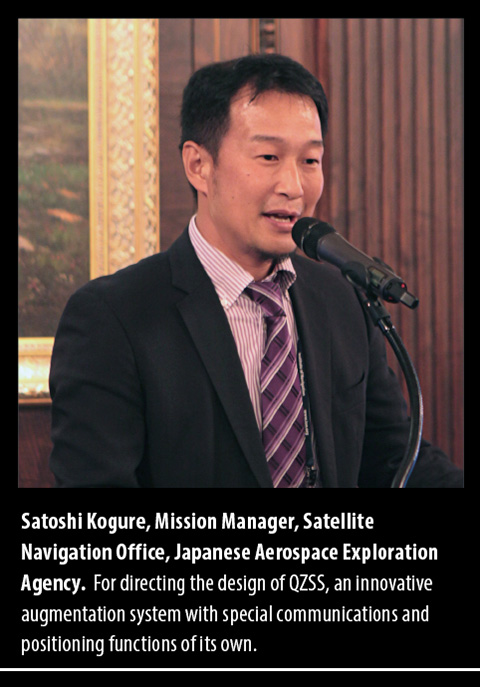
Success with a New System, QZSS
Japanese Government Approves a Four-Satellite Constellation
It is my great honor to receive this GPS World Leadership Award 2013 on behalf of my team. I’d like to express my gratitude to my family, my colleagues, and especially my team members. We jointly developed the first satellite of the Quasi-Zenith Satellite System in Japan.
The project was established after long discussion between the Japanese government, industries, and user communities, as well as other GNSS providers. QZSS is now providing GPS availability and capability enhancement to Asia and the Oceania region as a regional augmentation system. We are very proud of a great achievement on the first satellite technical validation. Our first satellite can provide the same signal-in-space user range error performance as the latest GPS Block IIR-M and IIF space vehicles.
As a result, considering our achievement, the Japanese government has decided to proceed with the QZSS program to the second phase. So we will have three additional satellites by 2017 and we’ll start the augmentation service surrounding Japan, East Asia, and the Pacific region from 2018, using the four-satellite constellation.
The Japanese government is conducting the system design for the operational QZSS, and the Japanese Aerospace Exploration Agency is continually supporting the government’s activity. We expect that QZSS will bring great social benefits to life in the Asia-Pacific region in a wide variety of fields.
Again, on behalf of all the people who have been involved in the QZSS project, I give my sincere appreciation for this reward. I would also like to acknowledge everybody in this room, because we have learned so many things from this wonderful society. So it is my great pleasure to share my gratitude with you. Thank you very much.
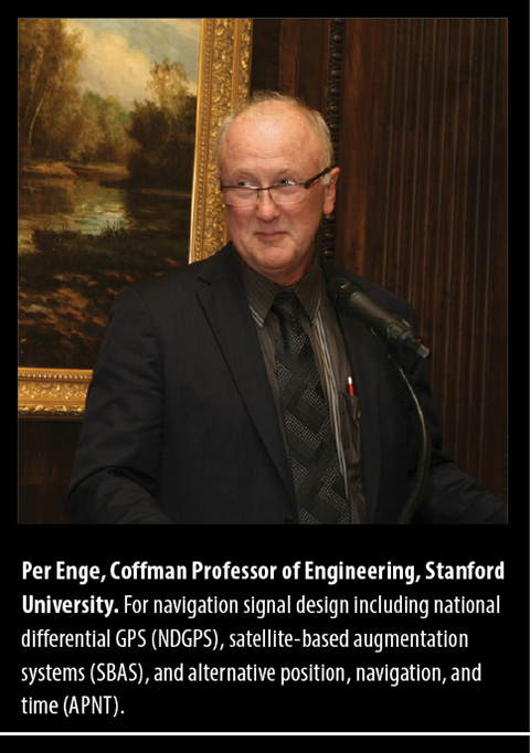
The One Constant: New Challenges
Jamming, Spoofing, Squeezing, Security, and More
First and foremost, thank you for this wonderful award. It caused me to reflect on all of the wonderful people that I have worked with over the years. This morning, I tried to list these people for NDGPS, WAAS, and APNT; and the lists were too long to repeat in five minutes. For WAAS alone, the list includes people from the Federal Aviation Administration, Stanford University, AJ Systems, RTCA, Raytheon, Zeta, Inc., and the Mitre Corporation. This beautiful award reflects on the efforts of everyone on these long lists.
These lists also remind me of the remarkable community that is GNSS today — all of us. Apparently, we still have our work cut out for us. After all, I understand from this very conference that:
GNSS is blocked;
GNSS is jammed;
GNSS spectrum will be squeezed;
GNSS is spoofed;
GNSS is scintillated;
GNSS is too expensive;
GNSS is Swiss cheese (thank you, Nunzio).
Honestly, I was not really aware that GNSS is all that fragile. It seems to work fine to me. But let us take the point: these threats are worth our worry, and mitigation will require the full strength of our far-flung community.
Spoofing is worth some special mention. It is certainly interesting, and the theory will be gorgeous. However, I remind you of Faflick’s theorem:
“In your professional life, you will work on many interesting projects. With luck, you will work on some important projects; those will be important to your company, your nation to the global community. However, (Faflick asserts) you will never ever work on any projects that are both interesting and important.”
Well, it seems that GNSS and WAAS are exceptions. But two such small exceptions should not cause us to turn our back on a theorem as powerful or persuasive as the one provided by Faflick. If we apply the theorem, then spoofing cannot be important, because it is interesting. However, I think spoofing is also an exception to Faflick’s theorem.
After all, today’s e-security is based on three security factors: what we know (passwords), what we carry (key fob), and what we are (fingerprints, iris scan). And it is not enough. For example, our health records will soon be online, and the damage caused by losing control of these health records would be great. To meet this challenge, we need to rejuvenate the original security factor: location. In the past, transactions were secured by our presence. In the world of e-commerce, this factor has disappeared, and we must use GNSS to approximate this ancient and effective security factor.
All of this will require the best effort of this precious community of ours.
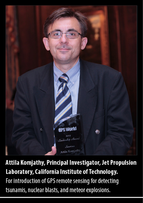
Science Powers New Applications
Radio Occultation Techniques May Warn of Natural Disasters
I am deeply honored to receive GPS World’s GNSS Leadership Award this year. Many thanks to the magazine and the international group of GNSS experts for recognizing my contributions to the GNSS community with this prestigious distinction.
I have been privileged to receive support and guidance from a great number of colleagues and friends over the years — too many to list, but I thank them all. If I am a good researcher, it is because I had excellent mentors. Chief among them is Professor Richard Langley of the University of New Brunswick, sitting in the audience, who believed in me and taught me to leave no stones unturned in my research and to continue questioning myself along the way.
Professors George Born and Penina Axelrad also had immeasurable influence on me at the University of Colorado in becoming a GNSS researcher. I am greatly indebted to Tony Mannucci and Brian Wilson at NASA’s Jet Propulsion Laboratory for creating a stimulating, conducive, and rewarding research environment in my group at JPL. I would like to thank my wife Katie and sons David and Adam who have been most patient and who have supported me all these years.
At the early stages of my career, working with GPS data at the University of New Brunswick, we routinely had access to about 40–50 GPS receivers worldwide, and this was after a laborious process of hunting down individual RINEX files. Now, we process data from about 1,200 GPS and GLONASS stations daily in an automated fashion including daily, hourly, and streaming GPS sites. Data centers including ours at JPL generate real-time products to retrieve three-dimensional electron densities using global assimilative ionospheric modeling and other techniques. As computational power increases, I envision that we will see new scientific discoveries evolving with real-life applications and tangible benefits to society. These emerging applications already include the detection of small perturbations in the ionosphere using GNSS real-time measurements that may be indicative of natural hazards generating acoustic and gravity waves in the atmosphere.
Why is this important to us, other than being of scientific interest?
The advances in GNSS ionospheric measurements may soon be capable of augmenting tsunami early-warning systems, for instance. Other potential applications include detecting volcanic eruptions in remote corners of our planet using GNSS data. Less innocent yet equally important may be detecting nuclear tests using GNSS ionospheric measurements.
Another scientific application in the works is the creation of three-dimensional coupled ocean-atmosphere-ionosphere modeling capabilities. These models are at the initial phases of development, running on supercomputers including one at JPL. In a few years, we expect to see that coupled physics-based modeling will help detect and confirm natural hazards and artificial explosions on the Earth’s surface.
In a not too distant future, I anticipate that we will see natural hazard-generated signatures detected using low-Earth orbiting satellites. Initial results suggest that some of the largest events including large earthquakes, tsunamis, and meteor events may be detected in radio occultation measurements. I expect to see a fleet of low-Earth orbiters monitoring Earth’s ionosphere in real time, looking for signatures of tsunamis, earthquakes, volcanic eruptions, meteor events, large forest fires, or nuclear tests.
It is also tempting to use this technology and associated algorithms to claim ionospheric precursors of earthquakes. While I am not convinced about the technical feasibility of ionospheric earthquake precursors, it is a fascinating research area, which has generated heated debates in the community over the years.
With the abundance of different constellations including GPS, GLONASS, BeiDou, QZSS, and others using ground and space-based observations, we are clearly entering a new era when mid-ocean 10-centimeter-level tsunami waves may be detected in the ionosphere at 400 kilometers altitude in real time! Could you have imaged even only 10 years ago that by looking at real-time ionospheric measurements we could infer 10-centimeter-level tsunami waves well before they reach a shoreline? This might help decision makers to save human lives and potentially billions in material damages.
In closing, let me repeat that I am deeply honored to have received the GPS World Leadership Award. I look forward to continue pushing the boundaries of scientific and technical discoveries using GNSS technologies.
Thank you very much.
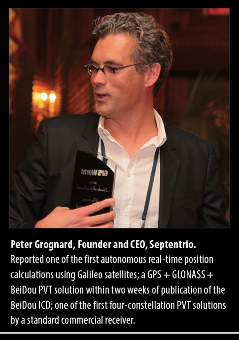
Getting to the Plus in GNSS
Multi-Constellation, Environments, Multi-Sensors
Dear friends, dear colleagues, it is with pride that I receive this award tonight, in this very town where I attended ION GPS for the first time in 1998, and where I met some of you for the very first time.
Septentrio didn’t formally exist then, but while at the Interuniversity Microelectronics Center IMEC in Belgium, and just returning from a four-year assignment in the United States, where I witnessed the beginning of civil GPS, I was preparing the creation of the company that I am so proud of, and that is first and foremost a very international family of unique, talented people that I enjoy working with every day!
Hence, my first words of gratitude go to my world-class team that for 15 years now has been at the forefront of advanced GNSS receiver development.
I also take the opportunity to thank some of our long-standing customers and partners, who all those years have given us their business and confidence. In particular, let me thank here tonight the European Space Agency, with whom we have worked hand in hand for more than 10 years. Thank you for your confidence and business — it is a tremendous honor to work with you, and we have enjoyed the truly historic milestones on the Galileo program as much as you have.
As the motivation for tonight’s award, a number of important new developments were mentioned, as achieved by Septentrio throughout an already very busy year:
the successful position/velocity/time (PVT) calculation using BeiDou satellites in a three-constellation solution on a commercial PolaRx4 platform just days following the official release of BeiDou’s Interface Control Document;
the first autonomous real-time Galileo PVT calculation. The standalone position was calculated from in-orbit navigation messages using a standard PolaRx4 GNSS receiver equipped with commercially released firmware;
the first four-constellation PVT performed by a standard commercial receiver. The 3D-position fix happened shortly after the Galileo IOV satellites began transmitting, for the first time ever, a fully usable navigation message as part of an ESA experiment;
and last, but certainly not least, the first Galileo PRS-only positioning for European Secured Navigation using only the encrypted Galileo Public Regulated Service (PRS) signals broadcast by the four Galileo In-Orbit Validation satellites.
I’ll share with you some future directions for us, outlining three major themes running across our developments.
When we first met here 15 years ago, the focus of our industry was all about GPS. Today, our favorite yearly rendezvous has been rightly renamed ION GNSS PLUS. GPS is not alone anymore. Not alone, because who today would give up the great signal availability that multi-constellation reception brings us? Not alone, because who would claim that GPS can survive in its own bubble of safety without considering the environmental conditions it lives in?
Finally, not alone because modern positioning and navigation require multi-sensor fusion to perform at their best.
Multi-Constellation Reception. Septentrio has, from its very beginning, focused on developing multi-frequency, multi-constellation receivers, at a time when this was far from common. Our first proprietary ASIC was a highly integrated GPS-GLONASS-SBAS chip, which we used as the core of the first generation of Septentrio multi-system/multi-frequency receivers.
“All the signals in the sky” was, is, and will always remain one of our key leitmotifs. We follow with great interest the new developments around the world, for instance for future-generation EGNOS and Galileo systems. As a practical example, I’d like to mention the work that we conduct with European partners on EGNOSv3.
Also, it’s my pleasure to announce here tonight the development of our fourth-generation correlator ASIC, GReCo4: all–in-view, all-signals, all-Septentrio!
The consistent focus on multi-system, multi-frequency receivers was obviously driven by the desire to make very powerful, robust GNSS receivers that would provide high-precision PVTs under the widest range of circumstances.
Our unwavering support for Galileo from the early days was also based on the fact that we could, at the turn of the century, easily receive 15–20 satellites: GPS+GLONASS+EGNOS.
Environments. Obviously, no matter how many independent systems are combined, GNSS remains vulnerable and sensitive to all kinds of interfering sources, human-made and made by Mother Nature. That’s why in recent years, we have been investing a lot of effort in understanding and mitigating the environmental disturbance that affects GNSS receivers.
While we must be humble for, and cannot (completely) tame the forces of Mother Nature, Septentrio has spent a lot of effort on ionospherical receivers. These developments have been conducted by a Septentrio-led consortium of European and Brazilian partners, with as a tangible outcome the Septentrio PolaRxS receiver, aimed at measuring the ionosphere. This unique state-of-the-art receiver is being deployed worldwide by our customers and partners, which helps us improve our understanding of ionopheric behaviour and its impact on GNSS receivers. Our goal: making the most robust professional receivers in the world.
With respect to interference, both intentional and unintentional, Septentrio will continue to improve and expand its solutions. Septentrio’s state-of-the-art Advanced Interference Mitigation (AIM) is AIMed at providing our customers the most robust reception under adverse and hostile conditions.
Multi-Sensors. “All of the signals in the sky” only works if your receiver sees the sky. If there are no satellite signals — for instance, because of blockage of the signals in a container terminal — one obviously needs other sensors to take over and guarantee the continued availability of a PVT-solution.
For several years, we have been offering combined GNSS-INS solutions for a variety of applications, such as management of container terminals. One of our very first customers was the Port of Singapore Authority.
Septentrio will continue to work along these three exciting axes. We look forward to communicating new trends and developments to you wonderful, global GNSS+ community!
Explosive growth in the UAV market is the focus of a free GPS World webinar this Thursday. Most on-board navigation systems in UAVs — unmanned aerial vehicles (UAVs) — rely on GNSS or GNSS with inertial aiding.
As military budgets decline, interest in civilian commercial applications is growing rapidly. The FAA recently awarded special type certification to two UAVs for commercial Arctic operations, and the industry is now poised for the opening of the regulation floodgates to address a growing commercial demand.
In Thursday’s webcast, “Unmanned Aircraft Navigation,” participants will hear from industry leaders in GNSS-based navigation for UAVs, in both the military and civilian sectors: they will tell us what they are doing in UAV navigation and where they see this exciting market going.
The webinar will be held Thursday, November 21, 10 a.m. PST / 1 p.m. EST / 6 p.m. GMT. Registration is free.
Guest Speakers
Olivier Casabianca, Business Area Manager, Trimble GNSS OEM
Casabianca works on the Trimble GNSS OEM portfolio which includes both the Trimble and Ashtech receiver module product lines. He joined Trimble in 2011 with the Ashtech acquisition where he was driving the Ashtech GNSS Technology roadmap and OEM portfolio. He has worked in the GNSS industry since 1997 and has held various positions in Engineering (RTK, GNSS Heading and Attitude firmware engineer, program management, engineering manager) and Marketing. He is located in Nantes area of France.
Hal Adams, Chief Operating Officer, Accord Technology
Hal Adams is founder and Managing Director of AvValues LLC which partnered with Accord Software & Systems, Bangalore, India to form Accord Technology LLC of Phoenix, Arizona USA. Adams has more than 35 years of civil and military aerospace and avionics experience in the aerospace industry, including senior leadership positions in general management, product and business strategies, development activities with Northwest Airlines, Lockheed-Martin, Litton Aero Products (now Northrop Grumman), Rockwell Collins Avionics, Thales Avionics and Aviation Communications and Surveillance Systems (ACSS – an L-3 Communications and Thales Joint Venture). As a co-founder of Phoenix Aerospace Consulting Group, Adams’ oversight responsibility was leading the NexNav business area which provided the industry’s first certified GPS WAAS Beta-3 sensors to the commercial aviation marketplace.
Neil Gerein, Defense Product Manager, NovAtel
Neil Gerein joined NovAtel Inc. as a GPS Software Engineer in 2001. Since 2009 he has worked as the Defense Product Manager for NovAtel. He is responsible for the navigation warfare product lines, including the GAJT GPS Anti-Jam antenna and OEM625S SAASM receiver used in unmanned vehicle systems. He holds B.Sc. and M.Sc. degrees in Electrical Engineering from the University of Saskatchewan, where he specialized in digital signal processing. Neil currently serves on the Council of the Institute of Navigation, as well as on the executive of the Alberta regional section of the Institute of Navigation.
Eric Brewer, Senior Systems Engineer, Rockwell Collins
Eric develops and tests guidance, navigation, and control algorithms for unmanned and optionally piloted aircraft. He was a key contributor to Rockwell Collins’ damage tolerance program, which successfully recovered a sub-scale F18 after simulated battle damage ejecting more than 75% of the right wing. As lead systems engineer, Eric spearheaded the successful integration of SAASM RTK on the STUAS program. He received a B.S. in Mechanical Engineering from Penn State in 2008, and an M.S. in Mechanical Engineering specializing in autonomous rotorcraft from Virginia Tech in 2009. When he’s not programming away in MATLAB, Eric enjoys hiking, rock climbing, and testing the damage tolerance capabilities of R/C airplanes and helicopters.
Howard William Loewen, President, MicroPilot Inc.
Howard is the president of MicroPilot Inc. Howard has a degree in Electrical Engineering with an option in Computer Science and a Masters degree in Computer Science both from the University of Waterloo. Howard has been involved in the UAV industry since 1994 when he started MicroPilot. Under Howard’s leadership, MicroPilot was the first to introduce a single board, fully integrated UAV autopilot into the market, the first to introduce ultra lightweight autopilots, the first to introduce a triple redundant UAV autopilot among others. MicroPilot has continued this tradition of leadership with its recent introduction of XTENDERvalidate a requirements management tool designed specifically for UAV system integrators.
As smartphones embrace always-on, ubiquitous location, location-based sensor fusion will become a standard feature. ABI Research’s report, “Location-based Sensor Fusion: Companies, Technologies, and Revenue Opportunities,” outlines how sensor fusion will evolve to support indoor location and the companies best placed to succeed in this space. Location-based sensor fusion will enable the dawn of the quantified self, ambient intelligence, as well as provide huge potential around advertising and retail, ABI Research said.
Senior analyst Patrick Connolly comments, “Sensor fusion is vital in enabling a consistent location experience, RF mapping, and the industry to scale rapidly. Unfortunately, it is not just a case of putting in a 9-axis sensor to achieve this. Highly complex algorithms are required to optimize sensor outputs, integrate with other location technologies and combine with machine learning and data-fusion algorithms. Sensor fusion will surpass Wi-Fi and BLE as the most important handset-based indoor location technology by 2017.”
ABI Research has forecast the adoption of different indoor location technologies, and the companies best placed to be successful. “We see a significant trend towards hybridization, with Wi-Fi, BLE, and senor fusion proving to be vital. By 2014, hybrid solutions will have already surpassed standalone indoor location technologies on smartphones. Longer term, technologies around optical light, object recognition, and LTE-direct are all forecast to offer differentiation,” continues Patrick Connolly.
VP and practice director Dominique Bonte adds, “The market is largely divided between Sensor IC OEMs, GPS/connectivity IC OEMs, and a group of really interesting start-ups. Companies like Movea, HillCrest, indoo.rs, and Senionlab are creating some intriguing solutions and will represent the next generation of acquisitions and partnerships in indoor location.”
These findings are part of ABI Research’s Location Devices Research Service, which includes Research Analyses, Market Data, Insights, Presentations, and Competitive Assessments focused on the indoor location market.
According to a new report by Research and Markets, the winners in making and operating mobile phones will offer the most compelling new functionality, IPS being a major enabler. The winners in making, integrating and operating RTLS will reduce cost and improve usefulness, not least to encompass mobile phones and other mobile computing. The world’s largest companies are locking horns on this.
The term Indoor Positioning Systems (IPS) primarily concerns location-based services on mobile phones where GPS does not work. The term Real Time Locating Systems (RTLS) primarily concerns locating people and things at a distance, securely, using second generation RFID. The subjects are converging with Apple, Samsung, Google, Nokia, Microsoft, Hewlett Packard and IBM clashing for the tens of billions of dollars of business that is emerging.
This subject heavily involves short range communications, notably Wi-Fi and Bluetooth, and inertial navigation and advanced RFID as it progresses to determining 3D position including orientation and line of travel. Emergency services, healthcare, retailing, manufacturing, logistics and many other industries will be transformed by what is becoming possible, Research and Markets said.
The topics of IPS and RTLS embrace a value chain from research and consultancy to software, services, hardware, integration and facilities management. Mobile phone app developers and value added enhancements plus ecosystems of mobile phones, web services and more are also involved.
Most of the development and use is in the USA, but other territories are racing to catch up. For example, the new Indoor Location Alliance came from Europe but has global players and companies, such as Samsung in East Asia, and is taking an exceptionally broad view from new phone design to RTLS in smart cities. Siemens in Europe and several Japanese and U.S. companies seamlessly integrate GPS outdoor navigation and services with IPS and RTLS.
This report consists entirely of evidence-based analysis following seven years of conferences, masterclasses and reports on the subject produced by the PhD level IDTechEx analysts and team.
The main features of the report, which is continuously updated, are the following:
Ten year forecast of the RTLS market 2014-2024, platform hardware vs system integration/services.
Full explanation of what IPS and RTLS are and how these technologies are evolving and converging, with detailed, original graphs and diagrams, largest orders landed and lessons arising. Threats, opportunities and company strategies are revealed.
Comparison of 105 organisations in the IPS/ RTLS value chain by country, basic measuring principle, standards, frequencies, protocol, range, accuracy, applications targeted and background information. Pie charts and graphs give analysis by parameter.
Comparison of 74 case studies of RTLS with many pie charts presenting the lessons arising.
Detailed original interviews carried out from mid 2013 with important organisations in this space.
Glossary of the challenging jargon, which is different between IPS and RTLS yet often refers to the same or similar things.
Sales of smart glasses, smart watches and wearable fitness trackers reached 8.3 million units worldwide in 2012, up from 3.1 million devices in the previous year, according to researchers at Berg Insight. Growing at a compound annual growth rate of 50.6 percent, total shipments of wearable technology devices are expected to reach 64.0 million units in 2017.
According to the announcement, today wearable fitness and activity trackers constitute the vast majority of the shipments. By the end of the forecast period, smart watches are predicted to incorporate much of the functionality of these and will then be the largest wearable device segment. “A perfect storm of innovation within low power wireless connectivity, sensor technology, big data, cloud services, voice user interfaces and mobile computing power is coming together and paves the way for connected wearable technology,” said Johan Svanberg, senior analyst, Berg Insight.
The first generation of products appeal to specific markets and certain use cases, but refinement in design, technology and connectivity will broaden application areas and speed up market adoption. Initially, the wrist is the most attractive location for wearable devices, which is shown by the success of the Pebble smart watch and the popularity of wristband activity trackers such as the Nike Fuelband and the Fitbit Flex.
“However, today’s devices need to evolve into something more than single purpose fitness trackers or external smartphone notification centers in order to be truly successful,” continues Svanberg.
Berg Insight predicts that wearable technology will shift from being smartphone accessories into becoming proper stand-alone computing devices. Furthermore, closeness to the body and always aware capabilities will enable them to be more than merely miniaturized smartphones. Google, Sony and Samsung have already launched products and other major players such as Apple and LG are expected to soon enter the market. Wide market availability of wearable devices also raises privacy concerns. “It is still uncertain where lines should be drawn, but as in the case with most new technology, individual users and solution providers have the responsibility not to misuse the capabilities enabled by wearable tech,” concludes Svanberg.