Tag: GNSS industry

  • Qualcomm to Acquire SiRF Chipmaker CSR

    Qualcomm_CSR_acquisition_logos-TQualcomm, Inc., has agreed to buy British CSR for $2.5 billion, to enhance its automotive infotainment and Internet of Things (IoT) offerings. CSR is known to the GPS/GNSS industry as the maker of the SiRFstar series of chips, which are used in many consumer devices. Qualcomm is a leading maker of chips used in smartphones.

    According to Qualcomm, the acquisition complements the company’s offerings by adding products, channels, and customers in the important growth categories of Internet of Everything (IoE) and automotive infotainment. “This opportunity is aligned with Qualcomm’s established strategic priorities in these rapidly growing business areas,” according to a Qualcomm statement. The transaction is expected to close by the end of the summer of 2015.

    Once the transaction is complete, the two major U.S. wireless/mobile-chip design/manufacturers will have GPS/GNSS technology firmly embedded within their organizations. In July 2007, Broadcom acquired Global Locate. More recently, CSR acquired SiRF Technology in June 2009, and now CSR has in turn been acquired by Qualcomm. Throughout 2008, Broadcom and SiRF were locked in a patent battle that Broadcom eventually won, precipitating a decline in SiRF’s one-time dominance and sending it into eventual disappearance/acquisition by CSR. The two companies are again aligned as opponents as part of the rival camps, Qualcomm and Broadcom, whose competition is fully as intense as the former Global Locate (then Broadcom) versus SiRF tussle.

    “The addition of CSR’s technology leadership in Bluetooth, Bluetooth Smart, and audio processing will strengthen Qualcomm’s position in providing critical solutions that drive the rapid growth of the Internet of Everything, including business areas such as portable audio, automotive and wearable devices,” said Steve Mollenkopf, chief executive officer of Qualcomm Incorporated. “Combining CSR’s highly advanced offering of connectivity technologies with a strong track record of success in these areas will unlock new opportunities for growth. We look forward to working with the innovative CSR team globally and further strengthening our technology presence in Cambridge and the UK.”

    The full announcement, issued in accordance with Rule 2.7 of the UK Takeover Code, can be found on Qualcomm’s website at www.qualcomm.com/2.7.pdf.

  • 2014 State of the GNSS Industry Report

    The 2014 State of the GNSS Industry Report reveals the results of our annual survey of GNSS professionals, covering the state of their business, the economic climate for GNSS products and services, driving market factors, the government’s role in funding and regulating, budgets devoted to R&D, the effects of jamming, and the “Issue of the Year.” Click here to download the 2014 State of the Industry Survey, sponsored by NovAtel, Trimble, and u-blox.

    GPSWorld_SOIR_2014-cover Photo: GPS World
    Download the PDF. Photo: GPS World


  • GPS World Leadership Dinner and Race to Market

    Invited guests at the annual GPS World Leadership Dinner, a special event held September 11 during ION GNSS+ in Tampa, Florida, heard perspectives from sponsors Lockheed Martin, Exelis, Raytheon, and Braxton Technologies, as well as visions of GNSS progress from our four award winners.

    Leadership Awards were given to Javier Benedicto Ruiz, Galileo Project Manager, European Space Agency (Satellites category); Sherman Lo, senior research engineer and associate investigator (APNT), Stanford University (Signals category); Eric Gakstatter, contributing editor for survey and GIS, GPS World (Services category); and Oliver Montenbruck, head of GNSS Technology and Navigation Group, DLR, German Space Operations Center (Products category).

    Over dessert, each table rose to the challenge of creating a phenomenal GNSS product or service and then competed in car races at the track.

    More coverage of the awards will appear in the December issue.

  • Satlab Geosolutions Adds Americas Office, Appoints Phil Gabriel

    Satlab Geosolutions Adds Americas Office, Appoints Phil Gabriel

    Satlab products include (from left) the SL600 6G GNSS receiver, the SL300 6G GNSS receiver, and the SL55 controller. Photo: Satlab Geosolutions AB
    Satlab products include (from left) the SL600 6G GNSS receiver, the SL300 6G GNSS receiver, and the SL55 controller. Photo: Satlab Geosolutions AB

    Swedish-based survey and GIS equipment maker Satlab Geosolutions AB has expanded into the U.S. and Americas with the creation of a new sister company Satlab Geosolutions (USA), Inc., based in Scottsdale, Arizona. Phil Gabriel has been named managing director of the USA office.

    Setting up a formal base of operations in the U.S. will allow Satlab to better service their clients and expand their customer base in the U.S., Canada, Mexico and Latin America, a company release said. As past president of Hemisphere GNSS, Gabriel brings to the team his many years of experience in the survey, GIS, GNSS, machine control, marine and navigation industries, Satlab said.

    The U.S. location will sell, support and service the new product lineup being introduced at InterGeo in Berlin, Germany, on October 7.  Satlab is seeking dealers to expand its business throughout the Americas.

    “The addition of a U.S. office is an exciting next step for us, after successful expansion into Turkey and the Czech Republic in the last few years,” said Bjorn Agardh, CEO of Satlab Geosolutions AB.

    “Our products have been well received and continue to perform extremely well,” added Birol Gucluer, CTO and partner of Satlab.

    “I’m excited to join Bjorn and Birol, extending their success by ensuring their high standards in customer service are maintained here in the Americas,” Gabriel said.

    Satlab invites Survey and GIS dealers to meet the expanded team at InterGeo October 7-9 in Berlin, where they will be introducing several new models of their popular receivers and handhelds.

  • Septentrio Consolidates Sales for Americas in Altus Subsidiary

    Altus Positioning Systems, a subsidiary of Septentrio Satellite Navigation NV, has assumed responsibility for Septentrio products in North and South America.

    Septentrio — a manufacturer of high-end GNSS receivers for demanding professional navigation, positioning and timing applications — is consolidating its sales, service and customer support functions for the Americas in Altus’ facility located in Torrance, California.

    “This decision to base Septentrio’s sales and support functions for the Americas with Altus marks the next logical step in our evolving business relationship and professional collaboration with our parent company Septentrio,” said Neil Vancans, president of Altus. “We look forward to leveraging the strengths of both our organizations to grow the market for Altus and Septentrio products across a wide range of market sectors.”

    Altus has added industry veteran Mo Kapila as OEM sales manager for Septentrio products. Kapila is based in Altus’ office in Torrance, California. Before joining Altus, he was vice president of sales for Qualinetics, a pioneer in vehicle telematics.

    Kapila previously held senior sales management and business development roles at B&B Electronics and Quatech, as well as OEM product management positions at DENSO and Clarion Corporation. He is a graduate from the University of Michigan with a B.S. degree in mechanical engineering.

  • 25th Anniversary GNSS Timeline

    GPS_World_25_Year_Timeline_Page1

    GPS World’s 25th Anniversary GNSS History Timeline, from the September 2014 Special Supplement “GNSS Industry: Past, Present, and Future.” Download the PDF.

  • New GNSS Market Outlook Report Forecasts to 2020

    Research and Markets has announced the addition of the “GNSS Market Outlook 2020” report to its offerings.

    Research and Markets explained that GNSS has developed its applications across various industries worldwide. Some applications are simple, such as determining a position, whereas others are complex blends of GNSS with communications and other technologies. Over the past few years, the rapid growth in GNSS commercial applications has been observed by the firms building navigation satellites and equipment. According to the report, the GNSS market is expected to flourish with new technological applications and is anticipated to grow at a CAGR of 9.4 percent during 2014-2020.

    The report “GNSS Market Outlook 2020” is an outcome of the research company’s exhaustive research and comprehensive analysis of the worldwide GNSS market. “Our report provides a complete overview of the GNSS market globally. Over and above, all the current trends and drivers coupled with the potential growth areas of the GNSS industry have been evaluated in the report,” the company said in a statement.

    The report analyzes the GNSS market by its major application areas such as location-based services, transportation, surveying, and agriculture, over a period of eight years (2013-2020). In addition, the transportation section covers the GNSS market by road, rail, air, and marine navigation segments, which are creating a wide opportunity to the overall GNSS market, according to the report.

    The report provides extensive analysis of the GNSS market by each of these segments up to 2020.

    Topics Covered:

    1. Analyst View

    2. Research Methodology

    3. Global Navigation Satellite Systems (GNSS) – Overview

    4. Current Industry Trends

    5. Market Outlook to 2020

    6. Key Country Profile

    7. Potential Growth Areas

    8. Competitive Landscape

    Companies Mentioned:

    • AgJunction
    • CSR
    • Furuno Electric Co Ltd.
    • Garmin Ltd.
    • MiTAC International Corp.
    • Raytheon Company
    • Rockwell Collins
    • TomTom NV
    • Topcon Corporation
    • Trimble Navigation Ltd.
  • Take Our State of the Industry Survey, Win Prizes

    Take Our State of the Industry Survey, Win Prizes

    soi_cvr2013

    What are your challenges this year? How are you driving business in today’s economy? What issues are you concerned about? We want to know, and so does the rest of the industry.

    GPS World is conducting its annual State of the Industry Survey asking GNSS professionals about the state of their business, the economic climate for GNSS products and services, driving market factors, the government’s role in funding and regulating, budgets devoted to R&D, the effects of jamming, and the “Issue of the Year.”

    This GoPro Hero3 video camera could be yours.
    This GoPro Hero3 video camera could be yours.

    Everyone who takes the survey will be automatically entered in a drawing for these prizes:

    • A GoPro Hero3 professional-quality video camera
    • A pair of tickets to GPS World’s 2014 Leadership Dinner (for those not attending ION GNSS+ in Tampa, Florida, we’ll send a voucher for a comparable dinner in your hometown);
    • $50 Mastercard gift cards

    The survey should take about 10 minutes, and your responses are confidential.

    Complete the survey by August 31. Then look for a complete report of our findings in the October issue of GPS World.

    Click here to begin the survey.

  • InvenSense to Acquire Sensor Nav Companies Trusted Positioning and Movea

    InvenSense, Inc., a provider of intelligent sensor solutions, has signed a definitive agreement to acquire Trusted Positioning, Inc. (TPI), a privately held indoor/outdoor tracking company with the vision to provide “Positioning Everywhere.” InvenSense is also acquiring context analysis software company Movea.

    TPI’s location tracking technology improves accuracy both indoors and outside by augmenting GNSS and Wi-Fi based location infrastructure. Using inertial sensors such as accelerometers, gyroscopes, magnetometers, and pressure sensors in mobile and wearable devices, TPI’s software platform provides continuous and accurate positioning and also solves the difficult problem of alignment between the user and the mobile device. The TPI platform provides complete inertial navigation software solutions for a variety of industries including smartphones, tablets, wearables, in-vehicle navigation, personnel tracking, and machine guidance and control.

    “InvenSense shares our passion for ‘positioning everywhere,’ and they have been a strong supporter of the Trusted Positioning team, technology and vision,” said Chris Goodall, Trusted Positioning’s chief executive officer. “We are pleased to be joining the InvenSense family with the goal of making indoor/outdoor positioning ubiquitous. Together with InvenSense we will now have the required resources and investment to mainstream this technology.”

    InvenSense has also signed a definitive agreement to acquire Movea, a privately held company that provides software for ultra-low power location, activity tracking, and context sensing. Movea’s products, technology, and IP cover a broad range of signal-processing and data-fusion technology applied to consumer mobile (smartphones and tablets), TV interaction, and wearable sports and fitness applications.

    Movea is dedicated to context analysis using both motion and audio sensors to determine, for example, a person’s state/activity, their energy expenditure, their location, and an athlete’s speed and cadence. Movea’s algorithm and software framework expertise is expected to further scale InvenSense’s leadership in motion software and accelerate InvenSense’s “AlwaysOn” low-power solutions for mobile and the Internet of Things.

    “With the addition of Movea and TPI, InvenSense achieves a significant milestone as it transitions to a leading provider of intelligent sensor System on Chips (SoC) for the fast growing mobile market. ‘AlwaysOn’ location and activity tracking are essential to enabling contextually aware products and services,” said Behrooz Abdi, president and chief executive officer, InvenSense. “The tight integration of our low-power, high performance, motion and sound sensors, along with TPI’s advanced location tracking software and Movea’s data fusion algorithms, will position us to deliver on this ‘AlwaysOn’ promise.”

    In connection with the acquisition of both companies, InvenSense expects to pay approximately $81 million, net of cash assumed, to acquire all of the outstanding shares of capital stock and other equity rights of Movea and Trusted Positioning, Inc. The purchase price will be paid with $6M of InvenSense common stock and the remainder in cash, except that portion attributable to unvested employee stock options will be paid in stock options exercisable for shares of InvenSense’s common stock.

    A portion of the cash consideration payable to the stockholders will be placed into escrow pursuant to the terms of the acquisition agreement. The estimated financial impact of the acquisitions upon the future operating results of InvenSense, which is not expected to be significant, will be discussed during the next regularly scheduled quarterly investors analyst conference call planned for July 29.

    The boards of directors of InvenSense and the two companies have approved the mergers. The transactions are expected to close by the end of InvenSense’s second quarter, September 30, and remains subject to the satisfaction of regulatory requirements and other customary closing conditions.

  • Qualcomm Tops ABI’s GNSS IC Vendor Assessment, MediaTek Enters Top 3

    Qualcomm Tops ABI’s GNSS IC Vendor Assessment, MediaTek Enters Top 3

    GNSS-IC-WABI Research’s 2014 GNSS IC vendor matrix names Qualcomm as the leading GPS integrated circuit (IC) vendor, followed by Broadcom in second place. For the first time, MediaTek achieves a top three finish after another year of strong growth and robust shipments as a result of its targeted design strategy, ABI Research revealed in its “GNSS IC OEMs” report.

    The vendor matrix compares companies on 17 criteria across the broader categories of GNSS Innovation and Implementation. Qualcomm remains the dominant player with a strong ubiquitous location platform in IZat — this will be vital for success in high volume cellular handsets in 2015. It is also in a strong position to grow in other GNSS markets.

    Broadcom continues to compete aggressively through innovation, receiving the highest score for this category for yet another year. Already in 2014, Broadcom has announced its concurrent tri-band BCM 47531 IC and the BCM 4771 GNSS SoC designed for wearables, featuring a sensor hub and always-on capabilities. Finally, it has also announced its 5G Wi-Fi SoC, which supports its new proprietary FTM-based AccuLocate technology.

    u-blox has also moved up a position to fourth in this year’s assessment. It continues to grow revenue year-on-year, with little to suggest this will change in the coming year. It is also the first time u-blox has finished ahead of CSR, which was ranked fifth. CSR continues to transition and faces another arduous year in 2014. It will be 2015/16 when the effects of these tough decisions are proven out to be correct or not.

    MediaTek has now emerged as a major threat, taking third on innovation and 2012 market share rankings, following very impressive shipments of its combo ICs into local Chinese smartphone manufacturers. It is also strong on PNDs/recreational and cameras, with a growing presence in other markets. Its move to fully embedded GPS in 2013 should prove significant in driving market share in the future.

    Beyond this, STMicroelectronics also deserves a mention with its new Teseo III platform giving it significant design flexibility allowing it to compete aggressively in existing markets while expanding into new opportunities.

    Other companies discussed include:

    • Cambridge Silicon Radio (CSR)
    • Galileo Satellite Navigation
    • Intel Corporation
    • SkyTraq Technology, Inc.
    • Texas Instruments Inc.
  • GPS Industry Breathes Sigh of Relief

    GPS Industry Breathes Sigh of Relief

    LightSquared-spectrum-W

    The U.S. Federal Communications Commission convened a June 20 workshop on “GPS Protection and Receiver Performance” whose bite turned out to be far less than its bark had led some in the GPS industry to fear. The hastily assembled workshop — three weeks notice was given — appeared at first notice to derive from the call for “GPS receiver performance standards” that was one of the outcomes of the LightSquared controversy of 2012. The FCC chief emphatically noted, however, before anyone else could say anything, that the meeting was “not about FCC-mandated receiver standards.” A nearly audible sigh came from the collected dignitaries.

    Perhaps the slotting of “GPS Protection” into first position within the workshop’s title might have given some clue. The meeting did turn out to be a less-than-alarming gathering of stakeholders, and in fact a reiteration of the need to emphasize and safeguard critical infrastructure and public safety — two key uses of GPS.

    Two weeks prior to the workshop, Brad Parkinson declared to the National Space-Based Positioning, Navigation, and Timing (PNT) Advisory Board that “A number of manufacturers are quite panicked over this because of the possibility of some superposition of, in essence, how you design a receiver for GPS. This could vastly affect the whole substance of what we are if carried to the point that someone dictates how you design a receiver. I think that’s kind of dangerous.”

    But the meeting, in the end, took a positive, protective, and conciliatory tone, even as the FCC continues beating the drum for more frequencies for mobile broadband, citing the need “get more out of the radio spectrum.”

    “Today is about federal and non-federal leaders coming together to discuss successful industry-driven collaborations and GPS receiver performance,” said FCC Chairman Tom Wheeler in his opening remarks. “These are not abstract issues. But let me also be specific about what today is not. It is not about FCC-mandated receiver standards. Rather it is about the best way to protect GPS operations in the context of evolving technology and adjacent spectrum activities.”

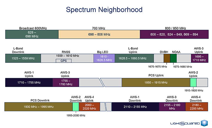
    The specter of adjacent spectrum use hovered intermittently throughout the day, appearing  fully in the presentation by LightSquared and one from the President’s representative. Otherwise, scant mention was made of the oft-expressed 2012 sentiment that GPS receivers needed to be modified in the way they work, to stop their alleged “peeking” into adjacent spectrum.

    Peekin’? We don’t need no steenkin’ peekin’!

    After further introductory remarks from the FCC’s head of Public Safety and Homeland Security Bureau, the audience heard a technology market update from the U.S. Consumer Electronics Association (CEA). The report relied almost entirely upon the European GNSS Agency’s (GSA’s) 2013 GNSS Market Report for its global statistics, while displaying some domestic charts of its own. Among the conclusions: GPS/GNSS is an enabling technology for innovation and disruption; and the consumer market, defined as road and location-based services (LBS), represents the biggest opportunity. The CEA presentation is available here.

    The morning’s first panel discussion focused on the importance of GPS for critical infrastructure and public safety users, with presentations by Qualcomm, Motorola, and AT&T in addition to various government agencies. Cormac Conroy, vice president at Qualcomm, emphasized the critical role of GPS in emergency calls from mobile phones (E-911) and what he called “enhanced location services”: vehicle and pedestrian navigation, location-based alerts and reminders, and location as context in mobile apps.

    Other speakers, including representatives from Ericsson, T-Mobile, Spirent, Garmin, NovAtel, and John Deere, covered GPS’s role in timing and thus controlling the nation’s power grid, the financial markets, the telecommunication network including cable TV, and the national breadbasket, precision agriculture. Paul Galyean of Deere said that “Certainty on the spectrum environment is needed. It’s difficult to design for the future without it.” And further, if GPS receivers had to filter out cellular activity, this “might impact sensitivity, involve excessive size or cost, and might cause distortion of GPS measurements.” The Deere presentation is available here.

    Chris Hegarty from the MITRE Corporation gave one of the day’s most compelling arguments for not overhauling GPS receiver methodology: the extremely long lead times for commercial passenger aircraft. “Until 2022 every new Boeing and Airbus is going to fly off with $250,000 worth of navigation equipment that has three $50,000 GPS receivers and antennas and everything else, and they are going to want to use that for 20 to 25 years. So, you have a timing issue. Even if we all decided today that we wanted to do that, some communities simply aren’t going to be able to get it into place until we’re all dead.”

    White House Espouses Adjacent Spectrum

    Tom Power, deputy chief technology officer for telecommunications, held up the banner for “efficient use of spectrum” and pronounced the Administration opposed to “listening in.” Ironic, given its other proclivities. He advocated against some technologies exerting undue elbow room on “nearby users who want to make a change.”

    Representing the latter contingent, LightSquared restricted its performance to showing, with reputed science, how other users such as cellular, Bluetooth, WiFi, and even laptop computers pour more power into the GPS band than does LightSquared.  The presentation of Geoffrey Stearn, vice president of spectrum development, is viewable here.


  • Arrow RF & Power Reaches Agreement with Maxtena

    Arrow Electronics, Inc., has announced that its RF & Power business will globally distribute products from Maxtena, Inc., a developer and producer for wireless solutions, including GNSS, Iridium, Inmarsat and Thuraya satellites, and terrestrial M2M, MSS and LTE applications.

    Arrow RF & Power will distribute Maxtena’s line of rugged and compact helix antennas, microstrip antennas, and combo antennas, and will also support customers with custom wireless solutions ranging from smart metering to 4G LTE. Maxtena’s products are designed for portable wireless applications including satellite phones, communications gear, handheld navigation, asset tracking, UAVs, recreational devices, and industrial equipment.

    “Maxtena’s proprietary Helicore technology provides high-performing yet miniaturized antenna solutions,” said Mark Vitellaro, director, strategic marketing, Arrow RF & Power. “Maxtena’s technical and competitive advantages combined with our technical and customer support will enable design engineers to utilize the optimum antenna solution for their needs.”

    “Maxtena is very excited to have Arrow RF & Power on board as an authorized distribution partner,” stated Vanja Maric, director of sales and marketing, Maxtena. “Their product and technology knowledge and expertise, along with their ability to form strong and lasting customer relationships make Arrow RF & Power a perfect fit for Maxtena and our unique products.”

    More information is available at www.arrow.com/rfpower.