Sessions on indoor navigation and a keynote from Google at February’s International Navigation Conference (INC15), organised by the Royal Institute of Navigation, addressed the revised E911 positioning requirements in the United States, and flowed over into speculation about E112 emergency calling parameters in Europe’s near future.
According to the 2014 U.S. Federal Communications Commission report, 75 percent of 911 calls now come from mobile phones, more than half of those originate indoors, and around 1 percent of emergency calls contain no location information from the caller (due to distress, confusion, language issues, illness, and so on). The report estimates 10,000 deaths per year in the United States might have been avoided if a landline had been used instead, since location information for landlines can be provided confidently.
Discussion in the breaks of INC highlighted a misunderstanding amongst some parties that E911 mandates the use of GPS for position location determination. In fact,E911 does not mandate any specific technology; it specifies performance criteria in terms of accuracy that must be met. The recently revised performance criteria include indoor performance, and some of the technology discussed at the INC is able to meet these requirements without using GNSS at all.
This could be troublesome for Europe, which is looking at the imposition of Galileo as part of an A-GNSS technology push for the E112 application. The real problems, discussed during INC and in European consultation processes with safety of life services such as E112, are:
the accuracy of the position derived by the device and/or network, and
the timeliness of the delivery of that position to the Public Service Answering Point (PSAP).
The E911 directives address these points directly, and the infrastructure in the cellular networks is in place. Does simply implementing a Galileo capability into a European mobile device solve these problems?
In many outdoor cases, implementing Galileo can bring benefits, including signal diversity. And of course the E112 proposal is greater than just “adding Galileo.” It does address the second problem of timeliness of delivery and data transfer, but there are significant infrastructure upgrades required across Europe for the provision of this location data to the PSAPs.
What the E112 processes do not currently do is specify performance criteria for the position location accuracy. This means that the position estimate provided under E112 is likely to be a cell-ID fix, with an accuracy ranging from hundreds of meters to dozens of kilometers.
Galileo on Mobiles. Further discussion during the conference delved into the realms of the specifics of implementing A-GNSS, including Galileo, onto a mobile device. Conversations centered around if any future E911 or E112 positioning capability would be aligned around a single-chip solution as generally currently deployed on a device, or if some of the functions will be moved up the stack into the operating system (OS) of the device, into software.
Most opinions were against this latter concept, and a panel at the ION GNSS+ last year in Florida concluded the same thing. However, questions were asked about some ideas relating to identifying the emergency number at the time of dialing and then starting the position location determination functions in readiness for the need to provide the device location. This addresses the first bullet point earlier, the accuracy of the position derived by the device and/or network. If this is carried out in the OS or software layers, vulnerability of the system will be increased overall as the OS of a mobile device is a target for the cyber criminal community.
A robust software-based solution is, however, being rolled out in the United Kingdom in the form of eSMS, bringing mobile operators, government and handset vendors together to provide location data via SMS to the PSAP. The advantage of this approach is that no new standards or major infrastructure changes are required, and the time to implement is small.
Further discussions established that future chipsets are likely to use whatever GNSS signals are available, regardless of whether they are GPS, Galileo, GLONASS, Beidou and so on. This, coupled with new signal processing techniques (single-frequency observable for example), increasing sensor clustering on devices, and user demand for services, may make the use of a specific GNSS system above others somewhat redundant. Certainly picking up on a point made by Chandu Thota from Google, GNSS is “not relevant” for their indoor positioning solutions, and technologies they are working on, in both hardware and mapping improvements, are looking at meeting indoor accuracy requirements down to a target requirement of 1 meter, without GNSS.
Taking these points into account, questions were asked from the floor of the conference about the legal position of the EC mandating Galileo as a positioning method as well as the willingness of the global mobile chipset and device industry to be told what to do. Perhaps specifying strong performance criteria, as in the United States, is the way forward to “reboot” the European E112 system. No one disputes that a properly functioning E112 is a life saver and a good thing to do; however, the points discussed here detail some of the concerns expressed during and after hours at INC15.
In February 2015, the Royal Institute of Navigation hosted the International Navigation Conference in Manchester, UK. Keynotes at this well-attended conference included Harold Martin, director of the GPS Coordination Office; Gian Gherardo Calini, the head of market development at the European GNSS Agency; Todd Humphreys from the University of Texas; Chandu Thota from Google; and others. The conference covered multiple technology tracks including indoor navigation, autonomy, quantum technology and the resilience of GNSS systems.
Andy Proctor is lead technologist for satellite navigation at InnovateUK, the UK’s innovation agency. He acknowledges Ramsey Faragher, Cambridge University, for help in the preparation of this article.
First and foremost, let’s give a big hand to Adam and Anastasia, the two Galileo FOC satellites that were successfully launched on March 27. Following the not-so-successful Galileo launch in August, it was imperative that this go smoothly.
Although the Double-A launch occurred after the conclusion of this year’s Munich Satellite Navigation Summit, anticipation of the event set the context for the entire convocation. The summit is a fixture on the European and global GNSS calendar. It is always intense, often spectacular and sometimes leaves one with contradictory feelings. This year it took place March 24-26 and sought to determine the future of PNT, encouraging delegates to look into the crystal ball and predict developments.
If we go by the number of times these words were repeated during the three days of the summit, the future will hinge around compatibility and interoperability. The multi-constellation GNSS is already here. The elephant in the room remains, as always, interference, but here integration of alternative sensors and signals should hold the key to continuous and possibly resilient operations.
As usual the summit kicked off with a high-level plenary in the imposing Allerheiligen-Hofkirche (Court Church of All Saints) in the Residenz München, the Bavarian royal palace. The welcoming speeches and presentations were interspersed with some pleasant jazz, and the atmosphere was relaxed.
Into the Crystal Ball
Matthias Petschke, director of EU Satellite Navigation Programmes at the European Commission, admitted that 2014 had been difficult, but he was looking forward to 2015. Clearly the deployment of the Galileo infrastructure — especially the space segment — was critical, and the March 27 launch was very much on his mind. However, he expressed confidence that the launch would be fine and that satellite production was, and would remain, on schedule. In the long view, he stated: “We will make it for 2020,” signifying full operational capability (FOC).
He also talked about stimulating global markets to foster uptake of Galileo and EGNOS, and this was discussed by Carlo des Dorides, executive director of the European GNSS Agency (GSA). The ground infrastructure is very much in place and preparing for the Galileo exploitation phase. A significant milestone in that process would be finding the right partner to lead Galileo operations for the next ten years. A tender was now in process to find that organization or consortium. Des Dorides described the process as a competitive dialogue with the emphasis on finding a partner who can inspire new ideas and provide innovative solutions. The contract is big, worth around 1 billion euros.
Carlo des Dorides, Executive Director of the European GNSS Agency (GSA), discusses the 1 billion euro tender, now in process to find the organization or consortium to lead Galileo operations for the next ten years. Photo: GSA
He also emphasized the successes for EGNOS in the year. Almost 180 airports now benefit from EGNOS-enabled approaches and more than 70 percent of “GNSS-enabled” farmers in EU use the EU’s SBAS.
Johann-Dietrich Wörner, chairman of the German Aerospace Centre (DLR) — and the nominated next Director-General of ESA – highlighted the growing dependence of critical services on GNSS. In this context multiple systems were not a question of competition; it was all about redundancy and safety. Multi-GNSS improves availability, accuracy and reliability.
The view from the United States was given by Harold “Stormy” Martin, Director, National Coordination Office for Space-Based Positioning, Navigation, and Timing in Washington, D.C. The GPS fleet was now 30 strong in orbit including four successful launches in 2014 and he stated the 2014 averaged user range error to be 70 cms — the best ever — and improving year on year.
One major upcoming trend is a realization that there’s a need to establish a U.S.-wide backup coverage for GPS outage due to natural or man-made interference. The U.S. is currently assessing alternatives with a decision likely in summer 2015.
There was a particularly warm welcome from the audience for Michael Khailov, deputy head of Roscosmos and co-ordinator for GLONASS. Last year the Russians were conspicuous by their absence at the Munich Summit, but for 2015, despite the intervening local difficulty in Ukraine, they were back in force. Khailov claimed that the sustainable development of the world depends on GNSS. On more esoteric ground he stated that GLONASS had maintained stable operations in 2014 and three more satellites had bene launched. Further launches would depend on operational circumstances. The user domains for GLONASS were continuously expanding. Continuing the summit text he said that it was better [working] together than separately — in fact separately often doesn’t work at all and therefore we must continue to promote interoperability and the Munich Satellite Summit is a good forum for this.
Jianyun Chen of the China Satellite Navigation bureau also took up the theme of all GNSS together. Sixteen Beidou (pronounced — for the avoidance of doubt — as ‘bay-doe’) had been launched since 2007 and the Chinese had been in discussion with Russia to ensure full interoperability with GLONASS. This process will be repeated with GPS and Galileo.
GNSS Updates
One of the idiosyncrasies of the Munich Summit is its very discreet signage. If you don’t know where it is — and specifically the correct side door that brings you up two floors to the main Max Joseph Saal venue — it is highly likely you’ll miss it! But once you are in it is two full-on days of updates on systems and discussions on a vast range of topics that impinge on the development and implementation of GNSS around the world.
Discreet signage. Photo: GSA
The first two session of the summit proper gave updates on the GNSS systems in operation and under development as well as the regional and augmentation systems. Much of the material was slightly more detailed versions of presentations at the plenary but a few news snippet emerged.
“Stormy” Martin said that a modified battery charge control had been implemented that would extend operational life for some of the fleet by one or two years. He also reiterated the improving accuracy performance of GPS which was now much better that its published standards. He predicted that the first GPS III would be available for launch in 2016 and said that GPS was improving every day.
Eric Chatre from the European Commission reiterated that Galileo was still expecting to start early services in 2016 with full operational capability in 2020. He expected 18 satellites to be launched by 2018. The new Ariane 5 launcher will enable the launch of four satellites at one time and the first launch with this system would be in 2016. In terms of the ground segment only one station in the Pacific was yet to be established.
Sergey Karutin of Roscosmos talked about a four-fold accuracy improvement for GLONASS with the use of new clocks and the introduction of new CDMA signals that will improve accuracy and access. According to Dongfeng Yu of the China Satellite Navigation Office the BeiDou constellation is moving from “regional to global, active to passive” and is aiming for global coverage by 2020.
U.S. SBAS developments were covered by Deborah Lawrence of the Federal Aviation Administration (FAA). The Wide Area Augmentation System (WAAS) now has 100 percent coverage for LPV200 in CONUS. More than 41,000 runway ends are now included, and she predicted full completion in 2016.
Jean-Marc Pieplu of the GSA talked about EGNOS status. The next system release (2.4.1) should be published in Q3 2015 and will include a significant input on ionospheric corrections. Further service evolution includes a plan to declare LPV 200 in Q4 this year and EGNOS coverage will be extended to 72 deg North and ensure full coverage of the 28 EU member states.
The Russian Augmentation system SDCM performs at 0.8 metre accuracy according to Grigory Stupak of JSC / Russian Space Systems. He noted new validated SDCM ground stations had been established in Antarctica and Brazil and stated that global exploitation was a key objective for SDCM as its satellite coverage was very wide. GLONASS and GPS together could ensure complete coverage. He also indicated that work was in hand for SDCM SBAS service certification for LPV 200 and he called for providers of all WAAS to work closely together.
2020 Vision
After lunch we were offered the chance to hear some expert views on the future of GNSS and PNT with Prof Vidal Ashkenazi of Nottingham Scientific Limited asking for their vision of GNSS in 2020. By that year there should be 100-120 GNSS satellites in orbit, multi-constellation receivers would be the norm, but what would be the new applications and what were the challenges?
Jamming and spoofing would still be issues. Pierre Bouniol of Thales thought that in civil aircraft receivers would probably incorporate jamming indicators by 2020 to inform users when signals may be compromised. For Stuart Riley of Trimble the key was integration of other sensor signals to bridge any GNSS signal outage. Gang Mao of Unicore Communications Inc. in China considered multiple frequencies to be a big help in reducing the threat of jamming. Nigel Davies of QinetiQ agreed saying there were a host of technical solutions but key for success would be solutions that use low power, are low cost and feature high usability. He also noted that safety certification of receivers for use in driverless vehicles would be required and this challenging application would need the provision of robust continuous navigation — and sub-metre accuracy.
The future market for GNSS was also discussed in a session that unveiled the GSA’s 4th Issue of its comprehensive GNSS Market Report. With almost four billion GNSS devices used worldwide and all regions experiencing growth, GNSS represents an unprecedented business opportunity. Over the past 15 months the GSA’s team of market monitoring experts has taken a close look at all aspects of the GNSS marketplace with analysis of both hardware and software market opportunities, technology trends and future developments.
Gian-Gherardo Calini, Head of Market Development at GSA, gives highlights of the comprehensive GNSS Global Market report. He will deliver this information in an April 16 webinar hosted by GPS World. Photo: GSA
The top-line results were presented by Gian-Gherardo Calini, Head of Market Development at GSA. GNSS is one of the few growing markets in the world showing 12.7 percent CAGR. It is a very attractive market with volumes and revenues driven by mass market segments: the dominant two being Location-based services and transport applications. This latest edition includes information a new market segment: Timing and Synchronisation. One area that is not included is security and government applications. Mr Calini indicated that this information has been collected by the GSA team but as it is essentially for users of the Public Restricted Service (PRS) it was not included in the open report.
Although the report is very much “Galileo flavored,” its findings are of great importance and value to whole GNSS community and will be the subject of a GPS World webinar with Mr Calini and myself on 16 April. You can register — free — for this informative global perspective now.
A panel discussion followed and covered a range of topics and applications from aviation to agriculture. Again the consensus was that chips would become multi-constellation and quickly. Philippe Prats of STMicroelectronic outlined automotive applications from insurance applications to advanced driver assistance systems (ADAS).
The role of government mandates in establishing markets was seen as positive. The e911 mandate in the states had provided the seed for GPS integration into smartphones. Similarly authentication was also seem as a significant future market driver.
Multi frequency was also showing on industry’s radar and in a couple of years will be a reality thought Philippe Prats with the main motivation being better accuracy. Frank van Diggelen of Broadcom highlighted the recent GPS World feature demonstrating cm accuracy on a smartphone.
Legal Issues
A dedicated session on legal issues was not the best attended part of the conference, which is a shame as it had some serious points to raise and highlighted a gap that is opening up between our technical abilities in GNSS and the legal basis for its use. The Munich Summit is to be commended for its commitment to providing a platform for these issues every year; they are often ignored elsewhere.
Oliver Heinrichs, a partner at BHO Legal in Cologne, emphasised the need to establish a firm regulatory framework and to ensure that any decisions did not cross World Trade Organisation (WTO) provisions and the General Agreement on Tariffs and Trade (GATT). In particular the idea of mandating a specific GNSS for applications such as emergency response systems in cars may well be incompatible with WTO rules.
Amedeo Arena of Universitá degli Studi di Napoli Federico II in Naples noted that all GNSS players were members of the WTO and considered that GNSS services and their trade was definitely “caught by the GATTs” so no favouritism for ‘home’ systems should be allowed.
Another area of controversy is automated vehicles. In discussion after the session I learnt that current international conventions governing the use of motorised vehicles require a human supervisory role at all times. There will need to be some fundamental legal groundwork done before the first driverless vehicles will be allowed out on the road for real.
These are legally complex issues and certainty will only come from test cases. Talking of complexity Aleksey Bolkunov of the Russian Federal Space Agency revealed that the legal, regulatory and standardisation measures governing GLONASS and GNSS in Russia consisted of more than 900 documents originating at various different levels of the state. This clearly gave great scope for “regulatory collisions” and he is involved in work to develop a single regulatory framework that should eliminate the remaining barriers to GNSS use in Russia.
Emerging Applications
Peter Grognard of Galileo Services chaired a final session of the day on emerging applications. Bruno Bougard of Septentrio saw dependable accuracy as key to emerging markets. He thought high precision driven by surveying was becoming more and more mainstream. For autonomous driving the challenge was to provide cost-effective, dependable accuracy at 10-30cm that was safe, reliable, and always available. This would require multi GNSS, multiple signals, highly integrated sensors and transparent and open augmentation.
For Neil Gerein of Novatel the mantra is “Accuracy, availability, assurance.” Users needed availability to their PNT solutions at all times. He also saw future applications integrating GNSS with inertial sensors and correction systems for high accuracy without the need for a base station.
or Neil Gerein of Novatel the mantra is “Accuracy, availability, assurance.” Photo: GSA
Lionel Garin of Qualcomm Inc talked about ADAS. Safety was paramount and he foresaw the need for rigorous design and certification procedures similar to that required for the aviation market. Fortunately the industry has lots of expertise here. Philip Mattos of u-blox UK argued that a volume market is in femtocell and small cell synchronisation in mobile networks where GNSS is the lowest cost solution.
Tom Stansell praised geometry as the most important and unique ingredient supplied by multi constellation GNSS. And the second most important ingredient was interoperability. He doubted users would care where their signals originated and devices would still be generically described as ‘GPS’ into the future. Application growth will be stimulated by the better geometry supplied by multi-GNSS constellations. When the E6 signal became available he predicted that 10cm accuracy would enable reliable lane keeping for ADAS.
And Galileo will supply E6 for free said Ignacio Fernandez Hernandez from the European Commission. Ignacio works on the Galileo Commercial Service design and outlined some significant differentiators of the European system including its broad signal for high accuracy and better multipath resilience, more stable clocks and improved ionospheric modelling compared to GPS.
Lionel Garin sounded a note of caution at the end of the session when he noted that multi constellation ability was good, but he was not sure what was actually gained beyond two, or perhaps three, constellations.
GNSS for Weather
The final day of the conference saw a few fragile heads courtesy of the previous evening’s Summit Space Night 2015 sponsored by Airbus Defence & Space, which took place at the Filmcasino am Hofgarten close to the conference venue. And the first session, chaired by Oliver Montenbruck from the DLR, certainly required a clear focus as we were taken through the use of GNSS in space geodesy, space navigation and reflectometry.
Roland Pail from the Technical University, Munich described results from the satellite gravity missions GRACE and GOCE that looked at mass transport processes on our dynamic Earth. A particularly sobering animation showed the extent of ice mass loss from Greenland over the past decade. But what is role of gnss here? The ability to give precise positioning of the satellites and the fact that the satellite orbits carry information on the gravity field.
Atmosphere sounding using GNSS radio occultation allows precise atmospheric profiles with global coverage in all-weathers. Jens Wickert of the Helmholtz Centre Potsdam said that since 2006 these high vertical resolution profiles had been making a significant impact on the world’s weather forecasting including improved hurricane forecasts. It was also a bias free technique for observing global temperature change. With a multi-GNSS future new missions could be planned as more signals would reduce noise. Combining GNSS and reflectometry could enable accurate tsunami detection from space. Similarly Prof Antonio Rius from Barcelona was using reflected GNSS signals to determine data on the surface of the sea such as surface roughness, extent of sea ice and early warning of a tsunami.
Stefan Sassen of Airbus Defence & Space described the LION GNSS navigation receiver for MEO and LEO platforms. The unit was qualified since 2014 and now 50 were on order. LION is highly flexible with multi-frequency, multi-constellation and multi-antennae configurations possible. It was accurate enough for autonomous orbit raising (a few kms) and or station keeping (to within 100cm).
Finally Manfred Sust of RUAG Space GmbH said that space borne gnss receivers were true enabling technologies for Earth Observation missions as precise orbit determination was key to capturing sharper images.
Alternatives
The second session of the day returned to the practical issues around possible alternative or complementary PNT (APNT) systems. As GNSS becomes ubiquitous many terrestrial PNT systems are being decommissioned (LORAN, VOR), but the potential vulnerability of GNSS signals to interference is highlighting the need for backup. The challenge being to balance functionality and cost in the search for “plan ‘B’ for GNSS” as chairman Michael Meurer from DLR described it.
The FAA’s Deborah Lawrence reiterated her plans for scoping and implementing a backup system to cope with a GPS outage in the US. The FAA is currently engaging with stakeholders to define what the minimum operational target for a GPS outage should be to set the basis for procurement activity. The timeline for a final investment decision was now December 2018.
For Europe Gerhard Berz of Eurocontrol thought there were many potential APNT in place and the topic was in the SESAR 2020 research programme. He thought existing DME could potentially do the job in Europe as it had good coverage, but the challenge is to get good geometry and coverage at low altitudes, in remoter areas and over water.
Prof Per Enge of Stanford University “put the moose on the table” and pointed to the 978 and 1030 ranging frequencies as an existing system that could be used for positioning. But how accurate was it? Airborne experiments had shown good agreement with GPS positioning with an accuracy of around 100m and in turns 300m, which was good enough in an emergency. Further tests using a UAV at spider infested Camp Rogers had demonstrated APNT in flight with 50m error. The UAV itself was specifically developed to navigate using APNT while looking for GNSS jammers.
Wouter Pelgrum of Ohio University discussed the relative merits of eLORAN, which has high power – and therefore difficult to jam – and beyond line of site accuracy of less than 10m, and alternatives such as collocation of pseudolites with mobile phone cell towers. This could also enable high accuracy indoors positioning applications. He believed that APNT will need to be context specific and there was no single solution.
Belabbas Boubeker of the DLR discussed modular APNT concepts while Nick Ward of the UK’s General Lighthouse Authorities indicated there was no coordinated policy on resilient PNT in the European maritime sector at present but his authority and others were exploring the possibility of using eLORAN as a commercial enterprise. Nine transmitters were operational in Europe and the service had been declared in 2014.
Michael Hoppe of Fachstelle der WSV für Verkehrstechniken said resilient PNT was a core element of e-navigation for waterways. A combination of techniques such as medium frequency RF, AIS and eLoran could give good accuracy in areas of highest traffic. First results of trials were encouraging.
Processing Power
The final session of the Summit to grab my full attention was chaired by Frank van Diggelen of Broadcom. He led a wide ranging debate on GNSS receiver architecture trends and more generally the future of chip design and fabrication: are we approaching the end of Moore’s law and if so — what next?
Recently “The balance of power has moved back onto the GNSS chip” to enable lower device power use. To highlight current developments Frank described a couple of Broadcom products: the Broadcom 4773 “location hub” that is at the heart of the Samsung Galaxy 6 “super smart phone” and the 4774 that can access signals from all four GNSS constellations and will be shipping in early 2016 on new smartphones.
In fact earlier this year the 4774 was used to make a first fix using signals from four different GNSS constellations (with signals from one each of GPS, GLONASS, Galileo and BEIDOU satellites) and a significant event in terms of our multi-constellation future.
Greg Turetzky of Intel talked about the benefits and challenges for GNSS in advanced silicon processes. He noted that Intel is now shipping 14nm technology and plans were in hand for the next two generations (10nm and 7nm). Moore’s law has been a great enabler for modern society. If automobiles had taken a similar development in the same timeframe we would all be driving cars with a maximum speed of some 300 000 km/hour that cost us around 4 cents to buy!
The big challenge for GNSS architecture was to take advantage of the smaller geometries while greatly reducing standby power. The integration of multiple radio sources to provide a single location solution was key giving ubiquitous location capability that will improve the experience of every mobile product.
Looking into his crystal ball, Peter Anderson of Integrated Navigation Systems in the UK saw that integrating signals from complimentary technologies and sensors would be important but would lead to a greater demand for digital processing. He predicted that multiband receivers would become standard in consumer devices. He also pointed out that the worst potential source of GNSS jamming for a smartphone was the phone itself! The move to dual frequency would be helpful here.
An overview of the Chinese XIHE system for seamless outdoor and indoor location was given by Dongkai Yang of Beihang University. This Beidou Innovative application provides a LBS system based on gnss and mobile communication networks to give a “fusion of communication and positioning for indoor positioning”. The system is being demonstrated in four areas in China in shopping malls. The target for positioning accuracy in the system is for less than 3 metres indoors and less than 1 metre outdoors.
Franz Kreupl of Munich Technical University gave a sobering view of “life after silicon” – essentially it looks like there isn’t one. He outlined the limits to silicon technology such as tunnelling current and predicted some further progress could be made in reducing interconnect sizes and via circuit design. But new candidate materials for semiconductor electronics from carbon nanotubes to widely hailed 2-D materials graphene and MoS2 all suffer major issues that seem to make them non-starters.
But do we need to keep on miniaturizing? Norbert Schuhmann of Fraunhofer IIS in Nuremberg thought that technology downscaling would have an end in terms of the physics, but especially in terms of reasonable cost. He thought 7nm and 2020 was the end point for the physics but that in fact 28nm should be seen as the actual last node in Moore’s law as from then scaling has no longer also been the path for cost reduction. He saw silicon on insulator technology and monolithic 3-D integration as possible paths forward, but the technology sweet spot — and well suited for GNSS — was 55nm and a format that was already extensively used in automotive applications.
2015 GNSS Market Report: European GNSS Agency Provides a Fresh Look at Worldwide Growth
The fourth edition of the European GNSS Agency’s (GSA’s) GNSS Market Report provides a comprehensive source of knowledge on this dynamic global market. The report has become a key reference for organizations building their GNSS market strategies. The new edition provides:
Comprehensive updates on previous analyses;
New statistics of the GNSS receiver capabilities of the 31 top global manufacturers, offering in total more than 300 models;
Insights on the GNSS industry and regional shares of the GNSS market
A more granular segmentation of the global GNSS market, namely: European Union (EU28); North America (including the United States, Canada, Mexico); Asia-Pacific (including China, Japan, Australia, India, Republic of Korea); Non-EU28 Europe (Norway, Switzerland, Russia, Ukraine); Middle East and Africa (Turkey, Israel, South Africa, UAE, Saudi Arabia); South America and Caribbean (including Brazil, Argentina, Colombia, Guatemala)
Information on a new market segment: Timing and Synchronization
Plus additional applications within existing segments, such as recreational navigation, fishing vessels, personal locator beacons, emergency locator transmitters and digital tachograph.
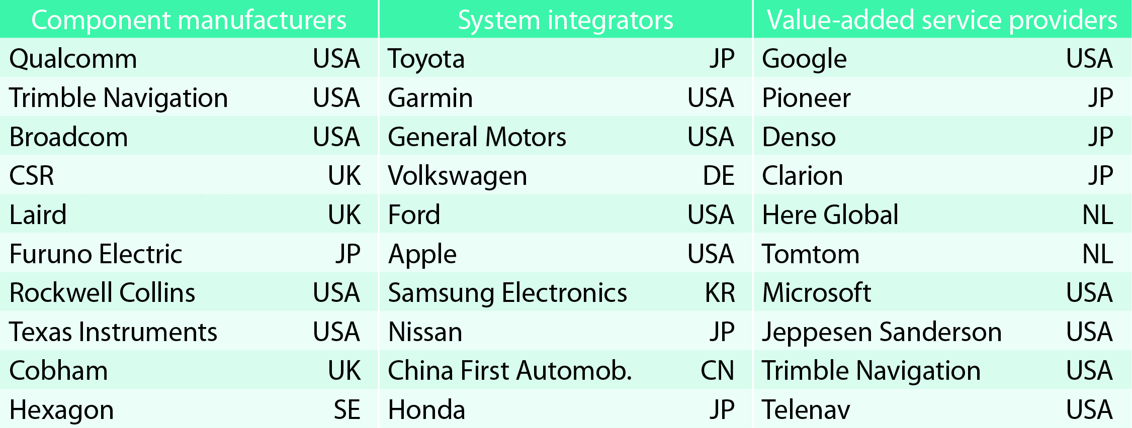
TABLE 1. Top 10 companies in each group based on 2012 revenue.
Key Findings
Top-line insights from the fourth GSA GNSS Market Report:
The global GNSS downstream market is forecast to increase by 8.3 percent annually from 2013– 2019, then slow down to 4.6 annually around 2023, growing on average faster (7 percent) than the forecast global GDP in this period (6.6 percent).
The installed base in the mature regions of EU28 and North America will grow steadily (8 percent per year) to 2023. The primary region of growth will be Asia-Pacific, which is forecast to grow 11 percent per year from 1.7 billion in 2014 to 4.2 billion devices in 2023 — more than the EU and North America together. The Middle East and Africa will grow at the fastest rate (19 percent per year), but starting from a lower base.
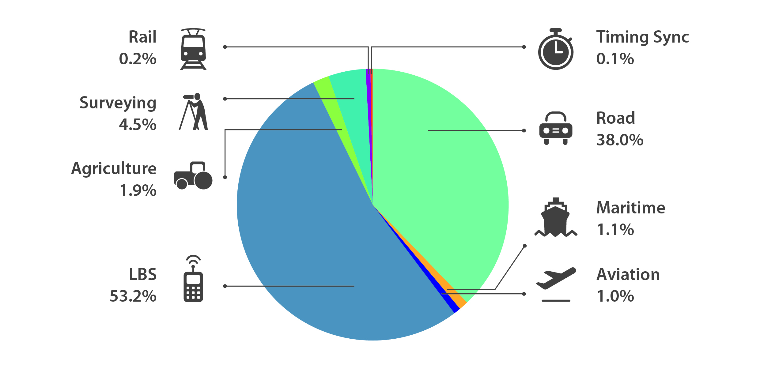
Location-Based Services (LBS) and Road dominate cumulative GNSS revenues, driven by booming sales of smartphones and in-vehicle devices, location-aware applications and data services.
With emerging economies catching up in terms of GNSS devices per capita, the Digital Divide will narrow, driven by the take-up of smartphones. The growing dominance of smartphones (3.08 billion in 2014) is foreseen as the most popular platform to access LBS.
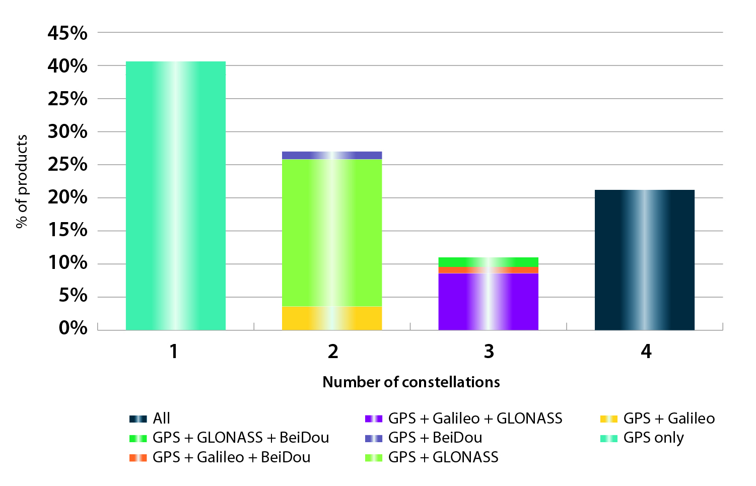
In the analysis of the capabilities of GNSS receivers and chipsets, it is reported that more than 60 percent of currently available receivers and chipsets support a minimum of two constellations with more than 20 percent supporting all four of them.
FIGURE 2. SUPPORTED CONSTELLATION BY RECEIVERS Chart shows the percentage of available receivers capable of tracking signals from one GNSS (such as GPS only), two GNSS (GPS + Galileo, GPS + GLONASS, GPS + BeiDou), three GNSS (GPS + Galileo + GLONASS, GPS + Galileo + BeiDou, GPS + GLONASS + BeiDou) or tracking signals from all constellations at the same time. The percentages add up to 100 percent. We can conclude that almost 60 percent of all available receivers, chipsets and modules are supporting a minimum of two constellations, showing that multi-constellation is becoming a standard feature across all market segments.
New Charts
The report includes new infographics presenting:
Global GNSS downstream market size, core and enabled (2013 to 2023)
GNSS industry share by region (2012)
The global shares of companies among components manufacturers, systems integrators and value-added service providers (2012)
Capability of GNSS receivers and chipsets, all segments (2015)
Supported constellation by receivers and chipsets , all segments (2015)
Detailed analysis of key GNSS segments: LBS, Road, Aviation, Rail, Maritime, Agriculture, Surveying, Timing and Synchronization, quantified in terms of:
Shipments of GNSS devices by application and region (2013 to 2023)
Installed base of GNSS devices by application and region (2013 to 2023)
Core revenues from GNSS device sales by application and region (2013 to 2023)
Capability of GNSS receivers and chipsets (2015)
Supported constellation by receivers and chipsets (2015).
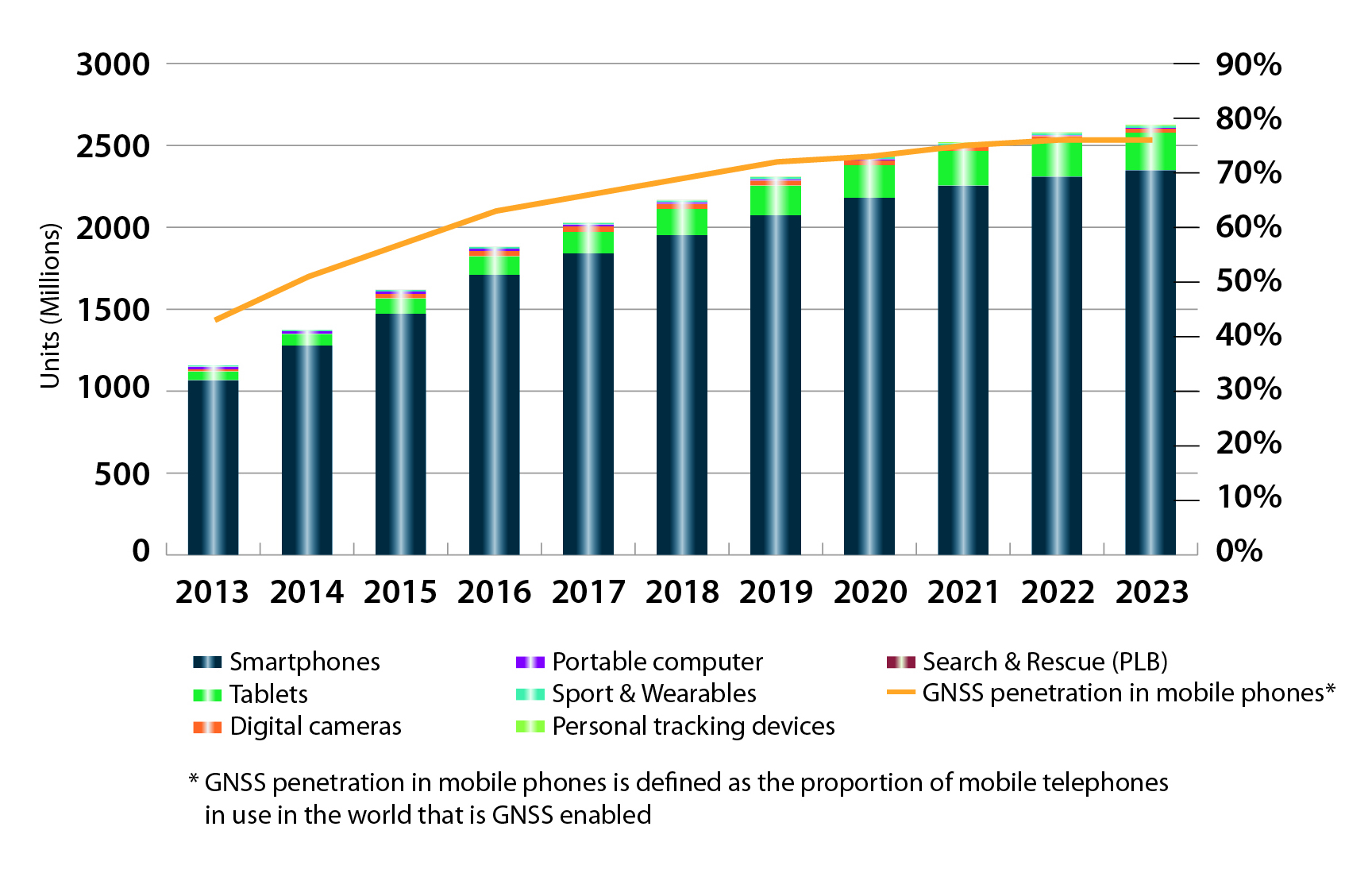
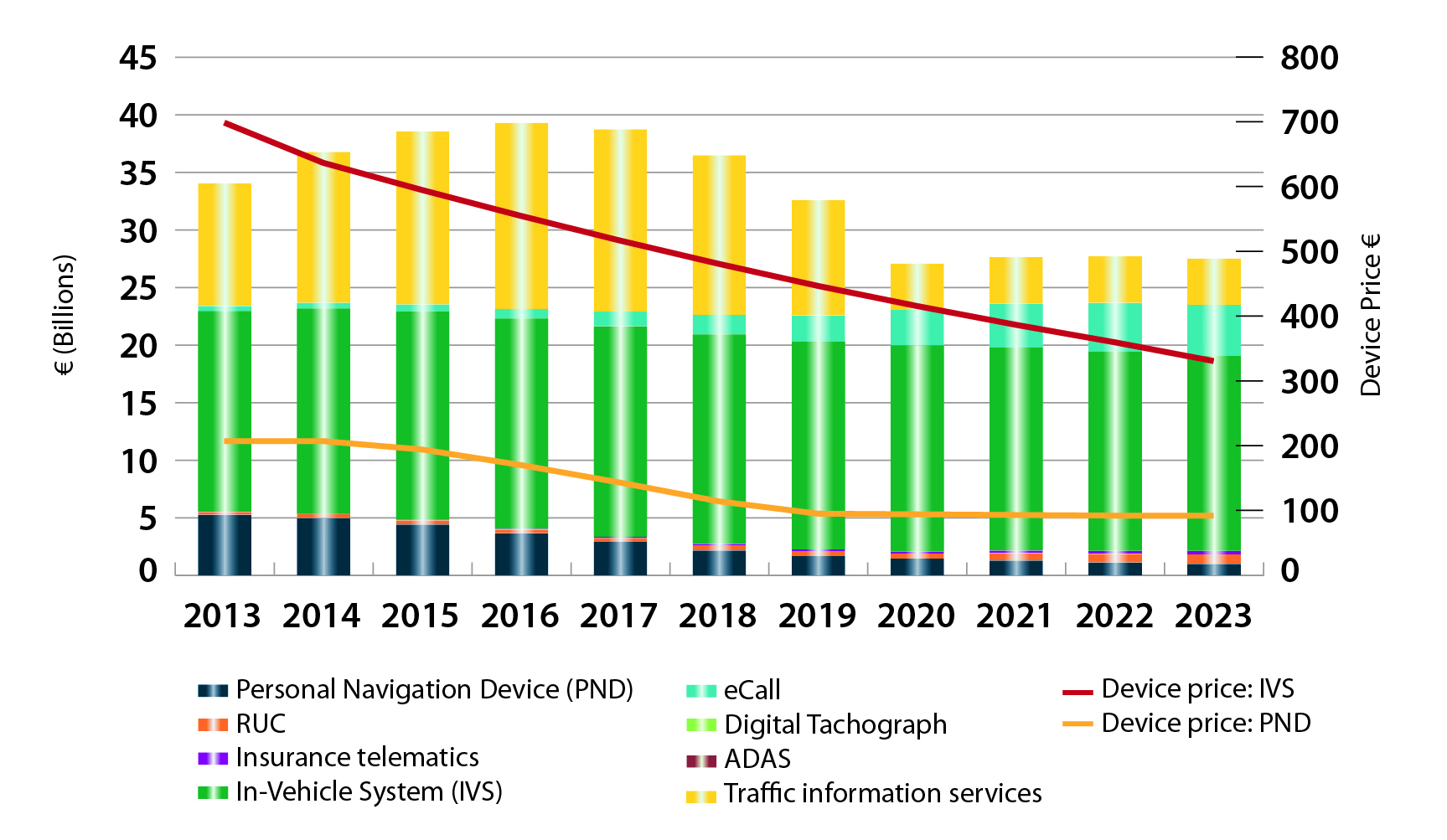
FIGURE 3. LOCATION-BASED SERVICES SECTOR GNSS shipments by type; GNSS penetration in mobile phones is defined as the proportion of mobile telephones in use in the world that is GNSS enabled.FIGURE 4. ROAD SECTOR Core revenue from GNSS device sales and services by application.
Methodology
The “GSA GNSS Market Report” is compiled by the GSA and the European Commission and was produced using the GSA’s systematic Marketing Monitoring and Forecasting Process.
The underlying market model uses advanced forecasting techniques applied to a wide range of input data, assumptions, and scenarios to forecast the size of the GNSS market in terms of shipments, revenue and installed base of receivers.
Historical values are anchored to actual data in order to ensure a high level of accuracy. Assumptions are provided by expert opinions and model results are cross-checked against the most recent market research reports from independent sources, before being validated through an iterative consultation process with sector experts and stakeholders.
In the report, the analysts have identified and deciphered the market dynamics in important GNSS industry segments, highlighting the areas offering promising possibilities for companies to boost their growth, according to Research and Markets. The report studies the market by sectors including location-based services (LBS), transportation (further divided into road navigation, rail navigation, air navigation and marine navigation), surveying and agriculture. The GNSS application market is further studied by region: North America, Europe, Asia-Pacific, and Rest of World.
The report provides a complete overview of the GNSS market globally. All the current trends and drivers, coupled with potential growth areas of the GNSS industry, have been evaluated in the report. Furthermore, the report provides information on opportunities in the industry for different companies in the chapter titled Opportunity Assessment.
Additionally, to provide an exhaustive knowledge of the prospects for GNSS players on the geographical front, the report provides comprehensive knowledge of the 10 most worthwhile GNSS markets around the world (U.S., Canada, UK, France, Germany, Russia, Japan, China, South Korea and India). It includes information about the present state and future outlook of the LBS and telematics markets in these countries along with information about their personal navigation systems such as GPS, BeiDou,Galileo, GLONASS, QZSS and IRNSS.
The report also looks into the competitive landscape covering business overviews, key financials, product analyses, recent developments and strengths and weaknesses of each of the players.
Key trends considered in the report include:
Driverless Car: New GNSS Technology Use
Indoor GNSS Positioning Poised for Growth
People, Pets and Thing Finder: The Next Attraction
GNSS Based Products: A Burgeoning Market Opportunity
Feedback Business Consulting has released a report on opportunity in the Indian GPS current market scenario, structure and practices.
The market scenario in “Opportunity in the Indian Global Positioning System (GPS) Market — 2015” includes current market size estimates by players, top companies, product categories, end user segments and regions. The product categories include tracking and navigation; segments include automobile, logistics, IT, ITe and mobile phones.
The market structure section details the value of key players’ presence across products and end user segments. The market practices section explores understanding the GPS market sets in business, market trends, distribution practices and pricing.
Some of the key companies featured in the report include Aadhithya Systems, Blaupunkt India, Caska India, Garmin India, Google Maps India and Locationguru.
The report also provides a snapshot of key competition and past market trends with a forecast over the next five years. Anticipated growth rates and the factors driving and impacting growth are also provided.
Market data and analytics have been derived from a combination of primary and secondary sources.
GPS World, the leading publication serving the GNSS Industry, is pleased to announce the industry’s first online buyers guide — gpsworldbuyersguide.com — featuring access to information on hundreds of manufacturers, products and services.
“We’ve taken the GPS World Buyers Guide in print, which we’ve been publishing for 20+ years, to an entirely new level,” said Alan Cameron, editorial director and group publisher of GPS World. “Adding a robust online version offers many benefits to the industry.”
Engineers, integrators, professional end-users and others in search of products and services will continue to have two resources available to them — the print Buyers Guide publishing in June — and the cutting-edge, robust version accessible 24/7 at: gpsworldbuyersguide.com.
Visitors can search for manufacturers by name or location. Products and services are searchable by name or via the following categories:
Vehicle location/tracing workstations and systems (computer-aided dispatch)
These categories are also searchable by sub-categories.
Manufacturers and suppliers are now in control of their listings year-round by having the ability to make listing updates in real time. Listings are free and numerous upgrades are available. Listings found at gpsworldbuyersguide.com will automatically be used to create the print version of the directory.
“GPS World’s new online product offers many economical ways for a manufacturer or supplier to enhance their exposure,” said Steve Copley, GPS World publisher. “We’re excited to offer an online element to our print product and provide a positive experience for users.”
Manufacturers and suppliers are encouraged to review their current listings by using the search functionality found on the directory’s home page. Manufacturers and suppliers not listed in directory are encouraged to create a new listing. All questions relating to the online directory should be directed to Chloe Kalin, Buyers Guide Marketing & Sales Manager, at 216-363-7929.
Tracking device maker Trackimo will make its official North American debut at a press conference on Jan. 7 during the 2015 Consumer Electronics Show in Las Vegas. At the press conference Trackimo will showcase its new line of tracking devices that will be introduced throughout 2015. Trackimo will also announce its partnership with Trackimo North America as an exclusive U.S. and Canadian distribution partner.
Trackimo was founded and is based in Israel. The company already has distribution deals in Latin America, Europe and Israel. The new distribution partnership in North America will offer its product to the mass market, according to Trackimo.
“We are very excited to be able to provide Trackimo’s cutting-edge technology at an entirely new price point that virtually sets a new mass market segment for tracking devices,” said Shai Bar-Lavi, CEO and Chairman of Trackimo, Inc. “We offer a whole new approach to tracking that enables consumers to use our products and services in ways that were not possible before.”
“We’re very excited to be part of the Trackimo Worldwide team and to be launching Trackimo into the North American market,” says Jim Prandine, vice president of sales, Trackimo North America. “Trackimo Universal covers dozens of applications in various channels, and our new upcoming products will broaden consumer demand even further.”
Bar Lavi added, “We are very excited about this new partnership with Trackimo North America as it opens up limitless opportunities for the Trackimo brand.”
Debuting at CES:
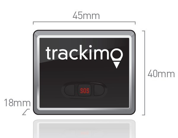
Trackimo Universal: A compact (45 x 18 x 40 millimeter), lightweight device with long-lasting battery life and worldwide service. Included accessories allow users to secure Trackimo device to different objects, including backpacks, bikes, belts and luggage. Trackimo Universal can also be hardwired in a car, eliminating the need for charging. Designed for outdoor use, the Trackimo device also includes accessories for waterproofing.
The Trackimo app offers a single-point login for both computers and mobile platforms to allow effortless management of tracking units. It offers multiple device management under a single account, as well as, a variety of remote settings options.
Highlights of Trackimo’s products include:
Dynamic Tracking Frequency: User-controlled location sampling enables optimized energy consumption.
Smart Alerts: User alerts via text, email and app notifications for location change, speed thresholds, sudden movement or impact, or SOS button press.
Dynamic History: All tracking history is stored; user can recall any time period and select from a variety of time resolutions.
GPS Tracking: Highly accurate locations when GPS reception available, but capable of accurate tracking wherever cell phone reception is available.
Virtual Fences: User-defined “geofences” give notifications when specific boundaries are crossed.
Multiple Devices: Multiple devices can be simultaneously tracked and managed on a single account.
Coming soon: Emergency Voice Channel: Voice channel can be opened automatically when SOS button is pressed, allowing remote user to hear what’s happening on site.
UAVs Revolutionizing Aviation: Exciting Challenges for the PNT Community
Sherman Lo, accepting Leadership Award from Mark Stewart.
Sherman Lo, Senior Research Engineer and Associate Investigator (APNT), Stanford University. One of the architects of eLoran and a worldwide thought leader on alternative PNT.
Remarks
I’m not very good at predicting the future but I know what is exciting to an aviation nerd like me — UAVs. I believe that unmanned autonomous vehicles will revolutionize aviation’s role in society.
UAVs have expanded the community of participants in aircraft development from solely the realm of large defense firms to individuals. The makers amongst us can fabricate custom parts for custom designs and order electric engines from across the sea. Our students have a class where they design and build sub-100-gram autonomous UAVs. They allow for rapid development and prototyping of technologies. All sorts of new crazy business models will be developed for their use.
This is significant for the PNT world because the proliferation of UAVs and what we are able to do with them is enabled by GNSS. That being said, for the good of the community, we also need to take steps to allow UAVs to fully realize their benefit to society. UAV navigation is a rich field.
Navigation improvements can significantly benefit UAV operations. For example:
A robust alternative navigation capability would continue to fly in case of GNSS loss.
An ability to authenticate the UAV’s location would be useful for delivery confirmation and other services.
The ability to range/sense/share information is needed for UAVs to collaboratively and safely use the airspace.
The solution may come in the form of using existing signals, new signals, inertial, vision, all of the above, or none of the above.
UAVs comes in all shapes and sizes, from the little one that our kids play with to the 10-kilogram octocopter in our lab, to even larger ones planned for package delivery to the Globalhawks, with wingspans larger than a 757’s, that I was fortunate to come face to face with at Edwards Air Force Base. There is no one-size-fits-all as UAVs are being developed in all shapes and sizes for many varied missions. I think that is a fun, interesting, and exciting challenge for the PNT community.
Introduced by…
Mark Stewart, Lockheed Martin VP of Navigation Systems, introduced the Satellite Leadership Award.
“I’ve been in the space business for 30 years, and I’m very honored to be part of this navigation community. One of our roles as technical leaders, all of us here, is to educate and coach the young engineers to take over this business as we move on.
“In that context, I reflect back on one of the tests that I had to take to enter college. One of the very simple questions, to start the test, was ‘Where does milk come from? A cow, a carton, a rock, or the moon?’ And I, being raised on a dairy farm in upstate New York, obviously circled cow. When we were graded, all of us received a letter back in the mail from the testing institution. It stated they were going to give credit for two answers, depending on where you came from. If you came from an inner city, in fact milk did come from a carton, so they gave credit for that.
“As an educator, I felt I wanted to go through my life educating people as to where things really come from. where they originate, and who to thank for those things they bring into our life.
“So, as a teaching moment here: the next test that comes up, probably in our children’s lives, will be ‘Where does GPS come from?’ One of the answers will be, undoubtedly, ‘a cell phone.’ Why do we need GPS when we have it in our cell phones, right? However, the correct answer is going to be — circle this — ‘All of you.’ We have GPS because of all of you in this room, the leadership you provide to your teams and all those team members we have back at home.
“So. I want to thank you all for being part of the GPS community and doing what you do so well, for the warfighter and for the civilian population as well. I thank you from the deepest part of my heart for what you do.
“I also want to thank all the award winners here tonight, and congratulations on their significant accomplishments.”
SATELLITES
Galileo’s Top Five for the Future: Accuracy, Robustness, Ephemerides, Time to First Fix, and Authentication
Javier Benedicto Ruiz
Javier Benedicto Ruiz, Galileo Project Manager, Directorate of Galileo Programme and Navigation-related Activities, European Space Agency. For directing a program that produced initial signal results better than the design specifications. (Accepted on his behalf by Marco Falcone, ESA’s Galileo System Manager).
Remarks
On behalf of Javier Benedicto, I would like to thank GPS World for this award. Javier feels really honored by this award you have decided to grant to the Galileo achievements of the last year. We are proud of what has been achieved, despite the difficulties — and believe me, we are very professional in addressing the difficulties in these days — we are fully determined to bring the Galileo system into full deployment, and the diverse services to GNSS users worldwide.
Javier wants to emphasize that the merit of our achievement is thanks to every single individual of an excellent team we have in the Galileo Project Office at the European Space Agency.
From a satellite system perspective, I will give a vision of the directions of the future from 2020 onwards. I have for you the Top Five issues that GNSS should address in the future.
Marco Falcone
The first one is better ranging accuracy, to a level of 10 to 15 centimeters. This would allow techniques to support more closely PPP instantaneous ambiguity resolution. For that, we need stable clocks and clock ensembles onboard.
Second, enhanced robustness and availability to reach PNT solutions everywhere. This can be done through signal-in-space encoding, interleaving, satellite diversity to be implemented not only at the level of the satellite systems, in fact I expect there will also be a lot of work to be done by receiver manufacturers to manage all these types of signals available from the different constellations.
Number three, long-term ephemerides with a validity up to one week, even up to 14 days. This is a very important point. How to achieve it? Through stable orbits without station-keeping, reducing station-keeping as much as possible, and highly stable clocks, like the new generation of hydrogen masers that we have onboard Galileo satellites at the moment.
Fourth, a faster time to first fix, up to one to two seconds for single/dual frequency users, using navigation message-aided information on top of ephemerides loaded with a duration up to 14 days.
Number five was discussed today by many papers in the conference: authentication, at the level of the navigation message, or at the level of ranging, with a clear identification of what will be the requirements of the future.
I have a bonus on top of the five: that is timing accuracy to a level of a service of 5 nanoseconds. I believe this is possible. We are already able today to reach up to 7 to 10 nanoseconds. This would allow at the end to have real-time universal time available to all users.
This is our message for the future. I thank you a lot for this award, for all the members of our great team.
Introduced by…
Lori Thompson
Exelis Geospatial Systems Vice President Lori Thompson helped introduce this year’s GPS World Leadership Award recipients at the dinner honoring engineers and scientists. Prior to the introductions, Thompson discussed the importance of innovation across the field of position, navigation, and timing, and the Exelis commitment to the ongoing advancement of timing and location technologies.
Exelis is on the Lockheed Martin GPS IIR & IIR-M team, which recently celebrated supporting the U.S. Air Force with 200 years of on-orbit success. Exelis is also supporting Lockheed Martin on the GPS III program, developing a new next-generation navigation payload.
“We take a great deal of pride in our core role with the Air Force GPS program,” Thompson said. “The Air Force mission is our mission. Ensuring the availability of the GPS signal to support day-to-day activities and critical operations is the reason Exelis continues to innovate in PNT.”
Thompson talked about the company’s ongoing initiatives to assure the GPS signal, specifically technology called Signal Sentry that helps detect and geolocate sources of interference.
SERVICES
High Precision in High Volumes: From a Circuit Card in a Handheld Computer to RTK in Your Mobile Phone
Eric Gakstatter, Contributing Editor for Survey and Geospatial Solutions, GPS World. For several widely read columns on what it will take to see large-scale consumer adoption of centimeter-accurate positioning.
Eric Gakstatter
Remarks
I have to say, I’m thoroughly embarrassed and deeply humbled to be up here. I’ve written about all of you or some of you at some time along the way, or at least the work that you’ve done.
I’d like to talk for a minute about history. I began my GPS career back in 1990. I was a 27-year-old product manager, and my boss came up to me and slapped a copy of GPS World magazine on my desk and said, “We need to do this.” It was a full page advertisement by Magnavox with a six-channel GPS engine, which was just a circuit card. We made handheld computers at that time. So we decided, hey, let’s take one of these boards and engineer it inside one of our handheld computers and make a data collector out of it for surveying and mapping.
I spent the next two years pretty much living at the office trying to make this happen. We ended up introducing some products, and several more after that. A few points of interest I recall:
I don’t know if Ron Hatch or Rich Keegan are here, but I remember running down to their office in Torrance and visiting with them about this whole concept; Tom Stansell was there at that time, too. Just to give you an indicator: the cost of that receiver board — I remember we paid $510 for a six-channel receiver, code and carrier, and I tell you the measurements on that receiver were tremendous back then. It’s really the basis, I think, for the WM101, which five years earlier was selling for $50,000 for a four-channel receiver.
So we get to today. I was listening to a panel this morning about low-cost, high-precision receivers, and a gentleman from China was talking about his prediction that at the year 2020, an RTK GNSS chipset would be about $20, and an RTK GNSS module about $100.
I tend to agree with him. I think it’s going in that direction. I’ve written a lot about, not necessarily the commoditization of high precision or RTK GNSS, but certainly a much wider audience for it. And if you watched that panel, you noticed that of all the people on that panel, he’s the one who talked about a broad audience: this high-precision GNSS making it, not maybe to the mass market, but certainly in the millions and maybe tens of millions of folks.
As far as predictions go, I think it’s just a matter of time before this happens. I appreciate what Todd Humphreys said a couple of years ago at this dinner, where he predicted RTK in your mobile phone by the year 2020. I’m onboard with that, and I’ll promote it as much as I can, and I hope that someone brings this to fruition. If it’s 2022 or 2021 or 2019, I think it’s just a matter of time before that happens.
Last, I’d just like to thank all of you for creating some great content and making it easy for me to write. Thank you.
Introduced by…
Matthew Gilligan
Matthew Gilligan, Raytheon Program Manager for the GPS Next Generation Operational Control System, introduced the Services Leadership Award.
“It is great to be here with men and women who understand the history and power of GPS, and it’s an honor for me to be here to help celebrate the GPS World Leadership Award winners.
“For the past 30 years, GPS has ensured weapons have found their targets, and ships at sea have returned to port. GPS has enabled the deployment of UAVs and has made sure that military missions of all kinds have been a success. GPS is a life-saving technology, ensuring soldiers come home safely.
“Today, GPS continues to grow in importance. Embedded sensors, mobile devices, and the interconnected technologies that are defining a new era of technology and our economy through the Internet of things — all enabled by GPS’s positioning, navigation and, so importantly, timing.
“To everyone in this room today, I want to say thank you for ensuring the mission evolves and continues.
“I have been asked to speak because I am leading Raytheon’s partnership with the Air Force in modernizing the ground segment — what we like to call the brains of GPS. My program, OCX, is at the core of the Air Force’s GPS modernization initiative. OCX will bring unprecedented new capabilities to GPS users worldwide:
enabling operational availability of all new civil and military signals,
protecting GPS against current and emerging cyber threats — setting the bar for information assurance at an unprecedented level,
improving system accuracy and integrity,
securely sharing information with net-connected users, and
providing flexibility and evolvability to meet future mission needs.
“OCX represents new approaches to emerging and even unimaginable changes and threats. And we are glad to recognize so many of you who are making it possible.
“We are excited to be here tonight with our partners, our customers, and even our competimates as we plan for and look forward to the future.”
PRODUCTS
Bringing SatNav Future into View: A Platform for Early Familiarization with New Constellations
Oliver Montenbruck
Oliver Montenbruck , Head, GNSS Technology and Navigation Group, DLR, German Space Operations Center. The principal driver behind the IGS Multi-GNSS Experiment project, whose free, real-time products could be a game changer for inexpensive multi-constellation RTK.
Remarks
Being selected for this prestigious award fills me with great pride and happiness, as well as deep gratitude. I would foremost like to thank you and GPS World, but also the unknown colleague who nominated me. However, it is the community that participated in the poll and ultimately selected me in this highly competitive contest. Thanks as well to all of you: your trust in my work and your recognition is truly appreciated!
Unfortunately, I can’t be here today to accept the award and to thank you in person, but have asked my colleague André to do so on my behalf. I’m presently staying in the Southern Hemisphere, which is not a fault of my GPS device, but was already planned some time before I learned about today’s event. Nevertheless, my thoughts are with you in Florida on this memorable evening.
I would like to elaborate a bit on the IGS Multi-GNSS Experiment, its background and status.
André Hauschild
The International GNSS Service, IGS, is a volunteer organization with more than 200 participating institutions worldwide. Over the past 20 years it has been the premier source of highest quality GNSS data, products, and related standards and conventions. There is hardly any student, engineer, or scientist in the field of GNSS that has not made use of IGS resources. Through its work, IGS supports a wide range of GNSS-related applications for the benefit of the scientific community and society as a whole.
The IGS has traditionally focused on GPS and GLONASS, but it is obvious that the world of GNSS is rapidly changing these days. With BeiDou, we already have a third operational satellite navigation system offering an at least regional service. Europe is actively pursuing the build-up of Galileo, which will offer another global navigation system with advanced performance features and new service types. And, last but not least, Japan and India are in good progress to establish QZSS and IRNSS as independent regional systems.
The new systems come with a multitude of new frequencies and a plethora of new signals. Industry has already done a great job, and nowadays offers a wide range of receivers and antennas for multi-frequency, multi-constellation tracking. However, we are only at the verge of making full use of the capabilities offered by the new GNSSs, and we still have a stony path ahead, before we can arrive at a “system of systems” as Günther Hein once phrased it.
In view of a rapidly changing GNSS landscape, the IGS decided three years ago to launch the Multi-GNSS Experiment, MGEX, as a platform for early familiarization with the new constellations. Within three years, the MGEX network has grown from zero to more than 100 globally distributed stations and presently supports tracking of all GNSSs with the sole exception of IRNSS. MGEX data have helped to gain experience and to characterize the new signals. They also served as a basis for pioneering work and various discoveries. The GPS L5 signal and CNAV navigation message, the Galileo high-performance hydrogen masers, and the BeiDou triple-frequency signals are just a few highlights that could be investigated in detail thanks to the MGEX network.
Building up on MGEX observations, a set of core products is now available for Galileo, BeiDou, and QZSS. These include precise orbit and clock solutions, differential code biases, as well as cumulative broadcast ephemerides. More products and a quality-control process will be implemented as we proceed and as we are able to gain new volunteers and workforce. All MGEX data and products are freely available to the community and will certainly form a starting point for excellent research and many Ph.D. theses at universities around the world.
It is a great honor for me to lead the MGEX project for more than two years now. Numerous achievements have already been made in that period, but we are also determined to make further progress as more and more satellites are launched and as we learn to better understand the “dirty details” of multi-GNSS processing. It has been a great pleasure to lead an experienced and highly motivated team, and it is actually they who should be awarded for their great work. I take this award today as an encouragement to pursue our work and to expand the IGS to a full featured Multi-GNSS Service for everyone’s benefit.
Thank you once more, and enjoy this fantastic evening.
Introduced by…
Ed Baron
Ed Baron, Director, Braxton Technologies, introduced and awarded the Products Leadership trophy.
“I’d like to thank Alan and his GPS World team for organizing this dinner allowing us to take the time to recognize tonight’s recipients.
“I have the good fortune to be here representing Braxton, a small business dedicated to delivering innovative capabilities on the GPS Program along with our partners; Lockheed, Exelis, and Raytheon.
“We are honored to help congratulate the recipients. This is a competitive area, and to be recognized in this field is a tremendous achievement. A strong ‘Well done!’ to every one of you.”
Satellite navigation has been at the forefront of technological developments. GPS, the most efficient and widely used satellite navigation system, is in the process of being upgraded by the technologically advanced satellites called GPS III. Once manufactured only by the U.S., satellite navigation systems are now being developed by other countries as well.
The IRNSS in India, Compass (BeiDou) in China, and Galileo in Europe are examples of systems that are either operational or are expected to be so in the next few years. These navigation systems are expected to create new opportunities in the GPS/GNSS market. The new navigation systems will require receivers’ and applications compatible with the new systems.
Although, Galileo is interoperable with GPS, it still would require new receivers and applications to complement the new system. China’s BeiDou is already partially in operation, and is expected to become fully operational by 2020. Countries such as Sri Lanka and Thailand are buying the system from China. The expansion in the use of the Chinese navigation system during the period 2015-2020 will involve military spending on COMPASS receivers both in the domestic market as well as the international market.
Topics covered include:
Introduction
Executive Summary
Global Military GPS/GNSS Market Size and Drivers
Industry Trends, Recent Developments and Challenges
According to a new market research report published by MarketsandMarkets, the total Yield Monitoring Devices and Services Market is expected to reach $2.51 Billion by 2020, growing at a CAGR of 7.17% from 2014 to 2020.
The report, “Yield Monitoring Devices and Services Market by Technology (GPS/GNSS, GIS, Remote Sensing), Components (Sensors, GPS/GNSS, Display, Guidance & Steering, and Software & Services), Application (VRA, Field Mapping, Soil Monitoring, and Scouting), and Geography – Global Forecasts to 2020”, is available now. It includes 65 market data tables and 64 figures spread through 208 pages and an in-depth TOC.
Yield monitoring is considered by farmers to be essential as yield data is recorded automatically while harvesting crops. Yield monitoring and mapping offers many other on-farm and off-farm benefits such as real-time availability of information, creation of a spatial database, and evaluation of whole-field improvements. Yield monitoring devices and services are implemented for site-specific farming, which ensures better efficiency, high yield, and profitability with optimum usage of resources. Yield monitoring techniques have major applications in variable rate application (VRA), soil monitoring, field mapping, and crop scouting.
Despite the rapid growth of global commerce and the widespread availability of equipment for yield monitoring and VRA, adoption rates appear to differ sharply from one country to another. The increasing demand for food is propelling the growers to adopt yield monitoring techniques and optimize their resources efficiently with minimum wastages.
The report provides a detailed segmentation by technology, component, and application. The geographic analysis covers all existing and emerging technologies in the yield monitoring devices and services market. The market based on technology is segmented into guidance system and remote sensing. The market based on hardware components and software is segmented into hardware components such as sensors, GPS/GNSS devices, display devices, guidance, and steering; and software services such as yield data management software as well as consulting and training services. The report also covers major applications of yield monitoring techniques such as field mapping, VRA, soil monitoring, and crop scouting with qualitative and quantitative industry insights.
One of the objectives of the report is to analyze market trends for each of the Yield Monitoring Devices and Services Market segments and their respective growth rates. Apart from market segmentation, the report also covers an in-depth analysis such as Porter’s five force analysis, supply chain with a detailed process flow diagram, and market dynamics such as drivers, restraints, and opportunities for this market.
A new market research report by WhaTech examines the global and Chinese GNSS industry, covering the decade 2009-2019. The report “Discover latest trends in Global and Chinese GNSS system industry, 2009-2019” analyzes quantitatively the global and Chinese GNSS market of 2009-2014 by calculating the main economic parameters of each company. The data is broken down by company, country, and application. The report also estimates future market development in the coming period of 2014-2019.
In its first segment, the report reviews basic GNSS information including its classification, application and manufacturing technology. It then explores top global and Chinese manufacturers of GNSS systems, listing their product specification, capacity, production value, and market share. The report then analyzes the upstream raw materials, downstream clients, and current market dynamics of the GNSS industry.
The report concludes with proposals for a new GNSS industry project before evaluating its feasibility. Overall, the report provides an in-depth insight to the global and China GNSS industry covering important parameters, according to WhaTech.
Table Of Contents
Chapter One: Introduction of GNSS System Industry
Chapter Two: Manufacturing Technology of GNSS System
Chapter Three: Analysis of Global Key Manufacturers (Including Company Profile, Product Specification, 2009-2014 Production Information etc.)
Chapter Four: 2009-2014 Global and China Market of GNSS System
Chapter Five: Market Status of GNSS System Industry
Chapter Six: Market Forecast of 2014-2019 Global and China GNSS System Industry
Chapter Seven: Analysis of GNSS System Industry Chain
Chapter Eight: Global and China Economic Impact on GNSS System Industry
Chapter Nine: Market Dynamics and Policy of GNSS System Industry
NovAtel, Inc.’s Calgary facility has been awarded the prestigious 2014 Manufacturing Excellence Award from the Association for Manufacturing Excellence (AME). The award acknowledges North American facilities that have demonstrated excellence in manufacturing and business, and recognizes NovAtel’s dedication to continuous improvement, best practices, creativity and innovation.
A representative of the AME presented the award to NovAtel at the company’s Calgary headquarters on October 23. NovAtel will also be recognized at the 2014 AME International Excellence Inside Conference, November 10-14 in Jacksonville, Florida.
NovAtel Inc. designs and manufactures high-precision, OEM, global positioning products and employs more than 400 people.
During their evaluation, the AME assessment team highlighted NovAtel’s work culture, observing that improvement systems were evident throughout the organization. They also praised the company’s commitment to creating a continuous improvement culture and systems. The assessment team remarked, “NovAtel leadership and plant employees can be proud of the site’s manufacturing excellence achievements to date.”
“We are very proud to receive an award which recognizes NovAtel as a leader in Enterprise Excellence in North America,” said Michael Ritter, president and CEO of NovAtel. “Fostering a culture of innovation, excellence and continuous improvement, in all aspects of our business, is something we strive for every day.”
Ritter added, “Our lean manufacturing initiatives are just one of the many ways we strive to add value for our customers. Making data-driven decisions in combination with fostering employee teamwork, mutual respect and accountability, throughout all levels of our organization, is essential to our long-term success in a global marketplace.”
“This award confirms that we are indeed on the right path 11 years into our ‘Lean’ journey,” said Mike McAloney, VP Operations for NovAtel. “We view ‘Lean and Continuous Improvement’ initiatives as the foundations of the operational excellence that lets us achieve our corporate mission: to generate customer success by providing precise positioning and augmentation technologies that are easy to integrate and provide exceptional return on investment.”


 GPS World, the leading publication serving the GNSS Industry, is pleased to announce the industry’s first online buyers guide —