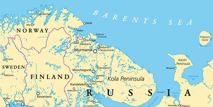
For Norway, frequent GNSS jamming and spoofing is affecting a wide range of civilian operations, including air traffic. Interference is increasingly being detected deeper inside Norwegian airspace, reports the Barents Observer.
Three dedicated monitoring stations for detecting GNSS disturbances have already been established in the region bordering Russia. Now, the Norwegian Communications Authority (Nkom) plans to install two additional stations this year.
The new sensors will provide improved continuous monitoring, covering key new areas, including large parts of the Varanger Peninsula and the Barents Sea.
The Secure World Foundation’s annual report, “Global Counterspace Capabilities: An Open Source Assessment,” is now available.
The 2026 edition compiles and assesses publicly available information on counterspace capabilities being developed by 13 countries across five categories: co-orbital, direct-ascent, electronic warfare, directed energy and cyber.
The report discusses jamming against GNSS and other position, navigation and timing (PNT) satellites. It assesses current and near-term future capabilities for each country, along with their potential military utility, and discusses their space situational awareness capabilities.
Countries covered in this report are: the United States, Russia, China, India, Australia, France, Germany (added this year), Iran, Israel, Japan, North Korea, South Korea, and the United Kingdom.
The European Union Aviation Safety Agency (EASA) and EuroControl have published a joint action plan designed to strengthen the safety and resilience of European aviation operations amid the growing challenge of GNSS interference.
GNSS provides aircraft with precise positioning, navigation and timing information that is essential for a wide range of functions. Interference with the signals has become a regular occurrence, in particular on the edge of conflict zones, and poses a threat to safety. The action plan focuses on maintaining safety in the near term while limiting impacts on airspace capacity and containing the threat of GNSS interference. It sets out short, mid- and long-term measures to mitigate the threat with harmonized operational procedures and to strengthen the robustness of GNSS‑based operations by clearly defining who needs to act, and by when.
“While the potential threat to aviation safety from GNSS interference has so far been mitigated by short-term actions such as raising pilot awareness, it is clear that more needs to be done,” said Florian Guillermet, EASA executive director. “This action plan lays out and prioritizes short, mid and longer-term actions and, importantly, also assigns roles to the various aviation actors. By working together with EuroControl and pooling our expertise, we have been able to create a strong plan that will enable the wider sector to come together to counter this threat.”
“GNSS interference remains a significant and evolving challenge for European aviation, making today’s action plan an important step forward in our collective response,” said Raúl Medina, director-general, EuroControl. “The action plan concretely supports our Member States and aviation partners as we work together to ensure the evolution and resilience of aviation’s critical infrastructure — one of the core goals of EuroControl’s Trajectory 2030 strategy. I welcome the strong cooperation and close coordination with EASA and all our partners across the aviation sector on this plan, which demonstrates our shared commitment to safety, and aims at delivering tangible benefits for the network, operators and passengers by making GNSS‑based operations more robust.”
Key elements of the joint action plan The action plan is built on several core pillars designed to strengthen Europe’s ability to detect, manage and mitigate GNSS interference.
Through joint monitoring and data-sharing, EASA and EuroControl aim to establish a common, validated operational picture of GNSS interference events across Europe, enabling more accurate detection, reporting and situational awareness. By pooling expertise and operational data, the two organisations will deepen their understanding of interference patterns, operational impacts and associated safety risks, with the aim of delivering consistent and harmonized guidance to air navigation service providers (ANSPs), airlines, and national authorities to ensure rapid and aligned responses to interference incidents.
In close partnership, EASA and EuroControl will develop updated operational guidance for flight crews and air traffic controllers to help them manage disruptions effectively and maintain safe operations in degraded navigation environments and join forces and expertise for investigations into ongoing GNSS interference. The two organisations will also promote improved mechanisms for timely information exchange through Member States, ensuring that events with both civil and military dimensions are addressed in a coordinated and transparent manner to minimize disruption and preserve airspace capacity.
The action plan envisages close collaboration with A/C manufacturer and avionics industry to support the development of more robust, interference‑resilient avionics solutions over the longer term. It addresses the concerns expressed in a letter sent on June 6, 2025, by 13 EU Member States to the European Commission that called for immediate and coordinated European action to address the growing number of Radio Frequency Interference (RFI) events affecting GNSS‑based systems. The action plan also integrates proposals and guidance from international partners including the International Civil Aviation Organization (ICAO), and the International Air Transport Association (IATA).
Background GNSS enables more efficient flight paths, reduces fuel consumption, and supports the implementation of Performance-Based Navigation (PBN), which allows aircraft to fly more direct routes and operate safely in areas with limited ground-based infrastructure.
However, the growing challenge of RFI — whether intentional (jamming or spoofing) or unintentional — poses a threat to the resilience of these systems. The most severe interference typically occurs near conflict zones, but GNSS performance may be affected well beyond these areas. Although aircraft can operate safely without GNSS, disruptions can reduce resilience and the continuity of operations.
The UK Royal Institute of Navigation has released a special report on GNSS-interference and its impact on the maritime sector.
Impacts of GNSS Interference on Maritime Safety is a special report by the RIN Maritime GNSS Interference Working Group on the impacts of GNSS Interference. Survey data was compiled from more than 100 sector experts and 300 vessel captains, supported by interviews with dozens of people involved in the operations and supply chain of vessels that regularly encounter GNSS interference.
GNSS interference refers to anything that disrupts a ship’s satellite-based positioning signals, usually caused by jamming and spoofing.
In 2025, at least two collisions and groundings were reported in mainstream media linked to GNSS interference in regions such as the Baltics, Straits of Hormuz and the Red Sea. With hundreds of vessels being affected daily, the RIN report details for the first time the scale of the problem on modern digital vessels, where GNSS jamming and spoofing present a significant cybersecurity vulnerability and urgent risks to maritime safety.
Survey data exposes the vulnerability of critically important systems such as Global Maritime Distress and Safety Systems (GMDSS) and other SOLAS-mandated equipment that rely on satellite positioning and timing.
“The report has highlighted serious safety concerns and has underlined the fact that these issues are rooted in significant cybersecurity vulnerabilities, and are not just disruptions to navigation,” said Ramsey Faragher, director of the RIN.
Operating within regions of known GNSS interference carries serious safety-of-life and liability implications, as key systems are expected to fail or malfunction with high probability in these conditions. The report also highlights unnecessary dependencies between GNSS receivers and a range of onboard electronics — including radar, radios (VHF/MF/HF), Navtex, speed logs, ship clocks and satellite communications — many of which do not require GNSS data for their primary function, creating avoidable points of failure and compounding operational risk.
“The issue of GNSS interference must be taken seriously. It cannot be overcome by traditional navigation techniques when GNSS receivers are ‘baked in’ to modern ships’ critical systems, including safety systems,” said Ivana-Maria Carrioni-Burnett, maritime captain and chair of the RIN Maritime Navigation Group. “These are no longer isolated incidents and pose a real risk to life: people, property and the environment. We must do more to safeguard our seas today and the shipping of tomorrow.”
“Despite measures to improve resistance to jamming, spoofing and other harassment measures, the threat is real and growing,” said Retired Commodore James Taylor OBE and fellow of the RIN advises. “And this threat is not only to positioning and navigation; it is to every part of every transport and navigation means and to every part of national infrastructure where timing is derived from space-based timing signals.”
The Royal Institute of Navigation will continue to work with report partners (GLA, IALA, Nautical Institute and others) and regulatory bodies to provide expert guidance to mitigate these issues, and to establish industry-wide adoption of solutions to this problem. RIN thanks National PNT Office for its support.
The Coastal States of the Baltic Sea and the North Sea have published an open letter to the international maritime community insisting on the protection of GNSS-based navigtion. The countries point the finger squarely at the Russian Federation for causing disruption in both critical navigation and timing services for sea vessels.
“Modern maritime transport is fundamentally built on the reliability of satellite-based navigation,” reads the letter. “For over three decades, global shipping has advanced by developing vessel operations to increasingly depend on the position, timing and navigation data provided by satellite systems. This shift has brought great efficiency but has also created a new dependency.
The letter highlights the importance of GNSS as a critical safety requirement, not only ship navigation but also precise time synchronization vital for systems such as the Global Maritime Distress and Safety System (GMDSS).
Risks to the Automatic Identification System
Another GNSS service, the Automatic Identification System (AIS), plays a key role in traffic coordination, situational awareness and emergency response. “Spoofing or falsifying AIS data undermines maritime safety and security, increases the risk of accidents, and severely hampers rescue operations,” the letter states.
“We are now facing new emerging safety situations due to growing GNSS interference in European waters, particularly in the Baltic Sea region. These disturbances, originating from the Russian Federation, degrade the safety of international shipping. All vessels are at risk.”
The countries ask for cooperation developing alternative terrestrial radionavigation systems as a GNSS backup. They also want vessels crews properly trained to operate safely during navigation system outages.
“Maintaining trust in maritime navigation requires more than technology – it demands responsibility, transparency, and decisive action,” the letter states. “We must ensure that our seas remain safe, including when systems fail or face disturbances.”
The International Air Transport Association (IATA) has called for vigilance following the increasing number of GNSS spoofing and jamming incidents worldwide. The growing interference poses a significant risk to flight navigation and pilot safety.
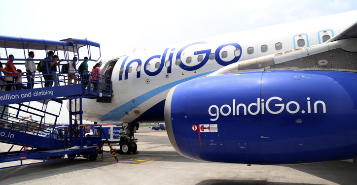
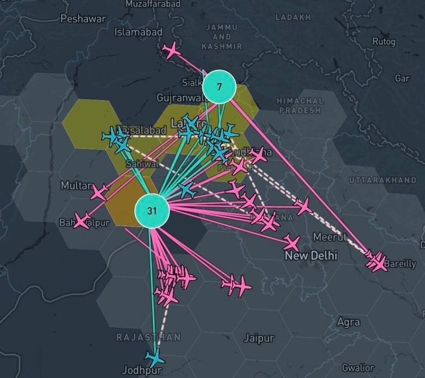
Of note is a spike in incidents at major Indian airports. Almost 2,000 GNSS interference incidents have been logged at airports in India since 2023, including the airports in Delhi, Mumbai, Kolkata, Amritsar, Hyderabad, Bengaluru and Chennai.
IATA represents more than 360 airlines, accounting for 80% of global air traffic. Indian carriers Air India, IndiGo, Air India Express and SpiceJet are members.
“GPS spoofing and jamming incidents are increasing rapidly across the world,” said IATA Director General Willie Walsh, speaking at an industry event in Geneva. “This is not merely a technical concern — it’s an operational vigilance issue for pilots.”
Walsh noted a higher frequency of interference events, expanding well beyond conflict zones and affecting global civil aviation routes.
India’s Civil Aviation Ministry informed Parliament that between November 2023 and November 2025, a total of 1,951 GNSS interference cases were reported. The data collection began after the Directorate General of Civil Aviation (DGCA) issued an advisory circular in November 2023, mandating airlines to report all GNSS-related disruptions.
Shipborne Measurements Near the Kaliningrad Border
A major new report by GPSPATRON gathered data between June 23 and Oct. 14, aboard a vessel routinely leaving the Port of Gdańsk and performing extended maneuvers in open water.
The vessel conducted multiple offshore measurement campaigns, resulting in a shipborne dataset that provides a far more accurate representation of the true GNSS environment experienced by maritime operators in the Gulf of Gdańsk. It also reveals a level of interference complexity and intensity not visible in a previous coastal study.
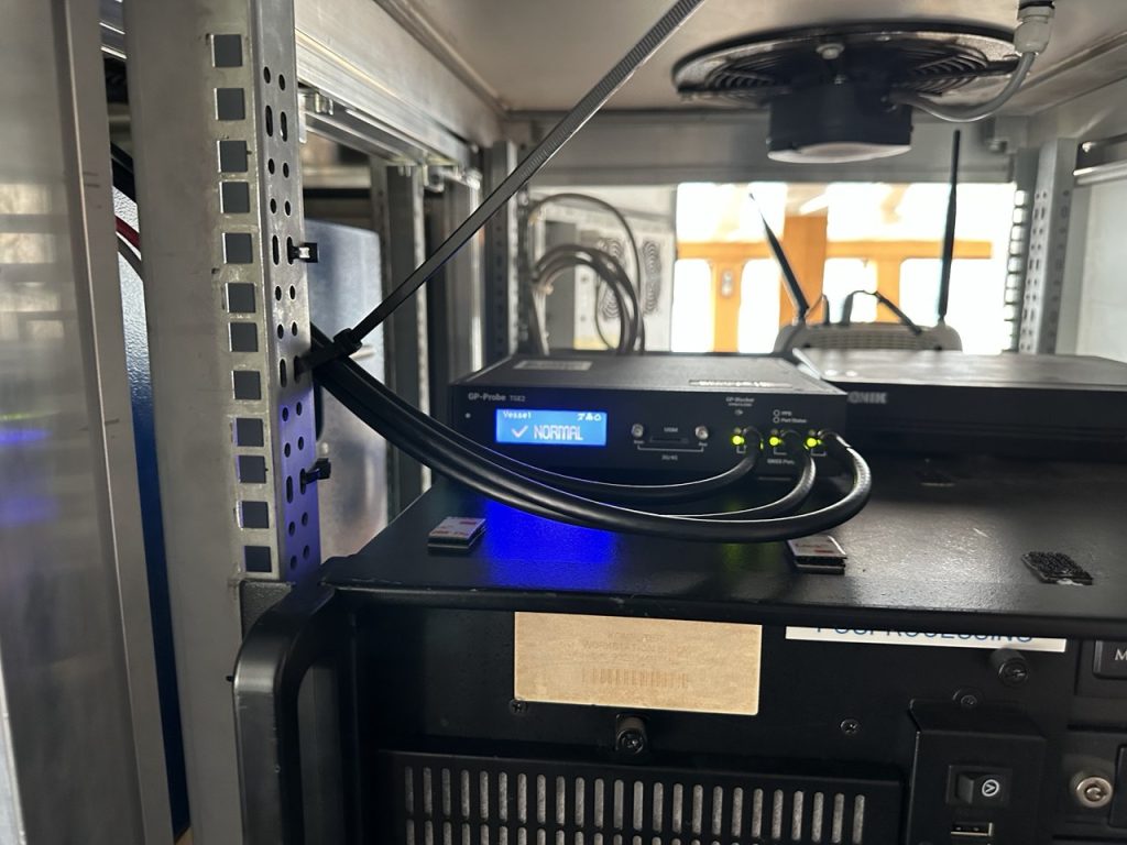
In the present phase of research, the GPSPatron team moved beyond land-based monitoring and installed itsGP-Probe TGE2 interference sensor directly on board a research vessel. The ship operated throughout the southern Baltic Sea, including regular approaches toward the maritime boundary of the Kaliningrad region.
By placing the sensor on a moving platform rather than a coastal location, they were able to record GNSS interference exactly as it affects real vessels — capturing signal conditions that cannot be observed from shore due to differences in radio horizon, antenna orientation, multipath environment, and proximity to potential interference sources.
The GPSPATRON probe TGE2 instaslled within the vessel’s equipment. (Photo: GPSPATRON)
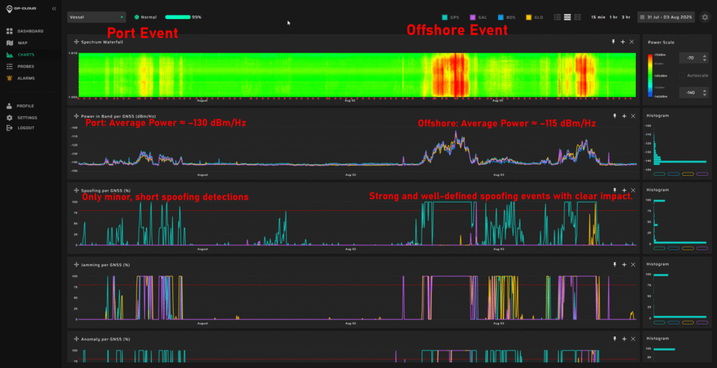
Transition from classical jamming to combined spoofing-jamming interference
In contrast to the previous six-month coastal study, where all recorded GNSS interference consisted exclusively of multi-constellation jamming, the current shipborne campaign reveals a fundamentally different interference landscape.
All major events now present a dual-layer structure composed of:
GPS L1 spoofing, generating forged satellite-like signals, and
Simultaneous jamming of GLONASS, Galileo, and BeiDou.
This combined architecture forces GNSS receivers to rely solely on spoofed GPS signals while denying access to independent ranging sources. The practice is consistent with commonly used operational strategies: spoofing only one constellation (GPS) drastically reduces system complexity and cost, whereas spoofing all GNSS systems would require multiple parallel RF chains, SDR-based generators, algorithms for signal simulations and amplifiers.
Highest recorded levels of GNSS disruption
The most severe interference period occurred from late June through July, during which:
GNSS availability dropped to 83.5%,
4 days, 5 hours and 24 minutes of spoofing were recorded — by far the highest cumulative spoofing activity of the entire campaign.
The single most extreme incident took place between 1 and 3 July, with nearly 30 consecutive hours of spoofing within a 48-hour interval, posing a severe risk for maritime navigation.
In subsequent months the interference intensity gradually decreased, yet low-power and short-duration events continued to be observed.
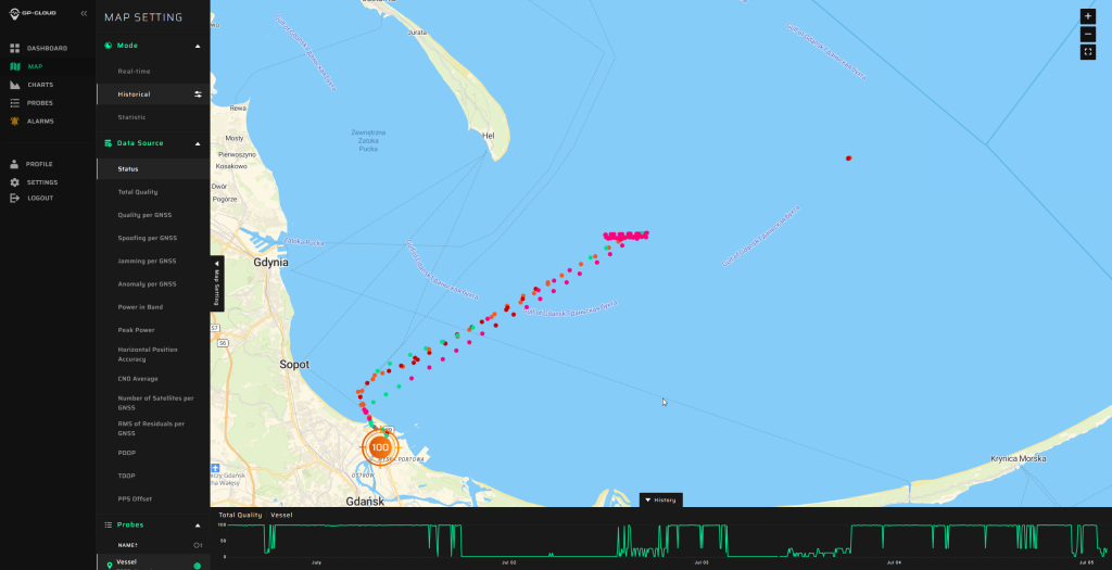
The area of the Baltic Sea the vessel patroled for GNSS interference. (Image: GPSPATRON)
A multi-emitter, synchronously operating interference network
Spectrogram analysis reveals that the interference does not originate from a single source but from four distinct, technologically different emitters operating in coordination:
The synchronous activation and termination of all four components indicate a centrally coordinated system, yet their differing spectral signatures, bandwidths, and stability levels confirm multiple spatially separated stations rather than a single unified installation.
This GNSS interference analysis shows interference intensity increases away from port. (Image: GPSPATRON)
Evolution of interference modulation techniques
A clear shift is observed compared to the previous study :
Previously, the dominant interference source consisted of a high-quality, purpose-engineered wideband signal with three clean constellation-matched components — an indication of modern, precisely designed jamming equipment.
In the current campaign, the prevailing interference is simpler wideband chirp jamming, a less advanced technique but deployed at significantly higher power levels.
The wideband analog-like component further shows pronounced parasitic frequency fluctuations, characteristic of older low-stability RF hardware.
This indicates a shift from high-precision jamming to a mixed environment of legacy high-power systems combined with newer spoofing capabilities.
Interference strongly intensifies offshore
A distinct spatial gradient was recorded:
In the Port of Gdańsk, interference appears weak or barely detectable.
As the vessel moves into open water, the same signals become up to 15 dB stronger.
The interference power consistently increases when approaching the waters facing Kaliningrad.
This pattern shows that — intentionally or not — the interference system affects maritime traffic far more than coastal infrastructure, with the operational impact being greatest in offshore navigational zones.
Download the full report using the form on this page.
India’s Directorate General of Civil Aviation (DGCA) has issued an adendum on reporting procedures for suspected GNSS spoofing, reports news service AIN. On Nov. 10, the DGCA began requiring that all spoofing and jamming incidents be reported within 10 minutes, following an intense period of disruptions around Indira Gandhi International Airport in Delhi.
The addendum is meant to clarify exactly what pilots and operators are required to do both before and after a GNSS interference incident is suspected.
The disruptions produced false EGPWS alerts, position errors, and incorrect altitude indications, according to OpsGroup. The interference briefly drove ADS-B integrity in the Delhi terminal area to zero, affecting hundreds of aircraft and leaving controllers unable to rely on GPS-based surveillance.
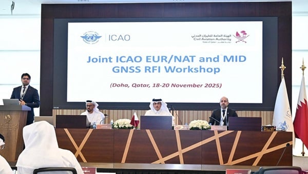
The Qatar Civil Aviation Authority (QCAA) this week is hosting the Joint ICAO Europe and North Atlantic (EUR/NAT) and Middle East (MID) Workshop on GNSS Radio Frequency Interference, reports the Qatar News Agency.
The workshop is organized jointly by the ICAO EUR/NAT and MID Regional Offices and is being held in Doha, Qatar, Nov.18-20.
In the opening session, Mohamed bin Faleh Al Hajri, QCAA manager, reaffirmed Qatar’s commitment to enhancing aviation safety and efficiency through close collaboration with ICAO and regional partners.
The workshop brings together countries and stakeholders from the EUR/NAT and MID regions to address the increasing threat that GNSS radio frequency interference poses to aviation safety and efficiency. Al Hajri emphasized the importance of active participation to exchange experiences, strengthen cooperation, and build sustainable partnerships that support GNSS resilience.
He highlighted that hosting the workshop reflects joint efforts aimed at strengthening the robustness and reliability of GNSS — a core pillar in ensuring the safety and efficiency of international air navigation.
Regional dialogue
The workshop aims to:
facilitate regional dialogue on the operational impact of GNSS radio frequency interference
share experiences among participating States and stakeholders
explore measures to improve reporting mechanisms, enhance mitigation strategies, and strengthen the overall resilience of satellite-based navigation systems.
It also seeks to reinforce cooperation between the EUR/NAT and MID Regions to safeguard the infrastructure and integrity of GNSS-based navigation systems.
The Royal Institute of Navigation (RIN) Maritime Working Group is investigating GNSS jamming and spoofing in the maritime sector, starting with a survey. The survey is “aimed at anyone in the maritime sector who has experienced GNSS interference and who can provide us with further information on the impact that it is having,” the group stated.
Interference have been pervasive for years now in areas such as the Baltic Sea and the Black Sea. In the Strait of Hormuz alone, almost 1,000 ships per day experience GNSS interference, impacting crew safety and the security of their cargo. Collisions and groundings are a very real threat, with the Frontier Eagle and MSC Antonia accidents being the most recent examples.
The RIN will be producing a report similar to the September 2024 OPSGROUP report that focused on GPS spoofing in the aviation sector.
The UK Royal Navy‘s Disruptive Capabilities and Technologies Office (DCTO) recently teamed up with scientists from the University of Sussex to test new navigation sensors developed to reduce reliance on GPS navigation.
The ultra-sensitive quantum sensors measure tiny variations in the Earth’s magnetic field, offering a new way to pinpoint locations when satellite signals are jammed or unavailable.
“We are excited and pleased to have supported this first sea trial with the University of Sussex and its quantum magnetometer technology,” said Commander Matt Steele, from DCTO. “We are also grateful to our colleagues in the Hydrographic Exploitation Group for providing one of its vessels and crew to provide a test platform.
“To ensure it can resiliently operate in GNSS-denied and degraded environments, the Royal Navy continues to explore and accelerate the development of alternative means of navigation, such as this magnetic sensor, while positioning itself as a pioneer ‘quantum-enhanced navy’.”
“GPS or GNSS signals are highly vulnerable to disruption: they can be jammed or spoofed, and they fail entirely underground, underwater, or in heavily obstructed environments,” said Tom Coussens, Research Fellow in Quantum Science and Technology at the University of Sussex. “This vulnerability has serious economic and operational consequences. While alternative systems such as inertial navigation and visual recognition exist, none simultaneously meet all critical requirements: long-term positional accuracy, weather independence, and resistance to jamming.”
In the trials, a team from the university worked with the Royal Navy’s Hydrographic Exploitation Group who survey waters, recording details of depth, seabed objects and composition. The university used its Optically Pumped Magnetometers in open waters, with the trials taking place from His Majesty’s Naval Base Portsmouth.
In addition to navigation, they also successfully mapped surrounding magnetic signatures, pointing to new methods for detecting vessels, undersea features, and potential hazards.
Honeywell has launched the Honeywell Alternative Navigation Architecture (HANA) — a software-based solution designed to ensure resilient navigation for crewed and uncrewed aircraft, as well as military surface vehicles, in environments where GNSS signals are degraded, jammed or spoofed.
“Due to the proliferation of low-cost tools, the number of jamming, spoofing and blocking incidents is growing and is leaving more pilots and operators in the air without access to GNSS data,” said Matt Picchetti, vice president, Navigation and Sensors, Honeywell Aerospace Technologies. “HANA is our latest alternative navigation system designed to counter these threats by providing precise information on the aircraft’s position, velocity and orientation when GNSS signals are unavailable.”
HANA is a multi-system navigation platform that includes:
Vision-aided navigation. Using live camera feeds to match ground imagery with map databases.
Magnetic anomaly-aided navigation. Detecting known variations in Earth’s magnetic field.
Low Earth Orbit (LEO) satellite navigation. Offering stronger, lower altitude signals more resistant to jamming..
Other modalities. Including light detection and ranging (lidar), radar, radios and star trackers.
Photo: Honeywell Aerospace
With this layered architecture, operators can mix and match modalities to meet mission-specific requirements, ensuring maximum resilience, system integrity and signal availability even in GPS-denied environments. To ensure efficiency and ease of use, HANA can run on the operator’s current computing platform or one that Honeywell provides.
Initial release of HANA includes vision-aided navigation. Honeywell also plans to integrate magnetic anomaly and LEO satellite solutions into the platform in 2026.
HANA’s launch marks a major milestone in Honeywell’s five-decade legacy of inertial navigation system innovation, reinforcing its leadership in aerospace navigation and its commitment to mission-critical resilience for defense and commercial aviation.