The International Air Transport Association (IATA) and the European Union Aviation Safety Agency (EASA) have published a comprehensive plan to mitigate the risks stemming from GNSS interference. The plan was among the conclusions of a jointly hosted workshop on the topic of GNSS interference.
Given the continued rise in frequency of interference with GNSS signals, the workshop concluded that a broader and more coordinated approach is needed. focusing on four key areas: improved information gathering, stronger prevention and mitigation measures, more effective use of infrastructure and airspace management, and enhanced coordination and preparedness among relevant agencies.
Reported incidents of interference with GNSS signals have been increasing across Eastern Europe and the Middle East in recent years. Similar incidents have been reported in other locations globally. The initial response focused only on containing those GNSS interference incidents.
“GNSS disruptions are evolving in terms of both frequency and complexity,” said Jesper Rasmussen, EASA Flight Standards director. “We are no longer just containing GNSS interference — we must build resilience. The evolving nature of the threat demands a dynamic and ambitious action plan. Through collaboration with partners in the European Union and IATA, and by supporting the International Civil Aviation Organization (ICAO), we are committed to keeping aviation safe, secure and navigable.”
The number of GPS signal loss events increased by 220% between 2021 and 2024, according to IATA’s data from the Global Aviation Data Management Flight Data eXchange (GADM FDX). “With continued geopolitical tensions, it is difficult to see this trend reversing in the near term,” said Nick Careen, IATA senior vice president, Operations, Safety and Security. “IATA and EASA are working together to reinforce the redundancies that are built into the system, to keep flying safe. The next step is for ICAO to move these solutions forward with global alignment on standards, guidance and reporting. This must command a high priority at the ICAO Assembly later this year. To stay ahead of the threat, aviation must act together and without delay.”
Detailed Workshop Outcomes
The workshop concluded that four workstreams are critical.
1. Enhanced Reporting and Monitoring
Agree on standard radio calls for reporting GNSS interference and standardized notice to airmen (NOTAM) coding, i.e. Q codes.
Define and implement monitoring and warning procedures, including real-time airspace monitoring.
Ensure dissemination of information without delays to relevant parties for formal reporting.
2. Prevention and Mitigation
Tighten controls (including export and licensing restrictions) on jamming devices.
Support the development of technical solutions to:
reduce false terrain warnings;
improve situational interference with portable spoofing detectors; and
ensure rapid and reliable GPS equipment recovery after signal loss or interference.
3. Infrastructure and Airspace Management
Maintain a backup for GNSS with aminimum operational network of traditional navigation aids.
Better utilizemilitary air traffic management (ATM) capabilities,including tactical air navigation networks and real-time airspace GNSS incident monitoring.
Enhance procedures for airspace contingency and reversion planning so aircraft can navigate safely even if interference occurs.
4. Coordination and Preparedness
Improve civil-military coordination, including the sharing of GNSS radio frequency interference (RFI) event data.
Prepare for evolving-threat capabilities, also for drones.
The workshop was held at EASA’s headquarters in Cologne, Germany, on May 22-23, and was attended by more than 120 experts from the aviation industry, research organizations, government bodies and international organizations.
The UK Maritime Trade Operations (UKMTO) has issued an advisory following a surge in reports of interference affecting GNSS and Automatic Identification System (AIS) displays. The disruptions, which began Oct. 3, are concentrated around Bandar-e-Pars (Iran), the Strait of Hormuz and Port Sudan.
“UKMTO has received numerous reports of GNSS interference from vessels in the Red Sea and Persian Gulf, between October 3 and 7,” the operations centre said in the alert. “This is a significant increase of reports compared with the same period in the previous week.”
UKMTO urged vessels to exercise heightened caution. Ships in the Gulf, Port Sudan, and Suez Canal areas are experiencing consistent AIS speed anomalies, further complicating navigation.
Russia and North Korea named as culprits
Also this week, the International Civil Aviation Organization (ICAO) Assembly issued two resolutions condeming Russia and North Korea for recurring incidents of GNSS interference, citing the intentional interference as infractions of the 1944 Convention on International Civil Aviation. The agency urgently called upon both countries to comply strictly with their obligations under the convention.
The assembly also deplored the fact that incidents of GNSS interference originating from the two countries have continued despite concerns repeatedly expressed by the ICAO Council about the harmful impact of GNSS interference on the safety and security of international civil aviation.
Photo: ICAO
The assembly reiterated the paramount importance of preserving the safety and security of international civil aviation through strict compliance with the principles enshrined in the Chicago Convention and its Annexes. It also recalled Assembly Resolution A41-8, which recognized that the spectrum used by GNSS should be free from harmful interference and urged countries to refrain from any form of jamming or spoofing affecting civil aviation.
The resolutions were issued as the ICAO triennial assembly in Montreal concluded on Oct. 5.
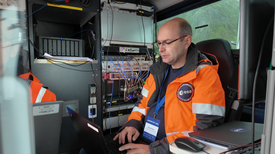
In its pursuit of strengthening European resilience in navigation, the European Space Agency (ESA) took part in Jammertest. Jammertest 2025 brought together 360 participants from 120 organisations across more than 20 countries, spanning academia, industry and governmental institutions.
Incidents of deliberate GNSS interference are on the rise, wih attacks happening daily worldwide. Disruptions threaten safe operations of energy grids, banking infrastructure, emergency transportation and civil aviation, with an outage potentially costing billions of euros daily for Europe.
Bleik on the island of Andøya offered a suitable setting for Jammerfest. (Image: ESA)
Jammertest. In a complex coordination exercise among seven Norwegian public authorities and facilitator Testnor, Jammertest organisers broadcast real satellite navigation interference for participants to observe how their equipment (on vehicles, drones, aircrafts, helicopters and vessels responds.
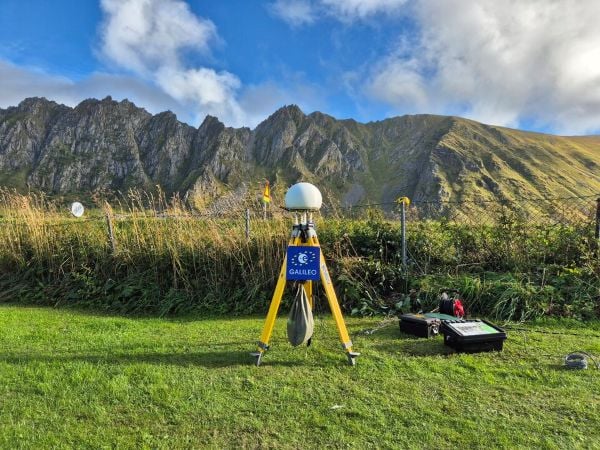
At nearly 70 degrees North and 300 km inside the Arctic Circle, the small village of Bleik on the island of Andøya offers the ideal setting for Jammertest. To the east, towering mountains act as natural barriers that contain disruptive signals, minimising their impact on civil society. To the west, its open coastline allows signals to be transmitted over the sea, supporting maritime participants in addition to air and land users.
The event’s test catalogue is extensive. Organisers simulate everything from simple handheld jamming to complex multi-source attacks launched from several locations simultaneously, including from mountaintops. “The goal is that every receiver is knocked out at some point during the campaign,” explains Tomas Levin, senior principal engineer at Norwegian Public Roads Administration and head of Jammertest.
“At Jammertest, the full GNSS chain sits along a table, from chip manufacturers to those developing the algorithms that run on them, to the companies building products around those chips and the ones integrating these products into larger systems,” Levin said.
ESA’s navigation and telecommunications testbed vehicles are custom-built mobile test platforms operated by ESA’s Navigation Laboratory to support test campaigns for navigation and telecommunications services, most notably Europe’s Galileo constellation. (Photo: ESA)
ESA engineers arrived with several missions. As in previous years, the team tested the robustness of EGNOS and Galileo signals when picked by a range of antennas, from simple mass-market ones found in smartphones to military-grade antennas, both stationary and mounted on a moving van.
A key objective was to test the performance of novel receiver technologies developed under various ESA programs, comparing them to current technologies. The team also tested equipment provided by industrial partners under ESA’s Third-Party services.
More than 100 TB of data were recorded and will support internal research. Moreover, these data can now be replayed at the ESA Navigation Laboratory, allowing industry to analyse how new equipment responds to real-world interference scenarios. (If you are interested in using ESA’s NavLab testing and consultancy services, fill out the contact form on the Consultancy and Testing page).
Finally, ESA also oversaw tests of new EGNOS ground receivers being developed by European industry under Horizon2020 and Horizon Europe programmes. These receivers aim to improve the system’s robustness in its next generation.
A multi-beam satellite navigation antenna test. (Photo: ESA)
Several projects tested at Jammertest by other participants were funded through NAVISP, highlighting the agency’s role in fostering innovation across the GNSS ecosystem.
“Jammertest is a unique opportunity,” concludes Derambure. “Here we have the edge of technology, the edge of testing scenarios. There is nowhere else where we can test this material in real conditions. I believe Jammertest will become a mandatory step for any new satellite navigation receiver technology.”
An A330 airplane carrying Spanish Defence Minister Margarita Robles experienced GPS interference while flying over Kalingrad, Russia, reports EU Today. The news outlet cites Spanish newspaper El Mundo as its source.
Robles was flying to in an aircraft belonging to the Spanish Air and Space Force. It was is “subjected to an attempt to throw it off course using GPS” over Kaliningrad as Robles was travelling to the Šiauliai air base in Lithuania on Sept. 24.
The pilot said incidents attempting to disorient pilots have been common for both commercial and military flights over Kaliningrad. Becausee this was a military craft, the plane was receiving instructions from a military satellite and the attempt failed.
Achieving PNT resilience for critical infrastructure applications
GNSS are magic. They are. One dictionary defines magic as “a power that allows people (such as witches and wizards) to do impossible things by saying special words or performing special actions.” By this definition, we have all become witches and wizards, doing what previous generations would have deemed impossible.
This magic, however, can be affected by external forces that render it useless at best and, at worst, dangerous. Warnings about GNSS positioning, navigation and timing (PNT) service vulnerabilities have been raised for 25+ years. Numerous organizations have warned of the potential safety, security and economic impacts of GNSS interference. Still, like modern-day Cassandras, their warnings have been ignored, and sole use of PNT services that rely on space-based signals continues to expand.
“Magic services” are addictive and cannot be ignored. Yet, it is well past the time to merely admire the problem of GNSS interference — benefitting from magical GNSS services while ignoring existing and emerging threats and challenges. It is time to draw a line and implement resilient, complementary PNT solutions to support all critical infrastructure sectors and applications in the event of any GNSS disruption, due to jamming or spoofing or systemic causes. “Magic” is magical when it works. When it does not, first and foremost, it should “do no harm.”
Threats, Challenges and Needs
Presidential Policy Directive (PPD) 21, Critical Infrastructure Security and Resilience,issued in 2013, defines resilience as “the ability to prepare for and adapt to changing conditions and withstand and recover rapidly from disruptions.” It also notes that “resilience includes the ability to withstand and recover from deliberate attacks, accidents, or naturally occurring threats or incidents.”
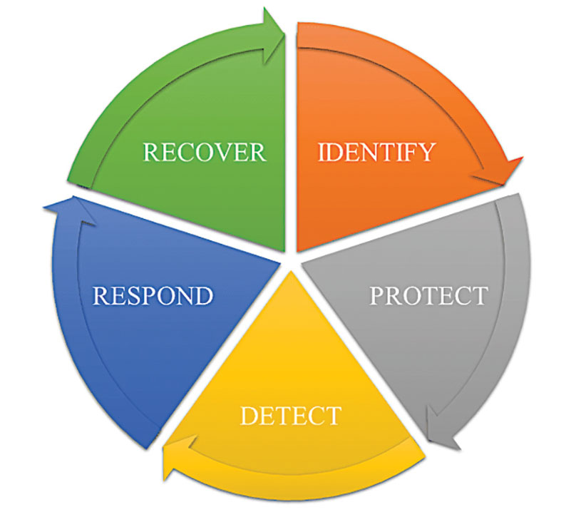
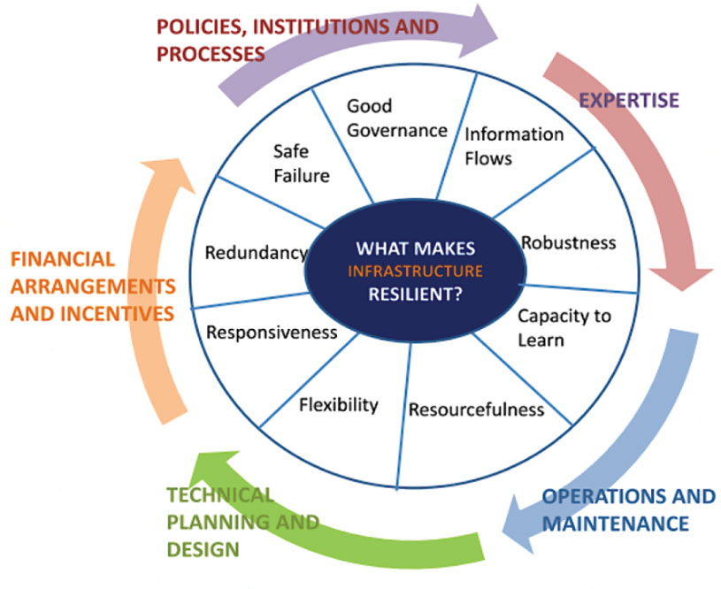
In 2016, the UK Department of International Development noted that “Resilience covers both ‘physical and societal systems” through four “R” principles: robustness, redundancy, resourcefulness and rapidity (see Figure 1).
Figure 1. Infrastructure resilience properties. (Image: UK Department of International Development)
More recently, Andy Proctor (RethinkPNT) pointed out that “A resilient PNT system protects its critical capabilities (assets) from harm by using protective resilience techniques to passively resist or actively detect threats, respond to them, and recover from the harm they cause.”
Policies, processes, financial arrangements and incentives are also crucial to achieving resilience — and that has been, and remains, the problem. Lacking the emergence of strong leadership from our institutions, the ability to achieve actual resilience will continue to falter and admiration of the problem will continue.
Developing a resilient PNT system is always a balance of technical complexity and non-technical aspects, for example, costs. The key consideration for users must be the required performance metrics they need for their use-case(s) to ensure their resilience — including accuracy, availability, integrity, continuity and coverage. The one least understood and many times omitted is integrity — the level of trust a user/use-case needs to safely and securely use the PNT services. The ability to trust PNT services must always be a consideration for critical infrastructure applications.
Unfortunately, many users of critical infrastructure PNT do not know some of the PNT metrics they need to ensure safety and security. More troubling, there is no guidance as to what constitutes “significant economic impact” (see PPD 21) or acceptable economic loss — and over what period or range of use cases. This understanding will require analysis of their design, development and operational experiences, and working with PNT systems engineers to first derive these metrics and then drive the continuous improvements (see Figure 2) needed to achieve and retain truly complementary PNT capabilities. Without clear metrics and guidance, one cannot claim that any solution will meet any “required level of resilience.”
Figure 2. Resilient PNT lifecycle.
Supporting PNT Users
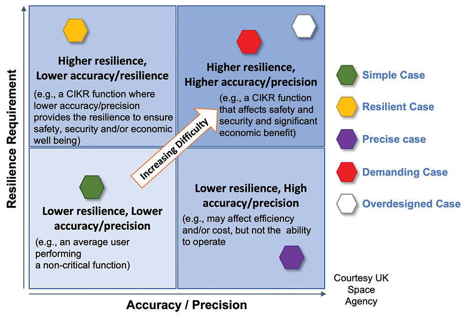
As with all systems engineering (SE) activities, PNT system resilience begins with identifying and documenting user needs based on their specific user stories/use cases. Figure 3 depicts different aspects of resilience that can be sought, depending on the unique use-case “demands.”
Figure 3. Resilience aspects. (Photo: UK Space Agency)
While the resilience needs of different use cases will differ, for any specific use case, a given “PNT solution” will either achieve the required/threshold level of resilience (based on the operational environment) or it will not. Some use cases may also require fail-safe or fail-soft capability and the ability to recover to known, trusted and usable states. Shouldn’t many, if not all critical sector use cases require this?
Equally important is the identification of risks and threats, as they are critical to understanding the challenges that the system must face while continuing to provide the necessary P, N and/or T service performance. It is also key to understand and document the system architecture and environment in which it must perform. With knowledge of a user’s needs, the threats, hazards and challenges they face, and the system architecture, the SE process can develop an understanding of the “gaps” that exist and of the levels of risk they impose on a critical infrastructure system’s functional, physical and operational performance. Understanding this, essential use-appropriate mitigations can be identified, or if need be, developed, and a resilient, solution-agnostic PNT requirement document created.
The Way Forward
The Critical Infrastructure Resilience Institute (CIRI), a U.S. Department of Homeland Security Center of Excellence, notes that “critical infrastructure systems are facing a myriad of challenges. Solutions must address the cyber, physical and human dimensions.” They keyed into four areas where critical infrastructure resilience activities should be directed: building the business case, information policy and regulation, developing new tools and technologies, fostering and educating the workforce.
These include the recognition that “policy and regulation have a powerful impact on market forces.” While the fact that “most U.S. infrastructure is owned and operated by the private sector” is a challenge, it should not be an excuse.
We must start immediately to re-establish strong SE practices, policies, and principles to help critical users understand their needs and determine the metrics required to ensure safety and “preclude significant economic impact.” Only then can we understand from a national perspective, the needed safety and security metrics and what constitutes significant economic impact, and then establish categories of solution-agnostic requirements. Lacking these clear resilience targets, detailed planning, and required resource commitments, the growing threats of PNT vulnerability will continue only to be admired, rather than be mitigated. Hope is not a strategy, but this systems engineer hopes that it does not take a truly catastrophic event to finally prompt much needed and long overdue actions.
Mitch Narins is the principal consultant/owner of Strategic Synergies LLC, a consultancy he formed following more than 40 years of U.S. government service. He is a Fellow of the Royal Institute of Navigation, a aenior member of the Institute of Electrical and Electronic Engineers, a member of the Institute of Navigation and head of its Washington, D.C., section, and a member of RTCA, RTCM, IEEE and SAE Standards Committees.
GNSS researchers are presenting hundreds of papers at the 2022 Institute of Navigation (ION) GNSS+ conference, taking place Sept. 19–23 in Denver, Colorado, and virtually. The following five papers focus on GNSS receiver technology and interference mitigation. The papers will be available at www.ion.org/publications/browse.cfm.
The growing dependence of critical and safety-of-life systems on GNSS makes the ability to rapidly detect and localize the presence of GNSS interference events increasingly important. Ground-based GNSS jammer detection can be used to detect local interference sources. However, this approach is limited by line of sight, hence applying it to large areas is costly in both time and money.
A complementary technique is to use the airborne GNSS receiver data provided by Automatic Dependent Surveillance—Broadcast (ADS-B). As these receivers are at altitude, their lines of sight can cover a wide area. The drawback is that ADS-B was not designed for this purpose, and the messages contain limited information for the assessment of interference.
The authors have developed and will demonstrate an algorithm for real-time detection and localization of GNSS interference sources using ADS-B transmissions on the 1090 MHz (Mode S ES) radio frequency channel. They demonstrate this capability using recorded ADS-B transmissions from known interference events.
Zixi Liu, Sherman Lo, Todd Walter, Juan Blanch, Stanford University; “Real-time Detection and Localization of GNSS Interference Source.”
Even interference at low levels can be catastrophic to systems that depend on GNSS. It can prevent GNSS signals from reaching the user (interference or jamming) or give false signals, resulting in an incorrect position and time solution (spoofing). The capability to confidently detect and localize interference quickly could help mitigate this threat. Furthermore, if the system could also provide information characterizing the interference, it could help law enforcement not only interdict, but also prosecute the threat.
Building a consumer-level commercial-off-the-shelf (COTS) GNSS monitor would also make it cost effective for widespread utilization. This paper describes the development and field testing of a system to provide this capability.
The monitor uses the u-blox F9, an inexpensive commercial receiver offering multi-constellation and dual-frequency position and time solutions, as well as powerful interference-detection metrics. Initial analysis of the receiver’s measurement capabilities determined that it provides many features useful for assessing the operational environment across a geographical region. Performance and output of the receiver is characterized under different jamming and spoofing scenarios.
Different receivers and antennas may react differently based on both hardware and software configurations and offer the user varying interference rejection techniques and detection metrics. As a result, it is important to gain a good understanding of the receiver’s behavior. Another way to test behavior is to examine its performance in nominal conditions in various scenarios and locations, as presented in this paper.
Benon Gattis, Dennis Akos, University of Colorado Boulder; Yu-Hsuan Chen, Sherman Lo, Todd Walter, Stanford University; “Test and Measurements from a Global Navigation Satellite System (GNSS) Monitoring System.”
GEOLOCATING INTERFERENCE WITH SMARTPHONES
Conference Presentation: Virtual; Session F6
With the availability of RAW GNSS measurements on Android smartphones, detecting GNSS interference using modern handsets has become a realistic crowdsourcing possibility, especially with the inclusion of automatic gain control (AGC) in Android 8 (Oreo).
While crowdsourcing jamming detection — and knowing whether your smartphone is subject to jamming or spoofing — is valuable, locating the interference source may be even more important. This work explores the feasibility of crowdsourcing interference source localization with modern Android smartphones.
The work has three goals:
To examine localization of a civilian-type GPS L1 jammer using a network of smartphones
To investigate how best to approach current obstacles regarding such localization
To estimate how accurate this type of positioning can be.
An important part of this work is to investigate differences in GNSS data reported by various Android smartphones. The smartphones in this study were specifically selected by the manufacturer of the GNSS chipset to enable the authors to examine how their GNSS receivers perform under the same circumstances. Three parameters were specifically investigated as measures of received jamming power: carrier-to-noise ratio (C/N0), AGC and the number of tracked satellites.
The selected smartphones were put through a series of tests to examine how these three parameters vary with changing conditions. These tests include subjecting the smartphones to an actual jammer in a controlled lab setup and an investigation of the impact of smartphone (GNSS antenna) position and orientation on C/N0 and AGC. Using the data collected in these tests, several interference geolocation strategies will be discussed.
The authors also consider whether interference localization from consumer-off-the-shelf (COTS) smartphones is currently accurate enough for this use. The shortcomings of smartphone GNSS hardware may be resolved using more clever positioning strategies such as using a larger number of handsets. Alternatively, it may require upgraded hardware and standardization.
Søren Skaarup Larsen, Daniel Haugård Olesen, Anna B. O. Jensen, Lars Stenseng, Technical University of Denmark, DTU Space; “Assessment of RFI Geolocation Using Modern Android Smartphones.”
Multipath mitigation with machine learning relies on offline training with an exhaustive number of labeled observations. Current super-resolution correlation methods, which include MUltiple SIgnal Classification (MUSIC), operate online by testing and choosing from a high number of candidate signal hypotheses.
A new method of MUSIC is presented that reduces numerical complexity and is applied to processing L5 correlation vectors to reduce multipath by identifying the earliest path. The rank of this estimator is examined in static and dynamic conditions in various signal environments. Higher rank allows more signal paths to be identified.
This method is also complementary with various L5 signal-tracking methods such as open- and closed-loop tracking.
Paul McBurney, Norman Krasner, Florean Curticapean, Miguel Ribot, Mahdi Maaref and Lionel Garin, OneNav; “Application of Super Resolution Correlation to Multipath Mitigation in an L5 Channel.”
One of the simplest ways to increase GNSS anti-jamming and anti-spoofing (AJ/AS) performance is increasing the number of controlled reception pattern antenna (CRPA) array elements. However, this increases the size, cost, complexity and required processing power of the overall system. To counter this constraint, the researchers applied a new development in antenna hardware design to GNSS threat mitigation techniques. This resulted in better CRPA performance without increasing the footprint. The work improves AJ/AS performance without adding additional elements, and serves as proof of concept of the application of an adaptively spaced virtual array created with multimodal elements to GNSS AJ/AS.
New breakthroughs in antenna-array research extend the case of non-uniform excitation of elements to the elements’ individual positions. By using multimodal antennas as elements, it has been shown that elements’ phase centers, or perceived locations, can be adjusted with purely electronic means. When applied to each element in an antenna array, this realizes a reconfigurable array.
This research extends the concept of a virtual array with adaptive inter-element spacing into GNSS AJ/AJ methods. A new way to integrate a virtual array into a GNSS application is explored and incorporated into current space-time adaptive processing (STAP) algorithms.
Gabriel Wiggins and Scott Martin, Auburn University; “Applications of a Virtual Antenna Array to GNSS Threat Mitigation: First Results.”
The Canadian Positioning, Navigation and Timing Office (PNTO) is warning stakeholders that Ligado has asked the Canadian government for access to spectrum that neighbors that of GNSS services. The request has long been a major issue in the United States because of the risk of radio frequency interference for GNSS users.
Image: da-kuk/E+/Getty Images
Innovation, Science and Economic Development’s (ISED) Spectrum Management and Telecommunications team announced on Aug. 19 a Notice of Application from Ligado Networks. The application seeks authority for providing terrestrial mobile services in the L-band (1526-1536 MHz in the MSS downlink, and 1627.5-1637.5 MHz and 1646.5-1656.5 MHz in the MSS uplink).
In its application, Ligado Canada is requesting that ISED adopt similar operational requirements and technical rules as those of the U.S. Federal Communications Commission. The rules are spelled out in 2020 FCC order 20-48, “FCC Ligado Amendment to License Modification Applications.” The operational requirements would allow Ligado Canada to provide ancillary terrestrial mobile services over specific portions of its licensed MSS spectrum.
Interested stakeholders can submit comments until Oct. 18 on ISED’s website. Respondents are requested to email their comments in Microsoft Word or Adobe PDF to [email protected].
CANSPACE Listserv is a service of Canadian Space Geodesy Forum and is administered by Dr. Richard Langley.
Galileo Second Generation Batch#1B satellites. (Image: ESA).
Technology multinational GMV has been awarded the NAVGUARD project by the European Commission.
NAVGUARD (Advanced Galileo PRS Resilience for EU Defence) will develop ground and space systems to detect illegal activities on GNSS frequencies and geolocate their sources. It also will build an information-management subsystem together with a user interface to provide a situational awareness picture.
The Galileo Public Regulated Service (PRS) is an encrypted navigation service for governmental authorized users and sensitive applications that require high continuity.
According to the EU Agency for the Space Programme (EUSPA), the PRS signal will ensure better continuity of service to authorized users when access to other navigation services may be degraded (resilience). In cases of malicious interference, PRS increases the likelihood of the continuous availability of the signal-in-space (robustness).
NAVGUARD is among various European Defence Fund (EDF) projects designed to sharpen the competitiveness of the European Union defense industry and strengthen the EU’s strategic autonomy. Besides navigation, the projects contracted to GMV will focus on developing missile defense system capabilities, systems for dismounted soldiers, avionics, command and control and cyber defense.
ITU is the United Nations agency that deals with information and communications technology. Its remit includes coordinating spectrum use and satellite orbits.
ITU’s Radio Communications Bureau sponsors the World Radiocommunication Conference every three to four years. The issue of interference with GNSS signals was reported at the 2019 conference.
Since that time, according to this month’s circular, the group “has been informed of a significant number of cases of harmful interference to the radionavigation-satellite service…”
Despite concerns expressed by maritime and other interests, the circular focuses entirely on aviation interference. It says the reports it has received have been about “receivers onboard aircrafts and causing degradation or total loss of the service for passenger, cargo and humanitarian flights…” These have included “misleading information provided by RNSS [radionavigation satellite service] receivers to pilots.” An often cited example of this is a well-publicized 2019 incident in Sun Valley, Idaho. In that case a passenger aircraft nearly hit a mountain.
Describing interference with GNSS as a global and recurrent problem, the circular cites data collected by a major aircraft manufacturer. The company found “10,843 radio-frequency interference events … globally in 2021. The majority of these events occurred in the Middle East region, but several events were also detected in the European, North American and Asian regions.”
This year’s uptick in GNSS interference in Scandinavia, the Baltics, and around Ukraine since Russia’s February invasion of Ukraine is not mentioned. This is likely due, in part, to timing. ITU’s Radio Regulations Board met in March 2022 and directed the circular be issued.
Many within the positioning, navigation, and timing community have long asserted that interference with GNSS signals, whether deliberate or accidental, constitutes a violation of ITU rules and regulations. This month’s circular affirms this and cites several applicable provisions.
These include prohibitions on harmful interference with any authorized radio frequency transmission, requirements for users to transmit only in bands for which they have authorization, and for all to generally safeguard aviation operations.
The circular highlights provision 15.1 of ITU’s Radio Regulations as particularly applicable. It states:
“All stations are forbidden to carry out unnecessary transmissions, or the transmission of superfluous signals, or the transmission of false or misleading signals, or the transmission of signals without identification…”
As is the case with almost all international agreements, enforcement of ITU rules is the responsibility of its member states.
While most expect the advisory to have little immediate impact on reducing global interference with GNSS signals, it does help reinforce the issue as one of international concern.
According to a retired government official, “Member states that fail to comply with international rules to which they have agreed lose credibility and standing in the community of nations. Even when they have little credibility or standing to begin with, the behavior adds to their marginalization and life is just a little more difficult for them. This can, in the long run, nudge them toward being more responsible players.”
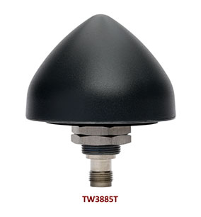
Tallysman Wireless has added the housed TW3885T dual-band (L1/L5) Accutenna technology timing antenna to its line of GNSS products.
The dual-band TW3885T antenna supports
GPS/QZSS L1/L5
Galileo E1/ E5a/b
BeiDou B1/B2/B2a
GLONASS G1/G3
Satellite-based augmentation systems (SBAS) in the region of operation: WAAS (North America), EGNOS (Europe), MSAS (Japan) or GAGAN (India).
Historically, dual-band antennas and receivers commonly supported GPS L1 and L2 and GLONASS G1 and G2. In recent years, GPS, GLONASS, Galileo, BeiDou and NavIC have added GNSS signals in the L5 frequency band (1164-1217 MHz). As a result, the new dual-band GNSS standard has become L1 and L5. Tallysman’s new TW3885T antenna has been tuned to provide optimal support for both the upper (L1/ G1/E1/B1/) and lower (L5/G3/E5/B2) GNSS bands.
The TW3885T is housed in a through-hole mount, weatherproof (IP69K) enclosure. For permanent installations, L-bracket (PN 23-0040-0) or pipe (23-0065-0) mounts are available. Tallysman provides an antenna installation guide that recommends a 100-125 mm ground plane and provides antenna installation and cable connector waterproofing best practices.
The radio frequency spectrum has become congested worldwide as many new LTE bands have been activated, and their signals or harmonic frequencies can affect GNSS antennas and receivers. In North America, the planned Ligado service, which will broadcast in the frequency range of 1526 to 1536 MHz, can affect GNSS signals. New LTE signals in Europe (band 32, 1452–1496 MHz) and Japan (bands 11 and 21, 1476–1511 MHz) have also affected GNSS signals. Tallyman’s new TW3885T mitigates the effects of these new signals.
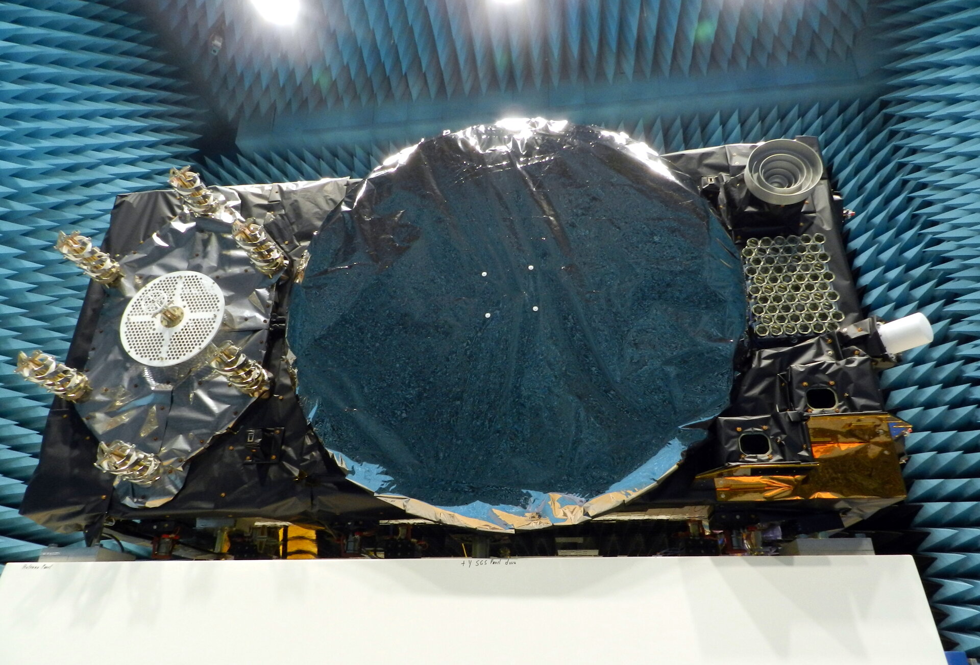
Within ESA’s Maxwell EMC Facility, each Galileo satellite is switched on as if it were already operating in space. The test procedure is a check of the satellite’s electromagnetic compatibility; all its systems are run together to detect any harmful interference between them.
Once Maxwell’s main door is sealed, its metal walls form a Faraday Cage, screening out external electromagnetic signals. The anechoic foam pyramids covering its interior absorb internal signals – as well as sound – to prevent any reflection, mimicking the infinite void of space for satellite testing.
In the photo here, sheathed in multi-layer insulation, the 2.5 x 1.2 x 1.1-meter satellite’s main 1.4-m diameter antenna transmits L-band navigation signals. To its left is the hexagonal search and rescue antenna that will pick up distress signals and relay them to local emergency services, contributing to saving more than 2,000 lives annually.
The Face of Galileo: A Galileo satellite is tested in the Maxwell EMC Facility before heading for space. (Photo: ESA)
To the bottom right of the navigation antenna are a pair of infrared Earth sensors to keep the navigation permanently locked onto Earth by homing in on the contrast between the heat of Earth’s atmosphere and the cold of deep space.
Above them is the laser retro-reflector: lasers are shone up to this from International Laser Ranging Service stations to perform an independent check of the satellite’s orbital position down to an accuracy of less than a centimeter, as a backup of standard radio ranging.
Above that is the circular C-band antenna, which every 45 minutes or so receives the navigation messages from the Galileo ground segment. These signals incorporate corrections for slight clock errors, orbital drift or satellite malfunctions that user receivers can process as they perform positioning fixes, helping ensure Galileo delivers meter-scale positioning to users around the globe.
What resembles a white baton on the end of the satellite is its S-band antenna, employed to return “housekeeping” telemetry data to mission control on Earth and pick up telecommands to operate the satellite platform and payload – as well as performing the ranging used to estimate the satellite’s position in space.
The Maxwell EMC Facility is part of the ESTEC Test Centre in ESA’s technical heart in Noordwijk, the Netherlands – Europe’s largest satellite testing facility, which has flight-tested all but two of the 28 Galileo satellites already in orbit, and is doing the same for the next 10 satellites planned to join the constellation.
The launch of Xona’s test satellite begins a new era of innovation in assured PNT, with NovAtel receivers demonstrating early support of Xona’s signals
Hexagon | NovAtel has signed a memorandum of understanding with Xona Space Systems to collaborate in the positioning, navigation and timing (PNT) development of Xona’s new low-Earth orbit (LEO) constellation.
LEO constellations offer a new avenue of assuring PNT by providing stronger signals with satellites closer to Earth and improved positioning accuracy with rapidly changing geometry, NovAtel explained. Additional constellations and a larger number of available satellites improve visibility in cases where parts of the sky are obstructed by buildings and other obstacles.
Also, as the threat of unintentional or malicious jamming and spoofing increases, it becomes important to consider alternative sources of PNT and resiliency methods, the companies said.
“Precise and robust PNT forms the foundation for safe operation of modern applications such as automotive and autonomy,” said Brian Manning, CEO of Xona. “We are thrilled to be collaborating with NovAtel to demonstrate the benefits that our combined technologies can bring to these markets and many more.”
Xona’s new constellation will transmit encrypted signals on two frequencies, both offering authentication, further building new levels of resilience against malicious interference. NovAtel is an early adopter of Xona’s signals and an industry leader in resilient assured PNT.
“This agreement accelerates the future of alternative PNT,” said Sandy Kennedy, vice president of innovation at Hexagon’s Autonomy & Positioning division. “Our collaboration will demonstrate the complete assured PNT ecosystem that Xona has envisioned, and of which NovAtel is very excited to be part.”
Xona and NovAtel will be presenting innovations in assured PNT and the future of GNSS at the Autonomy & Positioning Reality Summit during HxGN LIVE Global in Las Vegas, June 20-23.