Tag: GNSS interference

  • Resilient PNT is critical, industry experts say

    Resilient PNT is critical, industry experts say

    As PNT becomes critical to more economic activities, any disruption in availability, reliability, resilience and integrity would weaken the critical infrastructure that sustains national security, business operations and public safety, according to experts speaking at the Geospatial World Forum.

    This growing dependency on PNT services — and the potentially high economic cost of vulnerabilities — underscores how vital GPS and GNSS systems are to the global economy and national security of countries worldwide, the experts said. Resilient PNT systems are necessary to combat GPS/GNSS outages.

    Robert Cardillo (Photo: GWF)
    Robert Cardillo (Photo: GWF)

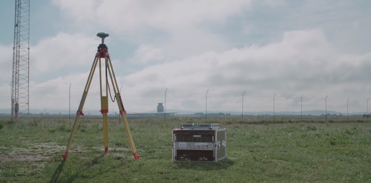
    Building resilience into these systems will require multiple technologies ranging from network time-transfer services to terrestrial wireless infrastructure and low-Earth-orbit (LEO) satellites.

    The Geospatial World Forum opened in Amsterdam on May 10. The second plenary of the day focused on the value of PNT in the global economy. Geospatial World is a global think tank working towards raising awareness around the use of geospatial data and technologies among governments and policymakers, businesses, and the public at large.

    Robert Cardillo, president of The Cardillo Group and former director of the U.S. National Geospatial Intelligence Agency (NGA), headed the panel of experts.

    “Our existence on this planet has been shaped by our individual and collective awareness of place and our confidence to be able to move securely and efficiently from one place to another, all within that common framework of position, navigation and timing, or PNT,” he said.

    “The smartphone is a wonderful example of how far PNT has been integrated into our lives,” said Trimble founder Charlie Trimble. He laid down three basic phases involved in leading PNT to its place in the world economy.

    “The path from the dawn of space age to the smartphone was anything but obvious or straightforward,” Trimble said. “First, Sputnik led to the global navigation systems. Second, the Shuttle disaster led us to the realization that the satellite system was an information utility. And now, the integration of PNT into the mobile and immobile internet is changing our world.”

    From left: Charlie Trimble, Martin Sweeting, Rodrigo da Costa and Gillian Smith. (Photo: GWF)
    From left: Charlie Trimble, Martin Sweeting, Rodrigo da Costa and Gillian Smith. (Photo: GWF)

    “Our first contract was with ESA (European Space Agency) to look at the feasibility of using a navigation and timing satellite using small-satellite techniques, which in 1985 was considered a wacky idea,” recounted Martin Sweeting, executive chairman of Surrey Satellite Technology Ltd. “At ESA, we have embarked on a project called Hydro GNSS, which uses Surrey’s GNSS reflectometry to address several climate related issues, be it water detection or biomass, etc. This doesn’t stop here; we are looking at the lunar economy. PNT has indeed a very bright future, not just on Earth but also looking through this decade into the use of PNT on the lunar surface.”

    Rodrigo da Costa, executive director of the European GNSS Agency. (Photo: GSA)
    Rodrigo da Costa

    “New things are happening, particularly in the area of governmental satellite communications, space situational awareness and others, which are benefitting citizens every day,” said Rodrigo da Costa, executive director, EU Agency for the Space Programme (EUSPA). “Galileo, EGNOS (European Geostationary Navigation Overlay Service), Copernicus and GOVSATCOM programs are key areas of EU space activities. All these programs are massive investments and in the end, the result comes from their utilization in the different areas of our economy and daily life.”

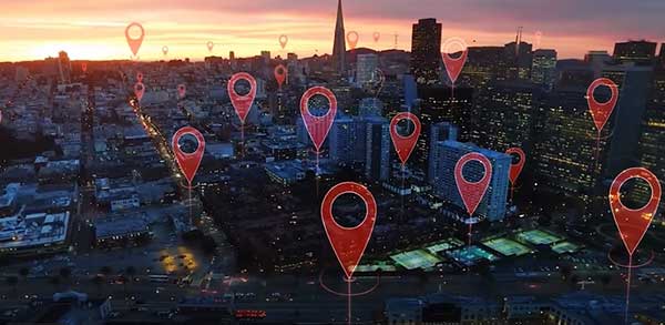
    “Just in the United States alone, GPS is approaching USD 1 trillion in terms of economic impact and is doubling every 2-3 years. But it is a single point of failure. This highlights the need for resilient PNT,” said Gillian Smith, vice president of marketing, NextNav. “We believe that our needs have evolved beyond technology that was really created in the ’60s. We need increased accuracy and availability in the urban environments in particular.

    “I think many of you have experienced it if you’ve tried to use it in any major city,” Smith said. “That blue dot is going to bounce off of buildings and not be very accurate. We need indoor tracking and mapping. We need altitude data so that you know what floor you’re on when you’re thinking about accurate location. We also need to increase resilience and redundancy. That’s going to give us all increased security as well.”

    The Value of GPS

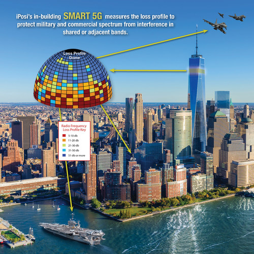
    GPS jamming and interference is a grave issue that has come under the spotlight particularly since the Russian invasion of Ukraine, according to Geospatial World.

    In 2019, a Washington, D.C., think tank documented more than 10,000 cases of GPS interference (jamming and spoofing) in the previous five years from Russia. By 2021, these had become increasingly sophisticated. In a peculiar case, the crew onboard NATO ships in Odessa saw their position being given as Crimea.

    In the past six months, even before the war on Ukraine began, there were reports of GPS jamming in and around that region. In March, the EU Aviation Safety Agency had issued warnings of GNSS spoofing and jamming for flights over Europe, in particular around countries neighboring Ukraine and Russia.

    Globally, the economic impact of GPS/GNSS disruption is difficult to state. The potential economic consequences of failing to sufficiently protect sources of PNT are enormous, with estimates ranging from millions to billions of dollars depending on the type, length, severity and geographic scope of the disruption.

    Furthermore, the impact of a GPS/GNSS outage extends beyond basic economics and could result in risk to life. Emergency services, distress beacons and telecommunications networks all rely on PNT services — any disruption could cause serious consequences.

    A 2019 report sponsored by the National Institute of Standards and Technology estimated that the loss of GPS would cost the U.S. economy USD 1 billion a day.

    A 2017 study in the United Kingdom estimated a five-day GNSS disruption would lead to an economic impact of GBP 5.2 billion (USD 7.2 billion), with road, maritime and emergency service impacts accounting for 88 percent of the cost.

  • DOD authorizes GPS signal processing for 5G shared spectrum

    DOD authorizes GPS signal processing for 5G shared spectrum

    iPosi’s in-building SMART 5G measures the loss profile to protect military and commercial spectrum from interference in shared or adjacent bands. (Image: iPosi)
    iPosi’s in-building SMART 5G measures the loss profile to protect military and commercial spectrum from interference in shared or adjacent bands. (Image: iPosi)

    The Defense Spectrum Office (DSO) of the U.S. Department of Defense (DOD) has contracted iPosi Inc. and Virginia Tech Applied Research Corporation (VT-ARC) to develop a GPS/GNSS system to measure radio frequency path loss that substantially increases shared spectrum without interference.

    The contract addresses the need for increased shared spectrum between DOD and wireless providers who require expanded access because of skyrocketing demand for broadband 5G spectrum.

    The iPosi loss-profile technology automates measurements of GPS/GNSS controlled satellite signal transmissions. Once compiled, these form precise intelligent arrays ultimately characterized as an intensity-based 3D loss-contour map.

    As satellites move across the sky, their signals illuminate radio path obstructions precisely. The 3D map is specific to each site sharing the channel. Each loss-map determines the extent of shared channel radio isolation with a low-error loss between wireless entities, and continuously updates to maintain interference-free channels.

    Though applied initially to sharing DOD ground-to-air systems with commercial wireless services, the technology has wide applications for other 5G services, iPosi said.

    “This relationship is an important foundation for DoD and commercial applications of our technology across a wide range of spectrum sharing initiatives,” said Richard Lee, CEO of iPosi. “We look forward to collaborating with our partners to enable greater spectrum sharing.”

    The agreement represents a collaboration among multiple academic and industry partners, one of several endeavors by the Defense Information Systems Agency and Defense Spectrum Organization under the Spectrum Sharing Test & Evaluation (SSTD) project as part of the DOD Advanced Wireless Systems–3 (AWS-3) spectrum transition program.

    The iPosi/VT-ARC technology would enable a substantial increase in protected, interference-free wireless service that operates in DoD or federal government bands. Once scaled, it could also support broader civilian and federal shared spectrum operations essential to both spectrum protection and growth of 5G.

    Lee cites iPosi’s three-year relationship with VT-ARC and DISA/DSO as an important foundation for commercial and government applications of iPosi’s GPS-based loss-profiling technology. The earlier collaboration led to field validation of new tomographic wireless propagation measurements that enable sharing between new 5G and DOD in common 1-10 GHz mid-band spectrum blocks.

  • DOD tasks Orbital Insight to help identify intentional GNSS disruptions

    DOD tasks Orbital Insight to help identify intentional GNSS disruptions

    A new platform will detect and characterize GNSS spoofing operations using artificial intelligence and commercially available data

    Geospatial intelligence company Orbital Insight has been awarded a contract from the U.S. Department of Defense (DoD) to deliver a technology platform for identifying intentional GNSS interference and manipulation operations across the world.

    The platform will leverage commercially available data to detect GNSS spoofing, where falsified or manipulated GNSS signals are used to confuse adversaries or obscure illicit activities, presenting risk to both government and commercial operations. Orbital Insight was selected through DoD’s Defense Innovation Unit (DIU) solicitation process seeking commercial solutions to counter the growing threat of GNSS disruptions to national security.


    Research suggests that Russia conducted nearly 10,000 spoofing operations from 2016 to 2018 alone.


    The new technology will significantly improve situational awareness for warfighters, intelligence analysts and safety-of-life applications. Orbital Insight’s platform will leverage its multisensor data stack, artificial intelligence and machine-learning capabilities to alert analysts and operators to potential jamming and spoofing events, techniques commonly used by adversarial actors to cover up activities or sabotage operations.

    The platform leverages a suite of geolocation data — satellites, AIS, ADS-B and internet-of-things devices — along with new advanced algorithms designed to automatically recognize anomalies linked to spoofing, complemented by research intelligence from the nonprofit partner Center for Advanced Defense Studies. Research suggests that Russia conducted nearly 10,000 spoofing operations from 2016 to 2018 alone.

    “Helping organizations understand what’s happening on and to the Earth is at the heart of what Orbital Insight does, and spoofing is a national security problem that has proven challenging to solve,” said Kevin O’Brien, CEO, Orbital Insight. “GNSS spoofing is essentially a data problem, and Orbital Insight’s AI and deep data stack can help identify spoofing, along with other major humanitarian and environmental challenges. This is a perfect example of private and public sectors uniting through technology.”


    Other areas that may be addressed: identifying drug trafficking, illegal fishing, sea-borne piracy and unintentional commercial aviation disruptions


    The technology has broad implications that extend beyond situational awareness of intentional GNSS interference. Other national security, humanitarian and environmental challenges may be addressed, such as identifying drug trafficking, illegal fishing, sea-borne piracy and unintentional commercial aviation disruptions.

    Federal agencies are increasingly complementing their systems with commercial technology and data sources that are unclassified, universally accessible, and shareable with allies. The National Air and Space Intelligence Center will be the first customer to utilize the technology. Upon successful integration, the goal will be to expand this platform widely across the defense, intelligence and civil communities.

    Orbital Insight received the DoD contract on the heels of announcing a Phase II Small Business Innovation Research contract from the National Geospatial-Intelligence Agency to deliver a computer-vision model that uses synthetic data to detect novel classes of objects.

    The company also recently launched a new class of multiclass object-detection algorithms within its flagship GO platform to help the intelligence community monitor and differentiate activity at thousands of areas of interest. Like all of Orbital Insight’s products, these algorithms are being developed within an ethics framework that shapes the company’s work and values privacy.

    Image: matejmo/iStock/Getty Images Plus/Getty Images
    Image: matejmo/iStock/Getty Images Plus/Getty Images
  • Research firm Intqlabs files patent on magnetic field location tech

    Research firm Intqlabs files patent on magnetic field location tech

    Image: Credit: Petrovich9/iStock/Getty Images Plus/Getty Images
    Image: Credit: Petrovich9/iStock/Getty Images Plus/Getty Images

    Dubai-based Intelligent Quantum Labs (Intqlabs) has announced that its latest proprietary technology of enabling location data solely from the Earth’s geomagnetic strength is now patent pending (UAE patent office application 202111049994).

    Leveraging more than two decades of experience in developing antennas, sensors, radio analysis platforms and computing algorithms, the new technology incorporates advanced processes to calculate power profile data from magnetic readings. The power profile enables calculation of a location under water, in the air or on the ground within a few seconds.

    The technology, dubbed New Global Navigation Satellite System (NGNSS), was developed to serve as an alternative to existing GNSS platforms such as GPS, GLONASS, Galileo, Beidou, QZSS and IRNSS. NGNSS does not depend on satellite constellation and is not susceptible to being jammed, injected, replayed or spoofed.

    NGNSS operates on the core principle that every point on Earth’s surface and in its atmosphere has a uniquely calculable magnetic strength reading, or a geomagnetic force. This force changes based on distance from the poles, elevation, altitude, time of day, direction of sunlight, magnetosphere, earthquakes, inner core rotation, crust, declination, inclination, ionosphere, magnetosphere, and gyrations that occur in continuity such as solar storms, elevation, topography, altitude changes, spherical variations and regional anomalies

    NGNSS removes interference and noise from geomagnetic readings by using a specialized array of aligned multiple input multiple output (MIMO) antennas connected to a complex network of embedded processors, extremely sensitive fluxgate sensors and other sensors. The antenna and embedded setup processes the magnetic strength reading to obtain the power profile, split the various signals in a profile, and then calculate the direction, origin and location of these sources. This enables NGNSS to identify the true strength of the Earth’s geomagnetic field by removing all sources of interference.

    NGNSS is a secure platform unaffected by jamming, replay or injection as it monitors power profiles and simply drops the malicious data. Furthermore, NGNSS is independent of the GNSS constellations, making it a standalone, secure and “always available” platform that can be integrated within any electronic terminal by strategically embedding a chip and antenna.

  • Spire to develop flexible geolocation signal-processing tools for ESA

    Spire to develop flexible geolocation signal-processing tools for ESA

    Spire logoSpire Global has been awarded a contract under the European Space Agency’s (ESA) Navigation Innovation and Support Programme (NAVISP), specifically “Element 2 – Competitiveness in PNT.” The contract is funded by the United Kingdom Space Agency.

    Spire will work with NAVISP to build on the current capabilities of the Spire constellation and develop tools needed for geolocation signal processing, which will be applied toward geolocating GNSS interference sources coming from the Earth’s surface.

    Spire’s low-Earth orbit (LEO) nanosatellite technology will be used to collect suspect interfering RF signals from a range of geographic areas prone to disruptions. Using advanced processing algorithms, the project will develop a suite of geolocation signal collection and processing techniques (including single and multi-satellite) to detect and characterize signals from a variety of interference scenarios.

    NAVISP Element 2 emphasizes maintaining and improving the capability and competitiveness of the position, navigation and timing (PNT) industry and its technologies and services in the global satellite navigation market. In recent years, PNT services have become ubiquitous and relied on by industry and critical national infrastructure such as telecommunications, emergency services, energy, finance, food and transport. The GNSS signals used in these applications are vulnerable to interference, which can disrupt PNT services.

  • NovAtel SMART7 now default receiver on Fendt machines

    NovAtel SMART7 now default receiver on Fendt machines

    The Fendt 1000 Vario tractor. (Photo: Fendt)
    The Fendt 1000 Vario tractor. (Photo: Fendt)

    Fendt machines in North America, Europe and the Middle East equipped with Fendt Guide guidance systems powered by Fuse Smart Farming now come with NovAtel’s SMART7 GNSS receiver as the default configuration choice.

    “We have been working with NovAtel for years, and their support and willingness to adapt to meet our needs makes them the key GNSS receiver supplier for our Fendt Guide guidance system,” said Bernhard Schmitz, director, FendtONE Market Readiness and Agronomy EME. “They are easy to work with and have high-quality products that integrate seamlessly into our machines.”

    The SMART7 combines a powerful GNSS receiver with a precision antenna in a durable, all-in-one enclosure designed to stand up to the vibration, weather and temperature demands of harsh agricultural environments. Delivering exceptional positioning, the SMART7 is optimized to succeed in demanding agriculture and off-road applications.

    Photo: NovAtel
    Photo: NovAtel

    The SMART7 uses multi L-band tracking to access TerraStar Correction Services globally, bringing repeatable centimeter-level accuracy to any application, anywhere in the world. Access to multi-frequency GPS, GLONASS, BeiDou, Galileo and QZSS signals provides better satellite availability in challenging environments.

    Resiliency to radio frequency interference is ingrained in NovAtel’s hardware designs, and the company’s Interference Toolkit firmware suite provides detection and additional protection from any potential intentional or unintentional interference.

    Powered by NovAtel GNSS+INS technology, the SMART7 uses an optional integrated inertial measurement unit (IMU) to provide continuous 3D positioning, velocity and roll/pitch/azimuth for deeper integration with vehicle guidance and steering systems. Additional optional features on the SMART7 include Wi-Fi and Ethernet for remote connectivity and monitoring.

  • Tallysman adds eXtended Filtering to TW3900 accutenna antennas

    Tallysman adds eXtended Filtering to TW3900 accutenna antennas

    The TW3967-XF antenna. (Photo: Tallysman)
    The TW3967-XF antenna. (Photo: Tallysman)

    Tallysman Wireless has added new eXtended Filtering (XF) features to the TW3900 series of Accuntena precision antennas. Tallysman designed the XF feature to mitigate interference from all near-band signals and ensure that the antenna provides the purest GNSS signals.

    Tallysman’s TW3972XF, TW3972EXF, TW3972LGXF, TW3967XF, and TW3967LGXF are triple-band antennas that support GPS/QZSS (L1/L2/L5), GLONASS (G1/G2/G3), Galileo (E1/E5ab), BeiDou (B1/B2/B2a), NavIC L5, and L-Band correction services.

    Worldwide, the radio frequency spectrum has become congested as many new LTE bands have been activated, and their signals or harmonic frequencies can affect GNSS antennas and receivers. In North America, the planned Ligado service, which will broadcast in the frequency range of 1526 to 1536 MHz, can affect GNSS antennas that receive space-based L-band correction service signals (1539–1559 MHz).

    The TW3972-XF antenna. (Photo: Tallysman)
    The TW3972-XF antenna. (Photo: Tallysman)

    New LTE signals in Europe [Band 32 (1452–1496 MHz)] and Japan [Bands 11 and 21 (1476–1511 MHz)] have also affected GNSS signals. Lastly, the Inmarsat satellite communication uplink (1626.5–1660.5 MHz) commonly used on maritime vessels can also affect nearby GNSS antennas.

    Tallysman’s custom XF filtering has been tested to mitigate new (Europe and Japan) and existing LTE signals, enabling the XF antennas to produce clean and pure GNSS radio frequency data. The deep XF filter technology will be applied to all of Tallysman’s product lines.

  • ION webinar explores GNSS interference mitigation

    ION webinar explores GNSS interference mitigation

    Logo: IONThe Institute of Navigation (ION) is hosting a webinar April 20 on “GNSS interference mitigation: A measurement and position domain assessment.”

    The webinar takes place at 11 a.m. EDT and is presented by Daniele Borio and Ciro Gioia, authors of a paper on the topic.

    Summary

    Modern GNSS receivers have to withstand significant levels of interference in order to operate under harsh conditions, such as in the presence of jamming and of other Radio Frequency (RF) threats. A possibility is to implement pre-correlation interference mitigation techniques that operate directly on the samples provided by the receiver front-end. The speakers’ paper provides an assessment of five interference mitigation techniques at the measurement and position level.

    The analysis focuses on the adaptive notch filter (ANF) and on four robust interference mitigation (RIM) techniques. Several data collections were performed in the presence of jamming, and the data were used for the analysis that shows that RIM techniques do not introduce biases at both the measurement and position level. While the ANF delays pseudorange measurements, the biases introduced are predominantly common to all the observations with a negligible impact on a single point positioning (SPP) solution.

    Learn more and register at the ION website.

  • Quantum Reversal adds new GNSS anti-jam units to product offerings

    Quantum Reversal adds new GNSS anti-jam units to product offerings

    The QR100 and QR201 anti-jamming devices. (Photo: Quantum Reversal)
    The QR100 and QR201 anti-jamming devices. (Photo: Quantum Reversal)

    Quantum Reversal has added several new models to its flagship anti-jamming line. The company introduced in February the QR100 L1/L2 GPS anti-jamming unit and the QR101 L1/L2 GPS anti-jamming antenna.

    The current solution consists now of five products designed for the commercial market to solve the issue of unintentional RF interference or jamming:

    • QR100 – GPS dual frequency L1/L2 anti-jamming unit
    • QR200 – GPS dual frequency L1/L2 anti-jamming antenna
    • QR101 – GNSS multi frequency bands anti-jamming unit
    • QR201 – GNSS multi frequency bands anti-jamming antenna
    • QR202 – GNSS multi frequency band anti-jamming antenna with additional L-band reception
      (1520-1560 MHz)

    All models provide robust GPS or GNSS navigation solution, blocking intentional jamming and unintentional RF interference for services such as timing or 3D positioning.

    All the products are lightweight (230 grams for QR1xx series and 500 grams for QR2xx series) with low power consumption (1-1.5 Watt typically, depending on the configuration), and can be mounted on any platform (cars, poles, drones, etc.).

    Quantum Reversal operates in the information and wireless technology sector, developing innovative wireless and antenna technologies for various commercial markets. The QR team has experience designing products for applications in space, underwater, robotics and unmanned aerial vehicles (UAVs) for the commercial and user end. Each application requires a specific solution to deal with specific environmental (pressure, temperature, vibration, etc.) and operational conditions.

    The company sells stand alone products as well as OEM products that can be integrated within the customer products.

  • Real-time interference detection by GIDAS makes satnav safer

    Real-time interference detection by GIDAS makes satnav safer

    It is estimated that there are currently the same number of satnav receivers on Earth as there are people. (Image: ESA)
    It is estimated that there are currently the same number of satnav receivers on Earth as there are people. (Image: ESA)

    News from the European Space Agency (ESA)

    A new monitoring system developed through an ESA-backed project works like a bodyguard for satellite navigation in use at strategic or safety-critical sites. Known as GIDAS, the scalable system immediately detects, identifies and pinpoints satnav interference sources in its vicinity.

    It is estimated that there are currently the same number of satnav receivers on Earth as there are people. Positioning, navigation and timing signals from space-based constellations such as Galileo and GPS form an invisible, essential infrastructure, underpinning numerous modern aspects of modern life: communications, power and transportation.

    Satellite navigation helps guide a growing number of aircraft, boats, trains and autonomous vehicles. Meanwhile satnav-based time stamps authentic multi-billion euro financial transactions, and coordinate the synchronised running of power grids. Satellite navigation is always on, available everywhere on Earth, so it is easy to take its availability for granted. But as crucial as these signals from space are, they are also vulnerable to ground-based interference.

    “It’s simply a matter of output power,” said Andreas Lesch of Austria-based OHB Digital Solutions. “A navigation signal on the ground is equivalent to the light from a 60-watt lamp aboard a satellite, some 23,222 km away in space in the case of Galileo. So these faint signals can be jammed by more powerful local radio signals, either accidentally or deliberately, or even misleading fake navigation signals, known as spoofing.”

    “Our new GNSS Interference Detection and Analysis System, GIDAS, is designed to safeguard critical infrastructure against jamming or spoofing, by performing continuous monitoring of key signal bands. By doing so, GIDAS can raise the alarm in real time, identify the type of interference then pinpoint the location of these dangerous portable devices causing the interference so the authorities can take immediate remedial action.”

    GIDAS can provide interference detection and directionality with a single reporting station, although a minimum of three stations are required for pinpointing interference sources, linked to an overall monitoring center. Monitoring centers can also be connected together, making the GIDAS system easily scalable, from safeguarding an individual harbour, airport or system critical site up to an entire city or region.

    GIDAS can provide interference detection and directionality with a single reporting station, although a minimum of three stations are required for pinpointing interference sources, linked to an overall monitoring center. (Photo: ESA)
    GIDAS can provide interference detection and directionality with a single reporting station, although a minimum of three stations are required for pinpointing interference sources, linked to an overall monitoring center. (Photo: ESA)

    “People are only now catching up to the seriousness of this problem,” adds Andreas. “Surveys of the highest-density parts of Europe surveys report around three to four jammers hourly.

    “These small devices are technically illegal but are easily available online for a few hundred euros or less, often marketed as personal privacy devices. Jammers are sold as having a range of only a few metres, but can turn out to have a practical range of dozens of metres or more — leading to unintentionally widespread interference, like the famous jammer-equipped U.S. truck driver who shut down Newark Airport navigation systems whenever he drove past.

    “Spoofing is more serious still, with a strong criminal element, where false satellite navigation signals replace real ones, to mislead receivers about their position, employed in the past to down put drones or divert boats.

    “Working in this field for eight to nine years, we have seen a strong growth in interference, even as GNSS becomes ever more crucial. With our passion for GNSS and signal processing, we decided to something practical to combat this development, delivering rapid detection, classification and localisation of interference to our customers.”

    GIDAS was developed by OHB Digital Solutions and Joanneum University through ESA’s Navigation Innovation and Support Programme (NAVISP), working with European industry and academia to develop innovative navigation technology.

    “The company initiated the project through NAVISP’s second element, focused on strengthening European competitiveness in the navigation arena, proceeding on a co-funded basis,” said engineer Thomas Burger, overseeing GIDAS project for ESA. “The plan was to enable a commercially attractive business to get started, and I’m happy to say we made it.”

    “Considering the budget, the project had a wide scope, including the development of a multi-constellation GNSS receiver with all processing stages, an extended digital front end for jamming and spoofing detection, processing blocks transferred to a parallel processor based on a customised fully programmable gate array.

    “And that was only one ingredient of the overall GIDAS system, also including the actual interference detection machinery, the interference locating subsystem, and all the communication, database, and graphical user interface elements needed to create a distributed, human-usable system — which is able to go on working autonomously, only asking for human involvement when events are detected.”

    Now that its two-year NAVISP project has concluded, GIDAS is now being rolled out to several Europe-based governmental and private sector customers.

  • Maintaining the 1-dB standard

    Maintaining the 1-dB standard

    How do we ensure that GPS is protected from harmful interference?

    By J. David Grossman, guest columnist

    J. David Grossman
    J. David Grossman

    Debates in Washington over harmful interference and the coexistence of divergent services are raging. Nowhere are the differences more apparent than when comparing radio navigation services such as GPS to radio communications systems used in wireless communications networks.

    How do we ensure that a satellite-based radionavigation service like GPS, which by design operates below the ambient noise floor, is protected from harmful interference? The International Telecommunications Union’s (ITU) definition of harmful interference provides a starting point, by defining harmful interference as a level that “endangers the functioning of a radionavigation service.”

    With this foundational definition, the internationally established criterion of a 1-decibel (dB) increase in the noise floor, otherwise known as the 1-dB standard, provides the answer, offering a readily identifiable, objective and predictable metric.

    The 1-dB standard uses a 1-dB increase in the noise floor as the distinction between the onset of interference that can be detected by a GPS receiver and harmful interference. (This can be reliably measured by a 1-dB decrease in the carrier-to-noise ratio, C/N0, reported by the receiver). Thus, the 1-dB standard provides a definitive way to protect GPS receivers from harmful interference. Adherence to this standard helps ensure that systems operating in an adjacent spectrum band do not interfere with GPS.

    Why use the 1-dB standard instead of other metrics? The 1-dB standard is based upon well-understood GNSS engineering considerations and is associated with quantifiable changes in the overall noise to which GNSS receivers are subject, with equally well-understood effects on receiver operation. (The 1-dB standard enables system designers and spectrum regulators to carefully assess interference from various sources and analyze their net effect on GNSS receivers).

    It also has been adopted internationally and has a long and well-established proven history of protecting GPS operations from harmful interference in both international and domestic regulatory proceedings.

    So-called “alternatives” to 1 dB, which may be appropriate in the context of radio communications systems, fail to recognize that the accuracy, integrity and reception (availability) of GPS signals used by a receiver can be degraded by interfering noise in ways not immediately apparent to an end user. This means that the effects of degraded service of GPS signals can still be detrimental well before the user loses position accuracy or experiences complete loss of position.

    Additionally, C/N0 is computed at the entry point of a GPS receiver, such that a 1-dB decrease serves as an early warning of interference potentially becoming harmful. Other metrics, computed further downstream, may be indicative of harmful interference already occurring.

    GPS has become a fundamental part of our lives and is an integral engine of the U.S. economy, creating new jobs, and unlocking innovation. Maintaining the 1-dB standard ensures that the GPS success story and American innovation will continue for decades to come.


    J. David Grossman is executive director of the GPS Innovation Alliance.

  • Airbus reminds pilots what to do when GNSS interference hits

    Airbus reminds pilots what to do when GNSS interference hits

    Airbus is providing safety information to all pilots, not just those of the new BelugaXL. (Photo: Airbus)
    Airbus is providing safety information to all pilots, not just those of the new BelugaXL. (Photo: Airbus)

    Commercial airline pilots should be ready if their GNSS interference or jamming takes place. This safety message, along with steps to take, was provided by Airbus in the January issue of its publication “Safety First.”

    In the publication, Airbus is reminding pilots of the consequences and required action in the cockpit, according to Aviation Week. Loss of the GNSS signal can affect navigation and surveillance functions. While built-in redundancies will maintain position computation, up to a dozen systems and functions can be affected.

    Cover: Airbus
    Cover: Airbus

    “A loss of GNSS inputs does not lead to a map shift or an erroneous position computation by the FMS (Flight Management System). In the case of a loss of GPS signal, the FMS switches from the mixed GPS/IRS position to an IRS-DME/DME position or IRS-VOR/DME or pure IRS, in order of priority,” the experts explain in the publication.

    Other affected systems can include the predictive functions of the terrain awareness and warning system, the runway overrun protection system, and ADS-B Out, in which case pilots should notify air traffic control.

    Once the flight is over, pilots should report the GNSS interference event to air navigation service providers.