We each arrived at our current involvement with the GNSS/PNT industry by a different path. For many, it was through engineering, perhaps initially thinking of focusing on completely different challenges than those posed by extremely weak RF satellite signals, intentional interference, or ionospheric scintillation. For others, it was through surveying, which they might have entered to make a living traipsing through open fields — well, traversing them — while working independently and in nature.
For others still, it was through one of the myriad applications of GNSS — from mapping the geographic distribution of the few remaining Amur leopards to guiding a tractor in the field, from commercial fishing in Alaska to conducting search and rescue missions, to training for military raids. Yet for others, it was through business, perhaps because they were tasked to route delivery trucks more efficiently or to track each vehicle in a rental fleet. Professor Richard Langley started out as an applied physicist and a radio tinkerer, building his first radio at the age of 14. My colleagues at North Coast Media got here via a career in journalism, with the steep subject-matter learning curve following their training in writing and editing.
I got here mostly through my passion for maps, charts and navigation. I first became interested in maps as a child — after twice getting lost. The first time, I was 5 years old and lost track of my mother as she entered a store in Berkeley, California, and I kept walking down the street. The next time, I was 7 and had insisted on walking home alone from school in Milan, Italy. I was determined not to let it happen again. So, when I was 11, I was the only kid I knew who walked around Pisa studying a map and a compass.
Next came the topographic maps I used for hiking. In my 20s, sailing around the Boston Harbor islands and off the coast of Maine, I learned to use nautical charts, sextants, radio direction-finders, sonar, radar, Loran C, and, finally, hand-held GPS receivers. I read my first technical article on GPS in 1985, when I was a graduate student in international security at MIT and Harvard, and the U.S. military was building the system. I studied its technical specifications and dreamt about its many possible future applications.
In 2000, when looking for a career change and a job in journalism, I saw a posting for the position of managing editor of this magazine. I applied and 25 years later I am still in the business.
Throughout, I always have been impressed by the deep expertise of the scientists and engineers who created this fantastic GNSS that billions of people use multiple times a day yet take for granted. Those who discount, belittle or even mock the expertise of people who have spent decades studying complex subjects — from climate change to economics, from foreign policy to epidemiology, from education to urban planning — are profoundly unaware and misguided, when not hypocritical. We need experts.
Saying the government must focus on “delivering an operational resilient positioning, navigation and timing (PNT) system for the United Kingdom as soon as we can,” the British Science Minister, Lord Patrick Vallance, announced several initiatives in his opening remarks to the Royal Institute of Navigation’s UK PNT Leadership Seminar on Nov. 20, 2024.
Among them was a funding increase for the National Physical Laboratory’s National Time Centre (NTC) project from £30 million ($38 million) to £62.7 million ($79 million) and a plan to have NTC and the first of the nation’s new eLoran towers at initial operating capability (IOC) by January of 2027.
Plans for all efforts beyond next year were necessarily “subject to spending review.”
Still, seminar attendees were gratified to hear the minister’s endorsement of the 10-point PNT policy framework published by the previous administration in 2023 and his commitment to operationalizing it with implemented systems.
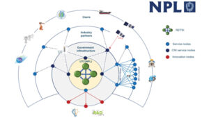
Shabana Haque, Ph.D., head of the United Kingdom’s National PNT Office, also addressed the seminar and elaborated on the government’s actions to date and plans moving forward. She also discussed efforts toward developing quantum technologies and how all the capabilities would be incorporated into a coherent architecture.
Photo: RNT Foundation
Clocks
The United Kingdom recognizes time and timing as the most fundamental component of the PNT utility. Its NTC R&D program, run by the National Physical Laboratory (NPL), has been up and running since 2019. Its primary objective is to create “…a resilient UK national time infrastructure through the building and linking of a new atomic clock network distributed geographically in secure locations.”
Five years later, that program is coming to an end. Plans are in the works for the next phase of the NTC program, which includes developing a national timing infrastructure and supporting a new timing ecosystem — one that includes two-way satellite-time transfer (TWSTT), eLoran and the country’s legacy MSF radio time service. The industry will have a valuable role in the architecture of time distribution and providing value-added services while accessing highly resilient and well-authenticated core government time infrastructure.
As a result of NTC work to date, traceable time and frequency signals can now be accessed by industry and academia from three NPL nodes dispersed across the United Kingdom. They are at the University of Strathclyde in Scotland, the University of Cranfield in the Midlands and the University of Surrey in the south.
eLoran
eLoran also features prominently in the United Kingdom’s PNT plans. Britain operated Loran-C as part of the Northern European network until the end of 2015. For the last year of that, differential stations were deployed along the United Kingdom’s eastern coast and maritime operations based on eLoran were authorized.
On Jan. 1, 2015, and despite British pleas to the contrary, other northern European nations terminated Loran broadcasts in favor of Galileo. The United Kingdom has continued to operate its single eLoran transmitter as a national time signal. Plans call for additional transmitters to enable eLoran navigation across the nation and its adjacent waters within the next two years.
UrsaNav Loran monitor on Nautel equipment. (Photo: RNT Foundation)
The UK government has been working with several partners to advance its understanding and plan for the implementation of an eLoran capability. Haque highlighted work with the European Space Agency’s NAVISP program, resulting in the British company Roke developing an eLoran antenna for handheld devices.
She also discussed integrating the NTC’s clock and fiber network with eLoran signals and developing GNSS/eLoran receivers.
Many were particularly interested in an “eLoran Effectiveness Report” that the government commissioned and received from the General Lighthouse Authority’s Research and Development (GRAD) team. GRAD has extensive experience with the technology, having operated and evaluated the differential eLoran system along Great Britain’s east coast.
In a related move that helped signal the United Kingdom’s commitment to the technology, the Ministry of Defence issued a Request for Information (RFI) in September 2024 about a deployable eLoran capability. The RFI indicated that the document was a prelude to an acquisition.
Quantum research
The United Kingdom has invested more than £1 billion ($1.3 billion) into quantum research, which has the potential to contribute to PNT with better timekeeping and inertial and gravimetric sensing.
One aim of the quantum research program is to develop “…new navigation and timing systems to provide resilience and improved accuracy in the event of the denial of satellite systems.” A specific goal is to deploy quantum navigation systems, including clocks, on aircraft by 2030.
The program began in 2014 and has seen a significant increase in 2024 with the establishment of five quantum hubs nationwide. The hub at the University of Glasgow focuses on resilient PNT systems for national security and critical national infrastructure.
Policy and coordination
Minister Vallance and Haque also discussed two important non-technology themes.
The first was that the United Kingdom’s PNT office is fully funded, staffed, and very active. It was created last year as a cross-government effort and includes representation from the Ministry of Defence. In addition to pushing the nation’s PNT efforts forward, the office has been engaged with numerous other governments, including those of the United States, Canada, Australia, New Zealand, Europe, Japan and Korea.
USCG Loran tower circa 1995. (Photo: RNT Foundation)
Second, while the PNT initiatives are necessary for the nation’s resilience and security they will also be a source of economic benefits. This goes beyond enabling the British economy to function during local and potentially widespread GNSS disruption events. As the nation develops the technology stack to support its own resilient PNT architecture, along with enabling and supporting policies, resilient PNT devices and services will become marketable to others.
A sovereign PNT capability that can both stand on its own and cooperate with GNSS is becoming increasingly attractive to many nations. Being able to source such a capability from a respected and trusted ally such as Great Britain could make acquiring and implementing such a system much easier for many.
The UK Science Minister also praised the RIN’s work and publication of a series of tools to help explain PNT and the need for resilience to those outside the community. The tools also will help organizations evaluate their readiness for GNSS disruptions.
Available from the RIN’s Resilient PNT Portal, they are
A PNT explainer that outlines risks from over-dependence on GNSS and provides links to other informative resources.
A best practices “placemat” describing a “Prepare, Act, Recover” framework for PNT disruptions.
A PNT resilience checklist for organizations to use to self-evaluate their risk from GNSS disruptions.
The RIN recommends PNT experts use these tools working with customers, suppliers, and partners and act as a “guiding hand.”
The RIN sees these all as a “phase 1 release.” Feedback on the tools is encouraged and should be sent to [email protected]. The RIN team is eager to know what works and what could be improved, as well as to receive suggestions for other efforts.
As a “learned society,” the RIN has a significant influence on government policy and direction. This was recognized by Lord Vallance, saying, “The Royal Institute has played a really important role in recent years to highlight the PNT opportunity and risk, to provide expertise, and to work with government on solutions.”
The RIN’s director, John Pottle, and RIN Fellows Ramsey Faragher, Guy Buesnel and Andy Proctor were all recognized during the seminar for their contributions to the organization’s resilient PNT efforts.
UK leading the west
While China is in the final stages of establishing a nationwide clock system integrated with eLoran and signals from space, and South Korea is following suit, the United Kingdom seems to be the only Western nation in the process of establishing a coherent and resilient national PNT systems-of-systems architecture.
Some nations have substantial fiber timing networks, Europe seems to be on the path to a timing backbone, and the United States has three eLoran transmitters on air. However, none have announced the type of integrated plans the UK has published.
When asked about this, one UK PNT technology and policy expert opined that his nation is so far ahead of Europe and the United States because “we are unencumbered by having our own GNSS.”
His idea is that GNSS involves a lot of time, effort and money. The kind of financial and emotional commitments needed for these huge projects makes it hard for many to come to grips with the limitations and vulnerabilities of GNSS and the need to implement complementary systems. Both government officials and GNSS industry lobbyists may tend to resist such efforts, he said.
Concerning the UK government’s investment in OneNav, he said it is still possible that the United Kingdom might also pursue a space-based capability. Rather than establishing the capability on its own, in his opinion, the government will be much more likely to look for a commercial subscription service.
“We will access GNSS when we can trust it, and may pay for other signals from space,” he said. “But we want a sovereign capability for the United Kingdom, and the future of resilient PNT is terrestrial.”
In 2024, we witnessed emerging trends, challenges and opportunities that significantly impacted the GNSS/PNT industry, ranging from advancements in surveying technology to ways to combat the increasing threats of jamming and spoofing. In this year in review, we highlight notable stories from 2024.
This article discussed advancements in bathymetric surveying techniques, highlighting three projects — from SBG Systems, CHC Navigation (CHCNAV) and Advanced Navigation — that are charting underwater environments. It showcased the exploration of the Great Blue Hole in Belize using submarine-mounted sonar, creating a digital twin flood model for China’s Yellow River using unmanned surface vehicles (USVs) and UAVs and the development of an autonomous vessel for surveying wet gaps in military operations.
February
Aligning the trades: GNSS for architecture, engineering and construction
Surveying is an ongoing process on construction sites. Surveyors are the first on the site before any other work begins and the last ones there to map the project “as built.” Total stations with GNSS receivers, tablets and other mobile digital devices are their essential tools, increasingly complemented by UAVs and lidar scanners. In this story on architecture, engineering and construction (AEC), we highlighted three building projects — from ComNav Technology, CHCNAV and Eos Positioning Systems — as well as photos from Juniper Systems.
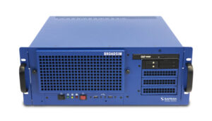
Photo: Safran Federal Systems
March
2024 GPS World simulator buyers guide
In our 13th annual Simulator Buyers Guide, we featured simulator tools, devices and software from nine prominent companies that aid GNSS receiver manufacturers in product design.
April
L5-first for improved resilience in mass market GNSS
Paul McBurney, co-founder and CEO of oneNav, emphasized the advantages of L5-first GNSS receivers in enhancing resilience against GNSS interference and jamming in mass market applications. He shared how traditional receivers prioritize L1 signals, limiting their effectiveness in high-interference environments, while L5 signals, which have a higher chipping rate and power, can improve jamming resistance by up to 15 dB. The article advocated for the development of L5-first systems to boost GNSS resilience, particularly for critical infrastructure, although challenges such as acquisition complexity and cost must be addressed before widespread adoption.
May
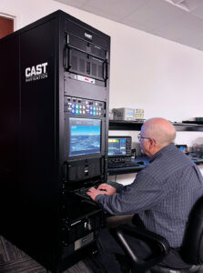
(Photo: CAST Navigation)
Combating jamming and spoofing: PNT on the battlefield
Jamming and spoofing continue to be the key challenges to military use of GNSS. While the production and adoption of M-Code receivers is delayed, defense contractors are developing several approaches to identify, locate and neutralize these threats — including CRPA antennas, embedded GPS inertial (EGI) navigators, software-defined radios and cryptography. In this cover story, executives from seven companies presented their perspectives on the GNSS/PNT challenges faced by U.S. and allied military forces, their market niche in this area and their latest products.
June
NextNav petitions FCC for new spectrum band
NextNav’s petition to the FCC seeks to reconfigure the 902-928 MHz band for a new terrestrial positioning, navigation and timing (TPNT) service. This service aims to complement GPS, enhancing location reliability in urban areas. The integration with 5G technology could further improve positioning services. However, the petition has raised significant concerns within the GNSS industry. Industry leaders argue that granting NextNav access to this spectrum could disrupt existing technologies that rely on the same band. The proposed higher power levels could lead to interference, jeopardizing the operational reliability of various sectors, including supply chains and healthcare. The Federal Communications Commission (FCC) has received more than 1,700 comments highlighting concerns about harmful interference and calling for careful evaluation before any regulatory changes are made. The outcome of this petition could significantly influence the future landscape of positioning technologies in the United States, affecting both GNSS capabilities and the viability of critical applications that depend on current spectrum usage.
July
PNT without GNSS
For the fourth year in a row, the topic for our July cover story was complementary positioning, navigation and timing (PNT). The ongoing challenges of combating jamming and spoofing, as well as enhancing resilience in PNT systems, have been prominent themes in our articles and industry throughout 2024. The U.S. National Space-Based Positioning, Navigation and Timing Advisory Board has been actively working on strategies to “protect, toughen and augment” GPS. The term “augment” refers to enhancements made to GPS and the integration of complementary PNT sources that can partially or fully replace GPS. For this cover story, Editor-in-Chief Matteo Luccio interviewed executives from four companies that design, produce and operate various complementary PNT technologies, highlighting their diverse approaches to this challenge.
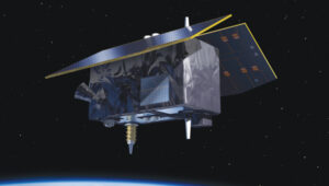
Genesis satellite.
August
Innovation: ESA’s Multi-Modal space mission to improve geodetic applications
The European Space Agency (ESA) has established the Genesis mission, a groundbreaking space project that will collocate four space-based geodetic techniques — GNSS, VLBI, SLR and DORIS — on a single satellite for the first time. This mission aims to improve the accuracy and stability of the International Terrestrial Reference Frame (ITRF) to 1 millimeter with long-term stability of 0.1 mm per year, which is crucial for detecting small variations in Earth’s solid, fluid and gaseous components. The Genesis satellite, set to launch in 2028, will orbit at an altitude of about 6,000 km with an inclination of 95° and will operate for at least two years. Members of the Genesis mission team shared how it has the potential to significantly impact various GNSS and Earth observation applications by improving geodetic and geophysical observations, as well as enhancing precise navigation and positioning capabilities.
(Photo courtesy of ION)
September
ION GNSS+ 2024
ION GNSS+ 2024, held Sept. 16-20 at the Hilton Baltimore Inner Harbor, showcased more than 400 technical presentations spanning six sectors. GPS World had the opportunity to engage in a series of discussions and panels, including a plenary session with a presentation on a space project and one on circumnavigating the globe in a sailboat using only paper charts, a compass and a sextant to navigate.
INTERGEO 2024
The GPS World team touched down in Stuttgart, Germany, for INTERGEO 2024, held from Sept. 24-26. This year’s expo and conference showcased solutions to address critical global issues such as GNSS jamming and spoofing. GPS World Publisher Brian Kanaba and Account Manager Tim Carolin made their debut at the show, joining show veteran Editor-in-Chief Matteo Luccio. The show attracted more than 17,000 visitors from 121 countries and featured 579 exhibitors.
October
Lidar helps unlock secrets in Amelia Earhart mystery
The October edition of “Mapping Marvel” focused on research conducted for The Discovery Channel’s documentary, “Finding Amelia.” This film explores the latest expedition aimed at uncovering the mysterious fate of Amelia Earhart. It featured contributions from SPH Engineering and investigated the theory that Earhart and her navigator, Fred Noonan, may have crashed in Papua New Guinea during their 1937 attempt to circumnavigate the globe.
The team utilized lidar technology to conduct low-altitude flights that produced detailed maps of the ground beneath the dense jungle. This approach revealed potential hidden features, including Japanese troop trails and a structure resembling Earhart’s Lockheed Electra.
November
Richard Langley
The last one: A look back at 35 years of ‘Innovation’
The November 2024 issue of GPS World featured Professor Richard Langley’s 300th and final “Innovation” column. His first one appeared in the January/February 1990 issue, the magazine’s very first. In celebration of Richard’s decades-long contribution to GPS / GNSS / PNT, we published a selection of testimonials and photos from some of his colleagues and friends, gathered by his former students Sunil Bisnath and Attila Komjathy.
December
Directions 2024: GNSS constellation updates
This year’s “Directions” feature offers updates on all four GNSS constellations and a regional one. Representatives from each program — BeiDou, GPS, Galileo, GLONASS and QZSS — reflect on the year’s developments, sharing how PNT technologies aim to enhance both defense and civilian applications, ultimately improving navigation capabilities worldwide. The feature highlights significant milestones, including the modernization efforts within each constellation.
Timing — the unglamorous yet essential T in PNT (positioning, navigation and timing) — has been called “the invisible utility.” In fact, it’s been a long time since we last put a GNSS-timing receiver on the cover. (Partly that’s because, like with simulators, it’s hard to come up with a visually compelling image that conveys the role of such a device.)
From St. Augustine (“What, then, is time? If no one asks me, I know what it is. If I wish to explain it to him who asks, I do not know.”) to theoretical physicist Carlo Rovelli (who argues that time is “part of a complicated geometry woven together with the geometry of space”), time is both one of the greatest mysteries of nature and one of our most practical concerns. For satellite navigation, time is both essential to its functioning and a fabulous by-product. As David Wells and Alfred Kleusberg wrote in the first “Innovation” column, in the first issue of this magazine, “One of the by-products of getting an SPS [Standard Positioning Service] position fix is that a clock in the user’s receiver is automatically synchronized to clocks in the GPS satellites to an accuracy of one ten-millionth of a second. Therefore, any GPS receiver is a very accurate time distribution device.” (“GPS: A Multipurpose System,” January-February 1990.)
As Richard Langley wrote in another early “Innovation” column, “Thanks to minute energy changes in individual atoms of cesium and rubidium, humankind possesses the ability to synchronize clocks anywhere in the world to better than 10 nanoseconds. But given this amazing ability to measure time, we still don’t know what time actually is.” (“Time, Clocks, and GPS,” November-December 1991.)
I procrastinated the task of writing this editorial and now another aspect of time is here to impose its claim: our production deadline. So, just one anecdote and a final quote, and I will be done, just in time.
The anecdote. A quarter century ago, during my first time around on this magazine’s staff, when Glen Gibbons was the group editorial director, Alan Cameron the senior editor, and I the managing editor, we had just one meeting a month, called “edit check,” a couple of days before the deadline to send each issue to the printer. We printed out all the pages, laid them down in order around a large conference room table, and walked around the table examining each one and making notes about small final corrections and revisions.
Only one page routinely had a large empty area: It was the one for Glen’s monthly editorial, which he always finalized (wrote?) at the last possible moment. I once joked that it would be blown in at the printing plant like the magazine’s subscription cards. Well, as I finish this editorial, we are at T minus two days for the November issue. Enjoy it!
Oh, and the final quote, again from Rovelli: “The events of the world do not form an orderly queue like the English. They crowd around chaotically like the Italians.”
Change from one generation of GNSS receivers to the next is generally evolutionary, not revolutionary. As with other technologies, it follows a feedback loop between end-user requirements and technical advances. Additionally, GNSS receivers can now take advantage of four full GNSS constellations, two regional ones, and a plethora of corrections/augmentation services — and increasingly must be able to counter jamming and spoofing.
To get the perspective of GNSS receiver manufacturers on these issues, I asked four questions to the following company representatives:
For longer versions of their responses, as well as responses from additional companies, visit here.
Question: What is currently the best way to take full advantage of the large number of GNSS satellites — four full constellations and two regional ones — and of the many corrections/augmentation services?
Korsakissok: Many satellites in view means greater precision in urban areas, where the view of the sky is partially masked, better resilience to adversity (jamming, spoofing, constellation disruption) and, more generally, greater precision even with a clear view of the sky, thanks to local augmentations. Users working on autonomous vehicles are asking for these advantages, with the goal of achieving a certified and secured system. Technically, to have an optimal usage of this multiplicity of satellites and signals, a receiver should be able to make a fix, even with one or two satellites of each constellation in view, as we do at Syntony. Practically, because of the heritage, it is not so often the case: Many receivers, even today, make a position, velocity and time (PVT) calculation with GPS first and then use the other signals to improve it.
Lopez: To fully leverage all GNSS constellations and regional systems, it is essential to utilize multi-constellation and multi-frequency receivers that significantly enhance accuracy and reliability. These advanced receivers not only improve performance by accessing a broader range of satellite signals but also ensure consistent positioning in challenging environments, such as urban areas with tall buildings or rural regions with obstructed views of the sky.
Septentrio’s antarx is a rugged GNSS/INS multi-frequency smart antenna. (Photo: Septentrio)
Some GNSS manufacturers limit signal usage due to inadequate hardware that cannot track multiple signals and their desire to reduce costs (e.g., CPU power or the number of signal tracking components). Effectively tracking multiple signals and constellations necessitates a robust hardware architecture as well as efficient algorithms that can operate optimally in compact embedded systems to fully leverage all available signals in space. At Septentrio, we prioritize maximizing all available signals to deliver the best possible performance for users while ensuring that our solutions remain valuable and accessible for a variety of applications.
Utilizing multiple GNSS signals not only enhances accuracy, availability, and reliability but also improves resilience and GNSS security, offering crucial protection against jamming and spoofing — issues that are becoming increasingly critical for many applications. Moreover, manufacturers must prioritize compatibility with various correction systems, which provide real-time data to improve positional accuracy further. Ensuring that receivers can seamlessly integrate with multiple correction services allows for smooth adoption across diverse market applications, catering to the unique needs of different industries.
To meet market demand, Septentrio has developed the Agnostic Corrections program, enabling customers to select from a range of well-established and affordable correction services. This approach offers flexibility and access to key service providers in the industry. Since these services support various signals, the advantage of our receivers is key to accommodate the wide array of signals and format messages used by these correction services.
At Septentrio, optimizing these elements is central to our vision and strategy for GNSS core technology. By focusing on performance, reliability, and compatibility, we aim to deliver innovative solutions that meet the evolving demands of the market while maintaining our commitment to excellence in GNSS technology. This strategic approach not only enhances the user experience but also positions Septentrio as a leader in the GNSS field.
Wang: To fully benefit from commercial PPP corrections, receivers must be capable of receiving signals from all GNSS constellations and frequency bands, and support SBAS and L-band services. On the software side, optimizing GNSS satellite utilization involves feeding the navigation filter with a wide range of observations from each available constellation. This, combined with adaptive interference mitigation algorithms and receiver autonomous integrity monitoring (RAIM) techniques, can greatly enhance the robustness and resilience of GNSS solutions in challenging environments such as urban canyons, interference, and spoofing.
Farrokhi: Regional services are categorized as augmentation systems. They are offered through both satellites and terrestrial systems. Satellite-based augmentation systems include but are not limited to SBAS, WAAS, AGNOS, MSAS, GAGAN, NavIC and QZSS. Terrestrial augmentation systems include but are not limited to GBAS, and GLS. Correction services include but are not limited to RTK and PPP.
Supporting these regional and correction services along with multi-band support increases the complexity of the receiver hardware and associated firmware. It is important to note that not every application or use case requires all these different services. For instance, asset tracking utilizing battery-operated tags do not require correction services or L5 acquisition. Low-power operation and simplicity of the GNSS receiver is key to longevity of operation in such applications.
The selection of correction service is highly dependent on the type of communication pipe supported by the hardware. For instance, L-band capability is required for satellite-based correction services, whereas LTE is needed for terrestrial based services.
Ching: I think one of the best ways is to embrace all the available signals on hand. What that means is with the luxury of redundancy, the system can select the best signals to use into the position estimation algorithm. Our OEM7 uses multiple constellations (GPS, GLONASS, Galileo, BeiDou, QZSS and NavIC) and multiple frequency bands (L1, L2, L5 and E6).
Q: Are the requirements for different end user applications — for example, surveying vs. fleet tracking — still very different or are they converging as capabilities increase?
Cerber CRPA Receiver with four-channel antenna and Constellator CRPA simulator. (Photo: Syntony)
Korsakissok: In a way, everybody is benefiting from better precision year after year, using the standard open signals; related to that, we can say that the solution capabilities are converging. A bit. However, we do not see everybody converging toward a “high precision real-time PVT every time everywhere.” Bringing 20-cm precision to a truck-tracking application is nice, but nobody will ever want to pay for this, if it is not relevant for how they use the application. Conversely, for precision agriculture, precision mining and autonomous vehicles, it will always be required, and they will be able to pay for the precision, when associated with reliability, in order to achieve the targeted level of safety.
Lopez: Although GNSS technology has evolved significantly in recent years due to the growing demand for accuracy across new applications, the requirements among different applications remain highly varied. Some may need centimeter-level precision, while others are satisfied with accuracy within 10 centimeters. Survey-grade applications still demand millimeter-level accuracy, while certain autonomous systems may only require 1 to 10 centimeters of precision. Additionally, the environments in which these applications operate vary, such as a surveyor working in unobstructed ground conditions versus a drone navigating through complex airspaces, where jamming, signal availability, and interference can affect performance.
The increasing number of applications that rely on accuracy has resulted in diverse requirements across the board. This is why customers seek more flexible GNSS receivers to balance availability, accuracy, and reliability based on the specific use case. There’s a broad spectrum of needs — not only in GNSS performance (accuracy, time to fix, reliability) but also in security (anti-jamming, anti-spoofing, cybersecurity) and hardware design. For example, some users need compact solutions for small form-factor devices, while others prefer robust systems that can endure harsh environmental conditions. A surveyor, focused on achieving high accuracy, may not need the same GNSS resilience required by critical infrastructure or autonomous systems, where safety mechanisms are crucial.
As more prosumer and innovative applications advance, their needs differ from those of industrial or critical-use cases. At Septentrio, we offer solutions that fill the gaps when lower-end options fall short, attracting customers dissatisfied with third-party products that fail to meet their needs. Septentrio also provides enclosure solutions with stringent environmental protection requirements, including water resistance, humidity control, vibration tolerance, and corrosion resistance.
While GNSS technology continues to advance and become more sophisticated, we also see that the gap between different applications is narrowing. Fleet tracking, for instance, is beginning to benefit from more precise positioning and the ability to use multiple GNSS constellations for autonomy — features traditionally reserved for high-precision applications such as surveying. The cost of high-precision GNSS receivers is also decreasing, making advanced features more accessible across various industries.
However, this increased autonomy introduces new demands, such as top performance and safety in complex environments, and seamless integration with sensor fusion and other ecosystems. Traditional GNSS receivers used for basic fleet tracking will not meet the needs of these advanced use cases, even if they remain part of the same vehicle or platform.
In summary, despite a trend toward the convergence of GNSS capabilities that enhance accuracy, the core requirements of these applications remain distinct, challenging the industry to develop more universally applicable solutions.
Wang: From our point of view, while GNSS performance is steadily improving, manufacturers still need to strike a balance among cost, accuracy, and availability to meet the diverse requirements of different user applications. In surveying, for example, accuracy is the top priority, while in transient control, integrity and availability are more critical. Although GNSS capabilities are increasing and some convergence of requirements is occurring, significant differences remain, necessitating careful design and optimization by manufacturers to address these varying needs.
Farrokhi: The requirements for surveying, for instance, do not apply to the rest of the market. For surveying, extreme accuracy is a must, hence utilizing RTK services and the cost of the solution is usually high. On the other hand, asset tracking, for instance, can benefit from high sensitivity, low power, low cost and cloud processing to reduce power consumption in the asset tracking device.
Generally speaking, the GNSS market falls into the following categories:
Low power, low cost — such as asset tracking
High precision — e.g., surveying and agriculture
High precision, with high reliability — such as ADAS
High speed, high G — in defense applications
Anti-jamming and anti-spoofing — such as in avionics and defense
etherWhere’s next generation hardware solution enables the convergence of all these disparate applications onto one hardware platform by utilizing flexible software and cloud processing.
Ching: Ultimately, regardless of applications, users want the reported positions that are accurate with trustworthy quality indicators. As capabilities increase, I expect more requirements to converge. For example, both surveying and fleet-tracking applications need to operate during ionospheric scintillations. Having a robust positioning solution in both applications is essential. Hexagon | NovAtel released updated firmware (versions 7.09.01 and 7.09.02) in April 2024 to increase ionospheric resilience.
Q: What is the best way to integrate complementary sources of PNT — such as LEO satellites and ground-based systems — into end user hardware and software, to maximize resilience during GNSS disruptions or outages?
Korsakissok: Such integration will be eased for all the new sources that can be acquired with the same RF stages, meaning mostly L-band as of today. SBAS has paved the way and emits at the same carrier frequency as the classic GNSS. U.S. and European low-Earth orbit positioning, navigation and timing (LEO-PNT) projects have included such signals in L-bands, and other telecom constellations can also be used that way (Inmarsat, Iridium, etc.). Because of this, all these L-band extensions to classical GNSS will be the first in line on everybody’s roadmap. When C-band signals will be emitted by GNSS constellations, then telecom ones could also be easily integrated. However, that will take many years.
Lopez: To enhance resilience during GNSS disruptions or outages, integrating a multi-layered approach with complementary sources of positioning, navigation, and timing (PNT), such as LEO satellites and ground-based systems, into end-user hardware and software is crucial. While GNSS technology will remain essential, the combination with other technologies such as inertial sensors and sensor fusion will become increasingly important as these solutions become more available.
Although alternative PNT mechanisms can bolster resilience, the strengths and protections at the core of GNSS are vital for many applications, especially since GNSS manufacturers possess the expertise to address jamming and spoofing effectively. This layered security approach resembles the “onion model” in cybersecurity — adding more security layers enhances protection against disruptions.
While LEO technology is advancing, its full value for PNT may take a few more years to materialize. In the meantime, other sensor technologies, such as inertial navigation systems (INS), already provide significant benefits in the absence of GNSS or in the most difficult conditions to GNSS.
At Septentrio, we are committed to developing products that invest in sensor fusion technologies (GNSS/INS), and we actively participate in key LEO programs that promise substantial improvements in resilience and other PNT aspects, including GNSS corrections and enhanced multipath mitigation for optimal performance in challenging environments. We view this evolution as critical to our product roadmap and consider it a strategic priority for our company.
Wang: The foundation of an effective positioning system is robust hardware that supports the integration of multiple PNT sources. Building on this multi-source signal base, a set of advanced algorithms is necessary to selectively use the signals and filter out interference, enabling the seamless fusion of these sources and achieving superior performance. Moreover, redundant and backup filters are crucial for maintaining the robustness of the positioning solution, particularly during GNSS disruptions or outages.
Farrokhi: etherWhere’s next-generation solution supports LEO constellations such as Xona Space to enhance location tracking and provide resilience and redundancy. LEO satellites signal strength is higher than GNSS satellites due to their lower orbit and as such provide better link margin. The key to ubiquitous adoption is in a well-integrated single chip solution at lower power consumption.
Ching: Complementary sources of PNT must be proven to provide a consistent improvement in positioning performance, beyond what GNSS alone can provide. For example, increasing availability is not helpful if the quality indicators cannot be trusted. The integration must be an overall benefit to the user, in terms of ease of use, positioning performance and reliability. Our team is already leading the market and working with key stakeholders and partners to provide PNT beyond GNSS as we announced in previous years.
Q: What are the key innovations in your latest receiver or generation of receivers?
Korsakissok: Syntony is well-known to have one of the first full SDR embedded receivers, working in multi-frequency and multi-constellation mode. Thanks to that, we were able to be the first to demonstrate the coupling with XONA, at ION GNSS in 2022, and have been chosen by the European Space Agency (ESA) for their own LEO PNT: Flexibility and ease of modification are the major advantage of full SDR, versus ASICS.
Today, our SDR receiver is embedded in cars, trains, UAVs, launchers and satellites, but also in trucks for underground mining, together with our SubWAVE solution. Not to mention our CRPA version, which is capable of state-of-the-art anti-jamming level, completed by exclusive anti-spoofing mitigation, as we can compare, directly inside the receiver, the direction of arrival of all GNSS signals with the ephemeris, avoiding retaining and tracking the ones that are spoofed.
Lopez: This year, Septentrio has achieved notable advancements in GNSS receiver technology by enhancing resilience against jamming and spoofing and by launching the AntaRx product line. It offers high-precision performance, a durable design, and versatility for industrial applications, such as construction and mining. With advanced anti-jamming and anti-spoofing across all products, plus the AntaRx — which is an all-in-one GNSS, antenna, and sensor fusion solution — we remain committed to delivering the most reliable positioning in the most challenging environments.
Lopez: In response to evolving market demands and guided by our strategic vision, Septentrio has made significant advancements in GNSS receiver technology, focusing on two major pillars: resilience and performance.
Resilience: Septentrio has established a reputation for providing robust GNSS solutions thanks to our AIM+ technology, and we remain committed to enhancing resilience across our product line. Our latest innovations have significantly improved our receivers’ ability to detect and mitigate spoofing attacks. These enhancements have been validated through rigorous testing, including recent GNSS jamming tests conducted in Norway (see Norway results here), as well as field applications where our receivers have successfully operated in contested environments, particularly within drone applications. This continued focus on resilience ensures that our customers can rely on our technology even in challenging conditions where signal integrity is paramount.
AntaRx Product Portfolio: This year, we proudly launched the AntaRx product line, specifically designed to meet the rigorous demands of industrial applications such as construction, mining, and robotics. The AntaRx series offers a variety of configurations, including single-frequency, dual-frequency, and inertial variants (GNSS/INS), providing unparalleled flexibility for a wide range of use cases (see more about this product here).
What sets the AntaRx apart is its exceptional high-precision GNSS performance combined with core reliability. This product line is compatible with various correction services, allowing users to achieve optimal accuracy regardless of their operational environment. Moreover, the AntaRx features advanced anti-jamming and anti-spoofing technologies, which are critical for ensuring the integrity of positioning data in areas where interference is prevalent.
In addition to its technological innovations, the AntaRx is designed with ruggedness in mind. It is built to withstand harsh environmental conditions, making it suitable for deployment in demanding industries. The user-friendly interface simplifies operation and enhances the user experience, ensuring that both seasoned professionals and newcomers can easily integrate the technology into their workflows.
Furthermore, the AntaRx incorporates sophisticated sensor fusion capabilities, combining GNSS with inertial data to enhance overall positioning accuracy and reliability. This integration is particularly beneficial in environments where GNSS signals may be obstructed or unreliable. The careful design of the AntaRx, which includes an integrated antenna and GNSS components, significantly improves multipath mitigation, further ensuring optimal performance even in challenging conditions.
In summary, Septentrio’s commitment to innovation is evident in our latest GNSS receiver developments. By focusing on resilience and advanced capabilities, particularly with the launch of the AntaRx product line, we aim to provide our customers with the most reliable and high-performing GNSS solutions tailored to meet the diverse demands of various industries. As technology continues to evolve, we will remain dedicated to enhancing our products to meet the future challenges of positioning, navigation, and timing.
Wang: Our newest product, the RS10, leverages cutting-edge technologies to achieve seamless integration of GNSS with SLAM, vision, and INS. This fusion has resulted in the RS10 delivering enhanced accuracy and reliability while providing an exceptionally efficient solution for the surveying and mapping industries. By combining these complementary technologies, we’ve made a significant leap forward in advancing the performance and capabilities to benefit geospatial professionals.
Farrokhi: At etherWhere, we have innovated on multiple fronts to address different use cases.
These innovations include:
AccuWhere Cloud to address the requirements for low-power, battery-operated asset trackers.
Hybrid Constellation to address the simultaneous processing of the four GNSS constellations along with LEO signals of opportunity (SOP) to provide resilience and redundancy.
ArrayNav adaptive multi-antenna system for anti-jamming applications such as avionics and also applications that require elimination of multipath such as autonomous driving.
Ching: In addition to the latest firmware update announcement to combat ionospheric scintillation, Hexagon | NovAtel also rolled out the latest office software version (NovAtel Application Suite v 2.0) for providing the next-level GNSS interference monitoring insight to users to make informed decisions to maintain robust positioning. In parallel, NovAtel has been developing the functional safety positioning engine and correction services that meet ISO 26262 standard as we anticipate the automotive world not only needs a positioning solution that is accurate and resilient, but is also safe to use.
GPS World is conducting a short survey to shed light on the impact of COVID-19 on the GNSS/PNT industry.
The short survey covers topics such as
changes in daily work habits
communication methods with staff, technology partners and clients
how each core sector is responding to the coronavirus pandemic
how we are all trying to remain productive despite social-distancing directives.
GPS World is committed to providing the most up-to-date coronavirus resources for the GNSS/PNT industry. We value your thoughts and opinions and would love to include your thoughts on the subject through our survey.
Results of the survey will be shared in the June issue of GPS World magazine.
With impacts related to the coronavirus developing on a daily basis, GPS World may reach out again in the near future to hear how you’re doing. As always, thank you for your continued support.