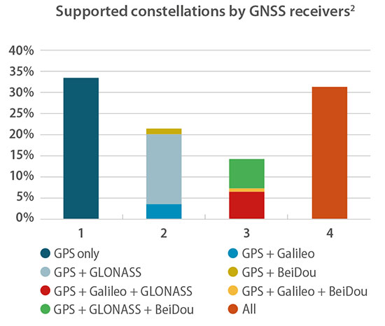
One remark in particular caught my eye as I read the press release précis of the European GNSS Agency’s 2018 GNSS User Technology Report. In point, “Today only around 30 percent of receivers use GPS only.”
“What?!?” methought. Incredulously, I downloaded the 92-page document, so easily done at www.gsa.europa.eu, and scrutinized it closely. Surely the GPS-only installed base out there is wider, vaster and deeper (it’s certainly older!) than could have been overtaken already by the wave of multi-constellation devices.
Yes, they are clearly the future. But is the past already gone? That golden age when GPS was all that anyone lived, positioned and navigated by — vanished into the mist?
Only earlier this very year was I upgraded from an iPhone 3 to an 8, with Galileo onboard for the first time. “Hip, but by the skin of my teeth,” I breathed.
Chart: GSA report
In the fine print on page 20 of the report lay clarification for my consternation. “For the analysis, each device is weighted equally, regardless of whether it is a chipset or receiver and no matter what its sales volume is. The results should therefore be interpreted as the split of constellation support in manufacturers’ offerings, rather than what is in use by end users.”
Of the roughly 500 chipsets and modules tallied by the GSA, 30 percent of those models are GPS-only. That’s a number of quite a different color. See the chart for fuller information.
Better minds than this can take a stab at how many devices in the hands end users on this day are still GPS-only. I’d put it above 50 percent.
The writing’s on the wall for the GPS-only artifact, but a good many of those veterans are still out there, working hard in the marketplace. Their reign as the majority may be limited, especially with the rising global tide of multi-constellation smartphones, but let’s honor them one last time before consigning them to the museum.
The GSA’s report, by the way, is a remarkably good and valuable read. No one can know it all, but this slim volume packs a remarkable and essential density of key facts, trends, issues, markets and more.
The toolset is a rapid-prototyping platform that lets product designers test and optimize the position accuracy and power consumption of wireless location tracking applications that use LTE-M and NB-IoT cellular networks, as well as GNSS technology. The toolset targets product engineers working on battery powered applications such as sport, people and asset trackers.
An increasing number of battery powered consumer and industrial products feature integrated GNSS receivers. These products include virtual reality headsets, smart watches, and devices to track elderly people, containers or parcels.
With the ongoing roll-out of low power wide-area cellular networks (LPWAN) such as LTE-M and NB-IoT technologies around the world and the extremely low power consumption they enable, the range of use cases for wireless location trackers is expected to expand further.
Screenshot: u-blox
“With today’s technology, product designers can now include optimized battery life in their applications,” said Florian Bousquet, product manager, Product Center Positioning, at u-blox.
“We developed this toolset to give customers a quick and easy way to test the accuracy and the power consumption of their product ideas using the latest generation of our technology,” he said. “In many cases, they can replicate their applications and start testing the performance of different device configurations in under 15 minutes.”
“The toolset offers access to the very latest technologies, from LTE-M and NB-IoT cellular communication to our proprietary Super-E mode(see video below) that delivers the best balance between power consumption and GNSS positioning performance,” he added.
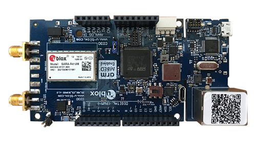
The u-track software runs from embedded firmware on the new u-blox C030-R410M application board. The board, specifically designed to rapidly prototype applications for the internet of things (IoT), includes an ultra-small, low-power u-blox ZOE-M8B GNSS receiver and a size-optimized SARA-R410M LTE-M/NB-IoT cellular communication module.
Additionally, u-track includes a PC software application. Its user-friendly dashboard lets users log, retrieve, and visualize power consumption, accuracy, and other important values, such as the time it takes the GNSS receiver to calculate a position (time-to-first-fix, TTFF).
The u-track and C030-R410M toolset will be showcased on Sept. 12-14 at Mobile World Congress Americas, u-blox Booth no S.2702.
Qianxun Spatial Intelligence Inc., a high-precision positioning service provider, and u-blox are joining forces to deliver high-precision positioning solutions to the Chinese market.
By coordinating their product offerings, they seek to meet growing demand for increased positioning accuracy for mass-market applications. Some of the areas driving up demand for high-precision positioning services in China are internet of things (IoT) tracking devices such as those used on shared bikes, as well as automotive, UAV and robotic vehicle applications.
u‑blox is bringing to the partnership its high-precision GNSS receivers. Its u‑blox F9 multi-band positioning platform uses integrated real-time kinematic (RTK) technology to process the high-precision positioning correction data provided by Qianxun SI, delivering down to centimeter-level positioning accuracy for wide-ranging applications. It enables even faster and more robust performance by leveraging a greater variety of GNSS signals.
Two major advancements have enabled sub-meter-level positioning accuracy for mass-market applications. The first is modern GNSS correction services that constantly monitor GNSS signals to determine positioning errors caused, for example, by atmospheric distortions, and wirelessly transmit correction data to compensate for these errors to millions of GNSS devices. The second is a new generation of small, power-efficient, and affordable GNSS receivers that are able to use the correction data to achieve such high levels of accuracy.
Qianxun SI, a high-precision positioning service provider, has already laid the groundwork for the large-scale expansion of high-precision positioning in the IoT era, the company said. Based on BeiDou, which is compatible with GPS, GLONASS and Galileo, Qianxun SI’s high-precision positioning service is built on the nationwide ONE Network, composed of more than 2,000 Continuously Operating Reference Stations (CORS) and using proprietary algorithms. It offers vehicles and other applications a range of 24/7 high-precision positioning services in most regions of the country.
By the end of 2018, Qianxun SI’s dynamic centimeter-level service will cover the entire mainland of China, the company said.
“We are delighted to cooperate with u-blox to provide users with high-precision positioning solutions that are user friendly and affordable,” said Jinpei Chen, CEO of Qianxun SI. “I believe our high-precision positioning technology is a key enabler of IoT development, and the cooperation with u‑blox will accelerate the go-to-market process of the technology in an extensive range of industrial and automotive market applications.”.
“This collaboration is a genuine win-win for all involved in that it allows us to develop high-precision solutions that will foster innovation across markets,” said Thomas Seiler, CEO of u-blox. “Partnering with China’s leading GNSS correction service provider allows u-blox customers to bring cutting edge applications to the China market in the shortest possible time.”
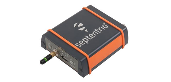
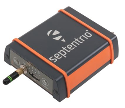
GNSS receiver manufacturer Septentrio is introducing its AsteRx SB at two industry shows: Expomin in Santiago, Chile (April 23-27), and Intermat in Paris, France.
According to the company, the AsteRx SB delivers Septentrio’s quad-constellation real-time kinematic (RTK) positioning in a low-power, IP68 compliant housing. Built around the AsteRx-m2 GNSS receiver engine, the AsteRx SB features Wi-Fi, Bluetooth, USB, Ethernet and serial connectivity.
Septentrio’s GNSS+ suite of positioning algorithms converts difficult environments into good positioning: LOCK+ technology to maintain tracking during heavy vibration, APME+ to combat multipath, and IONO+ technology to ensure position accuracy during periods of elevated ionospheric activity.
The AsteRx SB also features the AIM+ interference mitigation and monitoring system, which can suppress the widest variety of interferers, from simple continuous narrowband signals to the most complex wideband and pulsed jammers.
AIM+ interference monitoring and mitigation system
L-band PPP, RTK, scalable accuracy
High-update rate, low-latency positioning
Base and rover operation
Bluetooth, Wi-Fi, Ethernet, serial and USB communications
Whether exposed to the elements or inside a vehicle cab, operating alone or as a core component of a sensor-fusion system, the AsteRx SB is straight-forward to set up and integrate into any new or existing application. Using Wi-Fi or micro USB, the AsteRx SB can be configured and monitored using any device with a web browser.
“We believe the AsteRx SB is the best all-rounder on the market today. We’ve produced a small and low-power device with zero compromise on performance,” said Gustavo Lopez, product manager at Septentrio. “From machine control to sensor-fusion applications, manned or unmanned, the compact size and low power of the AsteRx SB along with its range of communications options make it ideal for any project requiring reliable high-precision positioning.”
At Intermat in Paris, Septentrio will exhibit at Booth 6H-041 and at Expomin in Santiago, Chile, at Booth 1K-30.
From April 1 onward, car manufacturers are required to equip new vehicles for sale in the European Union with an eCall module. In the event of a serious accident, this emergency call system automatically sends data to the uniform European emergency phone number 112 to facilitate faster response by emergency services.
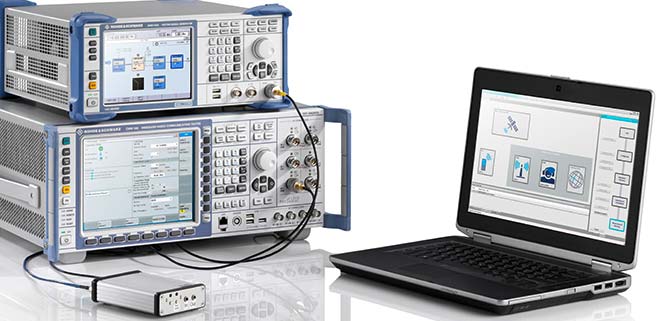
The independent test house CETECOM has now certified the eCall test solution from Rohde & Schwarz, which can be used to simulate a public-safety answering point, in accordance with the EN standard. This puts manufacturers and suppliers in a very good position for acceptance tests of their installed emergency call systems, and the Russian emergency call counterpart ERA-Glonass can also be tested with an extension.
The Rohde & Schwarz eCall test solution is the first of its kind to be certified by an independent test body, according to the company. CETECOM has examined the implementation of the eCall test public safety answering point (PSAP) in the Rohde & Schwarz solution for the pan-European emergency call system and certified it as compliant with the CEN EN 16454:2015 standard. This is a prerequisite for tests compliant with Commission Delegated Regulation (EU) 2017/79.
CETECOM has been officially designated as a technical service for eCall by the German Federal Motor Transport Authority. After March 31, manufacturers must equip new vehicles for sale in the EU with an eCall module. The R&S CMW-KA094 test solution is the first independently certified test PSAP system based on a wireless communications test platform.
Rohde & Schwarz thus offers a compact solution for reproducible end-to-end functional tests and standard-compliant conformance tests of eCall and ERA-Glonass modules. The prescribed conformance tests can be performed with the test solution.
Manufacturers and suppliers use these tests to check whether the installed modem properly initiates an emergency call in the event of a motor vehicle accident, correctly acquires the relevant data and sends it via the mobile network, and is able to establish a voice connection to the PSAP.
Test houses and vehicle manufacturers use this solution for type approvals and for other tests requiring the emulation of mobile networks, such as location-independent testing of a car telephone.
The certification of an eCall test solution by an independent body demonstrates that Rohde & Schwarz is a reliable partner for the automobile industry — the majority of global OEMs use the R&S CMW500 wideband radio communication tester and rely on the field-proven Rohde & Schwarz test solution.
The company is also developing test features for the next-generation eCall over LTE system and making the corresponding solution fit for the future and for testing new vehicle telematics units.
Along with eCall, Rohde & Schwarz supports the automobile industry with test solutions for V2X communications (from a vehicle to other users).
The eCall test solution based on the R&S CMW500 platform in combination with the R&S SMBV100A GNSS simulator is the first to be certified by CETECOM. (Photo: Rohde & Schwarz)
Technical basis. The R&S CMW-KA094 application software specifically developed for eCall is based on the R&S CMW500 platform in combination with the R&S SMBV100A GNSS simulator.
The software simulates a PSAP and controls the R&S CMW500, which emulates a mobile network in the lab. It also controls the GNSS simulator, which provides the position data of the accident location.
The R&S SMBV100A additionally supports the GNSS receiver performance tests in accordance with Commission Delegated Regulation (EU) 2017/79 Annex VI.
The eCall test solution can be fully automated with the R&S CMWrun sequencer software for further conformance tests, enabling users to directly utilize ready-made test sequences for eCall and ERA-Glonass modules compliant with ETSI TS 103 412, CEN EN 16454 or GOST 33467. This additionally facilitates demonstration of the functional capability of the overall system in accordance with Commission Delegated Regulation (EU) 2017/79. For more information on how to test eCall and ERA-Glonass system modules, visit www.rohde-schwarz.com/ad/press/ecall-cetecom.
Lear Corporation, a global supplier of automotive seating and electrical systems, has entered into a definitive agreement to acquire Israel-based EXO Technologies, a developer of GPS technology providing high-accuracy solutions for autonomous and connected vehicle applications.
EXO Technologies has operations in San Mateo, California, and Tel Aviv, Israel. Financial terms of the transaction were not disclosed.
EXO Technologies has developed core technology that addresses the need for high-accuracy positioning in a vehicle. Its proprietary technology works with existing GPS receivers to provide centimeter-level accuracy anywhere on the globe without the need for terrestrial base-station networks.
EXO Technologies offers a software-based GPS approach — PICO pinpoint positioning software — that enhances GNSS receivers. By correcting satellite orbit error and clock error, it eliminates the inherent error sources within navigation messages. Its algorithms reduce complementary errors and construct a full positioning solution.
The integration of EXO’s technology with Lear’s vehicle and connectivity expertise will enable a superior vehicle positioning solution, the companies say.
“EXO has developed technology that is essential for the future of connected and autonomous vehicles,” said Nuri Golan, EXO co-founder and CEO. “We are extremely excited to join the Lear family where we will provide unparalleled solutions for vehicle-to-vehicle, autonomous driving and other applications.”
“Lear is a leader in automotive connectivity solutions including Vehicle-to-Vehicle and Vehicle-to-Infrastructure communications,” said Matt Simoncini, Lear’s president and chief executive officer. “The acquisition of EXO Technologies will provide Lear with a differentiated technology to significantly improve GPS accuracy and reliability, thereby enhancing vehicle safety and enabling autonomous driving.
“The combination of EXO Technologies with Lear’s existing resources further strengthens our connectivity capabilities,” Simoncini said. “We see excellent growth opportunities for our E-Systems business as the proliferation of connected and autonomous vehicles will drive increased demand for improved accuracy and reliability in vehicle positioning.”
Septentrio debuted the AsteRx-m2a and AsteRx-m2a UAS GNSS OEM engines at Commercial UAV 2017, held Oct. 24-26 in Las Vegas.
The two new OEM boards provide precise and reliable multi-frequency, all-in-view real-time kinematic (RTK) positioning and heading — along with interference technology — with low power consumption, the company said.
Both boards are smaller than a credit card and feature Septentrio’s AIM+ interference mitigation and monitoring system. AIM+ can suppress a wide variety of interferers, from simple continuous narrowband signals to the most complex wideband and pulsed jammers.
The AsteRx-m2a board by Septentrio. Photo: Septentrio
Increasing levels of radio-frequency pollution, coupled with the intrinsic danger of self-interference in compact systems such as UAS, makes interference mitigation a vital element in any UAS system that uses GNSS positioning.
Both boards are designed to bring high-precision positioning and attitude to any space-constrained application. According to the company, both receivers are designed to serve as core components in any multi-sensor application.
The AsteRx-m2a UAS is aimed specifically at unmanned applications, bringing plug-and-play compatibility for autopilot systems such as ArduPilot and Pixhawk. Event markers accurately synchronize camera shutter events with GNSS time. The board can be powered directly from the vehicle power bus via its wide-range input.
The AsteRx-m2 UAS board by Septentrio. Photo: Septentrio
The AsteRx-m2a UAS works seamlessly with GeoTagZ software, providing offline re-processed RTK accuracy without the need for either ground control points or a real-time datalink.
“We’ve taken the hugely successful AsteRx-m2 and added a second antenna input for high-precision GNSS heading,” said Gustavo Lopez, OEM product manager at Septentrio. “No need to manoeuvre around in a figure of ‘8’ trying to initialise INS heading or find space or additional power for a separate INS module now. All you need is a second antenna and you’re good to go.”
Septentrio is located at booth 206 of Commercial UAV Expo 2017.
u-blox, Bosch, Geo++ and Mitsubishi Electric are establishing the joint venture Sapcorda Services to bring high-precision GNSS positioning services to mass markets, including autonomous driving.
Bosch, Geo++, Mitsubishi Electric and u-blox have created Sapcorda Services GmbH, a joint venture that will bring high-precision GNSS positioning services to mass-market applications.
The four companies recognized that existing solutions for GNSS positioning services do not meet the needs of emerging high-precision GNSS mass markets.
As a result, they decided to join forces to facilitate the establishment of a worldwide available and affordable solution for system integrators, OEMs and receiver manufacturers. Each partner brings its unique expertise to the joint venture Sapcorda Services.
Sapcorda will offer globally available GNSS positioning services via internet and satellite broadcast and will enable accurate GNSS positioning at centimeter level. The services are designed to serve high-volume automotive, industrial and consumer markets.
The real-time correction data service will be delivered in a public, open format and is not bound to receiver hardware or systems. More information will be made available later this year.
“We believe this initiative with Bosch, Geo++ and Mitsubishi Electric to create Sapcorda Services will bring a truly disruptive GNSS service offering to the market,” said Daniel Ammann, executive VP and co-founder at u-blox. “Key characteristics such as security, safety and mass-scalability, coupled with an attractive business model and an open approach — serving all interested GNSS receiver manufacturers alike — will be a game-changer across a large number of established and emerging applications.”
“We are looking forward to collaborating with our partners in this joint venture,” said Jumana Al-Sibai, member of the executive management of the Chassis Systems Control division of Robert Bosch GmbH. “Together, we want to create a GNSS positioning service that fully supports the requirements for positioning sensors in the automotive sector. Only with built-in safety and the highest levels of precision will we be able to make automated driving reality.”
“Geo++ anticipates defining the future of high precision positioning services with our partners at Bosch, Mitsubishi Electric and u-blox. The combination of the partners’ longstanding leadership in automotive and mass market solutions with Sapcorda’s commitment to push open formats will pave the way for a raft of next generation GNSS applications,” said Gerhard Wübbena founder & president of Geo++.
“Mitsubishi Electric aims to create a border-less global market for high-precision positioning systems where receivers will be able to enjoy real-time correction data services potentially interoperable with the Japanese government’s Centimeter Level Augmentation Service (CLAS) via the Quasi-Zenith Satellite System,” said Masamitsu Okamura, executive officer in charge of Electronic Systems at Mitsubishi Electric Corporation. “We believe that this venture will accelerate adoption of automated driving and safe driving support.”
The Belgian dredging, environmental and engineering group DEME relies on the accuracy and reliability of the AsteRx family of precise GNSS positioning solutions from Septentrio.
DEME is using Septentrio’s AsteRx GNSS receivers to obtain centimeter-level accuracy for all its dredging and marine construction operations worldwide. These receivers are specifically designed to operate in difficult conditions, from dredging a few meters from the coastline to constructing wind turbines kilometers out at sea.
AsteRx-U dual-antenna receiver.
DEME began using Septentrio’s solutions more than 10 years ago. While dredging in the Belgian town of Oostende, DEME was unable to obtain a reliable RTK position from their GNSS equipment because of interfering radio signals from a local radio tower.
Septentrio worked with DEME to identify the source of the interference and modified a standard RTK receiver with special firmware to address the jamming problem. This case, along with others faced by Septentrio’s customers in the field, encouraged the development of a dedicated interference mitigation technology called AIM+, which is now standard in Septentrio’s GNSS solutions.
Septentrio’s AsteRx GNSS receivers have been deployed on DEME’s ships around the world. They have been vital to DEME for the success of projects such as the creation of Gateway Port in London, U.K.; the construction of Deurganckdok in Antwerp, Belgium; the Pearl Qatar City; the Thornton Bank Offshore Windfarm in Belgium; the extension of the Suez Canal in Egypt; and many more.
“’Creating land for the future’ is the slogan here at DEME and this is thanks, in part, to the accuracy and robustness of the solutions offered by Septentrio,” says Lorentz Lievens, head of the survey department.
“Jamming is a concern which DEME has seen more and more all over the world,” Lievens says. “Septentrio’s receivers are unique in that they continue to provide an accurate solution even in areas of high radio and ionospheric interference allowing DEME to deliver projects on time and on budget. Septentrio’s precise positioning solutions will remain vital for DEME to deliver quality and cost-effective operations around the world for many years to come.”
What lies ahead in the GNSS chipset and receiver domain, and what are the trends sure to transform the GNSS landscape of tomorrow? To answer those questions, the European GNSS Agency (GSA) has released its first GNSS User Technology Report.
In recent years, GNSS technology has experienced a period of rapid development — both on the side of global constellations and user receivers. With this development, European systems such as EGNOS and Galileo are becoming increasingly present in GNSS receivers, providing enhanced performance to users both in Europe and worldwide. Even with the increased deployment of other positioning technologies, because it is the most widespread and cost-effective source of location information, GNSS will remain at the core of all positioning technology.
“In view of the changing user needs in terms of expected positioning experiences, the appearance of new and modernized GNSS signals, and advances in semiconductor technologies, we felt the need to take a closer look at the impact these changes will have on user technology and GNSS’ role in the positioning solutions of the future,” said GSA Executive Director Carlo des Dorides.
A closer look
The outcome of this closer look is the GSA’s first GNSS User Technology Report. As a sister publication to the GNSS Market Report, the GNSS User Technology Report zeros in on the state-of-the-art GNSS receiver technology, along with analyzing the trends that are sure to change the entire GNSS landscape.
The report provides an in-depth analysis of GNSS user technology as it pertains to:
mass-market solutions
transport safety and liability-critical solutions
high-precision, timing and asset management solutions.
In addition, the report gives a general overview of the latest GNSS receiver technology, common to all application areas, along with a supplement on location technologies that looks beyond GNSS in the positioning landscape.
Written with contributions from leading GNSS receiver and chipset manufacturers, the GNSS User Technology Report is meant to serve as a valuable tool to support planning and decision-making in regards to developing, purchasing and using GNSS user technology.
“GNSS user technology is, now more than ever, experiencing a rapid and exciting evolution, answering the needs of ubiquity, automation and secure positioning,” said des Dorides. “This report explores in detail all of these new developments and how they will bring continuous location service, reliability and robustness to the main application domains.”
Among the findings:
Nearly 65 percent of all chipsets and modules currently on the market support multiple constellations.
Within the next few years, it is expected that 100 percent of all new devices will be multi-constellation capable.
The leaders in multi-constellation capability are mass-market receivers and high-accuracy professional receivers, with nearly 30 percent already capable of using the four available global constellations.
Receivers targeting such safety-critical applications as aviation must wait for new technologies to be proven and new standards or regulations to become available before implementing them.
In terms of supported frequencies, 30% of all receivers implement more than one frequency, mostly in high precision.
With the increasing demand for better resilience across all applications, the need for higher accuracy and integrity that automation demands, adoption of dual-frequency solutions (E1/L1 + E5/L5) is expected to grow.
In the mass market, the chipset supply chain is extremely consolidated, with a few players worldwide driving innovation.
For liability and safety-critical transport solutions, a consolidated industry with an important European presence dominates innovation in automotive, maritime and aviation, while new players are expected to emerge in such new applications as autonomous vehicles.
In high precision, timing and asset management, the suppliers are specialized in various professional fields, although their products are based on a relatively low number of GNSS chipsets.
Back again in Portland, Oregon, the 2016 Institute of Navigation’s ION GNSS+ conference was a great opportunity for the GNSS community to catch up on what’s been cooking in the industry, and of course who’s been doing what in the research community.
The attendees eagerly took to a wide range of technical paper presentation sessions, and from time to time came to take a look at what industry had to offer on the exhibit floor. Lots of engaging research reports, from work undertaken over the last year by academia, again drew a significant number of attendees from around the world.
On the other hand, industry continued the trend to go to trade shows in application sectors and pull back somewhat from ION GNSS+ as a place to look for product sales. So the number of companies on the ION show floor remained around the same or maybe a little less than in the previous few years. Nevertheless, the quality of the companies exhibiting remained high and there were some interesting newcomers.
A number of major GNSS receiver manufactures have pulled back from ION, so there were only two established U.S. companies and two new U.S. entrants at the show. On the other hand, GNSS simulation companies were at ION in force — eight all told, or twice as many as the receiver manufacturers present who have been their historic customers. But the trend in GNSS simulation now appears to be to move down stream towards the needs of integrators and systems outfits — in segments such as automotive, UAV and agriculture — with lower cost, very capable simulators.
Receiver makers roll out new tech
As a consequence, the NovAtel and Septentrio booths got a lot of attendee traffic, while BDStar (Unicore receivers and Harxon antennas) and ComNav also had a number of visitors to their booths. As usual, NavTech, who represent almost all the manufacturers, also had a busy exhibit.
OEM7600 dual-frequency receiver.
NovAtel chose to launch its OEM-7 series of GNSS receivers and a newly designed VEXXIS high-precision antenna at ION GNSS+, which is a somewhat refreshing return to the ION GNSS+ launch platform we used to see in the past. A new highly integrated ASIC at the heart of this receiver now provides, amongst other features, 555 channels, L-band support, inertial SPAN capability and an intriguing “Interference Toolbox”. The toolbox enables integrators to localize interference effects over a wide band — especially helpful for densely packed electronics, which you might expect in a UAV, for instance.
Interference Toolbox Screenshot.
Septentrio didn’t have a whole lot of new product announcements, but as usual the company has been working hard at improving existing capabilities on its receivers. The AsteRx4 receiver that uses a new ASIC has been available for a while, but it too boasts 544 channels — perhaps too many to actually be used in practice — robust heading, centimeter-level RTK and decimeter-level PPP (with TerraStar and Veripos corrections) with dual L-band channels, and an improved suite of advanced interference mitigation (AIM+) capabilities. This helps detection and removal of the effects of “chirp jamming” from low-power “cigarette-lighter” jammers — using signal analysis and adjustment of adaptive notch filters.
Septentrio did announce a new PolaRx5TR packaged time-and-frequency transfer receiver and a contract with the Jet Propulsion Laboratory (JPL) for reference stations and timing. A report by UNAVCO also found its way into my inbox, which related comparative testing of the PolaRx5 and other manufacturers’ receivers in connection with a UNAVCO RFP – Septentrio did O.K. and was selected as a preferred vendor, which no doubt influenced the JPL award and added to an already good first half year for the company.
The Septentrio PolaRX5TR.
BDStar had a range of GPS, GLONASS, Beidou receivers from its subsidiary Unicorecomm, along with an impressive selection of antennas from Harxon, another of its Chinese subsidiaries. Both product lines have done very well in the Chinese market, and BDStar would like to sell more in North America.
ComNav also displayed a similar range of GNSS receivers and antennas, with new versions of both since last year, and a strong desire to break through into the US market.
Simulators a big presence
Simulator companies at ION included the more established Spirent, Spectracom, CAST, IFEN and Rohde & Schwarz — we could even now consider RaceLogic/LabSat as a record-and-playback fixture in the market. But in the wings and making lots of waves at the show were Syntony from France and Skydel from Montreal, Canada.
Spirent brought its usual large-scale GNSS simulators to ION, but also featured an interference detection and software analysis suite, a 16-bit high-fidelity record/playback unit, along with a new multi-frequency simulator aimed at downstream integrators. The GSS200D Detector finds interference effects and is able to relate them to the threats in the environment around a receiver. The object is to help debug an installation by finding internal interferers. The analysis tools can also help differentiate between regular equipment interference and potential external jammers.
Spirent’s new GSS200D detector.
Spirent also displayed a record/playback unit that has 16-bit playback capability, enabling a user to record and review a particular interference event, and then feed their new commercial simulator in order to replicate the interference. So a passing isolated jamming event can be analyzed in detail. Multiple reruns are possible to confirm the effect on the target system, and following equipment modifications, prove that the problem has indeed been neutralized.
Spirent analysis tools.
RaceLogic introduced its new wideband LabSat 3 record/playback system for GPS L1, GLONASS L1, Galileo E1, BeiDou B1, QZSS and SBAS. Recording live signals for any or all of these signals then allows later playback of a canned sample for equipment debugging on the bench. The LabSat product line has been around for some time, and this addition increases the debug capability for downstream users at an affordable price in a very portable format. When used with the RaceLogic SatGen software system, the user has access to a powerful toolset for testing new GNSS devices.
LabSat 3 and SatGen test set-up.
Spectrcom displayed its multi-frequency, multi-constellation simulator and also featured a GNSS vulnerability test system for interference detection and system debugging. The company’s approach requires two simulators, both synchronized by an atomic clock, allowing a PC-based Test Scenario Control to generate reproducible interference effects for debugging.
CAST Navigation is already moving downstream quite quickly with its CAST-SGX handheld GNSS simulator. With a touchscreen display, this simplified L1 GPS simulator (with P-code option) is ideal for test-bench debugging.
Rohde & Schwarz had its usual array of high-end test equipment, with a test set-up aimed at demonstrating testing of a Wi-Fi indoor location application on a smartphone.
IFEN showed up with a completely re-engineered simulator with huge frequency/channel capacity. The Titan GNSS Simulator houses up to 8 RFSIM modules, each of which carries 32 configurable satellite signals. A fully configured Titan chassis can therefore provide 256 channels of GPS L1/L2/L5, GLONASS G1/G2/G3, Galileo E1/E5/E6, Beidou B1/B2/B3, IRNSS L5 and S-band, QZSS L1/L2/L5/LEX and all current L1/L5 SBAS signals. Titan also has up to four independent RF outputs.
IFEN Titan GNSS Simulator.
Skydel is one of the newcomers in GNSS simulation, but has made significant inroads first appearing last year at ION. Skydel now boasts a full-up, reconfigurable GPS, GLONASS, Galileo, Beidou “software” simulator which the company claims to sell at a 1/3 the price of a conventional hardware simulator. And during the year, Skydel teamed up with Talen-X in Ohio, who have embedded Skydel software-defined in a U.S.-sourced GPS/GLONASS/Galileo/Beidou simulator that can include GPS P/Y and M-code.
Broadsim from Talen-X powered by Skydel.
Syntony rises high by going under (the ground)
The noise in simulation at ION was, however, created by Syntony from Toulouse in France. Syntony recently won a 15-simulator order from OneWeb — the outfit that plans to launch a 640 internet connectivity satellite constellation through 2020. With funding secured from Virgin Group and Qualcomm in 2015, initial satellite build is underway at Airbus Defence and Space, launch services are contracted with Arianespace to provide 21 multi-sat launches on Soyuz beginning in 2017 with optional launch service with Virgin Galactic. So Syntony is likely going to be able to build, deliver and be paid for its 15 simulators, which will be used for testing GPS capability that is integrated into each comms satellite.
Syntony’s simulator is also software-defined and is reconfigurable. The software-defined heart of this system comes from a Syntony GPS/Galileo receiver, and a version of this receiver has now been sold for use in the Airbus Adeline re-usable space module. This receiver is a “multi-antenna receiver” in order to avoid signal or tracking loss while switching between antennas during the Safran launcher rotation. The catch here is that Syntony must develop this receiver to Airbus critical airborne software=qualification standards — no mean feat! Syntony is also providing a version of its Constellator simulator for testing this multi-antenna input receiver.
An ECHO record/playback system is also available, which includes high-fidelity 16-bit RF outputs.
Finally, Syntony was able to capture a proof-of-concept location infrastructure project for Stockholm, Sweden’s, underground metro. The metro stations are pretty deep underground, as they have been dug under the sea in and around Stockholm, and no one had been able to come up with a system that would enable emergency 911 calls with associated essential localized position information to be carried from within the stations. Syntony was able to provide a GPS-like signal infrastructure at the stations which is compatible with GPS-enabled smartphones. It worked well, and Syntony verified that there was no radiation of the signal outside any of the entrances to the test station — so no GPS interference. It actually worked so well that Syntony got the contract to equip all 50 metro stations in Stockholm, and the Syntony is now working to spread its system around the metros of all major cities, worldwide.
Defining the Galileo PRS signal…
Then I came across Fraunhofer towards the end of the show, and their posters about a Galileo PRS (Public Regulated Service) receiver. Now, we know that there has been significant discussion between the different security services of countries across the European Union, and its taken a lot of time to get to a definition of the PRS signal and who has access. So it wasn’t surprising that there was no hardware on the Fraunhofer booth; what’s surprising is that there was any mention of such a receiver being available and telling attendees at a conference in the U.S. that it’s available.
I talked to a couple of people at their booth, and indeed there is such a receiver, but they really couldn’t tell me anything about it because telling is strictly verboten! Another strange anomaly of the Galileo program — the participants seem to want to let the U.S. know that they have the capability for a special access service, and a receiver is available to work with it, but they can’t tell us anything about it. I guess the idea may be to rattle the cage of the U.S. P-code/M-code guys, and let them know Galileo has caught up at last… But Fraunhofer has an idea of how to make things available to, well, err …. to somebody. They have a concept to have cellphone users who want PRS to connect with their cloud receiver, and they will decode and provide PRS position back over the internet. That solves the whole security thing…. OK, that should do it.
Where inertial stands
I also made the rounds of the inertial and inertial/GPS guys at the show, and there were quite a few. From NorthropGrumman and Systron Donner and their mil-spec high-end FOG and RLG and Quartz MEMS tube-shaped inertial units — could they be for shells or missiles? — to Silicon Sensing’s MEMS accels and gyros and their move out of automotive and towards high-precision performance, to Sensonor’s high-performance commercial MEMS/GNSS units, there were actually only a few of the inertial-aiding outfits present. Yet everything we hear is that for anything that moves, we really should use integrated inertial/GNSS, and UAVs especially want lots of that! So this part of the business looks to be quite healthy too…
Now another ION GNSS+ conference has come and gone — and I was reminded that maybe I’ve actually been to 95 percent of the ION September conferences over the last 30 years. And as I write, the last of the late Friday paper sessions are crawling to a close.
ION still remains a good place to come and learn, a place to meet industry colleagues and a place to see a little of what industry is up to. Definitely worth the trip, and don’t forget your business cards next year.
Broadcast Date: February 18, 2016 On-Demand Available Until: February 18, 2017 Sponsor:NovAtel Summary: Our expert panel will discuss the use of RF detection system-equipped UAV jammer hunters, the performance of null-steering techniques for GNSS receivers and more in this one-hour webinar. Speakers: Adrien Perkins, Stanford University and James T. Curran, Ph.D., European Commission