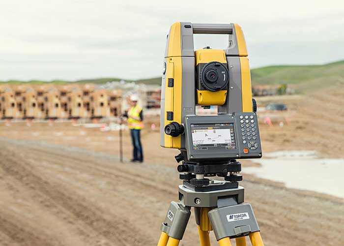
The new the GT series of total stations are part of a full workflow solution, including a new field computer, a full-version update to Topcon field and office software and GNSS receivers. The system is designed to work in sync for improved performance and better data handling with built-in, field-to-office connectivity.
The speed, tracking and accuracy of the GT series, combined with the intuitive software system, creates a flexible solution capable of satisfying the technology needs of surveyors and contractors performing survey, layout or machine guidance projects, Topcon said.
“The new total stations perform at a faster 10-Hz positioning update rate,” said Ray Kerwin, director of global product planning. “Combining the GT series with the new field computer and software enhancements, this tracking improvement makes layout easier and guidance more fluid, within an intuitive map view. More layout and survey points can be collected in less time.”
“Surveyors, contractors, as well as heavy machinery automation operators and other construction professionals can benefit from the time-savings and accuracy the series provides,” Kerwin said.
Advanced UltraTrac prism tracking combines optical sensing with a new ultrasonic motor control algorithm designed to maintain superior prism lock.
“Tracking fast-moving targets and maintaining prism lock is now easier on challenging job sites as well as in machine guidance applications. If you’re performing a machine control project where the prism is vibrating on the end of the blade, for instance, the GT will lock onto the prism better and provide smoother machine guidance,” Kerwin said.
Magnet software improves field-based quality reporting and data handling for larger files, graphical processing, and 3D models. Magnet Field features more visual- and map-based workflows in addition to menu-driven functionality popular with power users.
An optional upgrade incorporating hybrid positioning technology helps advanced users get instant location updates via GNSS receivers so positioning data points can be captured, even with the loss of line-of-sight from job site obstructions.
The complete GT series workflow solution — Magnet software, FC-6000 field computer, and HiPer Series GNSS receivers — combine for easy-to-use digital processes designed to help surveyors and contractors increase precision, reduce rework and improve quality control.
Parked cars near ground station decreased accuracy from 2 to 4 centimeters
A new study shows that the quality of GNSS reflectometry measurements may have improved significantly during the pandemic because of the lack of cars parked near the ground station, according to Science Daily. GNSS reflectometry is used for earthquake early warning systems, determining flood risks, and many other geodesy applications.
The study, carried out by geodesists from the University of Bonn, investigated the location of a precise GNSS antenna in Boston, Massachusetts.
GNSS reflectometry works well if the surrounding ground is flat, like the surface of a mirror, study author Jürgen Kusche explained to Science Daily. “But many GNSS receivers are mounted on buildings in cities or in industrial zones. They are often surrounded by large parking lots — as is the case with the antenna we investigated in Boston.”
The researchers show that parked cars significantly reduced the quality of the elevation data by scattering the GNSS signals, causing them to be reflected several times before they reached the antenna, like a cracked mirror. This reduces signal intensity and provides “noisy” data — hard to correct with pattern recognition because the parked cars change positions every day.
“Before the pandemic, measurements of antenna height had an average accuracy of about 4 centimeters due to the higher level of noise,” Makan Karegar told Science Daily. “During the lockdown, however, there were almost no vehicles parked in the vicinity of the antenna; this improved the accuracy to about 2 centimeters.”
While GNSS stations were historically installed in sparsely populated regions, recent installations have been in urban areas to support engineering and surveying work.
“Our study recommends that we should try to avoid installation of GNSS sensors next to parking lots,” Karegar said.
Citation. Makan A. Karegar, Jürgen Kusche. Imprints of COVID‐19 lockdown on GNSS observations: An initial demonstration using GNSS interferometric reflectometry. Geophysical Research Letters, 2020; DOI: 10.1029/2020GL089647
A GNSS jamming trial will take place from Sept. 8 through Dec. 4 in and around Luce Bay, at Wigtownshire in southern Scotland, conducted by the United Kingdom’s Civil Aviation Authority.
The trial will affect electronic situational awareness devices, UAS command systems and GNSS receivers.
The activity may affect GNSS receivers along with UAS and cockpit devices operating on 433, 868, 915, 2400, 5800 MHz operating up to 40,000FT AMSL within 55NM of 545020N 045548W (West Freugh).
During the trials, impacted systems may suffer intermittent or total failure. Individual events will not exceed two minutes in duration with no more than five events per hour. Activity will take place in the daytime hours between 0830 and 1600.
Current u-blox GNSS platforms — from u-blox M8 and beyond — support the recently completed BeiDou navigation satellite system modernizations, improving the availability of GNSS positioning services.
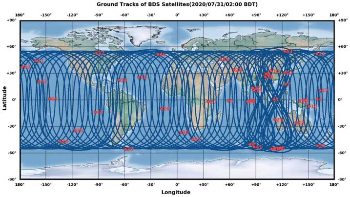
The opening ceremony of the BeiDou-3 global navigation satellite system (GNSS) was held in Beijing on July 31, officially celebrating the expansion of coverage offered by the critical Chinese space infrastructure to a global user base.
As a global supplier of GNSS positioning and wireless communication technologies, u-blox has been driving technological innovation and deeply involved in the Chinese market for many years.
Tests conducted across China and Europe have shown that including the BeiDou system can improve the positioning accuracy of GNSS receivers when multiple navigation satellite systems are tracked concurrently. When signals are partially obstructed, positioning accuracy can be significantly improved by incorporating the BeiDou system.
Data shows that in 2019, the overall output value of the Chinese satellite navigation and location service industry reached nearly 345 billion yuan, an increase of 14.4% over 2018, with the output value expected to exceed 400 billion yuan in 2020.
Graphic: China Satellite Navigation System Management Office Test Evaluation Research Center
Additional Services Provided by BeiDou
The BeiDou system provides a suite of additional services, including satellite and ground-based augmentation services, precise single-point positioning, precise timing and global short message services, laying a solid foundation for BeiDou’s ubiquitous navigation and tracking applications.
Applications of GNSS technology continue to diversify, leveraging the all-weather, all-time, tracking, navigation and timing services it offers. GNSS technology is penetrating deeper into traditional industrial verticals, such as agriculture, forestry, animal husbandry and fishery, power and energy, as well as in railway and air transportation, including their infrastructure construction and management.
At the same time, GNSS technology has become an indispensable and “smart” factor in emerging application fields such as the internet of things and the “internet of vehicles,” as well as in innovative applications such as autonomous driving, automatic parking and automatic logistics, and is now commonplace in many industrial and consumer use cases.
“U-blox has been closely following the modernization of the BeiDou navigation system and is ready to work with partners in various industries to promote the expansion of industry applications, expand emerging markets and jointly create a green industry ecosystem,” said Hamilton Chen, China country manager at u-blox.
Effective July 2, the Brandt Group of Companies successfully acquired the assets of Ontario-based Sokkia Canada in a deal with owner Topcon Positioning Systems.
The acquisition, which directly affects the Ontario and Quebec markets, makes Brandt the exclusive dealer for Sokkia optical survey instruments, accessories and parts for the Canadian market.
The news signals Brandt’s entry into Central Canada’s geopositioning technology market and is the latest in a growing list of acquisitions and dealer agreements made by the Regina, SK-based company since its purchase of Ontario/Quebec/Newfoundland and Labrador John Deere Construction & Forestry dealer Nortrax in late 2019.
“Expanding our Sokkia offering into Ontario and Quebec has been a high priority for Brandt,” said Brandt CEO Shaun Semple. “Central Canada is an important new market for us and we are 100% committed to delivering exceptional value for the survey, engineering and construction industry here. This addition is a big step forward for us.”
The survey-focused Sokkia brand has a 100-year history and is owned and marketed by Topcon Positioning Systems, a U.S.-based division of Japanese precision equipment manufacturer Topcon Corporation.
The Sokkia product lineup will be distributed and supported through the company’s Brandt Positioning Technology division and includes total stations, GNSS receivers, data collectors, digital levels and a full complement of field accessories.
The move will consolidate Sokkia distribution for the first time under one banner and will further establish the Brandt’s position as a premier privately-held Canadian company.
The Brandt Group of Companies — headquartered in Regina, Saskatchewan, Canada — is comprised of Brandt Agricultural Products, Brandt Engineered Products, Brandt Equipment Solutions, Brandt Road Rail, Brandt Positioning Technology, Brandt Truck Rigging & Trailers, Brandt Finance, Brandt Developments Ltd., Brandt Road Technology, Brandt Mineral Technology and Brandt Tractor Ltd. (the world’s largest privately owned John Deere Construction & Forestry equipment dealer.)
Brandt has more than 100 locations in Canada and the U.S., more than 3,400 employees, and a growing international customer base. It serves the construction, forestry, agriculture, rail, mining, steel and energy industries.
Trimble GNSS integrates with PointMan field applications to identify, capture and record the precise geospatial location of utilities
ProStar has joined Trimble’s GIS Business Partner Program. As part of the program, ProStar has implemented the Trimble Precision SDK (software developer kit) to integrate high-accuracy positioning capability in its PointMan mobile application running on smartphones and tablets using Trimble GNSS receivers.
ProStar provides field crews with an easy-to-use mobile data collection solution designed to capture, record and provide real-time visualization of the precise locations of subsurface infrastructure, while utilizing a centralized database to permanently and securely store and share utility location records in the cloud.
By adding the Trimble R Series and Trimble Catalyst receivers to the ProStar workflow, users can confidently access high-quality data and identify potential conflicts to avoid accidents, disruption of services and costly delays to infrastructure projects impacted by not knowing the precise locations of buried utilities.
“Together, Trimble and ProStar are changing the way construction companies, engineering and surveying firms as well as government transportation agencies capture, store and utilize utility infrastructure data. By leveraging the power of geospatial technology, they are able to make more informed decisions in the field,” said Stephanie Michaud, strategic marketing manager, Trimble Survey & Mapping field solutions. “Through this collaboration with ProStar, we are committed to integrating Trimble technology into ProStar’s cloud and mobile solutions to enhance safety protocols on site, reduce project costs and make a safer work environment.”
“We’re excited about this new collaboration and the integration of our PointMan software with Trimble’s high-accuracy GNSS receivers,” said Page Tucker, president & CEO of ProStar. “Creating a seamless integration with Trimble high-accuracy receivers and our PointMan software is a game-changer that will now provide one of the most comprehensive and precise field data collection solutions in the industry.”
About ProStar
ProStar specializes in the development of Precision Mapping Solutions. ProStar’s Solution is natively cloud and mobile and offered as Software as a Service.
ProStar’s Solution is designed to improve the business operations of any industry that requires the precise location of sub-surface infrastructure including utility, oil & gas, construction, engineering & surveying, 811 and contract locating.
ProStar’s Solution enables real-time access to precise location information including in the office and out in the field. Knowing the type, precise location and condition of what lies below the earth’s surface can significantly decrease liabilities and increase productivity during construction and maintenance activities.
The driver, developed by NovAtel engineers, provides an optimized interface enabling users to accelerate autonomous development projects by quickly incorporating NovAtel OEM7 receivers into custom applications.
The driver is available for immediate download through the new NovAtel GitHub repository or as a ROS Binary Package for direct installation.
With the release of a NovAtel-developed OEM7 driver built on ROS, developers can now confidently access the critical data needed to build autonomy algorithms for academic investigations, ride-share programs, and other applications.
Data from numerous sensors can be combined to help move projects into higher levels of autonomy faster without the need to adapt community-developed drivers. Tested using the Hexagon | AutonomouStuff platform, the driver ensures that the data received accurately reflects the output provided by the receiver, while also giving users the ability to record raw data for post-processing.
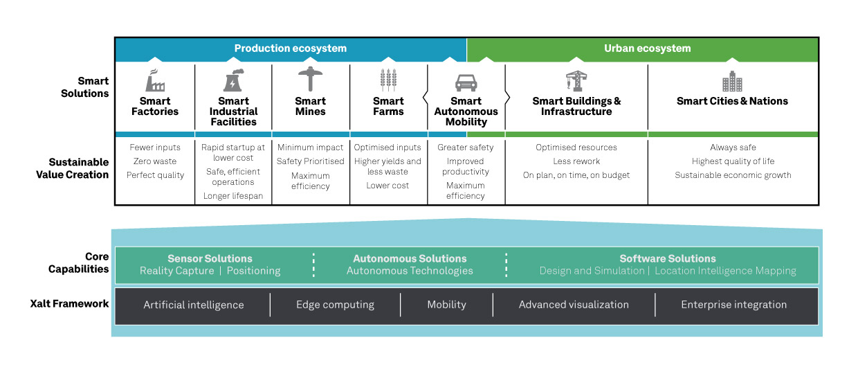
“We are excited to introduce our first purpose-built driver powered by ROS to the GitHub community. Its development is a result of collaboration between NovAtel and AutonomouStuff in support of Hexagon’s Smart Autonomous Mobility (SAM) initiative, unveiled at CES 2020 in Las Vegas,” said Miguel Amor, chief marketing officer, Hexagon’s Autonomy & Positioning division. “The SAM portfolio is a comprehensive solutions platform that brings together all the necessary sensors, software and services to make autonomous driving possible.”
The new driver is available for download on the NovAtel GitHub repository.
Septentrio has entered into a commercial agreement with Sapcorda, a global provider of sub-decimeter GNSS corrections.
Through the collaboration with Sapcorda, Septentrio will pioneer an no-hassle corrections integration into a new line of products for the high-accuracy industrial market.
These new products will consist of Sapcorda’s SAPA Premium corrections integrated directly into Septentrio’s latest GNSS receiver technology. The result is sub-decimeter accuracy, which is available to users right out of the box. This significantly simplifies the user’s GNSS receiver set-up process and eliminates the hassle of corrections service subscription and maintenance.
Such GNSS receivers acquire corrections via internet as well as via satellite broadcast and deliver reliable, broadly available sub-decimeter positioning to high-volume industrial applications.
Sapcorda integration program
Sapcorda release its SAPA augmentation service integration program on May 14, following the launch of its SAPA Premium service. The integration program targets companies integrating GNSS chips or receivers and looking to enable their systems to perform in high-accuracy mode.
The program offers step by step service integration and proof of concept guidance for upgrading the integrators’ GNSS systems to deliver down to centimeter-level positioning accuracy.
The program also includes the offering of free service data, used to validate positioning performance on the target application. The program participants also receive commercial support for introducing the correction data on their marketed products.
The SAPA service is delivered using optimized data format and can be integrated by modern or traditional high-accuracy receivers compatible with open standards such as SPARTN and RTCM.
Sapcorda’s SAPA services are designed to bring high-precision GNSS positioning to mass market, as well as general industrial and automotive applications. The correction data stream is optimized for homogeneous performance and end-to-end data security with continental coverage in the United States and Europe.
The service data transmission also provides unmatched low bandwidth consumption, with broadcast transmission via direct IP connection or geostationary satellite signal (L-band).
Sapcorda was established in 2017 to provide an open approach to a safe, broadly available and scalable corrections service. By adding Sapcorda’s SAPA service to its corrections portfolio, Septentrio begins offering sub-decimeter accuracy with quick convergence time anywhere in the U.S. and Europe.
Autonomous vehicles, robots
“This collaboration allows both companies to bring innovative solutions, inspired by the growing market of autonomous vehicles and robots, to the high-accuracy industrial markets,” said Jan van Hees, business development director at Septentrio. “By integrating Sapcorda’s SAPA service into our products, we are completely removing the hassle of managing corrections for the customers. This means faster set-up times and worry-free, always-on high-accuracy positioning throughout the whole receiver lifetime.”
“At Sapcorda our focus is on providing a high-accuracy service suitable for demanding applications where both performance and safety is critical. This includes land robots, UAVs, logistic applications and autonomous vehicles,” said Botho Graf zu Eulenburg, CEO at Sapcorda. “Septentrio’s field-proven high-precision GNSS receivers and their focus on reliability and robustness aligns perfectly with our mission and the capabilities of our SAPA services.”
This broadens the range of Septentrio’s existing GNSS solutions, allowing the company to serve a wide range of customers with various requirements in terms of accuracy, operation location and scalability. Read Septentrio demystifies GNSS corrections for more about GNSS corrections and correction methods such as Sapcorda SAPA (PPP-RTK) service.
Qinertia, SBG Systems’ PPK software, now supports third-party IMUs and offers a GNSS post-processing license covering all major GNSS receivers
Screenshot: SBG Systems
SBG Systems’ INS/GNSS post-processing kinematic (PPK) software Qinertia now covers all surveyors’ projects by offering a license dedicated to GNSS post-processing. Open to the world, Qinertia supports all major GNSS receivers and is now open to third-party inertial measurement units (IMUs).
Qinertia has been designed to offer a comprehensive suite of post-processing software to geospatial professionals. It accepts all major GNSS manufacturers, and supports proprietary protocols from NovAtel, Septentrio, Trimble and u-blox for a straight-forward workflow.
The full-featured post-processing software offers native support for u-blox F9 real-time kinematic (RTK) receivers, reducing the workflow to a simple “drag and drop” to guarantee data integrity and accuracy.
Qinertia has been designed to help surveyors get the most of their surveys easily with a simple workflow, powerful quality control tools and tightly coupled algorithms. All of this is available to any surveyor with the new support of third-party IMUs or GNSS receivers. Several IMUs and inertial navigation systems (INS) have already been successfully integrated with Qinertia including Northrop Grumman’s LN-200 and LCI-100 and the Inertial Sense µIMU.
The new Qinertia GNSS license allows surveyors to post-process both static and kinematic GNSS data. In just a few clicks, surveyors can improve their trajectories, access RTK corrections worldwide, or even control a base-station’s precise location using precise point positioning (PPP) static computations.
GIS and Photogrammetry. Whether they fly a UAV or drive a car, professionals can improve their image location accuracy. Qinertia has been designed to help surveyors get their GIS or photogrammetry projects way more precise, by exporting a centimetric position for each picture at the exact shutter event.
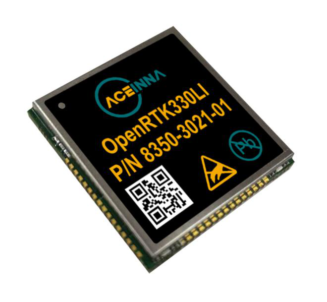
The Aceinna OPENRTK330L integrates a triple-band RTK/GNSS receiver and a triple-redundant inertial sensor to enhance the safety of autonomous systems.
Photo: Aceinna
Aceinna is now shipping its OPENRTK330L, a cost-effective module designed for developers creating mission-critical guidance and navigation systems for autonomous vehicles, including robots, drones, industrial, construction and agricultural machinery.
Aceinna designed the OPENRTK330L to replace expensive and bulky precision RTK/INS systems used in today’s autonomous systems.
The OPENRTK precise positioning engine optimizes satellite tracking and high RTK fixes rates while integrating seamlessly with Aceinna’s open-source Open Navigation Platform.
ACEINNA’s OPENRTK330L includes a triple-band RTK/GNSS receiver coupled with redundant inertial sensor arrays to provide centimeter-level accuracy, enhanced reliability and superior performance during GNSS outages. It integrates a precise 1.5-degree/hour inertial measurement unit (IMU) to offer 10 to 30 seconds of high accuracy localization during full GNSS denial.
The OPENRTK330L’s embedded Ethernet interface allows easy and direct connection to GNSS correction networks around the world. OPENRTK330L’s CAN bus interface allows simple integration into existing vehicle architectures.
The multi-band GNSS receiver can monitor all global constellations (GPS, GLONASS, BeiDou, Galileo, QZSS, NAVIC, SBAS) and simultaneously track up to 80 channels. The module has RF and baseband support for the L1, L2 and L5 GPS bands and their international constellation signal equivalents.
By integrating a triple-redundant IMU array, the OPENRTK330L is able to recognize and utilize only valid sensor data, ensuring high-accuracy protection limits and certifiability under ISO26262 standards. ACEINNA’s triple redundant 6-Axis IMU array uses a total of 9 accelerometer and 9 rate gyro channels.
The OPENRTK330L is supported by ACEINNA’s Open Navigation Platform, allowing custom-embedded application development on top of the positioning engine and dead-reckoning algorithms.
OPENRTK330L hardware also includes Ethernet, UART, SPI and CAN interfaces for versatile integration into a host system. Additional specifications include operating temperature range of -40C to +85C, and qualification to standard automotive shock and vibration levels.
A roundup of recent products in the GNSS and inertial positioning industry from the April 2020 issue of GPS World magazine.
OEM
LPWA module
Collaborative IoT solution
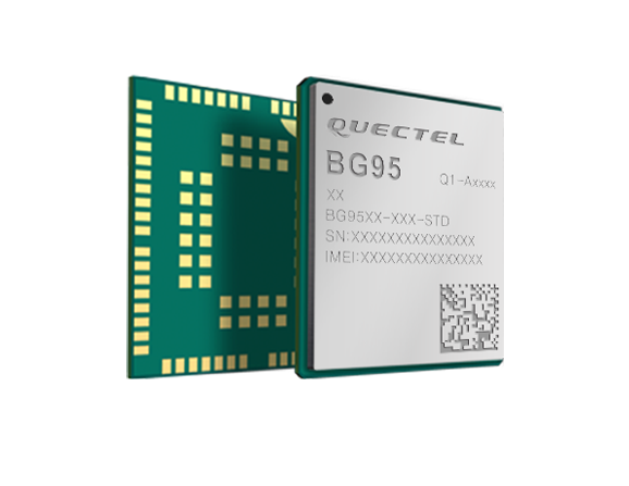
Photo: Quectel
Quectel Wireless Solutions’ LPWA module BG95 is being integrated with Microsoft’s Azure Device software development kit (SDK). The BG95 cellular module is based on the Qualcomm 9205 LTE modem. The integration will provide direct and secure connections to the Azure IoT Hub and provide full support for Azure device management. Customers can connect their BG95 devices to the Microsoft Azure cloud where they can build, manage and deploy internet of things (IoT) solutions at scale, significantly accelerating time to market. The BG95 module is a highly integrated variant supporting integrated GNSS, Cat M1, Cat NB2 and EGPRS (also called edge). The module complies with 3GPP Release 14 and delivers improved capabilities in power consumption, data rates and hardware-based security.
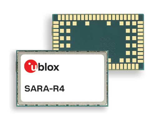
The SARA-R422 product series of LTE-M/NB-IoT and EGPRS cellular modules now include GNSS variants for internet of things (IoT) data, devices and ecosystems. The SARA-R422M8S module is pre-integrated with the u-blox M8 GNSS receiver and a separate GNSS antenna interface. This provides highly reliable, accurate positioning data simultaneously with LTE communications. The module also supports hybrid positioning strategies, in which positioning data provided by satellite constellations is enhanced with data from the u-blox CellLocate service, ensuring that location data is always available everywhere. The SARA-R4 series is designed for a wide range of mission-critical IoT solutions such as connected healthcare, industrial monitoring, point of sale and vending terminals, tracking and telematics devices, as well as smart lighting solutions and building automation.
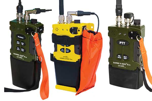
The new line of Sarbe search and rescue beacons. (Photo: Orolia)
Orolia has improved its Sarbe Evo search-and-rescue (SAR) beacon range line to deliver upgraded operational capabilities. The line offers new operational improvements to meet revised Cospas-Sarsat requirements in operating lifetime, location accuracy, voice signal management, integrated protocols, testability and maintenance. Also a focus of the upgrade was more robust and frequent GPS/GNSS position acquisition with the GPS, Galileo and GLONASS satellite constellations.
ADVA’s GNSS assurance solution could help companies dependent on satellite-based timing. (Photo: Business Wire)
ADVA’s GNSS assurance solution helps companies dependent on satellite-based timing. The centralized GNSS monitoring and assurance tool uses artificial intelligence and machine learning for comprehensive predictive maintenance. The customer-owned tool enables users to collect and analyze huge amounts of information from across the network to remotely identify issues and protect networks from GNSS vulnerabilities, including jamming and spoofing attacks. It also helps to identify GNSS obstruction issues, detect blind/poor spots that appear over time, and enable optimal antenna positioning. Built into ADVA’s Ensemble Controller network management suite with Sync Director, the solution enables customers to detect potential problems in advance and maintain the highest quality of network synchronization. It complements the limited distributed approach to GNSS assurance with a centralized global system, providing a boost to critical infrastructure now dependent on satellite-based timing.
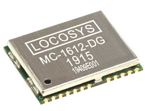
The Locosys MC-1612-DG is a single-band multi-system with an ARM-based processor that supports GPS, GLONASS, Galileo, QZSS and SBAS. The embedded micro-electro-mechanical systems (MEMS) sensor is equipped with dead-reckoning software and provides six-axis accelerometer and gyroscope data. The extended Kalman filter algorithm combines GNSS and MEMS sensor data with a weighting function that relies on GNSS signal quality. In adverse GNSS conditions such as urban canyons, tunnels or parking garages, the dead-reckoning features boost accuracy with the software filling the gaps. It supports three-dimensional dead-reckoning and standard NMEA output, and has Flash memory, TCXO, RTC crystal, LNA and SAW filter.
The automotive-grade solid-state RS-LiDAR-M1 family has the performance advantages of traditional mechanical lidar, while meeting requirements for mass-produced vehicles. The RS-LiDAR-M1Smart is embedded with an artificial intelligence perception algorithm that transforms conventional 3D lidar sensors into a full data analysis and comprehension system, outputting semantic-level structured environment information in real time for autonomous vehicle decision making. The RS-LiDAR-M1Smart outputs two redundant channels of data: the original point cloud and the object list. The redundacy provides vehicles with a range of sensing results — dynamic, static, inside and outside the road. Also available is the RS-LiDAR-M1Simple.
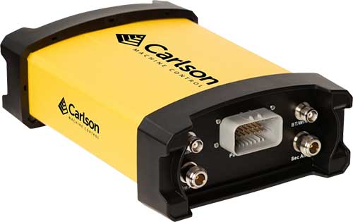
The Vsx7 multi-frequency position and heading receiver is designed specifically for machine control and can be mounted by bolts or with magnets on heavy equipment. Paired with the Carlson A45 antennas, the Vsx7 features high-precision positioning in Athena RTK, Atlas L-band and SBAS and heading accuracy of up to .01 degrees. The whole Vsx7 system is designed to operate in harsh conditions from –40° F to +158° F. The Vsx7 is primarily used in the mining and construction industries, but can be used in similar industries with companion software, Carlson Grade. Field data can be collected and viewed in real time both at the machine with either the MC8 or MC10 control box as well as in the office with Carlson Command.
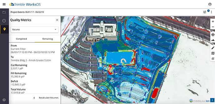
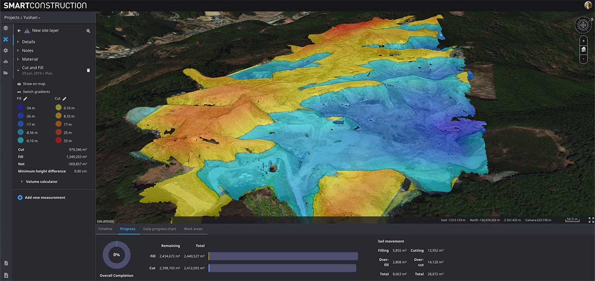
Trimble WorksOS is a new Software-as-a-Service (SaaS) operating system. The cloud-based system will integrate data from Trimble and third-party providers across the entire civil construction project lifecycle, including estimating, scheduling, designs and the field. Currently, site supervisors and project managers jump between multiple systems to keep track of daily production quantities, labor/equipment hours and equipment maintenance schedules. Works OS is designed to bring real-time visibility into jobsite progress, schedule and cost. Users will be able to log into a single application to view real-time visibility of cut, fill, volume and compaction data to maximize jobsite productivity. Site supervisors will see daily volume calculations and compaction quality metrics, and be able to monitor progress and schedules.
Komatsu’s Smart Construction dashboard includes the 3D visualization power and geospatial accuracy of Cesium, a platform to visualize, analyze and share 3D data. The dashboard enables users to monitor a construction site from anywhere in the world, see how it changes over time, and compare architectural plans with real-world data. It is compatible with data from sensors on construction machines, drone surveys, or computer-generated files like BIM/CAD models . It allows users to visualize projects in a single scene within a web browser, as well as calculate precise measurements for cut and fill, slope, contours and more.
Cesium, cesium.com
The TopoGrafi app has been updated to allow for display of 3D data in real-world models. With enhanced 3D data-processing capabilities, TopoGrafi is an end-to-end platform for capturing buried asset data and processing it for augmented reality visualizations. Designed to be used alongside apps such as Esri Collector for ArcGIS, the TopoGrafi platform uses GNSS data. It applies near-real-time conversions, transforming the recorded positions to local reference systems and aligning it with high-accuracy mapping including Ordnance Survey MasterMap. The TopoGrafi toolkit also includes functionality to snap 3D features to each other and to other spatially referenced data to create a 3D model that can then be used to create augmented reality visualizations accessible from the desktop or in the field.
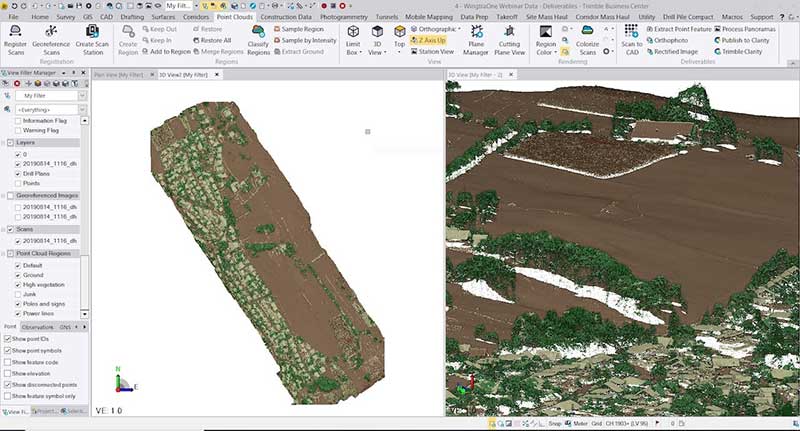
WingtraOne drone data can now be directly imported into the Trimble Business Center (TBC). The new integration combines WingtraOne high-accuracy drone data within TBC, optimizing drone mapping workflows for survey and construction projects within a single software platform. After dragging and dropping the JobXML data file, automated point cloud tools, such as classification and feature extraction, can quickly generate surface models, topographic plans and as-built deliverables. Also new: high-altitude flight capabilities, longer flight times and more intuitive battery-level readings in-flight.
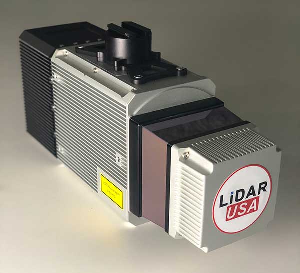
The Snoopy CL-360 lidar scanner. (Photo: Lidar USA)
The Snoopy CL-360 has been meticulously designed for integration on backpack, vehicle and UAV applications. Weighing 5 kilograms fully assembled, the Snoopy CL-360 is capable of delivering highly accurate results, up to +/-0.01 feet on paved surfaces from a vehicle. The system has a scan line rate of 250 Hz with a 500-kHz data rate, giving a uniform result along and across track. The system is easily configurable with multiple scanners (similar to internet of things applications) to avoid occlusions. A UAV deployment achieves scans with usable data as much as 60 degrees off nadir (widths of more than 1,100 feet while scanning at the 400-foot ceiling). The small beam size of 0.3 mrad allows the CL-series to reliably collect ground points (such as on or near the dirt through vegetation) while also providing better detection of fine linear features such as power lines and railroad tracks.
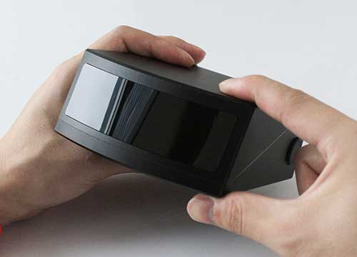
The E300 Pro receiver tracks GNSS with 700 channels and fully supports BDS-3 signals. It supports 31 frequency points, using all GNSS constellations and frequency bands. The E300 interface has a concealed design for better protection. USB type-C charging and transmitting is a two-in-one function. The magnesium-alloy body is rugged, and the battery level can be checked with a unique LED power indicator. The weight of the whole receiver is 940 grams. The E300 Pro supports satellite station differential and satellite chain life, quick connection, intelligent voice and tilt compensation. It integrates multiple sensors including GNSS, an inertial measurement unit (IMU), a magnetometer and a thermometer. With the help of a Kalman filter algorithm, the device can dynamically output position, speed and attitude information. It can measure and make real-time dynamic sampling without the need for leveling. For better radio signal quality, the E300 Pro integrates GNSS, Bluetooth, Wi-Fi, 4G main and auxiliary antennas on the top of the receiver to ensure the best reception in all directions. An RF connector improves connection reliability while reducing loss of gain.
The Nova MS60 MultiStation combines upgraded, fast 3D laser-scanning capabilities, GNSS connectivity and digital imaging with a high-end total station. It features a fast laser-scanning speed of up to 30,000 points per second, optimized scan area definitions, adapted scan managements, and an improved scanning path for zenith scans. Professionals can perform point-cloud analysis in the field. Scan data is combined with traditionally measured points from GNSS receivers to graphically show locations the same day it is collected.
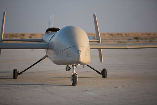
CP Aeronautics, a new division of CP Technologies, has launched integrated turn-key solutions based on unmanned aerial systems (UAS) platforms, payloads, data links, ground control stations (GCS) and communications for defense and civil applications. The systems offer operationally proven solutions for intelligence, surveillance and reconnaissance (ISR) systems requirements. Its broad product portfolio has demonstrated excellent performance and operability in demanding environments, the company stated in a press release. Backed by continuous research and development, the systems are built on three decades of technological and operational experience. Systems include Orbiter 2 Small UAS, Orbiter 3 Small Tactical UAS, Orbiter 4 Small Tactical UAS (pictured), Aerostar Tactical UAS, Dominator XP (medium-altitude long-endurance) and Pegasus 120 (vertical takeoff and landing).
A new flight control system (FCS) fits and leverages multi-mission, multi-domain UAV platforms. Using the FCS, the new Saker-1B Medium Altitude Long Endurance (MALE) UAV performs with fully autonomous online and offline operation, from takeoff to landing. Testing included more than 500 hours of day and night test missions under various weather conditions, including extremes of dust and heat. A total of 1,000 hours of take-off and landing test missions were successfully performed, with long-endurance flights lasting up to 19 hours. The Saker-1B is equipped with a satellite communication data link for beyond-visual-line-of-sight (BVLOS) operation. The FCS provides sustainability to jamming attacks and advanced data security.
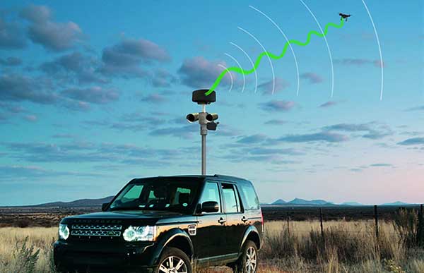
VigilAir is an RF-based system of deployed sensors able to accurately detect, geolocate and track commercial drones and their operators in different environments, including dense urban environments. VigilAir provides extremely sensitive detection and highly accurate geolocation and tracking over very large areas, with virtually zero false-alarms. Being a passive, receive-only system, VigilAir can easily be installed and operated without regulatory or legal limitations. The VigilAir version 2.0 C-UAS (counter unmanned aerial system) is certified by the United Kingdom Center for the Protection of National Infrastructure (CPNI) under the CPNI’s Counter Unmanned Aerial Systems Detect, Track and Identify (DTI) testing and evaluation standard. VigilAir generates a comprehensive drone situational awareness which enables users to proactively and intelligently match correct mitigation actions with actual drone threats, on time and with minimal collateral effects.
Xpeller Rapid — the mobile version of the counter UAV solution Xpeller — uses a combination of radar, electro-optical sensors, rangefinders and jammers to protect against threats posed by over-the-counter drones. Xpeller Rapid is either integrated into a vehicle (mast solution) or comes in transport boxes and can be easily set up on tripods. Based on the Xpeller toolkit, the components follow the detect, identify, control and act workflow, defeating hostile drones at ranges up to several kilometers. The system can locate and classify even small hobby drones at a range of several kilometers. High-resolution cameras make it possible to decide whether there is a serious threat so that it can be countered with appropriate countermeasures.
In the second part of our receiver feature, top receiver manufacturers discuss what’s on the horizon for GNSS receivers: recent and upcoming innovations, combating spoofing and jamming, fusing GNSS with other sensors, and the impact of increasing accuracy both for professional surveyors and consumers.
In January, we featured responses from NovAtel, Trimble, Unicore, Topcon, Hemisphere GNSS, CNC Navigation and Septentrio to questions about their recent and upcoming innovations in the design and manufacturing of GNSS receivers. We continue in this issue with responses to the same questions from Javad GNSS, Swift Navigation, Eos Positioning Systems, Tersus GNSS, TeleOrbit, Allystar Technology and NTLab.
All GNSS receiver manufacturers agree that spoofing and intentional and unintentional jamming are serious challenges. Their approaches to dealing with these challenges differ, however, as they rely on different combinations of technologies on both their receivers (such as monitoring cycle slips and using analog-to-digital converters, correlators and notch filters) and their antennas (such as using array antennas), as well as the new Galileo authentication service.
Photo: Tersus GNSS
Many receiver manufacturers now routinely use optical, inertial and other sensors — which continue to drop in price and increase in performance — to supplement GNSS signals where they are degraded or denied, especially in the automotive market.
Carrier phase positioning and correction services are increasingly improving the accuracy of survey stations and reducing their price. Meanwhile, submeter accuracy is spreading beyond surveying to other industries. Performance in challenging conditions also continues to improve, thanks largely to the increase in the number of GNSS constellations, available satellites and frequencies. (For a review of recent developments in antennas, see our companion article here.)
On the consumer side, the introduction of multi-frequency GNSS receiver chips, the increased use of correction services, and, in a few countries, the deployment of thousands of additional base stations will continue to increase the location accuracy of cell phones and other consumer devices, enabling new applications. However, in these devices size and cost limitations make antenna performance particularly challenging. (See Part 1 here.)
Javad GNSS
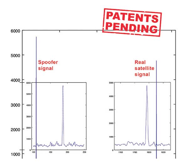
Jamming and Spoofing. “We protect you against jammers and spoofers like no one else can,” said Javad Ashjaee, founder and CEO of Javad GNSS. “We use multiple techniques to detect spoofers, the most important being the use of digital signal processing to detect more than one peak. First, with 864 channels and about 130,000 Quick Acquisition Channels in our Triumph chip, we have resources to assign more than one channel to each satellite to find all signals that are transmitted with that GNSS PRN code. If we detect more than one reasonable and consistent correlation peak for any PRN code, we know that we are being spoofed and can then identify the spoofer signals and ignore the wrong peak.”
An example of two peaks. (Chart: Javad GNSS)
Ashjaee described additional techniques:
The J-Shield filter blocks out-of-band interference.
Sixteen 255th-order FIR anti-jam digital filters protect against static in-band interference, and 16 adaptive 80th-order digital filters protect against dynamic interference.
Javad products measure the level of interference as a percentage of in-band noise above normal.
The Triumph chip has a powerful spectrum analyzer. Each spectrum shows the power and the shape of the interfering signals and jammers. This is more powerful and more efficient than using a commercial spectrum analyzer to evaluate the environment.
The chip also keeps a record of Automatic Gain Control, which is another indicator of external signals. A change in AGC can indicate interference.
Deviation of SNR from the expected value is another important indicator of interference.
“Usually there are over 100 signals available at any given time, and we need only four good signals to compute position. It is extremely unlikely that we can be spoofed without our knowledge.” Ashjaee concluded. “We will immediately recognize and take corrective actions.”
Jamming and spoofing protection is available on all Javad GNSS receivers and OEM boards. Read more about Javad GNSS’s jamming and spoofing protection in the December 2019 issue.
Sensor Fusion. “To support users in environments where GNSS RTK solutions are difficult or impossible to obtain,” Ashjaee said, “Javad GNSS has invented the J-Mate, which is a remotely controlled robotic EDM device and digital camera. GNSS RTK and optical can be seamlessly integrated using the J-Mate as the seventh RTK engine. Just set up a Triumph-3 on top of a J-Mate and a Triumph LS on top of a zebra rod, making the former pair the RTK base station and the latter pair the RTK rover.” Read more about Javad GNSS’s RTK and Optical United solution in the November 2019 issue.
Swift Navigation
Jamming and Spoofing. “Receivers have become more robust to intentional jamming by mimicking the jammers’ behavior to cancel it,” said Alex Pun, staff product manager for Swift. “Nevertheless, advanced jamming and spoofing mitigation often imply array antennas. A real evolution lies in considering these threats only in terms of the availability of the GNSS sensor, now part of a complete multi-sensor positioning engine such as Starling.”
Sensor Fusion. IMUs, visual sensors and GNSS will aid each other in different types of environments and scenarios, explained Pun. “Sensors are becoming more affordable, and their performance increases with each new generation. Sensor fusion will be the glue that will bind them to provide a precise positioning solution.”
Surveying. The combined use of carrier-phase positioning and correction services, such as Swift’s Skylark, will greatly improve accuracy and reduce the cost of survey stations, because they make their accuracy less dependent on the intrinsic performance of the receiver and the antenna, Pun said. “A global service eliminates the need for an individual base station.”
Consumer Devices. “The introduction of dual-frequency GNSS receivers from chip manufacturers will help improve positioning in cell phones and other consumer devices,” Pun said. “These chips, coupled with a widely available correction service such as Skylark, will greatly improve their performance accuracy to sub-meter levels.”
Other Challenges. Performance stability of the antenna and its characterization will become the main challenge to exploiting the new GNSS ASICs (application-specific integrated circuits) and correction services at their highest level of performance, Pun said. “A positioning engine can exploit this information to accelerate the convergence to the high-accuracy solution, and then improve its availability.”
Eos Positioning Systems
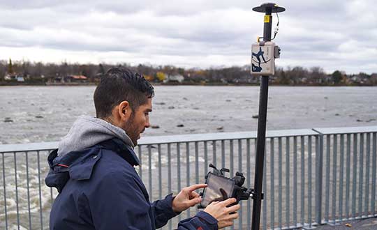
A surveyor uses the Arrow Gold receiver to map assets in Terrebonne, Quebec, Canada. (Photo: Eos Positioning)
“The past three years have seen considerable innovations and trends in the GNSS industry,” said Jean-Yves Lauture, CTO of Eos Positioning. “Receivers are becoming increasingly affordable and the adoption of higher-accuracy (submeter, centimeter) positioning by other industries, outside of conventional surveying, is growing. Considering the now four usable GNSS constellations and the aggressive launches of Galileo and BeiDou satellites, the number of available satellites and the list of frequencies they use has considerably increased.
“Although accuracy itself is not really improving, performance is — particularly in tougher conditions. It’s not uncommon for customers to use 30 to 35 satellites out of more than 40 in view using an Arrow Series GNSS receiver. The numbers are even higher in the Pacific regions, thanks to geostationary BeiDou satellites. This is, by far, more than double the number of satellites available with just GPS and GLONASS.”
Consumer Devices. “It will be challenging for smartphones and consumer devices to achieve survey-grade accuracy in the next few years. They face certain limitations. For instance, there is a cost and physical size associated with using a high-end GNSS antenna with a minimum of ground plane to achieve these levels of accuracy.
The Arrow Gold RTK GNSS receiver. (Photo: Eos Positioning)
“Also, it is unlikely that the manufacturers of consumer devices will invest in developing the advanced algorithms needed for a high level of constant accuracy and performance. In order to fit into a smartphone, consumer-grade GNSS chipset manufacturers must drop the use of many available signals and frequencies to keep both size and power consumption to a minimum.”
Allystar Technology
Photo: Allystar
Jamming and Spoofing. The GNSS chip in Allystar’s TAU1301 module supports eight adaptive notch filters to reduce the effects of GNSS jamming, explained Shi-Xian Yang, senior principal engineer in the company’s Baseband Algorithm Department. “It significantly improves the performance of GNSS tracking measurements, even in the presence of strong and fast-varying jamming signals.”
Sensor Fusion. The TAU1310 integrates a six-axis micro-electromechanical system (MEMS) gyro, which makes its affordable for the mass market, Yang said.
The Lenovo Z6. (Photo: Lenovo)
Consumer Devices. In its Z6 smartphone, Lenovo has taken advantage of the great improvement in multipath mitigation provided by the L5 signal’s higher chip rate and the output of high quality raw data via the TAU1302’s HD8040 GNSS chipset to improve the accuracy experience in the consumer market, Yang explained. Additionally, he pointed out, cell phones and other consumer devices now enable developers to access the raw sensor data from such sensors as accelerometers and barometers to input into their fusion algorithms.
Other Challenges. In the future, the TAU1310 could also support the L6 signal for PPP-RTK application.
NTLab
NTLab anti-jamming GNSS receiver. (Photo: NTLab)
Jamming and Spoofing. The problem of jamming and spoofing worries customers, according to Konstantin Yuriev, lead GNSS engineer at NTLab. The combination of anti-jam and anti-spoofing is in greater demand because the anti-jam feature alone is becoming insufficient. Yuriev cited the European Union’s new requirements for the European Railway Traffic Management System (ERTMS), which makes anti-spoofing mandatory.
The key issue today is “the solution to the problem of reducing the size and cost of anti-jam receivers, so that they become available to consumers on the civilian market. The key technology for this will be increasing the degree of integration of the component base, first creating a chipset for solving anti-jamming and anti-spoofing tasks, and then moving on to a single-chip solution. We have created a chipset and are ready to start work on the further integration into a single chip.”
Sensor Fusion. The traditional task of integrating data from a GPS antenna and a MEMS sensor has been solved, Yuriev said, with many such solutions on the market. One task is to track the antenna’s tilt. “The antenna, GNSS receiver, and MEMS sensors should be located very closely to each other — if possible, on a single small board,” Yuriev said. “Here, again, the solution is to increase the degree of integration, up to placing the baseband processor on the same chip with the digital CMOS circuitry of the MEMS sensor.” Another application of MEMS is serving as the core of an inertial navigation system (INS), providing an auxiliary subsystem for detecting the presence of spoofing. “This is more of an algorithmic task,” Yuriev said, “because traditional coupling using recursive filters is not enough. It is necessary to ensure the independence of the INS subsystem from the GNSS solution, or their intelligent mutual cross-control.”
Surveying. A major part of the cost of a survey-grade device, Yuriev pointed out, is for additional services, know-how, and other added values. There is market demand for a business model in which device price could go down while maintaining the main values for the customer. “This could be achieved if end-users tightly cooperate with hardware manufacturers, skipping third-party integrators. Alternatively, multiple third parties could compete, keeping the cost of the software low. One of the technical solutions for this is to provide software application programming interfaces (APIs) that will allow multiple third parties to offer application-level software for the same hardware. We call it the ‘open platform’ approach. One of our products implements this strategy.”
Other Challenges. Despite some skeptics, Yuriev argued, new GNSS systems have been successful. “A good example is IRNSS (NavIC), with India’s population of 1.3 billion forming a potential market. Moreover, according to our studies, good coverage is provided not only in India’s territory. We are working on creating an economically affordable solution with support for the NavIC S-band. A new chip-scale packaged RFIC (radio-frequency integrated circuit) should minimize the size, consumption, and price of NavIC-oriented modules, while maintaining all the advantages of the S-band signal in areas close to the equator. This is our solution to the problem.”
TeleOrbit
GOOSE platform. (Photo: Fraunhofer IIS)
GNSS Receiver Development Platform. The company’s GOOSE platform is a field-programmable gate array (FPGA)-based GNSS receiver, developed by Fraunhofer IIS, making it flexible in processing new or proprietary signals, according to Katrin Dietmayer, software development engineer at Fraunhofer IIS. “It comprises 60 hardware channels in real time and provides an open software interface for customer applications,” she explained.
Jamming and Spoofing. “It grants deep access to the hardware interface, down to, for example, the correlation values. Additionally, anti-jamming functions (such as notch-filter or pulse-blanker) can be added and anti-spoofing algorithms are already implemented. Thanks to the open architecture, our customers can also implement these or other algorithms.”
Sensor Fusion. Vector tracking in real time is already implemented on code base. Deep coupling with INS/IMU multi-sensor fusion — for example, with an odometer, ultra wideband or 5G — are possible and under development, Dietmayer said.
Surveying.TeleOrbit provides GNSS-RTK using RTKLIB. “The implemented Open GNSS Receiver Protocol (OGRP) is fully documented with a parsing tool using CONVBIN from RTKLIB as RINEX converter,” Dietmayer explained.
Consumer Devices. GOOSE is also used as the reference receiver in the ESA project Receiver Technologies for Future Mass Market (RT4FMM) devices. The project validates state-of-the-art dual-frequency mass-market receivers based on Broadcom BCM47755 and u-blox F9 and compares their performance against GOOSE E5AltBOC processing.
Other Challenges. GOOSE already processes the new Galileo OS-NMA (Open Service – Navigation Messages Authentication), while implementing the new Galileo High Accuracy Service (HAS) is on the roadmap. “The combination of these new features will result in a robust and reliable high-accuracy position,” Dietmayer said. “For system testing, the intermediate frequency signals can be recorded, processed and replayed with the platform.”
Tersus GNSS
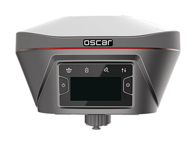
The Oscar. (Photo: Tersus GNSS)
Jamming and Spoofing. Xiaohua Wen, founder and CEO, said his company has done much research and testing on jamming and spoofing. “We already implemented a high dynamic analog-to-digital converter to overcome jamming. To mitigate spoofing, we think that internet of things (IoT) devices can leverage cloud services. Alternatively, the new Galileo authentication service may serve the same function.”
Sensor Fusion.Tersus GNSS makes an INS product, and its Oscar receiver contains an inertial measurement unit (IMU). “The sensor fusion hub is a very hot topic in the automobile industry,” Wen said. “We are quickly adapting our Oscar and INS product line for the creation of high definition maps and for indoor navigation. We think it’s still the major pain point for a crowded country such as China.”
Surveying. As has been the case in many other industries, Wen said, the widespread adoption of GNSS technology and the increase in the number of players in the field has led to a drop in prices. “Tersus’ David and Oscar models are low cost but still perform well compared with Tier 1 players for professional survey machines using our own OEM GNSS board,” he said.
Consumer Devices. The fact that a few vendors are providing dual-frequency chipsets in smartphones opens the door for consumer-grade sub-decimeter applications, Wen said. “But we think the antenna could be a big challenge for the small devices.”
Other Challenges. “Mobile carriers are building thousands of base stations,” Wen said. “For example, Softbank in Japan completed 3,300 stations this year. China Mobile just issued a bid for a phase one project for 4,400 stations. We think mobile phone innovations for the new high-accuracy application may have some impacts in the coming years. We have been actively looking at some new GIS (geographic information systems) applications based on our in-house Nuwa platform.”