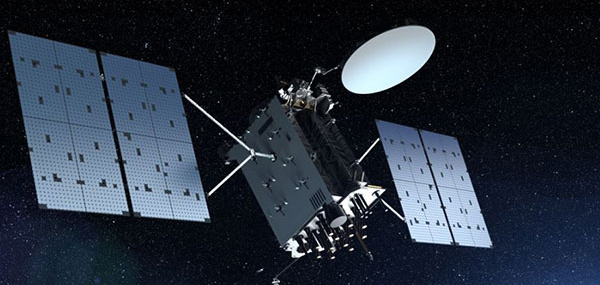
The U.S. Space Force has awarded Lockheed Martin a $514 million contract to build GPS IIIF Space Vehicles 23 and 24, bringing its total GPS IIIF commitment to 14 spacecraft.
With legacy spacecraft past their intended design life, the award marks a vital step in continued modernization of the constellation. The 14 upcoming GPS IIIF satellites will deliver advanced, reliable positioning, navigation and timing (PNT) capabilities for both military and civilian users.
IIIF capabilities include:
The Regional Military Protection capability that provides a 63-fold increase in anti-jam capabilities, allowing warfighters to access strong GPS signals in contested environments
Additional M-code-enabled satellites, allowing for secure GPS connection for warfighters
A digital navigation payload, increasing accuracy and reliability of IIIF spacecraft.
“Modernizing the constellation with highly resilient, next-generation space vehicles ensures warfighters have access to the GPS capabilities they require for their missions,” said Christina Mancinelli, vice president of global communications and navigation at Lockheed Martin. “We continue to invest in advanced technology, facilities and the people who are the driving force in the production of this spacecraft that help our military secure peace.”
Earlier this year, all Lockheed Martin-made GPS III satellites reached orbit. GPS III SV09 and SV10 each launched on accelerated timelines, bringing unprecedented levels of resiliency to the constellation.
The GPS constellation provides critical positioning, navigation and timing capabilities to key warfighter platforms made by Lockheed Martin. For example, the F‑35 uses GPS to determine its exact location, keep its systems perfectly synchronized, and share real‑time position data with other assets, enabling autonomous navigation and pinpoint strike capabilities.
Similarly, the UH-60 Black Hawk employs GPS to navigate accurately, deconflict with ground and air forces, and deliver cargo or weapons with high precision, enhancing mission safety and effectiveness.
For civilians, the GPS constellation underpins banking transactions, telecommunications networks, emergency‑response services, and everyday navigation. The new GPS IIIF satellites broadcast all civil signals — including the interoperable L1C and L5 — at greater accuracy and reliability.
Advanced design features speed and resiliency
GPS IIIF satellites are engineered for resiliency. Starting with SV13, these spacecraft are built on the evolved LM2100 Combat Bus, providing increased cyber-hardening, improved spacecraft power, propulsion and electronics. The LM2100 Combat Bus is also outfitted with additional size, weight and power to accommodate future capability insertions.
The company has already completed the core mate milestone — marking the official “birth” of a satellite — for three GPS IIIF satellites, with all other IIIF satellites in different phases of production. The company was also recently awarded a $105 million contract to continue modernization of the GPS ground segment. With these contracts, Lockheed Martin reaffirms its long-term commitment to a resilient, high-performance GPS constellation that supports billions of users worldwide.
Lockheed Martin continues to advance GPS IIIF production at its Denver area facilities, employing emerging technologies such as augmented reality and digital twins to accelerate build rates and ensure capabilities are delivered to the warfighter quickly.
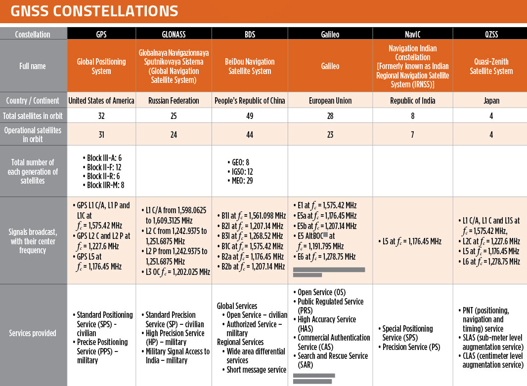
In our October 2021 issue, we celebrated the availability of four global navigation satellite system (GNSS) constellations. Below is the status (as of Feb. 23, 2023) of these four GNSS and their two regional cousins.
Many thanks to Mohamed Tamazin, Ph.D., Senior GNSS Architect for GNSS Simulation with Orolia — a Safran Electronics & Defense company, who provided or confirmed these data. While the data on GPS and Galileo are easily accessible, those for the other constellations are difficult, in some cases very difficult, to find.
USSF Lt Col Robert Wray takes command of 2SOPS. (Photo: USSF/Dennis Rogers)
The 2nd Space Operations Squadron (2 SOPS), which oversees the GPS constellation, now has a new leader. Outgoing U.S. Space Force (USSF) Lt. Col. Michael Schriever relinquished command of the unit to USSF Lt. Col. Robert Wray.
The squadron conducted a change of command ceremony at Schriever Space Force Base, Colorado, on July 6, officiated by Space Delta 8 Commander Col. Matthew Holston.
As the new commander, Wray assumes the responsibility of overseeing the daily operations of a unit whose mission is to operate the GPS constellation, which provides global navigation, time transfer, and nuclear detonation detection.
Col. Matthew Holston honors Lt. Col. Michael Schriver for his 2SOPS service. (Photo: USSF/Dennis Rogers)
Lockheed Martin, the prime contractor for GPS III/IIIF, selected L3Harris in 2018 to design and build the first two fully-digital MDUs, the heart of the satellite’s navigation payload. (Artist rendering: Lockheed Martin)
L3Harris Technologies has received contracts totaling $137 million for four navigation payload Mission Data Units (MDU) for future GPS III Follow-On (GPS IIIF) satellites.
Lockheed Martin, the prime contractor for GPS III/IIIF, selected L3Harris in 2018 to design and build the first two fully-digital MDUs, the heart of the satellite’s navigation payload. The MDU generates more powerful GPS signals and assures clock operations for GPS users, L3Harris said.
“The digital MDU is flexible enough to adapt to advances in GPS technology and future changes in mission needs,” said Ed Zoiss, president, Space and Airborne Systems, L3Harris. “The new MDU will also support a smooth transition for the U.S. Space Force’s GPS OCX ground control segment.”
The U.S. Space Force expects the first GPS IIIF satellite, which builds on GPS III adding new capabilities and technology, to be available for launch in 2026. According to L3Harris, the GPS IIIF MDU will provide improved capabilities over L3Harris’ 70-percent-digital MDU on the first ten GPS III satellites. The first four GPS III satellites have successfully launched and are now operational in the GPS constellation.
L3Harris Technologies is a global aerospace and defense technology innovator, delivering end-to-end solutions that meet customers’ mission-critical needs. The company provides advanced defense and commercial technologies across air, land, sea, space and cyber domains.
The 60th meeting of the U.S. Civil GPS Service Interface Committee was held Sept. 21-22, utilizing a virtual meeting platform. This was an opportunity for anyone in the world with access to a computer to attend these public meetings of the U.S. Civil GPS Program.
For readers who were unable to attend, a synopsis of the meeting is provided below. The full agenda and presentations are available for download from the GPS.gov website.
The meeting of the CGSIC is an annual event, free and open to the public, conducted to provide updates from U.S. GPS program officials and ensure effective information exchange between the U.S. government and civil GPS users. The two-day meeting is hosted by the U.S. Department of Transportation (DOT) and the Coast Guard Navigation Center (NAVCEN). DOT serves as the civil lead for GPS and chairs the CGSIC in this capacity. NAVCEN is assigned duties as Deputy Chair and Executive Secretariat for the CGSIC.
Subcommittees of the CGSIC for Timing, International Information, and Surveying-Mapping-Geosciences held meetings on Sept. 21, and a summary of these meetings was presented during the CGSIC plenary session conducted on September 22nd.
Major General John E. Shaw, Combined Force Space Component Commander, U.S. Space Command, and Commander, Space Operations Command, U.S. Space Force, provided the keynote for this year’s plenary session. This address was followed by comments from Colonel Curtis Hernandez, Director of National Security Space Policy on the National Space Council and briefings from a variety of other government agencies.
This year’s meeting was replete with briefings from all over the world including an explanation in the International Information Subcommittee of COVID-19 Tracking in South Korea from the Deputy Director of the Korea Ministry of the Interior and Safety.
Everett Hinkley from the U.S. National Forest Service spoke in the Surveying, Mapping and Geosciences Subcommittee showing how the National Remote Sensing Program supports a variety of business areas of the Forest Service including how they are tracking the spread of the Mountain Pine Beetle infestation in our nation’s forests.
The Timing Subcommittee provided an engaging presentation on the current and future plans of the National Institute of Standards and Technology’s new Network Time Services.
Presentations during the plenary session focused on the operational status of the GPS constellation and ground control system modernization, U.S. Space-Based PNT policy, GPS augmentation systems, U.S. engagement with other international GNSS providers, PNT resiliency efforts, as well as a variety of topics related to the status and progress of ongoing GPS programs in the U.S. government.
If you have suggestions for topics to include in upcoming CGSIC meetings, would like to present a topic, or if you found information from past meetings useful and would like to hear more, please contact us via our Navigation Center “contact us” form. Please be sure to select “Civil GPS Service Interface Committee (CGSIC)” from the pull-down menu.
From a GPS operational perspective, civilian non-aviation users can submit GPS-related inquiries or report signal interference or degradation to the U.S. Coast Guard Navigation Center online or to the 24-hour watch desk at 703-313-5900.
Civil aviation users within the United States should contact the Federal Aviation Administration for GPS user support. The GPS Operations Center at Schriever Air Force Base, Colorado, is the Department of Defense lead for operational issues and questions from military users of GPS.
Rick Hamilton CGSIC Executive Secretariat GPS Information Analysis Team Lead U.S. Coast Guard Navigation Center
As we bid farewell to the last GPS-IIA satellite and read of delays to both the launch schedule for GPS III satellites and roll-out of the OCX program, we are mindful of the need to maintain GPS as the “Gold Standard” in GNSS.
Certainly, new signals, enhanced resilience and expanded capabilities are offered by the modernized GPS playbook. Delays relative to both the BeiDou and Galileo constellations could seriously impact the position of GPS on the medals podium — maybe not in the longer term, but certainly in the coming few years.
This may have a secondary impact on the receiver market, shifting focus away from GPS to more capable signals in the near term. Once GPS has caught up, receiver manufacturers may choose to retain the technology that they developed to capitalize on BeiDou and Galileo signals, rather than developing their legacy GPS capabilities.
GPS L2C is currently “pre-operational,” transmitted by slightly more than half the existing mixed-generation satellite fleet and waiting for OCX support. As of Feb. 20, a realistic estimate for operational capability of GPS L2C is now 2023.
GPS L5 is also pre-operational, transmitted by slightly less than half of the GPS satellites and waiting for OCX support. As of Feb. 20, a realistic estimate for GPS L5 is 2027.
The forecast for GPS L1C operational capability is the late 2020s. This is intended to be the signal that offers international interoperability with the current interoperability signals offered by existing BeiDou and Galileo satellites.
Delays to the implementation of GPS L1C may mean that GPS misses the interoperability boat entirely. During the delay, new interoperability capability with even more robust signals could be devised and lofted aboard Galileo, BeiDou and GLONASS satellites. By then, other countries could also develop their own constellations, possibly regional or even global systems.
Potentially, GPS could be left behind as other nations discuss non-GPS internationally interoperable signals on yet-to-be launched satellites. This may have a profound impact on SBAS, too. Differential corrections provided by the Japanese MSAS, Russian SDCM and European EGNOS SBAS systems might evolve to support “beyond L1C” interoperability signals. Aircraft landings at world airports could mandate the use of corrections to these new signals. This might mean that U.S. receiver manufacturers could be frozen out, or will have to incorporate these new interoperable signal standards.
GPS Block III satellites along with OCX offer improved signals, capabilities and resilience, but the satellites need to be flying, OCX needs to be operational and receivers need to be in the hands of the users. Sooner rather than later is a must for Gold-Standard GPS.
Paul Crampton is a senior systems engineer at Spirent Federal Systems with more than 30 years of GPS experience.
By Peter Steigenberger, Steffen Thoelert, Oliver Montenbruck and Richard B. Langley
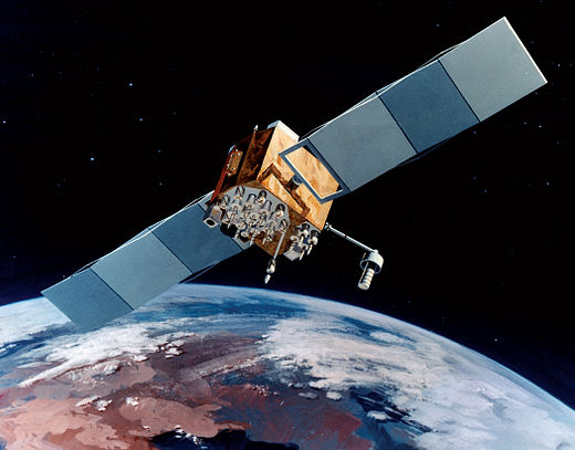
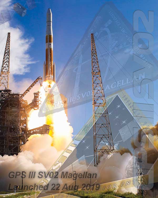
The first GPS III satellite, “Vespucci,” was launched in December 2018, started signal transmission in January 2020, and was set healthy later that month. The second GPS III satellite, nicknamed “Magellan,” was launched on Aug. 22, 2019, on a Delta IV rocket from Cape Canaveral, Florida.
Magellan, also identified by its space vehicle number (SVN) 75 (here referred to as GPS-75), started signal transmission with standard pseudorandom noise code (PRN) number 18 (here referred to as G18) on March 13. The L1 C/A, L1 P(Y), and L2 P(Y) signals were activated at 17:16:30 GPS Time (GPST), while the L1C, L2C and L5 signals followed less than two hours after Vespucci’s launch at 18:59:30 GPST. Transmission of navigation messages started at 19:00:00 GPST with GPS-75 (G18) marked as unhealthy.
PRN G18 was previously used by the 27-year-old Block IIA satellite GPS-34 that had been already removed from the active GPS constellation on Oct. 7, 2019, but continued signal transmission until March 9, 2020. GPS-75 is already being tracked by a large number of tracking stations of the International GNSS Service (IGS). Based on the data collected by these stations, the Center for Orbit Determination in Europe (CODE), headquartered in Bern, Switzerland, has been providing precise orbit and clock products for this satellite since March 14.
A comparison we performed with the CODE precise orbit products revealed initial broadcast ephemeris errors of up to 100 meters (3D) and an orbit-related signal-in-space range error (SISRE) of about 13 meters. Within four days, a SISRE (orbit component) of 24 centimeters was achieved, which closely matches the performance of the rest of the GPS constellation.
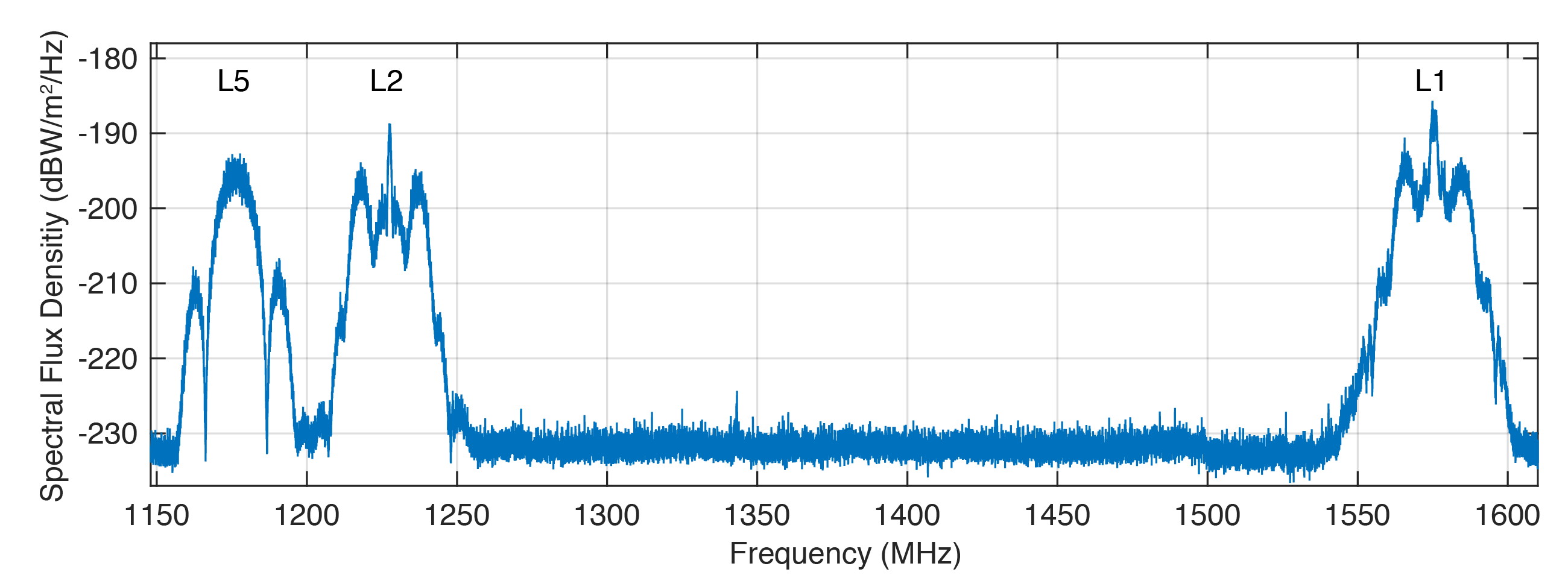
Figure 1 shows the spectral flux density of GPS-75 in the L1, L2 and L5 frequency bands obtained with the 30-meter high-gain antenna of the German Aerospace Center (DLR) located in Weilheim, Germany. The civil L1 C/A, L1C and L2C signals can be identified as sharp peaks in the center of the respective frequency bands.
FIGURE 1. Spectral flux density of GPS-75 measured with DLR’s 30-meter high-gain antenna. (Figure: Steigenberger, et al)
The prominent side lobes in the L1 and L2 bands are associated with the military M-code. The wide main lobe of the L5 signal with two smaller and sharper side lobes is caused by the superposition of two in-phase and quadrature signals with a 10-MHz binary phase-shift keying (BPSK) modulation. We found that all signals are in good shape and have a quality similar to that of the first GPS III satellite.
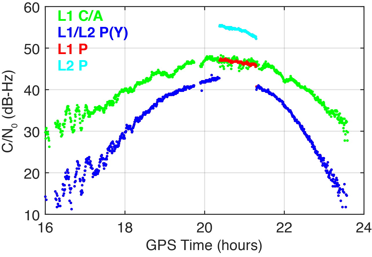
On March 16, 2020, we detected a significant change in the carrier-to-noise-density ratio of the L1 and L2 P(Y)-code signals. Figure 2 illustrates these changes for the IGS station located in Patumwan, Thailand (CUSV00THA). The L1 and L2 P-code signals are usually encrypted with the W-code to prevent spoofing (the generation of fake signals by adverse parties). The resulting encrypted signals are denoted by P(Y). Geodetic GNSS receivers are capable of tracking the P(Y) signals with a semi-codeless approach.
FIGURE 2. Carrier-to-noise-density ratio (C/N0) of the second GPS III satellite, GPS-75, tracked by the IGS station CUSV00THA in Patumwan, Thailand, on March 16, 2020. Between 20:22 and 21:18 GPST, unencrypted P-code signals were tracked. (Figure: Steigenberger, et al)
As a result, C/N0 of L1 P(Y) and L2 P(Y) are virtually identical and significantly smaller than the C/N0 of the unencrypted signals due to losses of the semi-codeless tracking technique. This can be seen in the blue-colored plot of Figure 2, where the C/N0 values of L1 P(Y) and L2 P(Y) are identical and smaller by 4.5–16 dB compared to L1 C/A depending on the elevation angle of the satellite.
However, between 20:22 and 21:18 GPST, an increase of the P-code C/N0 values was observed. The values changed by 4.5 and 12.5 dB for L1 and L2, respectively. This change is an indicator that unencrypted P-code signals were transmitted, rather than encrypted ones. This assumption can be verified by the “Anti-Spoof Flag” given as the 19th bit of the handover word (HOW) of the GPS LNAV navigation message.
Indeed, decoding of the raw navigation data from the IGS station CHOF00JPN in Chofu, Japan, showed that the Anti-Spoof Flag indicated a deactivation of anti-spoofing between 20:22:00 and 21:17:48 GPST and verified our assumption that unencrypted P-code signals were transmitted during that time period.
It has to be noted that only Javad receivers within the global multi-GNSS network of the IGS show this increase in C/N0. Other receiver types report continuous C/N0 values for the P-code signals, indicating that a semi-codeless tracking technique was continuously applied irrespective of the Anti-Spoof Flag.
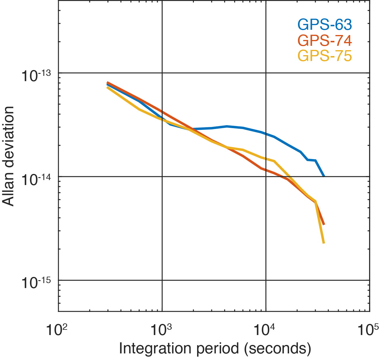
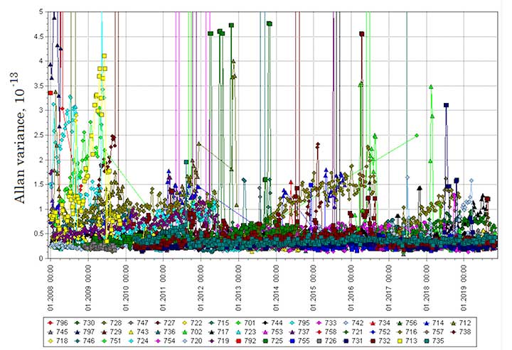
Figure 3 shows the two GPS III satellites’ Allan deviation, which measures the clock stability achieved in orbit; that is, the average frequency error over different time scales. In addition, the Block IIF satellite GPS-63 is shown, which is in the same orbital plane as GPS-75.
FIGURE 3. Allan deviation of the Block IIF satellite GPS-63 and the GPS III satellites GPS-74 and GPS-75 computed from 5-minute clock solutions produced by DLR. (Figure: Steigenberger, et al)
For integration times up to 2,000 seconds, the clock stability of GPS-75 is slightly better compared to the first GPS III satellite, GPS-74, but the situation is opposite for integration times larger than 5,000 seconds. The latter finding might be caused by the fact that GPS-75, unhealthy at the time, was tracked by a smaller number of stations compared to the healthy GPS-74.
As a consequence, the observed Allan deviation may partly be contaminated by orbit determination errors. In any case, both GPS III satellites clearly outperform the Block IIF satellite GPS-63 that suffers from thermal line bias variations visible as an increased Allan deviation starting at an integration time of about 2,000 seconds.
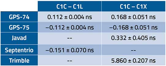
The activation of the second GPS III satellite transmitting the new civil L1C signal enables the estimation of differential code biases (DCBs) between, for example, the L1 C/A signal (Receiver Independent Exchange [RINEX] format observation code C1C) and different tracking modes of the L1C signal. Septentrio receivers track only the pilot component of the L1C signal (C1L), whereas Javad and Trimble receivers perform a combined data+pilot tracking (C1X).
DCBs are estimated from pseudorange (code) observations of a global tracking network and are corrected for ionospheric delays obtained from global ionosphere maps. The DCB estimates shown in Table 1 are based on eight days of data from 10 Javad, 21 Septentrio and 3 Trimble receivers.
TABLE 1. Differential code bias estimates in nanoseconds between L1 C/A and L1C for the GPS III satellites and average receiver DCBs. (Data: Steigenberger, et al)
As we have applied a zero-sum condition for the estimation of satellite DCBs of just two satellites, the values of GPS-74 and GPS-75 obtained from the same type of L1C observables differ only by the sign. The DCBs estimated from different L1C observables, namely C1L and C1X, differ by 56 picoseconds, corresponding to a range difference of 1.7 centimeters. The receiver DCBs are quite homogeneous for receivers from each manufacturer but differ by up to 6 nanoseconds between various manufacturers.
On April 1, 2020, GPS-75 was set healthy and joined the constellation of operational GPS satellites. The third GPS III satellite, named “Columbus,” was shipped to the Cape Canaveral launch site in February 2020. Its launch is expected no earlier than June 30, 2020, and at least two GPS III launches per year are planned for the near future.
Equipment. Measurements reported in this article were collected with JAVAD GNSS TRE_G3TH and TRE_3, Septentrio PolaRx5 and Trimble Alloy multi-GNSS, multi-frequency receivers. The spectral overview was captured with a Rohde & Schwarz EM100 digital compact receiver.
PETER STEIGENBERGER and OLIVER MONTENBRUCK are scientists at the German Space Operations Center of the German Aerospace Center (DLR). STEFFEN THOELERT is an electrical engineer at DLR’s Institute of Communications and Navigation. RICHARD B. LANGLEY is a professor at the University of New Brunswick and editor of the “Innovation” column for GPS World magazine.
Further Reading
“Optimum Semicodeless Carrier-Phase Tracking of L2” by K.T. Woo in Navigation, Vol. 47, No. 2, 2000, pp. 82-99, doi: 10.1002/j.2161-4296.2000.tb00204.x.
Interface Specification IS-GPS-200K: NAVSTAR GPS Space Segment/User Segment Interfaces by Global Positioning Systems Directorate Systems Engineering & Integration, Los Angeles Air Force Base, El Segundo, California, March 4, 2019. Available online: https://www.gps.gov/technical/icwg/IS-GPS-200K.pdf
“Apparent Clock Variations of the Block IIF-1 (SVN62) GPS Satellite“ by O. Montenbruck, U. Hugentobler, E. Dach, P. Steigenberger and A. Hauschild in GPS Solutions, Vol. 16, No.3, 2012, pp. 303-313, doi: 10.1007/s10291-011-0232-x.
“Differential Code Bias Estimation Using Multi-GNSS Observations and Global Ionosphere Maps” by O. Montenbruck, A. Hauschild and P. Steigenberger in Navigation, 2014, Vol. 61, No. 3, 2014, pp. 191-201, doi: 10.1002/navi.64
The U.S. Coast Guard has issued a Notice Advisory to Navstar Users (NANU) detailing the changes to the constellation now that the second GPS III satellite has joined.
The U.S. Space Force Second Space Operations Squadron (2 SOPS) issued an Initial Use (USABINIT) NANU for the second of the new generation of GPS-III satellites, designated SVN-75/PRN-18.
SVN-75 was launched on Aug. 22, 2019, and — having successfully undergone rigorous operational testing on orbit — has taken its place in the active GPS constellation with the slot and plane designation of D6.
Constellation changes
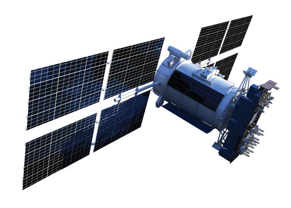
Artist’s rendering of GPS IIF satellite. (Image: U.S. Air Force )
SVN-45/PRN-21 is being re-phased from D3 to D2F replacing SVN46. Upon its arrival, SVN-46/PRN-11 will then be moved to residual status in Launch, Anomaly and Disposal Operations (LADO).
SVN-60/PRN-23 was decommissioned on March 2, eight and a half years beyond its expected service life. SVN-60 was the 12th GPS-IIR to go in to orbit, and began service on July 9, 2004.
The second GPS III satellite, nicknamed Magellan, has been designated healthy and usable.
According to a Notice of Advisory to Navstar Users (NANU) issued by the U.S. Coast Guard, the satellite has been designated usable as of April 1, 1945 ZULU.
The 2nd Space Operations Squadron (2 SOPS) accepted control of the Magellan on March 27 at the Schriever Air Force Base in Colorado.
Designated Satellite Vehicle Number 75 (SVN75) in the GPS constellation, Magellan is the second GPS III satellite to be accepted into the program, and the first to be accepted during a global pandemic.
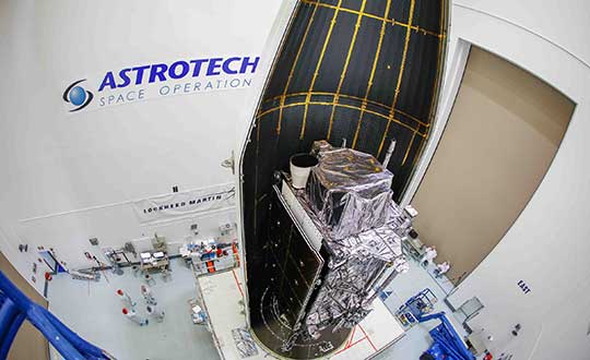
The second GPS III satellite is encapsulated before launch. (Photo: Lockheed Martin)
“We’re continuing to make major strides even while working through this pandemic, and we continue to expand our capability to further the program along,” said Lt. Col Stephen Toth, 2 SOPS commander. “This is a huge, momentous occasion for us, that we’re reaching this milestone, that our programs are being delivered, that they’re being executed and the systems are performing as expected. Ultimately, we’re all very excited that we’ve accomplished this major milestone in the program’s history, and we’re very excited for the next things to come.”
The new generation of GPS III vehicles have a 15-year design life and signals that are three times more accurate than the current generation.
“[This means users will have] better accuracy anywhere in the world, with a user’s device being able to determine their location more reliably,” said Capt. Ryan Thompson, 2nd SOPS assistant director of operations.
Additionally, the new satellites have eight times improved anti-jam capability, allowing the military warfighter to operate better in contested, degraded and operationally limited environments.
The vehicles are designed to be forward and backward compatible, which allows them to adapt to the future while remaining fully adaptable to the previous generation of vehicles.
Eight more GPS III satellites are scheduled to launch from now until 2025.
Despite any challenges that may arise, 2nd SOPS remains focused on the mission and continues to make history in space.
“As we’ve moved forward into the Space Force, we’ve taken a bigger mindset approach toward being warfighters,” Toth said. “What COVID has actually brought out of us is the full understanding of what it is to operate with a warfighter mindset. We may not be at war with an enemy per say, but we are definitely at war with the virus. My job is to ensure we continue to provide position, navigation and timing to the world. And we take that very seriously, so despite the virus, we’ll ensure that our mission continues.”
L3Harris Technologies has reached a major milestone in the U.S. Air Force’s Navigation Technology Satellite-3 (NTS-3) project — passing the preliminary design review that defines the spacecraft’s path to delivery and allows the program to move to the next phase of development.
NTS-3 is an experimental program examining ways to improve the resiliency of the military’s positioning, navigation and timing capabilities. It will also develop key technologies relevant to the Global Positioning System (GPS) constellation, with the goal of future transition to the GPS IIIF program.
In collaboration with the Air Force Research Laboratory, Space and Missile Systems Center, and United States Space Force, L3Harris is combining experimental antennas, flexible and secure signals, increased automation, and use of commercial command and control assets.
Satellite NTS-3 closeup. (Illustration: Lt. Jacob Lutz, AFRL Space Vehicles Directorate)
“The NTS-3 vanguard is an experimental, end-to-end demonstration of agile, resilient space-based positioning, navigation, and timing,” said Arlen Biersgreen, Air Force NTS-3 program manager. “It has the potential for game-changing advancements to the way the Air Force provides these critical capabilities to warfighters across the Department of Defense. The commitment demonstrated by United States Space Force to partner with AFRL and support technology transition was a key element in NTS-3 being designated as an Air Force vanguard in September 2019.”
The Space Enterprise Consortium selected L3Harris for the $84-million contract in 2018 as the prime system integrator to design, develop, integrate and test NTS-3, including ground mission applications.
“We have moved from contract award to finishing an early design review in under one year, which is an amazing accomplishment for a satellite development program that normally takes twice that amount of time,” said Ed Zoiss, President, Space and Airborne Systems, L3Harris. “We have proven we can move quickly to support the Air Force’s go-fast mission requirements.”
L3Harris has more than 40 years of experience transmitting GPS navigation signals. The company’s technology has been onboard every GPS satellite ever launched.
By Colonel John Claxton Chief, PNT Mission Integration, Air Force Space and Missile Systems Center
Image: USAF
The Global Positioning System has provided the citizens of the United States and the world the gold standard for positioning, navigation and timing (PNT) for the past 40 years. These days, GPS is seamlessly integrated into our daily lives in ways that we hardly notice. In fact, most of us expect GPS to be available in much the same way that our lights come on when we flip a switch or water comes out when we use the kitchen faucet.
None of this is easy, however, and wouldn’t happen if it wasn’t for the incredible work and communication by the members of the GPS Program Office and our terrific enterprise partners. During the next 18–24 months, the GPS enterprise will deliver the new and more powerful modernized GPS III capabilities across all segments of the system, which have been in the works and promised for the past 8–10 years. As we transition to the Space and Missile Systems Center’s (SMC) 2.0, this is a very exciting time for the GPS program. Below are some updates on our major programs.
Program Updates
GPS III. The space segment of modernized GPS has reached our goals from 2018, and then some. SV01 “Vespucci” launched on Dec. 23, 2018, heralded by celebrations across the GPS community. The GPS III team was honored to share this event with so many giants of the GPS world. We completed space vehicle (SV) 01’s On-Orbit Checkout Test in July, meeting and exceeding all performance objectives, and plan to transfer SV01 Satellite Control Authority from SMC to the 14th Air Force by the end of the year. SV01 then begins operational testing and is expected to be certified for full operations in April 2020.
SV02 “Magellan” launched on Aug. 22 aboard a United Launch Alliance Delta IV Medium rocket — the last Delta of its class — to much fanfare and celebration as well. We completed SV02 orbit raising and initial checkout in early September, and Magellan is next in line to transition to operations in 2020.
We received delivery of SV03 and SV04 from Lockheed Martin Space Systems on May 16 and Sept. 10, respectively, with launches targeted for March and July 2020.
Challenges remain — this business is hard — but the GPS III team is focused on delivering capability: improving and streamlining the largest big-satellite production line in the Department of Defense and driving our launch campaign to bring modernized capabilities, higher power performance, and the shared international L1C signal to the GPS-using world.
Figure 1. Mature Glonass-M satellites show improved cesium frequency standards performance in terms of daily stability. (Image: Roscosmos)
GPS IIIF. The GPS III Follow-On program looks to continue the success of GPS III as it moves forward in production of the first two GPS IIIF satellites. The program is well into a year-long set of detailed design reviews projected to conclude in March 2020. With Lockheed Martin as the prime contractor for both GPS satellite programs, GPS IIIF can take advantage of production-line improvements learned from GPS III to significantly reduce assembly, integration and test timelines.
Additionally, the program is helping to shape SMC’s Enterprise Commonality Initiative: an effort focused on aligning common products and processes across multiple programs to improve quality, speed up delivery and lower costs. With plans to procure 22 satellites and a delivery timeline spanning 15 years, the program has implemented a technology-insertion strategy and partnered with the Air Force Research Laboratory to ensure a timely transition of new capabilities to meet future military requirements. It is great to see the progress GPS IIIF is making in delivering its new baseline capabilities along with the steps it’s taking toward future capability insertion. The first GPS IIIF satellite launch is forecast for 2026.
GPS Next Generation Operational Control System (OCX). This past year, we used OCX Block 0, also known as the GPS III Launch and Checkout System, to launch and initialize both GPS III SV01 and SV02 and have been flying them in caretaker status until they are ready to be incorporated into the operational constellation. On OCX Block 1, all coding is complete, and the program focus is transitioning from development to system integration, test, and then transitioning the system to operations. Program investments over the past couple of years to change the program culture and modernize the factory infrastructure (often referred to DevOps) is paying off and yielding real-time metrics used to make data-driven decisions and produce higher quality code at a significantly faster rate. As a result, OCX is no longer troubled, but is now a typical large-complex software-intensive program that will experience challenges and risks. Fortunately, the right tools are in place to deliver this critical capability.
GPS Legacy Ground Sustainment. We continue to sustain our existing GPS infrastructure associated with the current Operational Control System (OCS). These sustainment efforts ensure GPS will continue to deliver the gold standard in PNT while providing the crucial on-ramp to incorporate the next generation of modernized GPS capabilities. We operationally accepted the largest OCS upgrade in GPS history. This upgrade, known as Version 7.5, virtualized the network, implemented two-factor authentication, secured connections to worldwide ground antennas, and improved encryption for mission data.
Challenged with a need to rapidly mitigate mission risk and provide enhanced cyber protection, the Red Dragon Cybersecurity Suite (RDCSS) emerged as the GPS OCS monitoring platform, providing data aggregation, analytics and multi-level Indicators of Compromise (IOC). It has evolved into an efficient and effective means to detect, investigate, and report security events and incidents.
Additionally, in August 2019 we established an RDCSS connection into the Space Enterprise Defensive Cyber Operations (DCO) solution, known as the Cyber Defense Correlation Cell for Space. This created a layered defense and a tiered DCO environment for protecting and sustaining the GPS mission.
GPS User Equipment. Over the past year our soldiers, sailors, marines and airmen continued testing and integrating mature, next-generation GPS receiver cards that provide more accurate and reliable positioning, navigation and timing. The first
Military GPS User Equipment (MGUE) receiver card was qualified this year, and the core technologies are being leveraged to develop many other types of GPS receiver cards for a wide range of DoD weapon systems. This exciting work is the culmination of nearly two decades of modernization efforts throughout the GPS enterprise.
In the near term, we are utilizing M-code-capable lead platforms — the USAF B-2 Bomber, USMC Joint Light Tactical Vehicle, USN Arleigh-Burke Class Guided Missile Destroyer and Army Stryker combat vehicle — to prove those capabilities. The second increment of MGUE now underway will focus on requirements for precision-guided munitions, a joint common modular handheld unit, as well as circuit cards and components for low size, weight and power needs. With MGUE, the DoD and services are poised to have enduring PNT solutions the warfighter can leverage for years to come.
GPS Integration Roadmaps
Integration of modernized GPS III capabilities into our major programs is a key focus of the GPS Program Office as we deliver capabilities to our warfighter and civilians users. We have continued to refine our plans and further integrate our programs and teams to ensure a seamless transition and continued high level of service.
Enterprise Road to Launch (ERTL). The Road to Launch team achieved an historic victory of firsts in December 2018. We successfully launched GPS III SV01, the first of its class. SMC partnered with SpaceX to launch SV01 aboard a Falcon 9 rocket — their first National Security Space Launch. SV01 reached orbit under the command and control of our first GPS OCX delivery, the GPS III Launch and Checkout System.
This colossal accomplishment of firsts was only possible because of the exceptionally close integration, tenacity and highly collaborative effort among all players in the community — spacecraft, payloads, launch, control, signal monitoring, acquisition, operations, test and many others. For SV01, the ERTL has now passed the torch to the Enterprise Road to Mission team — but the Road to Launch team is as busy as ever.
The mission planners, launch and orbital operations crew ensured SV02 reached medium Earth orbit with needle-threading precision in August; the team is implementing improvements based on experience as we prepare for up to three more GPS III launches in 2020; and we are already ramping up efforts to design the launch campaign for GPS IIIF.
GPS Enterprise Road to Mission (ERM). With two GPS III satellites now on orbit, it is now time to execute the Enterprise “Integration Playbook” we have developed and coordinated over the past year. The Contingency Operations (COps) modification upgrade has now been integrated into OCS on the 2 SOPS operations floor and is undergoing Developmental Testing with the GPS III SV on orbit. The program anticipates operational testing in January 2020 and Operational Acceptance in April 2020. All of our community stakeholders are ready, and with the COps modification to OCS in place, it is time to get the GPS III satellites into mission and start providing its new capabilities to our users. Over the next few months, the GPS III capabilities are expected to be operationally certified and ready for use.
GPS Enterprise Road to M-Code Mission (ERM-M-Code). With COps now in place, the next major delivery will be M-Code Early Use modification to OCS, installation of new M-code signal monitoring equipment at sites around the globe, modification of mission planning software, MGUE Increment 1 development, service lead platform integration efforts, and operationalization of space receivers. It is our continued objective to improve the ability of the Combined Space Operations Center, to respond to urgent PNT needs of the combatant commanders as they engage more sophisticated adversaries. We remain closely aligned with our peers at USSTRATCOM, AFSPC and our worldwide users across the Joint Service and allied team.
Conclusion
It has never been a more exciting time to be part of the GPS program and enterprise. Our outstanding government and contractor teams have worked so incredibly hard on integrating and communicating our programs to ensure the successful and seamless delivery of GPS III capabilities to both our warfighter and civilian users. It is a great world we live in today, and GPS makes it even better.