The U.S. Air Force GPS Wing and 50th Space Wing have begun repositioning GPS satellites in space to fly what they call the 24+3 or Expandable 24 constellation plan. The initiative will take up to 24 months to fully implement. Benefits to users will be slowly realized during that time, as the number of GPS satellites in view will increase, potentially increasing GPS receiver accuracy.
The plan significantly alters the current configuration of 30 GPS satellites on orbit. Several newer satellites now fly in tandem, side by side, with older satellites, as a hedge against their eventual failure. This policy has effectively limited constellation geometry to that of 24 satellites.
The policy change was driven at least in part by the desire to improve satellite visibility for U.S. and allied military operations in Afghanistan and Iraq, where mountainous terrain can hamper signal coverage for troops on the ground.
The first GPS space vehicle (SV) to move, SVN24, began its long journey on January 13. This satellite has the farthest to travel, and will not reach in its new slot for approximately 12 months (January 2011). The two others, SVN49 and SVN26, will affect the geometry much sooner. SVN49 started its four-month journey on January 21, destined to reach its new home in May 2010. SVN26 will stir on February 8 and should also find itself in its new slot by that time, if all goes as planned.
SVN24 will take a full 12 months because the operators must have maneuvering fuel onboard when it reaches its final orbit location for station keeping and Delta-V maneuvers; and they must conserve fuel for end-of-life in as much as 15 years to boost the satellite into a safe retired orbit.
Civil Benefits. 24+3 will especially benefit surveyors and other professionals using real-time kinematic (RTK) positioning. These users currently require six satellites in view for a very precise (centimeter accuracy) position.
In the last few years, some users that require long dwell times and experience high mask angles have been forced to use GLONASS satellites as an augmentation, which works, although GLONASS satellites have historically been less accurate than the GPS. When 24+3 is fully implemented, GLONASS augmentation may no longer be necessary for these users.
New Ground Software. The GPS Wing also trumpeted the advent of improved capabilities through a new ground-system software release. These include telemetry, tracking, and commanding for the new GPS IIF space vehicle — as yet unlaunched. On-orbit capabilities planned to arrive with the IIF Block span the new L5 navigation signal for civil users, continued and more robust security-wise deployment of the encrypted military-only code known as M-Code, on-orbit crosslink (between GPS satellites) improvements, and overall signal power increases.
In November and December 2009, the new software uploaded operational GPS IIA and IIR space vehicles with navigation data and completed normal operational functions.
Penny-Wise, Pound-Foolish U.S. Coast Guard to Pull Loran Plug
The U.S. Coast Guard announced on January 7 that the it will cease broadcasting the North American Loran-C signal on February 8.
“As a result of technological advancements during the last 20 years and the emergence of the U.S. Global Positioning System, Loran-C is no longer required by the armed forces, the transportation sector, or the nation’s security interests.”
The force, and President Barack Obama’s fiscal year 2010 budget which it cited, go against the unanimous recommendation of the Independent Assessment Team, empanelled by a previous administration and led by Bradford Parkinson, founding program director for GPS: “complete the eLoran upgrade and commit to eLoran as the national backup to GPS for 20 years.” To pay for expert advice and then ignore it is a time-honored tradition of U.S. government.
Senator Susan Collins, ranking member of the Senate Homeland Security and Governmental Affairs Committee, called the Coast Guard plan a “mistaken decision,” adding that “A lone system is problematic and ill-advised on so many levels. We need Loran as a backup to GPS.
“Pulling the plug on Loran now will likely prove penny-wise and pound foolish, because there is no other system, or constellation of systems, that offers a more robust and cost-effective backup to GPS than eLoran. It is my urgent request that the Secretary reconsider this ill-informed decision.”
Galileo Satellites Awarded to OHB
The European Commission awarded on January 7 contracts for deployment of Galileo’s initial operational capability in space. The first order of 14 satellites goes to OHB System AG of Bremen, Germany (as indicated, but not confirmed, in these pages last month).
The EC bestowed a contract for system support services upon ThalesAleniaSpace of Italy, and one for launch services to Arianespace of France. Initial deployment and service provision of Europe’s satellite navigation system is now envisioned for early 2014.
Procurement contracts for ground mission infrastructure, ground control infrastructure, and operations should be awarded by mid-2010.
The OHB order carries a value of €566 million (U.S. $811 million), with delivery of the first satellite in July 2012. One satellite is expected every 1.5 months thereafter, with the last one scheduled to be delivered in March 2014.
Compass at Three
China launched a third Beidou-2 or Compass navigation satellite on January 17, destined for geostationary (GEO) orbit. A previous middle-Earth orbit (MEO) craft went up in April 2007 and a GEO in April 2009. By January, that GEO had drifted about 16 degrees from its initial slot, possibly indicating it is uncontrollable although some reports indicate the satellite is still usable.
Eventually, China plans five GEOs and 30 MEOs. The initial Compass system will provide the Asia-Pacific region with navigation, timing, and short-message communication services as early as 2015, with a plan for global coverage by 2020.
Compass will offer an open service (free positioning and timing services, positioning accuracy 10 meters, timing 10 nanoseconds), and an authorized service, with “more secure” position, velocity, timing, and communications data as well as a higher level of integrity.
The government also unveiled an official, Chinese-language-only Compass website, www.beidou.gov.cn.
Last week, the U.S. Air Force announced it is reconfiguring the GPS constellation. The Air Force is changing the constellation from a 21+3 configuration to a 24+3 configuration. The result will be more satellites in view, on average.
This is great news for the GPS surveying and GIS mapping user. In my opinion, it was the only achievable short/medium-term solution to the GPS “brownout” problem that has plagued GPS surveying and mapping users for years, and has worsened in recent months.
In short, a GPS “brownout” is a time of the day when a GPS user is unable to utilize his or her GPS receiver because there aren’t enough satellites in view to achieve the desired accuracy. GPS “brownouts” primarily affect high-precision RTK users because that technology requires that the GPS receiver is tracking at least six satellites for a reliable position. With the current GPS constellation, there are times during the day when this is not possible given the satellite configuration and local conditions (obstructions such as trees, buildings, and terrain). This problem puts a serious damper on GPS productivity.
Even though there are currently 30 operational GPS satellites, they are configured in a 24-satellite constellation. Essentially, several satellites are “paired up” so they add no value to users on the ground. They are designated as back-up satellites in case of a failure. I wrote a detailed article on this subject in October 2009 titled GPS Constellation Management: Playing Not to Lose that summarizes the problem.
The New 24+3 Configuration
Announcements from various publications and online newsgroups have different interpretations of the Air Force announcement. Some are emphasizing increased accuracy and others are citing increased coverage in Afghanistan. While both are correct, the major benefit to the surveying/mapping user community is increased worldwide satellite visibility. In other words, more GPS satellites will be in view at a given time during the day.
More satellites in view = greater RTK and mapping productivity.
The reason that increased accuracy is mentioned in the announcement is because PDOP values will be lower in general due to the increase of satellites in view…and there’s a direct correlation between accuracy and PDOP. Just how many more satellites will be in view is not clear yet. I’m working on producing some mission planning charts that will illustrate the benefits of 24+3 compared to 21+3.
The three satellites being repositioned are SVN24, SVN26, and SVN49. SVN24 and SVN26 are two of the oldest satellites (Block-IIA) in the GPS constellation. SVN24 was declared operational in August 1991. SVN26 was declared operational in July 1992. SVN49 is a newer Block II-RM that was launched last March and has never been declared operational due to an anomaly discussed here before. More on SVN49 further down.
The time to reposition each satellite is significant. SVN24, with the furthest distance to travel, began its journey last week and will take 12 months to reach its destination slot according to the Air Force. SVN49 will begin its journey on January 21, 2010, and will take four months (May 2010). SVN26 will begin its transition on February 8, 2010, and will reach its destination slot in approximately three months (May 2010), according the Air Force.
Which Users Will Benefit the Most?
After (and maybe during) the transition, RTK users will see an increase in the number of visible GPS satellites throughout the day. As I mentioned above, I’m still working on producing satellite visibility charts to better and more accurately illustrate this, so stay tuned. Of course, the benefit is going to vary depending on where you are located.
Another group who will benefit is GIS mapping users, especially those working in difficult GPS conditions such as in forestry, urban/municipal areas, and areas where there is rugged terrain. An increased number of GPS satellites in view will allow GIS mapping users to operate in areas where it may not have been possible before and perform better in areas that were difficult.
Consumer GPS users will benefit the least. Even during times of GPS “brownouts,” the pushback from consumer GPS has been minimal. Automobile navigation systems perform without a hiccup for the most part and handheld receivers behave reasonably well. The primary reason is that both of those types of receivers aren’t selective about the satellite signals they accept. Accuracy is way down the list of important design features in those receivers. That’s not the case with RTK and professional GIS mapping receivers. RTK and GIS mapping receivers require high-quality measurement data from GPS satellites.
Will RTK Users Still Need GLONASS?
Certainly, GPS-only (non-GLONASS) RTK users will see an increased benefit with the 24+3 configuration, particularly those who are operating in relatively clear-sky environments like precision agriculture. However, as we’ve seen with this technology, users will keep pushing the GNSS envelope to use it in marginal conditions where GPS 24+3 won’t be enough. GLONASS will still contribute more satellite measurements, on average, than GPS 24+3. Therefore, GLONASS will still be a desirable feature.
But, I think we may see mainstream GNSS receiver manufacturers selling the GLONASS option at a lower price (or offering it for free) as it will be required in fewer instances. Russia is continuing to launch GLONASS satellites three at a time with the most recent launch being in December 2009 and the next scheduled one being later this spring.
SVN49 – What No One Is Talking About
One of the three GPS satellites being repositioned for 24+3 is SVN49. If you’ve kept up with the GPS constellation over the past six months, no doubt you’ve read about the SVN49 problem. It was launched last March and still hasn’t been declared healthy due to an irreparable problem. There has been much debate about what to do with SVN49. You can read about it here and here and here.
Most likely, the problem that SVN49 has will not affect RTK users. In other words, if SVN49 is set healthy, RTK users will be able to utilize it like the other normally operating GPS satellites.
However, GIS mapping users won’t benefit from SVN49. The Federal Aviation Administration (FAA) has said it won’t incorporate corrections for SVN49 in WAAS. Although the U.S. Coast Guard (USCG) and Department of Transportation (DOT) haven’t commented, I doubt they will broadcast DGPS corrections for SVN49 either. For code phase post-processing, I doubt manufacturers will modify their post-processing software to accommodate the SVN49 anomaly.
So, for GIS mapping users, it’s likely going to be a 24+2 configuration instead of a 24+3 configuration.
Either way, this is good news across the board for the GPS surveying and mapping user community.
I agree with what Don Jewell wrote in his column recently, that this subject is going to be written about and discussed a lot over the next few
months as SVN26 and SVN49 are repositioned, and over the next year as SVN24 reaches its destination.
The Russian space agency Roscosmos launched a venerable Proton rocket carrying three GLONASS-M satellites into orbit on December 14. Each 3,000-pound satellite is designed to last seven years. They join a constellation numbering 19 satellites, although only 16 are healthy.
Russian politicians and satnav system managers had hoped to launch six satellites between September and December, to attain a global service level, which requires 24 satellites, eight each in three orbital planes.
However, a payload glitch found aboard one recent satellite after its launch into space forced a return to the factory of three satellites scheduled for launch in September. The three put into orbit this week will now only bolster continuing GLONASS coverage of Russian sovereign territory, which requires 18 operating spacecraft.
The next GLONASS launch is now scheduled for a February 11–20, 2010, window.
The Block 41 GLONASS-M satellites (Nos. 30, 33, and 34) have been placed in Plane 1, which currently has only four healthy satellites. According to Roscosmos, communication has been established with all of the satellites and performance is nominal.
Next Up. Nikolay Testoedov, head of the Reshetnev satellite manufacturing company, said his enterprise plans to produce 17 more GLONASS-M satellites between now and 2013.
“The preproduction flight tests of new series of GLONASS satellites, GLONASS-K, will start in 2011,” said Andrei Buravin, vice head of Russian Institute of Space Device Engineering. The preproduction flight tests of GLONASS-K will be performed together with Reshetnev company.
It is still unclear whether the next-generation of GLONASS satellites will be launched via blocks of three satellites with Proton rockets from Baikonur, or via blocks of two satellites with Soyuz rockets from Plesetsk.
RTCM Supports Loran
It may be moot by the time you read this — the U.S. Coast Guard (USCG) could unplug Loran on January 4 — but the Radio Technical Commission for Maritime Services (RTCM) wrote to Secretary of Homeland Security Janet Napolitano in support of continuing and enhancing Loran service.
The letter asserts that it cannot be accurately certified that termination of the operation of the Loran-C signal will not adversely affect the safety of maritime navigation — counter to opinion issued by the USCG Commandant. The RTCM president states that the Loran-C infrastructure is needed to complete the eLoran system to serve as a backup to the U.S. Global Positioning System (GPS).
New Technique. Researchers have developed a technique to demonstrate a low-cost backward-compatible way to exploit eLoran to make GPS more robust. The method paves a way for the average GPS user to become a GPS+eLoran user. Go to env-gpsworld-integration.kinsta.cloud/loran for the letter and other Loran stories.
Galileo Contract Award Imminent
A contract award for at least eight of the in-orbit validation satellites had been promised for the end of this year by the European Commission (EC), but as this magazine goes to press on December 16, no official announcement has surfaced.
An unconfirmed report in early December claimed that the European Commission and European Space Agency had awarded a contract for eight Galileo satellites to underdog bidder OHB Technology of Germany. However, this report was privately denied and in fact refuted by an EC representative.
The OHB-led consortium includes small-satellite specialist Surrey Satellite Technology Ltd. of Britain, which built and continues to operate the GIOVE-A satellite, Galileo’s first launch. The competing Astrium-Thales Alenia consortium built the second Galileo satellite now in orbit, GIOVE-B.
The report, published on December 4 on the Space News website, asserted that “the European Commission has selected OHB Technology of Germany to build at least eight Galileo navigation and positioning satellites for about 350 million euros ($525 million) in a decision that postpones any award to competitor Astrium Satellites pending further negotiations with Astrium.” Reporter Peter de Selding cites industry officials as his sources.
An EC representative privately denied the report, asserting “it is not true.” An industry source said “It is not confirmed, we are waiting for the decision.”
The rumor created an uproar in the German state of Bavaria, a center for that country’s aerospace industry and government-aided research. Astrium had reportedly planned to perform much of its Galileo work in that region, and the Space News story holds out the expectation that “political pressure will be applied to reverse the ruling in the coming days.” The region is already home to the Galileo Control Center at a German Aerospace Agency (DLR) site.
Block Approach. The two consortia have been negotiating their bids on the contract with the commission and its technical adviser, the European Space Agency (ESA), for 15 months. Initially, the two European Union bodies set a contract ceiling of 840 million euros to build 28 Galileo satellites; un the past few months they revised the total order to 22 satellites and asked for bids for eight, 14, and 22 satellites. Reportedly, there are price ceilings for each of the three potential order sizes — around 400 million euros for eight satellites, 650 million euros for 14 satellites, and 840 million euros for all 22.
Repeatedly postponed throughout its conceptual phase, the Galileo system now — officially, at least — hopes to achieve initial operational capability by 2014.
Whether or not the Space News report is eventually substantiated, the central European government has already signaled in multiple ways its dissatisfaction with its various member states’ aerospace industry giants, whom it holds responsible for the protracted dysfunctionality of the now-abandoned public-private partnership to build Galileo. The EC has largely wrested control of the satellite award process away from its space agency, and indicated that it intends to maintain a firm grip on the purse strings.
Application Days: Galileo Application Days are set for March 3–5, 2010, in Brussels, Belgium, with live demonstrations of cutting-edge applications developed for GNSS under the European Union’s 7th Research Framework Programme (FP7), former ESNC Competitions, the ESA Technology Transfer Programme, and national and regional initiatives. See www.application-days.eu for details.
Roughly three years ago, the U.S. military conducted the first flex-power test on the L2 GPS codeless signal. Almost immediately, the civilian GPS community expressed concern that future changes to the L2P(Y) signal power levels might cause a signal phase shift; such a phase shift would be incompatible with equipment using the P(Y) signals in a codeless/semicodeless fashion for extremely accurate positioning applications.
Civilian users were naturally upset because they had invested millions of dollars in systems that might not be usable — even if the unusable periods were of a very short duration.
The National Positioning, Navigation, and Timing (PNT) Executive Committee responded by tasking the National PNT Engineering Forum (NPEF) to look at the problem. Within a few months, the NPEF announced a solution: flex power could be used in such a manner that it would not cause a phase shift. At the same time, the military reminded civilian users that the codeless use of L2P(Y), as accurate as it might be, was never intended and should not be a long-term solution.
An agreement was reached between the U.S. government and civilian users that the civilian users of this codeless/semicodeless technique would migrate from using the L2P(Y) carrier to using the new L2C signal to achieve not only the same, but better results. To codify this agreement, a Federal Register Notice was issued in 2008 identifying the terms of this agreement, which guaranteed the phase stability of the current L2P(Y) signal until 2020. This gives civilian users 12 years to figure out a migration plan and to obtain adequate use of the equipment they already have on hand.
In addition, 2020 is not a drop-dead date, but a date when the use of L2P(Y) codeless signals will no longer be guaranteed, though may well still work. Who knows what PNT advancements will take place between now and then? This could very well be a moot point by then, and in my opinion should be one now.
Problem Solved? Apparently not. A lag between the issuance of this national policy and analogous adjustments to interface specifications caused consternation within the civilian community. Misunderstandings added to this perceived impasse. Various solutions were identified to work around this looming quandary. However, given the national policy to support codeless/semicodeless use until 2020, the Air Force Space Command commitment to that policy, and the recommendations of the NPEF, these solutions seem wholly unnecessary to me.
The U.S. government has gone well beyond what is required to insure civilian codeless and semi-codeless users are accommodated.
For the foreseeable future, users will be able to employ L2P(Y) codeless/semicodeless techniques for very accurate position determination and will not have to worry about phase shifts disrupting their work.
— Don Jewell, GPS World Defense PNT Contributing Editor
Four Galileo in-orbit validation (IOV) satellites scheduled to launch next year have already missed their first pad date.The European version of Russia’s Soyuz rocket is now scheduled to carry the four IOV satellites into orbit in two launches in November 2010 and early 2011, as announced by European Space Agency (ESA) Director-General Jean-Jacques Dordain on October 9.
Both launches had been set for earlier in 2010, but ESA has encountered difficulties with the satellites, built by a consortium led by Astrium Satellites and Thales Alenia Space. Introduction of Russia’s Soyuz rocket at Europe’s Guiana Space Center in French Guiana, on the north coast of South America, has also been repeatedly delayed.
The European Union and ESA plan to select a builder for the remaining 28 satellites late this year. Final bids from 11 companies bidding for on six Galileo work packages are expected by November 11.
Experimental Satellite Moved. In July and August, Surrey Satellite Technology Ltd (SSTL) repositioned GIOVE-A, the first Galileo test satellite, to an orbit 113 kilometers above the orbit that the operational Galileo navigation satellites will occupy.
Since its December 2005 launch, GIOVE-A has achieved all of its mission objectives and remains in excellent condition well beyond its design life of two years, SSTL stated.
The test satellite secured the Galileo frequency filings with the International Telecommunication Union (ITU), collected data to characterise the medium-Earth Orbit (MEO) environment, and flight-proved technologies such as highly accurate atomic clocks.
GIOVE-A remains fully operational, and has sufficient propellant remaining for further maneuvers. A further repositioning exercise may be performed to raise the orbit higher still before GIOVE-A is finally decommissioned.
SSTL and its new owner, OHB of Germany, jointly form one of the two consortia now bidding for the development and construction of 28 satellites for the operational Galileo service.
EGNOS. The European Commission (EC) declared on October 1 the official start of operations by the European Geostationary Navigation Overlay Servic (EGNOS), with its Open Service available free of charge to businesses and consumers. EGNOS is Europe’s first contribution to satellite navigation and a precursor of Galileo, the global satellite navigation system in development.
EGNOS is a satellite-based augmentation system that improves the accuracy of satellite navigation signals over Europe. The system is composed of transponders aboard three geostationary satellites hovering high above the Eastern Atlantic and the European continent, linked to a ground network of about 40 positioning stations and four control centers, all interconnected. The EGNOS ground stations receive signals sent out by GPS satellites. Information on the accuracy and reliability of these signals is relayed to users via the geostationary satellite transponders. This allows them to determine their position to within two meters in real-time, according to EC spokespersons.
The EGNOS coverage area includes most European states and has the built-in capability to be extended to other regions, such as North Africa and European Union neighboring countries.
The commission seeks to support new applications in sectors such as agriculture (high-precision spraying of fertilizers) and transport (for example, automatic road-tolling or pay-per-use insurance schemes). EGNOS can also support much more precise personal navigation services, both for general and specific uses, such as systems to guide blind people and to improve signal reception in urban areas.
EGNOS will be certified for use in aviation and other safety-critical areas in compliance with the Single European Sky regulation. Through EGNOS a safety-of-life service is expected to be in place by mid 2010. This service will provide a valuable warning message informing the user within six seconds in case of a malfunction of the system. A commercial service is under test and will also be made available in 2010.
EGNOS operations are managed by the European Satellite Services Provider, ESSP SaS, a company based in Toulouse, France, founded by seven air navigation services providers. A contract between the EC and ESSP SaS covers management of the EGNOS operations and maintenance until the end of 2013.
The EGNOS Open Service is accessible, without service guarantee or resulting liability, to any user equipped with a GPS/SBAS compatible receiver within the EGNOS coverage area. Most receivers sold today in Europe meet that requirement. No authorization or receiver-specific certification is required.
GLONASS Signal Generates Slip
A planned late-September launch of a three new GLONASS-M satellites from the Baikonur space center was postponed due to a problem with signals emanating from a previously launched GLONASS-M satellites, now on orbit. Initially, a new launch date of October 29 was set by Roscosmos, the Russian space agency, but no word had yet come at press time regarding investigation of a problem with the signal generator aboard the orbiting satellite, detected in late August. The spacecraft was taken out of service on August 31.
GPS Wiggles: SVN49, CNAV
The GPS Wing held an extraordinary session at ION GNSS in Savannah, Georgia, September 23, frankly explaining the SVN 49 satellite’s problem and probable solutions.
SVN49, the IIR-M) + L5 civil-signal satellite, will be set healthy in the coming months and it will be useable, the GPS Wing said. Its L1 an L2 signals contain a pseudorange error that remains within specifications for compliant GPS user equipment.
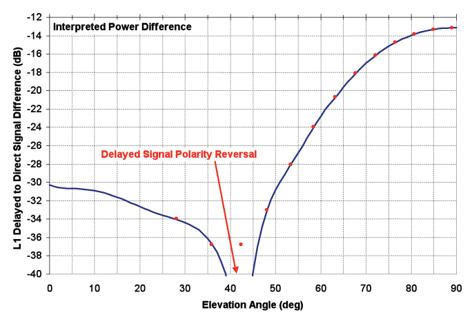
On the ground, a receiver sees from this satellite both a direct signal and a weaker reflected signal, which looks like a multipath component. According to models, if the direct and reflected L1 signals are in phase at zenith, a standard code-correlating receiver will measure a C/A-code pseudorange that is 1.62 meters too long. The error becomes smaller as the elevation angle drops, reaching zero at an elevation angle of about 42 degrees, and then rising slightly as the elevation angle drops to zero.
During audience input following the Savannah panel presentations, Javad Ashjaee of JAVAD GNSS proposed simply turning the satellite on as is and using it as an opportunity, given the “defined multipath” that it effectively transmits, to study multipath and other phenomena. JAVAD GNSS Triumph receivers have demonstrated the ability to remove almost all anomalies and satellite multipath from the SVN49 signal.
An as-yet-unconfirmed report has it that U.S. Air Force representatives and others, in an informal meeting after the session, came to a provisional agreement as to the best course. However, this has not yet worked its way through channels nor been announced.
New Message. The first test of the CNAV navigation message format to be used in the future on Block IIR-M and IIF satellites was announced at the September CGSIC meeting in Savannah, and will begin soon. A Type 0 message will be broadcast on the L2C signal by SVN49. By the end of the year, this message is to be switched on, on all IIR-M satellites. However, this initial message type will not contain useful information for end users.
Message Type 0 consists of a 12-second, 300-bit long message including the preamble, satellite pseudorandom noise (PRN) number, message type ID (=0), GPS time of week, a sequence of alternating 1s and 0s, and a cyclic redundancy check (CRC) parity block. The GPS time of week will change every 12 seconds, as will the CRC bits.
Penny Axelrad Honored
Penina Axelrad, professor of aerospace engineering sciences at the University of Colorado, received the Institute of Navigation’s 2009 Kepler Award for her “contributions in the field of satellite navigation and dedication to the education of future generations of navigation engineers.”
Axelrad has done advanced research in topics including receiver autonomous GPS integrity monitoring (RAIM), GPS bistatic radar, satellite formation flying using GPS, GPS-based orbit and satellite attitude determination, and multipath characterization, modeling, and mitigation.
She received a Ph.D. in aeronautics and astronautics from Stanford University and S.B. and S.M. degrees from the Massachusetts Institute of Technology. She has taught for 17 years at the University of Colorado.
It appears that the GPS satellite constellation has a glass ceiling, so to speak.
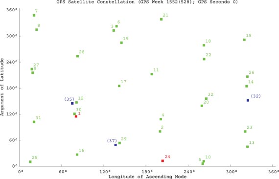
GPS was designed as a 24-satellite constellation, with four satellites in six orbital planes arranged to provide maximum observability around the globe. According to the government’s Space-Based Positioning, Navigation, and Timing website, “The U.S. government is committed to provide a minimum of 24 operational GPS satellites on orbit, 95 percent of the time. The U.S. Air Force launches additional satellites that function as active spares to accommodate periodic satellite maintenance downtime and assure the availability of at least 24 operating satellites. As of August 28, 2009, there were 35 satellites in the GPS constellation, with 30 set ‘healthy’ to users.”
Figure 1 shows the locations of the 35 satellites. Green squares indicate satellites marked healthy in the broadcast almanac. The numbers displayed are the satellites’ pseudorandom noise (PRN) codes. Red squares, with PRN codes, indicate satellites transmitting L-band signals but currently set unhealthy. Note that SVN24/PRN24, although active, is not included in almanacs. Blue squares indicate reserve satellites with space vehicle numbers (SVNs) in parentheses. Notice the bunching together of certain pairs of satellites. The constellation of 30 healthy satellites is not configured to maximize geometrical performance. Rather it is to help guarantee a minimal level of performance considering that many of the spare satellites are one component away from failure. Basically, the 30-satellite constellation is actually being flown as a 24-satellite constellation.
Figure 1. Locations of the 35 current GPS satellites: green squares denote satellites marked healthy in the broadcast almanac, satellites marked by red squares transmit L-band signals but are curerently set unhealthy, and blue squares indicate reserve satellites. Bunched pairs show satellites being flown in tandem.
But with 35 satellites in working condition, why are only 30 set healthy? Modern GPS receivers can handle all 32 PRN codes, and many studies have shown the more satellites the better as far as position accuracy and reliability are concerned. In fact, a recent Air Force Space Command article stated, “One additional GPS satellite can make a difference between getting a degraded GPS signal and getting an accurate GPS-based location, whether it is for warfighters in Baghdad or firefighters in Boston.” The current control system should, in principle, be able to handle 32 healthy satellites.
Ground Control System. But, according to the GPS Wing, the de facto limit is 31 satellites. We don’t know if this is a problem related to 2nd Space Operations Squadron (2SOPS) functions or if there is some military system or equipment platform that cannot tolerate 32 healthy satellites.
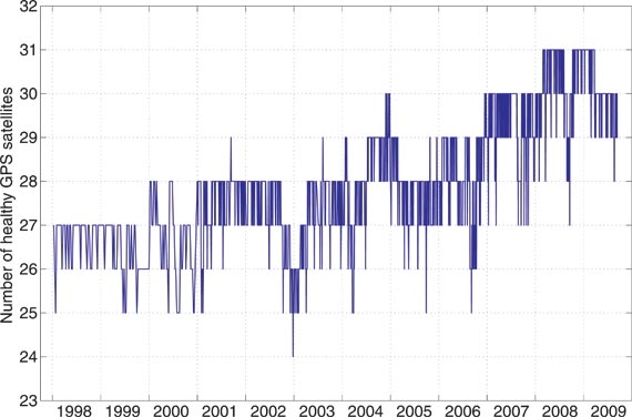
Further, if the de facto limit is 31 satellites, why have we had only a maximum of 30 satellites set healthy since early this year? After all, 2SOPS rightly crowed about having 31 satellites set healthy for the first time on February 27, 2008, when SVN23 was reintroduced into the healthy constellation as PRN32.
Figure 2, courtesy of Ted Driver at Analytical Graphics, Inc., shows the number of satellites set healthy from 1998 onward, according to the Notice Advisories to Navstar Users (NANUs) issued by 2SOPS and the almanacs broadcast by the GPS satellites. Often, a satellite is actually set unhealthy for only a portion of the day, but this plot tallies only the number of satellites healthy for a full day. As we can see, off and on through most of 2008 and into 2009, we had 31 satellites set healthy on orbit. With 31 satellites, users benefited from better availability and accuracy and were slightly better able to handle the occasional three-satellite outages due to SVN35/PRN5 and SVN25/PRN25 being set unhealthy for extended overlapping periods.
Figure 2. The number satellites set healthy since 1998 (courtesy of Analytical Graphics, Inc.)
But since March 26, 2009, when SVN35/PRN5 was decommissioned from active service, we have not seen a return to 31 healthy satellites.
Why is that?
Ground Testing. I asked this question to Col. Dave Madden, the GPS Wing commander, during a panel discussion on GNSS program updates at The Institute of Navigation’s GNSS 2009 meeting in Savannah, Georgia, in September. Apparently, the reason why 31 satellites cannot currently be set healthy simultaneously has do with ground testing of Block IIF satellites. One PRN code is needed for the test satellite on the ground. Presumably this means that testing involves tracking the constellation in space and a IIF test satellite simultaneously.
So, although everyone acknowledges that more GPS satellites are better, we have hit a 30-satellite ceiling. As IIF satellites are launched and further improvements are made to control system operations, and any incompatible old military systems are replaced or updated, perhaps we can break through this glass ceiling and have 31 or even 32 healthy GPS satellites available to users.
In sports, there is a phenomenon that sometimes occurs when a team is leading towards the end of a game. It’s called “playing not to lose”.
For example, there’s five minutes left in a basketball game and a team is leading by ten points. The leading team wants to run the clock down as much as possible and still maintain their lead. There are two basic strategies the leading team can take. One is to continue being aggressive and using the strategy that put them in a winning position to begin with. The other strategy is to try to “play it safe” until the time clock expires. The problem with the latter strategy is that the other team can sense the change in mentality and feed off of it. It’s called “playing not to lose” instead of “playing to win”. I’ve seen it happen over and over again in team sports and in business. Once an organization has achieved a level of success, they lose the edge that brought them their success.
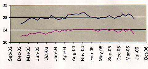
The reason you are seeing high HDOP warnings from the NAVCEN and GPS “brownouts” during the day when RTK (GPS-only) isn’t working is because the GPS satellite constellation is sub-optimal. The current design of the GPS constellation is not focused on “playing to win”, but rather “playing not to lose”.
Even the original GPS Program Manager, Dr. Brad Parkinson, has voiced his concern about GPS brownouts and discussed possible solutions. You can read one of his presentations here. In 2006, noted GNSS consultant John W. Lavrakas published a GPS World article entitled Managing the GPS Constellation for Today’s Needs discussing the disparity between the professional user community needs and GPS constellation management.
Today, there are 28 operational satellites. There were 30, but PRN08 is offline for maintenance and PRN24 was placed in active reserve after an “unusual failure”. The 31st one, PRN01/SVN49, never has been declared operational since its launch last March due to the issues discussed here before. The current GPS ground control infrastructure can only handle 30 or 31 satellites.
Given these limitations, GPS looks grim for the GPS-only RTK user, right?
Not necessarily.
The GPS constellation is optimized for 24 satellites. When there are more than 24 satellites in orbit, like there has been for many years, the extras are not positioned to benefit the users but rather to be in a position to replace satellite failures. They are sometimes referred to as “paired orbits”. Simply put, the active spares are orbiting very near other satellites that are most likely to fail. This does very little for the user community.
The current discussion is not whether to launch more satellites, but rather how to reconfigure the satellites that are in orbit. Launching more satellites is a complicated issue. It’s not just an US Air Force (the GPS stewards) technical issue, but a political one because it’s expensive (~$150M per GPS satellite launch). That leaves the Air Force with the option of adjusting the GPS constellation to benefit the user community. Doing this is not completely void of political implications I’m sure, but certainly not near the risk of launching a new satellite and certainly a better bang for your buck to the user community.
For many years in the GPS scientific community, there have been open discussions in the past of GPS constellations designed for 27 or 30 satellites. The good news is that this is an active discussion within the US Air Force today. It’s quite an important discussion because GPS-only RTK users are increasingly being shut down during the day due to the lack of GPS satellite signals and/or high PDOP. Even a constellation designed for 27 satellites would be a significant gain for GPS-only RTK users.
During my webinar a month ago, I submitted to the audience the following question:
“Do you or your crews experience GPS “brownouts” where you have to wait for the GPS constellation to change before you can continue using your GPS system?”
The following results speak for themselves:
Email me your experiences so I can continue to raise awareness of the impact the current GPS constellation is having on GPS-only RTK users. Tell me about your productivity loses, extra mission planning and other time spent dealing with the GPS “brown outs”.
I’m doing my best to make the Air Force aware of that the current constellation is causing GPS-only RTK users a significant loss in productivity. I have a feeling that the Air Force looks at the millions of consumer GPS users who are happy with their Garmins, TomToms, Magellans, etc. because those folks are able to navigate from Point A to Point B with few difficulties given the current constellation. What the Air Force doesn’t realize are that the GPS demands from the professional user community are much higher. We are the infrastructure people. Without our accurate measurements, the consumer GPS community wouldn’t enjoy the benefits they have.
RTK users need at least six satellites above 12 degrees and a PDOP below 3.0 for a robust solution. Furthermore, we have to deal with obstructions such as trees, buildings and terrain that will take out, on average, a couple of those. I think the Air Force plugs in a five degree elevation mask back in the office, looks at the sat visibility graph and says “hey, what are these guys complaining about?” The reality is that satellite signals low on the horizon don’t work as well because the data is noisier and many times rejected by the receiver. Secondly, we don’t work in parking lots where we have an unobstructed view of the horizon. We have to deal with trees, buildings and terrain that block satellite signals.
And the answer is…
At this point, there is only one solution for RTK users who need better productivity…GLONASS. As much as the Russians have taken a beating in the past for having an unreliable constellation, they hold the key for RTK productivity at this point as the GPS constellation continues to deliver “brownouts” that hamper productivity. It could turn out to be a boon for RTK receiver manufacturers. Although a few include GLONASS as a standard, most RTK receiver manufacturers charge an upgrade fee of several thousand dollars to utilize GLONASS. Even worse for some RTK users, their receiver isn’t upgradeable to utilize GLONASS so they would need to purchase a new receiver(s).
On a final note, I just spoke to a user in the field who was using a GPS/GLONASS RTK receiver. I asked him to recite to me how many GPS and GLONASS satellites he was tracking. I suppose I shouldn’t be surprised, but it did saddened me a bit. He was tracking more GLONASS satellites (6) than GPS satellites (5). Sigh…
By Richard Langleuy, with an additional note by Oliver Montenbruck
The GPS Wing and its contractors have traced the cause of pseudorange errors on L1 and L2 broadcast by the newest GPS satellite, SVN-49, to the manner in which the L5 signal demonstration payload was added to the satellite. Signal leakage between the two input ports of the antenna coupler network for the satellite’s array of 12 helical antenna elements, reflected from the L5 filter and then transmitted, creates a second signal with a delay of approximately 30 nanoseconds, and the appearance of a multipath component.
While testing an adjustment to the signal-in-space to minimize the effect of the problem on receiver navigation solutions on Earth, the GPS Wing is interested in hearing from manufacturers and the user community concerning the different impacts of SVN-49 signals on the wide range products and applications in operation, before reaching a final decision on what to do with the satellite prior to setting it healthy.
The seventh modernized GPS Block IIR satellite was launched on March 24, 2009. Called SVN-49, its sequence number in the long line of GPS satellites, or PRN01, after its pseudorandom noise code identifier, this satellite is special. In addition to the equipment required to transmit the legacy GPS C/A-code and P(Y)-code signals and the new civil L2C-code and military M-code signals on the standard L1 (1575.42 MHz) and L2 (1227.6 MHz) frequencies, SVN-49 carries an L5 demonstration payload. L5 is the new civil signal to be transmitted on 1176.45 MHz by Block IIF and succeeding generations of GPS satellites.
The demo payload was included to claim the frequency, which was allocated by the International Telecommunication Union before the August 26, 2009, deadline. The deadline had been imposed seven years earlier when the GPS Joint Program Office (the forerunner of the GPS Wing) applied for the frequency. The Block IIF program schedule had slipped a bit and as a safeguard (and one which eventually saved the day), the demo payload was developed and assigned to SVN-49.
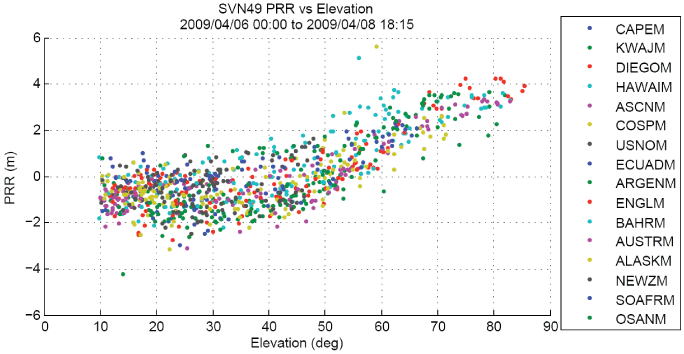
Shortly after the L1/L2 system on SVN-49 was activated on March 28, it became clear that the satellite had a small problem. The pseudorange data obtained by U.S. Air Force Space Command’s 2nd Space Operations Squadron (2 SOPS) monitor stations had larger than normal errors. Typically, the errors have a random characteristic, with a mean of zero and a peak-to-peak variation of two meters or so. But the SVN-49 ionosphere-corrected errors reached a level of about four meters and when they were plotted against the elevation angle of the satellite as viewed at each monitor station, a clear trend emerged (see Figure 1).
FIGURE 1. Ionospheric-refraction-corrected SVN4-9 pseudorange residuals from data collected at 2 SOPS monitor stations (courtesy GPS Wing).
Although larger than normal, the errors still fell within the accuracy tolerances specified for GPS signals. Nevertheless, the anomalous behavior of SVN-49’s signals was a cause of concern, and the GPS Wing and its contractors mounted efforts to find the cause.
Payload Source. They traced the source of the problem to the manner in which the L5 demo payload was added to the satellite. To understand the problem, we need to examine how the L1 and L2 signals are transmitted by a GPS satellite.
A primary and defining characteristic of GPS signals is that the received signal power should be approximately the same at any location on the Earth’s surface within view of the satellite. In other words, we should receive about the same signal power when a GPS satellite is overhead (and closer to us) as when it is low on the horizon (and further away). Any major variation in signal level seen by a receiver is typically due to the gain pattern of the receiver’s antenna.
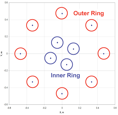
To achieve a uniform power density at the Earth’s surface, a GPS satellite uses an array of 12 helical antenna elements, with an inner ring of four elements and an outer ring of eight, fed by an antenna coupler network (see Figure 2). The L1 and L2 signals are fed into the coupler through one of its two input ports: port J1. The inner ring of elements transmits most of the L1 and L2 power from J1 with a broad pattern, while the outer ring transmits a sharper pattern but with a weaker signal and a different phase. The net effect of this arrangement is to reduce the radiated power from the inner ring as seen at high elevation angles and boost it for lower elevation angles thereby achieving an almost uniform power density.
FIGURE 2. L-band antenna element locations (courtesy GPS Wing).
The antenna coupler’s other input port, J2, is used on SVN-49 to feed the L5 signal to the antenna array after first passing through a filter and a 162-inch (411-centimeter) cable. Most of the power from J2 goes to the outer ring, with less going to the inner ring — the inverse of the power distribution from J1. This is why initial reports of L5 signal acquisition noted its high directivity with much weaker signals at low elevation angles compared with the L1 and L2 signals. But this behavior was expected.
Not expected was the effect of the L5 filter and its associated cable run on the L1 and L2 signals. It turns out that some of the L1 and L2 signal from J1 exits the J2 port, is reflected from the L5 filter, and then is transmitted from the J2 port with a delay of approximately 30 nanoseconds. With hindsight, the J1 to J2 signal leakage and reflection from the L5 filter should have been prevented.
On the ground, a receiver sees both the direct signal and the weaker reflected signal, which looks like a multipath component. The GPS Wing and its contractors have attempted to model the effect of the reflected signal on GPS receiver measurements. According to their models, if the direct and reflected L1 signals are in phase at the zenith, then a standard code-correlating receiver will measure a C/A-code pseudorange that is 1.62 meters too long. The error becomes smaller as the elevation angle drops, due to the drop in power level of the reflected signal, reaching zero at an elevation angle of about 42 degrees, corresponding to a null in the antenna pattern and then rising slightly as the elevation angle drops to zero (see Figure 3).
FIGURE 3. Model of the differences between the SVN-49 L1 delayed (multipath) and direct signals (courtesy GPS Wing).
P(Y), L2, and L2C. The same error behavior is expected for L1 P(Y)-code pseudoranges. Maximum L2 P(Y)-code pseudorange errors are modeled to be zero if the direct and reflected L2 signals are in quadrature, or to have maximum values of about plus 0.95 meters if the direct and reflected signals have the same phase, and minus 1.1 meters if they have the opposite phase. Ground tests should confirm which of the three possibilities describes the actual signals. The L2C signal is expected to behave in a similar manner to the L2 P(Y) signal.
If ionosphere-free pseudoranges are computed from the L1 and L2 pseudoranges, the maximum errors are predicted to be 4.14, 2.66, and 5.84 meters for the quadrature, in-phase, and opposite-phase L2 direct and reflected signal possibilities.
The models also predict an effect on carrier-phase measurements, but these are very much smaller: a maximum error of 6.8 millimeters on L1 and 4.8 millimeters on L2.
It is not possible to fully fix the problem. The GPS Wing and its contractors are looking at ways to minimize the effect of the problem on receiver navigation solutions. One
experiment under assessment is to adjust the broadcast navigation message ephemeris of the satellite by placing the antenna phase center about 152 meters above the actual position of the satellite, while compensating with a satellite clock offset. Such navigation message adjustments reduce the peak-to-peak variation of the error by about a half; they do not eliminate it.
Status Quo? Another possibility is to broadcast the signal as is, without attempts to compensate for the error. It would then be up to the user to determine how best to use the signals. Initial indications show that certain receivers with advanced multipath mitigation correlators can essentially filter out much of the multipath component (see Narrow Correlators Screen Error section below). Receivers with standard correlators could use the SNV-49 signals but assign a higher uncertainty to the measurements when they are combined with those from other satellites.
The GPS Wing is interested in hearing from manufacturers and the user community concerning the impact of SVN-49 signals on products and applications before coming to a final decision on what to do with the satellite before setting it healthy, and a briefing and interview process has begun to obtain that information. The decision is expect by mid-September.
— Richard B. Langley, University of New Brunswick
Narrow Correlators Screen Error
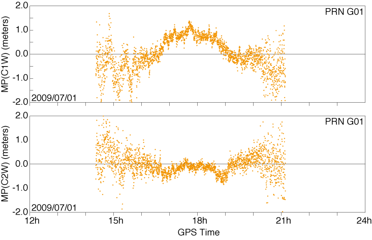
The typical variation of SVN-49 multipath errors over time is illustrated in Figure 4 for semi-codeless P(Y)-code measurements on the L1 and L2 frequency from a commercial test receiver near Munich, Germany. SVN-49 was visible for roughly 6 hours at this site and reached a peak elevation angle of 80 degrees. The errors are most pronounced on L1 where they vary between –0.5 meters near the horizon and +1 meter near the center of the pass. L2, in contrast, is notably less affected. Here, multipath errors caused by signal reflections in the satellite are well below 0.5 meters in amplitude and cannot be clearly distinguished from local multipath at the receiver site.
FIGURE 4. Typical SNV-49 multipath errors for semi-codeless P(Y)-code tracking on L1 (top) and L2 (bottom) from a conventional correlator (using JAVAD GNSS Triumph receivers.)
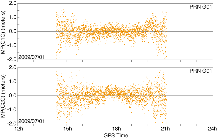
While the example shown in Figure 4 is representative for many receivers currently tracking the new GPS satellite, a few receivers are able to filter out the satellite multipath component due to the use of special multipath-mitigation techniques. While implementation details are mostly proprietary, it is commonly known that strobe or double-delta correlators can effectively counteract short-range multipath when using an extremely narrow correlator spacing. The effectiveness of such techniques is shown in Figure 5 for C/A-code and L2C-code tracking by the same test receiver. Obviously, multipath errors are well below the thermal noise in this case and the measurement errors can hardly be distinguished from those of other GPS satellites.
FIGURE 5. SVN49 multipath errors for C/A-code (top) and L2C-code (bottom) tracking using special multipath-mitigation techniques with 20-nanosecond correlator spacing (using JAVAD GNSS Triumph receivers.)
From a practical point of view, users will probably have to decide on their own whether to employ receivers with advanced multipath-mitigation capabilities, whether to apply elevation-angle-dependent measurement corrections (primarily for L1 code measurements), or whether to simply accept the moderate degradation of the SVN-49 measurements. In view of the wide variety of receivers in use and considering their varied applications, a unique solution to the SVN-49 problem is probably not feasible, and care should be taken before applying a priori “corrections” that might cause more harm than good.
(Editor’s Note: The data used to track the anomalies of SVN-49 were gathered using JAVAD GNSS Triumph receivers.)
A Preliminary Analysis of SVN49’s Demonstration Signal
By Michael Meurer, Stefan Erker, Steffen Thölert, Oliver Montenbruck, André Hauschild, and Richard B. Langley
Great excitement surrounds the activation of a new transmitter from a satellite — an occasion dubbed first light. Research groups around the globe joined the GPS Wing in monitoring and analyzing the first L5 signals from space. We describe the equipment and procedures used to capture and analyze SVN49’s signals and give an assessment of their characteristics.
INNOVATION INSIGHTS by Richard Langley
ON APRIL 10, a new type of radio signal was transmitted from space. I am referring, of course, to the L5 demonstration signal from the Block IIR-M satellite SVN49, launched on March 24. The L5 signal, the second of two new civil GPS signals, will be standard on the next generation of GPS satellites — the Block IIFs — and its frequency band was duly registered with the International Telecommunication Union (ITU) back in 2002. But satellite operators only have seven years after filing a frequency application to start transmitting signals from the designated orbit, and delays in launching the first Block IIF satellite meant that GPS could lose the allocation. The GPS Wing and its contractors determined that the best way to secure the L5 frequency was to add an L5 demonstration payload to one of the remaining modernized Block IIR satellites. And so SVN49 made history with the inaugural broadcast of L5 with just a few months to spare before the clock ran out on the ITU filing.
Great excitement always surrounds the first photons captured by a new telescope or other detectors of electromagnetic signals. Or when a transmitter is activated for the first time. Just as we do for the dawning of a new day, we call this occasion first light. Research groups around the globe joined the GPS Wing in monitoring and analyzing the first L5 signals from space, including a group of scientists and engineers from Germany and Canada. This month the group describes the equipment and procedures used to capture and analyze SVN49’s signals and gives an assessment of their characteristics.
“Innovation” features discussions about advances in GPS technology and applications as well as fundamentals of GPS positioning. The column is coordinated by Richard Langley of the Department of Geodesy and Geomatics Engineering, University of New Brunswick. To contact him, see “Contributing Editors.”
A key feature of GPS modernization is the addition of the L5 civil signal to the suite of signals transmitted by the satellites. The introduction of such a signal on a different carrier frequency than that used by the legacy L1 GPS signal was proposed in the 1995 reports by the U.S. National Research Council and the National Academy of Public Administration on the future of GPS. The reports argued that an unencrypted signal on a second frequency would offer civil users the benefit of ionospheric delay correction, wide-lane carrier-phase ambiguity resolution, improved interference rejection, and faster accuracy recovery in multipath environments.
Studies showed that it would be possible to add a civil signal on the L2 frequency without compromising the military signal. High-precision (and accuracy) civil users had been using the L2 frequency — initially designated for military use only — ever since the first GPS satellites were launched, and through clever (though suboptimum) tracking techniques even after the L2 signals were encrypted. An unencrypted signal on L2 would bring these users a more robust signal as well as affording all civil users the benefits of a second frequency. But unlike the L1 signal, the L2 signal is situated in a part of the radio spectrum not officially protected from interference by other users of the spectrum. So such a second civil signal could not be used for safety-of-life applications such as navigating aircraft.
So, in Vice President Al Gore’s statement of March 30, 1998, on the enhancement of GPS for civil users, the decision to deploy two new civil signals was announced: the civil signal on L2, now known as L2C, and a signal on a new frequency, which became known as L5. Some readers might wonder why this new signal was not designated L3 or L4. Those designations had already been assigned to signals associated with other payloads on the GPS satellites.
Although the Gore announcement proposed to introduce both of the new civil signals with the launch of the Block IIF satellites, the addition of the L2C signal to the legacy signals was deemed a relatively straightforward task and the decision was made to modify the last eight Block IIR satellites for the provision of L2C. The first modernized Block IIR satellite was launched on September 26, 2005, and seven of these satellites are now in orbit.
The frequency selected for the L5 signal, 1176.45 MHz, is in a protected aeronautical radionavigation services (ARNS) band. This frequency, as with frequencies used by all satellite operators, had to be coordinated with the International Telecommunication Union-Radiocommunication Sector (ITU-R). The ITU-R registers frequencies essentially on a first-come, first-served basis, but a user must actually transmit signals on the assigned frequency from the designated satellite orbit type within seven years from the date of filing with ITU-R. This meant that L5 signals had to be transmitted before August 26, 2009, to avoid the potential claim of the frequency by a different country. A decision was made to modify an existing Block IIR-M satellite to carry an L5 demonstration payload. The L5 demo payload, which was developed by Lockheed Martin and its subcontractors, was added to space vehicle number (SVN) 49. SVN49 was launched on March 24, 2009, the seventh modernized Block IIR satellite to be placed in orbit. Also known as PRN1, from the primary pseudorandom noise (PRN) codes assigned to the satellite, the satellite began L5 transmissions on April 10, at 11:58 UTC, and so satisfied the ITU-R filing requirement with a few months to spare.
The L5 Signal Structure
The structure of the future full L5 signal will differ significantly from the legacy L1 signal or even the modernized L2C signal. It is fully described in the Navstar GPS L5 interface document, IS-GPS-705. We present just a brief overview of the signal here.
Two-Component Signal. The full L5 signal will offer two signal components: one with and one without a superimposed navigation data message. The two signal components — in-phase (I) and quadrature (Q) — have equal power. Both will have a minimum received power of –157 dBW. Each component is modulated with a different, but synchronized, L5 PRN code. The in-phase component (the I- or data channel) is further modulated with a 100-symbol per second (sps) symbol stream carrying the navigation message data, and the quadrature component (the Q- or data-free channel, also called the pilot channel) is modulated only with a PRN code. Different, nearly orthogonal PRN codes (referred to as I5 and Q5) are used in the two components to prevent tracking biases by making each component completely independent of the other, except for the underlying carrier phase.
Another novel aspect of the L5 signal design is the use of Neuman-Hoffman (NH) synchronization codes.
Code Structure. As previously mentioned, the I5 and Q5 channels are modulated with different PRN codes. These codes differ significantly from the C/A-, P-, and L2C-codes used on L1 and L2 both in length and chipping rate.
The natural code chipping-rate frequency of 10.23 MHz as provided by the SV atomic frequency standards satisfies a number of requirements for a modernized signal within the bandwidth constraints — increased bandwidth efficiency, improved signal accuracy, immunity to waveform distortion, and improved rejection of narrowband interference. The bandwidth constraints include rejection of out-of-band interference. Accordingly, a 10.23 megachip per second (Mcps) chipping rate, 10 times that of the C/A- and L2C-codes, was adopted for the L5 PRN codes.
Improved Cross-Correlation. There is a trade off between code period and the capability to do direct acquisition. A longer code period provides better cross-correlation properties, but takes longer to search. However, one can speed up an acquisition to some extent with lower code cross-correlation levels.
The L1 C/A-code period is 1023 chips, or 1 millisecond. The desire to maintain that epoch rate of 1 kHz with the 10.23 Mcps chipping rate results in a code period of 10,230 chips. For both the I5 and Q5 ranging codes, the 1-millisecond sequences are the modulo-2 sum of two sub-sequences referred to as XA and XB with lengths of 8,190 and 8,191 chips, respectively. The same XA sequence is used for both I5 and IQ, whereas the XB sequence for I5 is different from that for Q5. The XB sequences are selectively advanced to produce different 1-millisecond-long code sequences. In this way, a large number of unique codes can be generated. Thirty-seven primary code pairs have been designated, of which 32 are reserved for use by GPS satellites (PRNs 1–32). An additional 173 pairs have been defined (PRNs 38–210). PRN sequences 38 through 63 are reserved for satellites.
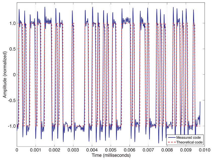
Demo Signal Verification
The L5 signal transmitted by SVN49 contains only the dataless quadrature component modulated with the PRN63 Q5 sequence. Furthermore, the transmitted L5 signal power and the satellite antenna radiation pattern are different from those expected for the L5 signals to be transmitted by the Block IIF satellites as described in the L5 interface specification.
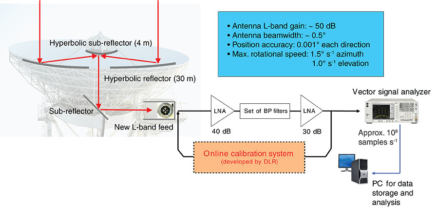
Over the past few weeks, the German Aerospace Center (Deutsches Zentrum für Luft- und Raumfahrt or DLR) has monitored SVN49 using its GNSS verification and analysis facility. The core element of the facility is a 30-meter dish antenna at Weilheim, near Munich, Germany, and is shown in FIGURE 1. The antenna, which is based on a shaped Cassegrain system, has a 30-meter-diameter parabolic reflector and a hyperbolic sub-reflector with a diameter of 4 meters. The L-Band gain of this high-gain antenna is around 50 dB, with a beam width of less than 0.5°. The position accuracy in both azimuth and elevation directions is 0.001°. The antenna’s maximum slewing speeds are 1.5° per second in azimuth and 1.0° per second in elevation angle, allowing it to easily track MEO satellites.
FIGURE 1. GNSS verification and analysis facility with 30-meter high-gain antenna at Weilheim, Germany.
In September 2005, DLR’s Institute of Communications and Navigation established an independent monitoring station for the analysis of GNSS signals using this powerful instrument. For the new challenge, the antenna was adapted to the requirements in the navigation field. A newly developed broadband circularly polarized feed and a new receiving chain including an online calibration system were installed at the antenna during preparations for the GIOVE-B in-orbit test campaign in the spring of 2008.
During this time, intensive work on the system calibration was performed using well-known signals from radio “stars” and EGNOS satellites for the antenna gain determination, and sophisticated calibration methods for the receiving system. The calibration provides an absolute measurement uncertainty significantly less than 1 dB.
Due to the distance of the antenna location from the institute at Oberpfaffenhofen (around 40 kilometers), it was necessary to perform all measurement and calibration procedures during the measurement campaigns under remote control. A software tool was developed that can control any component of the setup remotely. In addition, this tool is able to perform a completely autonomous operation of the whole system by a pre-definable sequence over any period of time. Additional details about the GNSS verification and analysis facility and the calibration techniques used can be found in the literature cited in Further Reading.
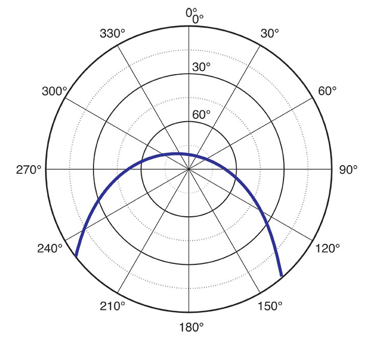
A detailed signal-in-space (SIS) analysis of the new L5 signal transmitted by SVN49 was conducted by recording several passes with the GNSS verification and analysis facility. A high elevation-angle transit of SVN49 every night allows a long observation time for each satellite pass. To ensure precise tracking of the satellite with the high-gain antenna, we used the latest two-line element sets from the U.S. Air Force Space Command.
The first signals transmitted by the satellite on the L5 frequency were captured during the pass on April 10. Compared to later measurements, the power of the L5 payload signal was measured with a lower output level on this first pass. This points to a power “fade in,” which is a common procedure in commissioning a new satellite payload. A controlled and slow heating of the payload elements avoids possible damage caused by the out-gassing of the power amplifiers, for example.
The SIS analyses that we performed using the high-gain antenna will be described for one example satellite pass recorded on April 29. During this pass, the satellite reached an elevation angle of around 80° and was visible for about seven hours (see FIGURE 2). A set of spectral snapshots as well as time sample records for the L1, L2, and L5 signals were processed and adjusted with the corresponding calibration values during a post-processing stage.
FIGURE 2. Skyplot of SVN49 pass at Weilheim, Germany, on April 29, 2009.
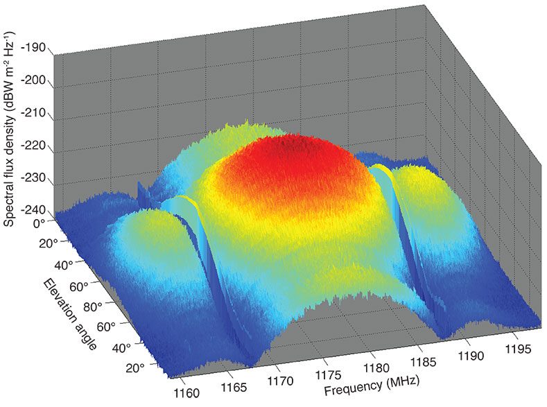
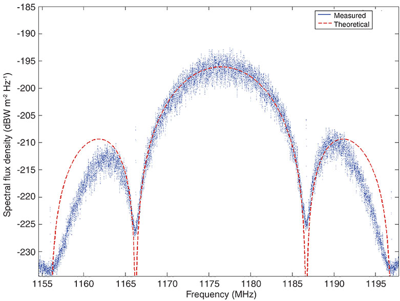
Time and Frequency. A first view of the captured spectrum snapshot in FIGURE 3 shows the L5 signal and its typical binary phase-shift-keyed (BPSK) spectral shape. The signal is significantly band limited by the used front-end filters of the satellite’s L5 payload. This ensures the required spectral separation from the adjacent L2 signal of the satellite, as the L5 signal must not interfere with the operational L2 frequency. Overlaying the theoretical spectral mask of the L5 BPSK signal, we note a slight asymmetry of the spectral shape. The two side lobes differ around 2.5 dB in their peak power level (see Figure 3). Spectral asymmetries of that kind typically result from frequency selectivity in the RF transmitter chains in satellite payloads, including the amplifiers and antennas.
FIGURE 3. L5 spectrum plot from data recorded on April 29.
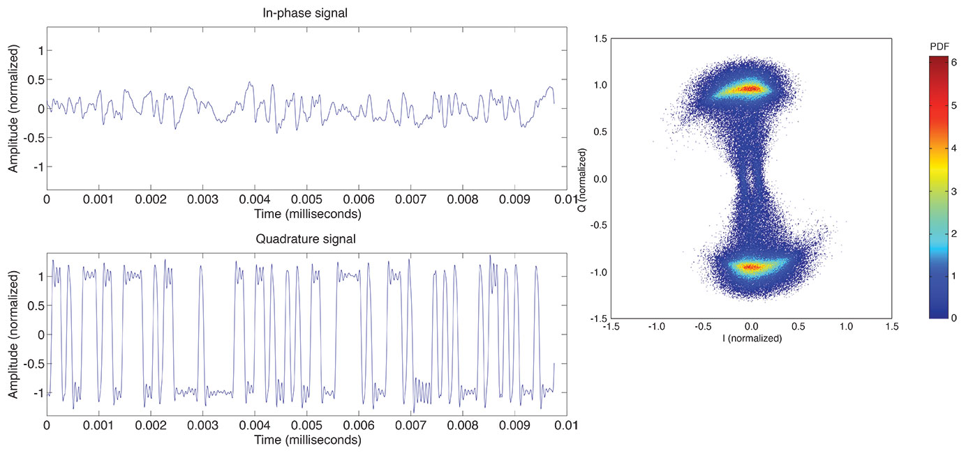
FIGURE 4 shows a temporal snapshot of the L5 signal after wiping off the Doppler frequency shift due to satellite orbital motion. Figure 4 (left) depicts a snapshot of 10 microseconds for the I and Q channels. It can be seen, that in compliance with the requirements of the L5 signal explained in the introduction of this article, the signal is a bi-level signal with a chipping rate of 10.23 Mcps. Plotting the normalized histogram of the L5 signal, one obtains the normalized I/Q probability density function (PDF) diagram of the L5 signal shown in Figure 4 (right). The constellation diagram shows a remaining deformation of the Q component after Doppler removal. Although the L5 signal transmitted by the test payload only contains the dataless Q5 component, a non-negligible contribution can be seen in the I channel. This slight distortion may stem from a nonlinear and frequency-dependent amplification of the Q baseband signal leading to crosstalk between the Q and I channels.
FIGURE 4. (left) L5 I and Q time samples; (right) L5 I/Q probability density function (PDF).
Signal Code Sequence. With the use of the high-gain antenna, it is possible to look in detail at the transmitted L5 code chips. The signal is raised high above the noise floor and, after Doppler wipe off, allows us to compare the received code sequence with the theoretical code sequence for the PRN63 Q channel. FIGURE 5 shows an example for the first 10 microseconds of the code — both for the measured L5 signal and the expected theoretical code. The analysis performed also for several full code periods shows that the demo payload’s Q5 code structure is in full compliance with the “theoretical” code described in the official signal interface document.
FIGURE 5. Comparison of measured and theoretical code sequences.
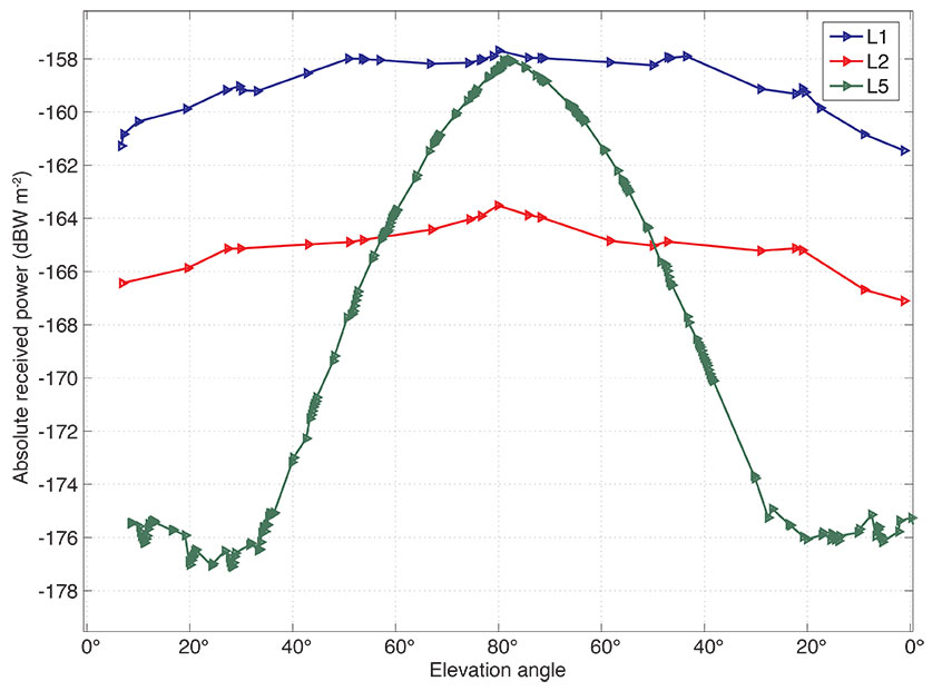
Power of Received Signals. The GNSS verification and analysis facility is fully calibrated, allowing highly accurate absolute measurements of GNSS signal power levels. We have used the system to evaluate the SVN49 signal power levels as received on the ground. FIGURE 6 shows the different signals transmitted in the L1, L2, and L5 frequency bands in terms of the received power per square meter versus elevation angle of the SV during its pass. It can be seen that there is a significant elevation-angle dependency of the L5 received power (about 18 dB between low and high elevation angles) compared to L1 and L2 (with a variation of about 3 dB). In this measurement, the combined power of the I and Q channels is plotted for the signals. So this means that the L1 and L2 signal measurements include the power of the C/A-, P(Y)-, and M-codes. Such a strong elevation-angle dependency is not typical of signals radiated by GPS satellites. However, the L5 signal is radiated using the legacy L1/L2 Block IIR-M satellite antenna, which is to the authors’ knowledge not optimized for the L5 frequency.
FIGURE 6. Absolute received power for SVN49 L1, L2, and L5 signals on April 29, 2009.
In the spectrogram plot of FIGURE 7, which was generated by plotting all recorded L5 spectra versus elevation angle, the impact of this elevation-angle dependency of the received power can be detailed for the complete frequency range. The side lobes of the BPSK signal are only clearly visible in the spectrogram at higher elevation angles.
FIGURE 7. Spectrogram for L5 signal received on April 29, 2009.
Signal Tracking
In parallel with the detailed signal validation using the high-gain antenna and vector signal analyzer, an effort has also been made to track the new GPS L5 signal using conventional correlating GNSS receivers. Given the relevance of L5/E5 signals for future aeronautical applications and the ongoing transmission of such signals from the GIOVE satellites, a growing number of commercial receiver manufacturers have announced receivers supporting this frequency band. However, due to the special nature of the SVN49 test signal (pilot only, with different PRN code designations on L1 and L5) some modifications to receiver software are required to properly track the first GPS L5 signal. In particular, the use of different PRN code designations employed for L1/L2 (PRN1) and L5 (PRN63) is clearly non-standard and requires suitably adapted receiver software, which was provided by the makers of the two receiver types we selected for our test campaign.
Receiver type N is a highly configurable test receiver for L1 and L5/E5a signals developed as part of the Galileo program. It offers a total of 16 tracking channels, which are implemented in a field-programmable gate array and can thus be flexibly adapted for tracking of civil GPS, satellite-based augmentation systems, and the GIOVE-A and -B signals in their respective frequency bands. Receiver type J, in contrast, represents the latest generation of geodetic grade multi-constellation receivers. It uses an advanced application-specific integrated circuit with 216 tracking channels supporting all types of non-military navigation signals in the L1/E1, L2, and L5/E5a bands. Both receivers have been used for some time prior to the launch of SVN49 to track GPS and GIOVE satellites from stations at the University of New Brunswick (UNB) in Canada and at DLR in Germany.
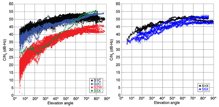
The first measurements of GPS L5 were successfully collected on April 10 with a type N receiver at UNB. While these measurements confirmed the capability to properly track SVN49 in the L5 band, they already revealed a distinct aspect of the GPS L5 test signal that potential users must be aware of. The signal is much weaker at low elevation angles than the L1 signal. Normal carrier-to-noise-density ratios (C/N0) are only achieved at elevation angles of about 60° and higher. On the other hand, the measured C/N0 near zenith may even outperform that of L1 and L2 tracking with sufficient L5 antenna gain. For illustration, FIGURE 8 compares the measured C/N0 values of GPS and GIOVE-A/B signals as obtained with receiver type J and a geodetic antenna at DLR, Oberpfaffenhofen.
FIGURE 8. Comparison of the relative signals strength (expressed as carrier-to-noise-density ratio, C/N0) for GPS (left) and GIOVE-A/B signals (right). The signals are described by their respective RINEX 3.00 data format identifiers, which reflect the type of measurement (S=signal strength), the frequency band (1=L1/E1, 2=L2, 5=L5/E5a) and the signal attribute (C=C/A or L2C, W=P(Y) semicodeless, X=pilot and data).
While not officially confirmed so far, the abnormal variation of the L5 signal strength can best be attributed to a non-standard gain pattern of the satellite transmitter antenna. Apparently, the existing Block IIR-M satellite antenna “farm” has been used to transmit the L5 signal, which results in more directivity than that of the L1 and L2 signals. This results in a weaker signal for receivers further away from the antenna boresight axis, or, equivalently, stations observing the satellite at low elevation angles. Even though the achieved C/N0 of the GPS L5 test signal is lower than that of the direct L1 C/A-code and L2 L2C-code tracking for most of a tracking arc, the signal quality still exceeds that of the semicodeless P(Y)-code tracking on L1 and L2. This makes the signal a valuable basis for experimentation in aviation applications or triple-frequency processing.
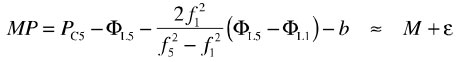
To assess the quality of the raw GPS measurements, we made use of the so-called multipath combination of pseudorange and carrier-phase measurements:
The combination is essentially the difference between the pseudorange (PC5) and carrier-phase measurement (ΦL5) on the L5 frequency, and therefore measures the sum of the pseudorange multipath (M) and noise (ε). Due to the opposite sign of ionospheric path delays on code and phase measurements, an ionospheric correction is used in the multipath combination, which requires phase measurements on a second frequency (in this case L1). The individual carrier-phase biases are, furthermore, aggregated into a common bias (b). Other than in a traditional zero-baseline test, the multipath combination neither requires a second receiver nor a second satellite transmitting the same signal in space. It is therefore best suited for studying the tracking performance of the new GPS L5 test signal.
Results for receiver types N and J obtained at DLR, Oberpfaffenhofen, are shown in FIGURE 9 for a sample, high-elevation angle tracking pass. Despite obvious differences that can be related to the specific multipath environment and code-smoothing strategies for the two receivers, a high quality is obtained in both cases. For the central three-hour interval, during which the L5 signal was received with normal signal strength, the achieved tracking accuracy clearly outperforms that of the L1 C/A-code signal for the given receivers. For further comparison, FIGURE 10 shows sample results of GIOVE-B E5a tracking with receiver type J. Again, the GPS L5 signal at medium- to high-elevation angles is fully competitive and a notable degradation is only evident when the signal strength is well below the values to be expected in the future operational system.
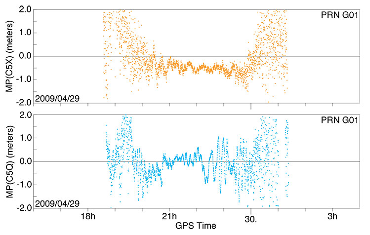
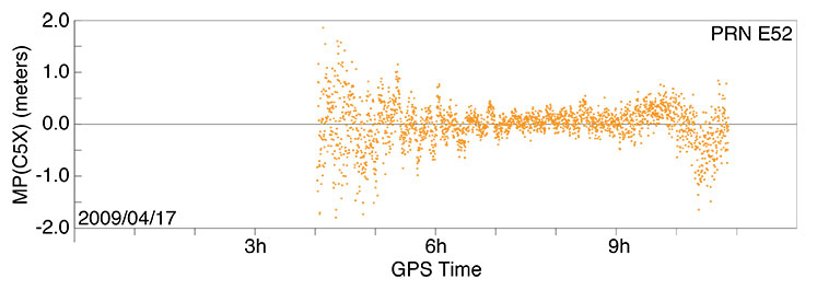
FIGURE 9. Pseudorange multipath and receiver noise of SVN49 (PRN G01) L5 tracking for a selected pass over Oberpfaffenhofen, Germany, on April 29-30, 2009. Top: receiver type J with geodetic antenna. Bottom: receiver type N with a Galileo antenna. The satellite exceeded an elevation angle of 50° between 20:30 and 23:30 with a peak elevation angle of 80° near 22:00.FIGURE 10. Pseudorange multipath and receiver noise of GIOVE-B L5 tracking for a high pass over Oberpfaffenhofen, Germany, on April 17, 2009, using receiver type J.
Legacy Signal Anomaly. While the GPS L5 signal transmission by SVN49 is clearly designated as experimental, the legacy signals (that is, the C/A- and P(Y)-code on L1 as well as L2C- and P(Y)-code on L2) were expected to achieve the same level of performance as observed on other satellites of the existing constellation. This is not the case, however, in the L1 band where both the C/A-code measurements and the semicodeless P(Y)-code pseudoranges exhibit a systematic, elevation-angle-dependent bias. This bias is not specific to any of our test receivers and can be similarly observed in heritage receivers employed at the stations of the International GNSS Service (IGS). As an example, FIGURE 11 illustrates the variation of the C/A-code error for high-elevation angle passes of SVN49 over western Canada and Germany. The bias varies between approximately -0.5 meters near the horizon and 1meter near zenith.
The cause of the bias is unclear but resides apparently in the design of the transmitter antenna or signal generation chain. It is exclusively seen on SVN49 and not on other GPS (or GIOVE) satellites, which excludes a possible problem of the receiver antenna or environment. Furthermore, data collected at UNB using the UNBJ IGS station a few days after launch clearly demonstrate that the elevation-angle-dependent L1 bias existed well before L5 signal activation and therefore might not be related to the signal generator. It is unclear to what extent the L1 signal bias can be corrected on the spacecraft and how it will affect the declaration of SVN49 as a fully healthy satellite.
FIGURE 11. Pseudorange errors of SVN49 L1 C/A code tracking for high-elevation-angle passes using a type A receiver at IGS station DRAO in Penticton, Canada (top), and a type J receiver at Oberpfaffenhofen (bottom). The satellite achieved peak elevation angles of about 70° and 80°, respectively, at the two sites.
Conclusions
Tracking and analysis of SVN49’s L5 signal using both the 30-meter dish and code-correlating receivers reveals that it possesses improved signal characteristics with respect to the legacy signals, in particular with regard to its bandwidth, and therefore will allow even more accurate and reliable positioning when the signal is deployed on the future Block IIF constellation.
Acknowledgments
We thank NovAtel and JAVAD GNSS for supplying special firmware, Sébastien Carcanague at UNB, and DLR colleagues at Weilheim for their help. The L5 signal description comes from the Innovation article by A.J. Van Dierendonck and C. Hegarty, September 2000 issue of GPS World.
Manufacturers
Receiver N is the NovAtel (www.novatel.com) EuroPak-15a. Receiver J is the JAVAD GNSS (www.javad.com) Triumph Delta-G2T. Receiver A is an Allen Osborne Associates (AOA) Benchmark ACT (www.itt.com). Space Engineering (www.space.it) Galileo Experimental Sensor Station antenna, Trimble (www.trimble.com) Zephyr Geodetic II antenna, and AOA D/MT antennas were used.
MICHAEL MEURER received a Ph.D. in electrical engineering from the University of Kaiserslautern, Germany. He is director of the Department for Navigation in the Institute for Communications and Navigation of the German Aerospace Center (DLR).
STEFAN ERKER received his diploma degree in information technology from the Technical University of Kaiserslautern and works at DLR’s Institute for Communications and Navigation.
STEFFEN THÖLERT received his diploma degree in electrical engineering from the University of Magdeburg and works at DLR.
OLIVER MONTENBRUCK works at DLR’s German Space Operations Center, Oberpfaffenhofen, where he is head of the GPS Technology and Navigation Group. He holds a Dr.rer.nat degree in physics.
ANDRÉ HAUSCHILD received his diploma degree in mechanical engineering from the Technical University of Braunschweig, Germany, and is a Ph.D. candidate at DLR’s German Space Operations Center.
Further Reading
L5 Signal Details
Interface Specification, IS-GPS-705 (IRN-705-003), Navstar GPS Space Segment/User Segment L5 Interfaces, ARINC Engineering Services, LLC, El Segundo, California, September 22, 2005.
“The New L5 Civil GPS Signal” by A.J. Van Dierendonck and C. Hegarty in GPS World, Vol. 11, No.9, September 2000, pp. 64–72.
DLR’s GNSS Verification and Analysis Facility
“GNSS Signal Verification: Spectral and Temporal Analysis of GIOVE B and BEIDOU Signals” by S. Thölert, S. Erker, M. Cuntz, M. Meurer, U. Grunert, and J. Furthner, presented at Navitec 2008, the 4th ESA Workshop on Satellite Navigation User Equipment Technologies, Noordwijk, The Netherlands, December 10–12, 2008.
“GNSS Signal Verification with a High Gain Antenna – Calibration Strategies and High Quality Signal Assessment” by S. Thölert, S. Erker, and M. Meurer in Proceedings of ITM 2009, the 2009 International Technical Meeting of The Institute of Navigation, Anaheim, California, January 26–28, 2009, pp. 289-300.
Nonlinearities in Microwave Signal Components
“Frequency-independent and Frequency Dependent Nonlinear Models of TWT Amplifiers” by A. Saleh in IEEE Transactions on Communications, Vol. 29, November 1981, pp. 1715–1720.
“Analysis of GIOVE-A L1-Signals” by S. Graf and C. Günther in Proceedings of ION GNSS 2006, the 19th International Technical Meeting of the Satellite Division of The Institute of Navigation, Fort Worth, Texas, September 26-29, 2006, pp. 1560–1566.
Commercial GNSS Receivers Used for L5 Signal Acquisition
“Triumph Technology” by J. Ashjaee presented at the 5th Allsat Open Conference, Hannover, Germany, June 19, 2008.
“A Dual-frequency L1/E5a Galileo Test Receiver” by N. Gerein, M. Olynik, M. Clayton, J. Auld, and T. Murfin in Proceedings of the European Navigation Conference – GNSS 2005, Munich, Germany, July 19-22, 2005.
The Multipath Observable
“TEQC: The Multi-Purpose Toolkit for GPS/GLONASS Data” by L.H. Estey and C.M. Meertens in GPSSolutions, Vol. 3, No. 1, 1999, pp. 42–49.
1995 Reports on the Future of GPS
The Global Positioning System: Charting the Future: Charting the Future by a panel of the National Academy of Public Administration and by a committee of the National Research Council, National Academy of Public Administration, Washington, D.C., 1995, ISBN 0-9646874-1-0.
The Global Positioning System: A Shared National Asset, Recommendations for Technical Improvements and Enhancements by the National Research Council Committee on the Future of the Global Positioning System, National Academy Press, Washington, D.C., 1995, ISBN 0-309-05283-1.
The Seminal Article on the Benefits of Three GPS Signal Frequencies
“The Promise of a Third Frequency” by R.R. Hatch in GPS World, Vol. 7, No. 5, May 1996, pp. 55–58.
Brad Parkinson, the first GPS Program Office Director, chief architect and advocate for GPS, submitted written testimony to Congress on mitigation options for possible GPS brownouts. His presentation comes in reference to the recent GAO report highlighting the risk that the GPS constellation may fall below the minimum level of 24 satellites required for full operational capability. In his opening, Parkinson states that “GAO correctly points out the possibility that the GPS constellation will be reduced to less than the current number of 30 to 32 satellites. In fact, it is possible that the constellation will be at a level of less than 24 satellites. I would like to focus on the options that would help reduce this risk.”
Parkinson chides those who may not have been paying attention over the last two years, at least. “It should be noted that the risk of brownouts has been repeatedly pointed out by the independent review teams,” he states, referencing the the Defense Science Board, the GPS Independent Review Team, and the Pos-Nav Timing Advisory Board, who have all stated all that “30 satellites is the correct number.” He points out that the European Galileo program and the Chinese Compass system have also arrived at that number.
“Although brownouts would only be ‘officially’ declared at levels below 24, anything below the current level of 30 satellites is a cause for concern. The potential economic impact if the number were below 24 may be quite serious.”
To rectify the situation, Parkinson first gives a history lesson. The first GPS satellite went from contract award to launch in 44 months. “The keys to success were a streamlined approval chain (all the way up the OSD chain), severe restrictions on any contract changes, and an integrated product team.” He believes that GPS IIIA can achieve the same — given the same playing conditions.
Spartan. He does throw in one twist not currently in the plans: “To develop a simplified GPS IIIA based design, Spartan satellite (IIIS) that would not include the extra payloads, and, once designed, could be built quickly and launched into space with two satellites on a booster. This would be done in parallel with the current program.”
Parkinson appears to advocate complete abandonment of the IIF line. “The reason is simply that the satellite design is old and relies on parts that are no longer available. In addition, the satellite, while providing the older signals, does not meet current requirements.”
He closes with a final admonition. “Above all, the senior decision making chain has to become a part of the solution. This means that they do everything in their power to help the program office achieve the needed schedule.”
The United States Government Accountability Office (GAO) issued on May 7 an alarming report on the future of GPS, characterizing ongoing modernization efforts as shaky. The agency appears to single out the IIF program as the weak link between current stability and ensured future capability, calling into doubt “whether the Air Force will be able to acquire new satellites in time to maintain current GPS service without interruption.” It asserts the very real possibility that “in 2010, as old satellites begin to fail, the overall GPS constellation will fall below the number of satellites required to provide the level of GPS service that the U.S. government commits to.”
Prepared at the request of the U.S. House of Representatives’ Subcommittee on National Security and Foreign Affairs, Committee on Oversight and Government Reform, and titled “Global Positioning System: Significant Challenges in Sustaining and Upgrading Widely Used Capabilities,” the report concludes that “it is uncertain whether the Air Force will be able to acquire new satellites in time to maintain current GPS service without interruption. If not, some military operations and some civilian users could be adversely affected.”
“In addition,” the report summary continues, “military users will experience a delay in utilizing new GPS capabilities, including improved resistance to jamming of GPS signals, because of poor synchronization of the acquisition and development of the satellites with the ground control and user equipment. Finally, there are challenges in ensuring civilian requirements for GPS can be met and that GPS is compatible with other new, potentially competing global space-based positioning, navigation, and timing systems.”
Among the report’s principal recommendations is a proposal often made in past years by a range of experts, but never implemented: the Secretary of Defense should appoint “a single authority to oversee the development of GPS, including space, ground control, and user equipment assets, to ensure these assets are synchronized and well executed, and potential disruptions are minimized.”
While the Department of Defense (DoD) concurred with this recommendation, and while quite possibly it might effectuate the streamlined decision-making and corollary processes to remedy the highlighted deficiencies, it would run counter to the integral “dual-use” principle of GPS as dedicated to both civil and military users. Such a move could thus conceivably and adversely affect the interests of civil users.
Testimony from invited GPS providers and users before a related National Security Subcommittee hearing (“GPS: Can We Avoid a Gap in Service?”), some of which is briefly encapsulated within this news story, can be downloaded.
Why GAO Did This Study. A highlights document attached to the GAO report asserts that GPS “has become essential to U.S. national security.” The GAO conducted its own analysis of Air Force satellite data, in addition to interviewing key officials and analyzing program documentation. Specifically, the agency assessed progress in:
acquiring GPS satellites
acquiring the ground control and user equipment necessary to leverage GPS satellite capabilities
coordinating efforts among federal agencies and other organizations to ensure GPS missions can be accomplished.
Gloomy Outcomes. Based on the most recent satellite reliability and launch schedule data from March of this year, the estimated long-term probability of maintaining a constellation of at least 24 operational satellites falls below 95 percent during fiscal year 2010 and remains below 95 percent until the end of fiscal year 2014, at times falling to about 80 percent. Program officials provided no evidence to suggest that the current mean life expectancy for satellites is overly conservative, the GAO stated.
The results of fewer than 24 operational satellites could include:
Intercontinental commercial air carriers may have to delay, cancel, or reroute flights.
Enhanced-911 response to emergency calls could lose accuracy, particularly operating in urban and mountainous environments — exactly where emergencies tend to be most dire and hardest to locate.
Accuracy of precision-guided munitions could decrease, forcing the military to use larger munitions or use more munitions on the same target to achieve the same level of mission success, and increasing the risks of collateral damage. The urgent desire to decrease or eliminate collateral damage to civilians in or near conflict zones has often been cited by the founders of GPS as one of their key motivations in envisioning the program.
Both standard positioning service and precise positioning service could suffer, impacting large numbers of civil users, both professional (for example, surveyors) and casual (users of location-based services via cell phones) in moderately mountainous areas, in large cities, and under forest foliage.
Block IIF at the Crux. Cristina T. Chaplain of the GAO presented the report to Congress, stating, “In recent years, the Air Force has struggled to successfully build GPS satellites within cost and schedule goals; it encountered significant technical problems that still threaten its delivery schedule; and it struggled with a different contractor. As a result, the current IIF satellite program has overrun its original cost estimate by about $870 million and the launch of its first satellite has been delayed to November 2009 — almost three years late.”
The GAO reports cites specific problems with the IIF satellites contracted to Boeing. During the first phase of thermal vacuum testing in 2008, one of the test payload’s transmitters failed; consequently, the program suspended testing in August 2008 to identify the causes and take corrective action. Other hang-ups include maintaining the proper propellant fuel-line temperature, delaying final integration testing, and re-design of the satellite’s reaction wheels, used for pointing accuracy, because of on-orbit failures on similar reaction wheels on other satellite programs. Overall, about $10 million additional have accrued to program, according to the GAO.
“Further, while the Air Force is structuring the new GPS IIIA program to prevent mistakes made on the IIF program, the Air Force is aiming to deploy the next generation of GPS satellites three years faster than the IIF satellites. GAO’s analysis found that this schedule is optimistic, given the program’s late start, past trends in space acquisitions, and challenges facing the new contractor.
“Of particular concern is leadership for GPS acquisition, as GAO and other studies have found the lack of a single point of authority for space programs and frequent turnover in program managers have hampered requirements setting, funding stability, and resource allocation.
“If the Air Force does not meet its schedule goals for development of GPS IIIA satellites, there will be an increased likelihood that in 2010, as old satellites begin to fail, the overall GPS constellation will fall below the number of satellites required to provide the level of GPS service that the U.S. government commits to. Such a gap in capability could have wide-ranging impacts on all GPS users, though there are measures the Air Force and others can take to plan for and minimize these impacts.
“In addition to risks facing the acquisition of new GPS satellites, the Air Force has not been fully successful in synchronizing the acquisition and development of the next generation of GPS satellites with the ground control and user equipment, thereby delaying the ability of military users to fully utilize new GPS satellite capabilities.
“Diffuse leadership has been a contributing factor, given that there is no single authority responsible for synchronizing all procurements and fielding related to GPS, and funding has been diverted from ground programs to pay for problems in the space segment. DoD and others involved in ensuring GPS can serve communities beyond the military have taken prudent steps to manage requirements and coordinate among the many organizations involved with GPS. However, GAO identified challenges in the areas of ensuring civilian requirements can be met and ensuring GPS compatibility with other new, potentially competing global space-based positioning, navigation, and timing systems.”
Staving Off Disaster. In the course of its interviews with key officials, the GAO learned of and reports on some alternatives that have been examined. The Air Force Scientific Advisory Board considered the use of smaller GPS satellites in 2007. These could be developed more quickly and at lower cost. The board concluded that while small satellites could at some point serve to augment GPS capabilities, they would require a different and much more extensive ground control segment, program development would take too long, and necessary changes to user equipment would render the whole scheme cumbersome.
The effects of satellite power loss over time, due to harsh space conditions, could be mitigated by shutting down satellite subsystems when not needed, reducing power consumption, also by shutting off a secondary (unnamed) GPS payload. DoD has long been reluctant to take either measure absolutely, particularly the second one, but according to testimony (see below) has been implementing both practices on an intermittent basis.
Day in Congress. Other GPS community representatives testified to the House Oversight and Government Reform’s subcommittee on National Security and Foreign Affairs, alongside GAO spokesperson Chaplain.
According to Lt. Gen. Larry D. James, Commander, 14th Air Force, Air Force Space Command, and Commander, Joint Functional Component Command for Space, U.S. Strategic Command, the Space Command maintains the required minimum of at least 24 GPS satellites in orbit, and the current level of 30 operational satellites, by keeping a “ghost fleet” of older, partially mission-capable satellites in backup mode. “Currently, three vehicles are held in residual status and are returned to the constellation every six months to ensure operational capability.” He stated that added life also is being squeezed from the satellites by reducing power to or turning off equipment for secondary missions aboard the satellites.
Karen Van Dyke, acting director for Positioning, Navigation and Timing in the U.S. Department of Transportation’s Research and Innovative Technology Administration (RITA), told the Congressional committee that “GPS is vulnerable to interference that can be reduced, but not eliminated.” Citing the 2001 Volpe Report for which she was a key author, she stated that there has long been “an awareness within the transportation community of risks associated with use of GPS as a primary means for position determination and precision timing. Due to the reliance of transportation on GPS signals, it is essential that threats be mitigated and alternative back-ups be available, and the system be hardened for critical applications. DOT has determined that sufficient alternative navigation aids currently exist in the event of a loss of GPS-based services.”
Nearly simultaneously with the GAO report and congressional hearings, the long-withheld Independent Assessment Team report on eLoran as a GPS backup has just been released.
F. Michael Swiek, Executive Director, U.S. GPS Industry Council and a member of GPS World’s Editorial Advisory Board, reminded Congress of the dual-use nature of the system, saying “The U.S. Government has promoted and encouraged [GPS] development by establishing, maintaining and reinforcing a stable policy framework that has consistently received farsighted and bipartisan support. It has been a true partnership of shared visions, discussions and debates, cooperation, and coordination. This has been possible through the open dialogue that has taken place since the early days of GPS, some 25-plus years ago, between civilian and military, industry, and government on technical and policy issues as the technology, system, and applications have evolved.”
Swiek made his recommendation that “successful adoption of modernized civilian GPS signals will occur if the installed user base can continue to trust the consistent and stable policy framework that the U.S. government has provided for GPS for two decades. The new signals will need to sustain the legacy of accuracy, availability, and reliability established over the past 20 years.”
Chet Huber, president of OnStar, a wholly owned subsidiary of General Motors Corporation, and at nearly 6 million active subscribers probably the largest single group of civil GPS users, offered three recommendations:
“First, we must address the health of the current constellation. We are concerned that a recent report shows eight of the current satellites are one component from total failure. Loss of signal will likely immediately affect GPS accuracy and availability (geographic coverage).
“Second, as the GPS system is modernized, it is imperative that the U.S. government formally commit to preserving the L1C/A signal and to ensuring backward compatibility for legacy applications with no loss of performance from current levels. . . . Any modernization initiative that degrades backward compatible performance — such as reducing the number of satellites making up the constellation — would likely adversely impact the provision of services by OnStar, including the quality of location information we provide to public safety, thereby potentially increasing the response time of public safety personnel to crash victims and others in need of emergency services.
“Our third recommendation — and this is also important to legacy applications — is that we commit to maintaining the current PRN code (or satellite signature structure) for the primary orbital slots, as satellites in those slots are replaced. Legacy hardware is not capable of being expanded to accommodate more than 32 slots so renumbering above 32 will likely affect performance of legacy applications.”
In a recent editorial in GPS World’s Survey & Construction e-newsletter entitled “No Joy in Surveyville,” Eric Gakstatter lamented the performance of the GPS constellation for surveying. He is not alone. In June, the Australian Broadcasting Company reported that farmers in Australia were experiencing major problems with GPS because two satellites had been removed from service.
For many, GPS is at its best performance ever, with 29 satellites in orbit and user range errors at their lowest levels in years. Yet for others, GPS performance falls short of expectations. What is the real issue here? Is it the number of usable satellites in the constellation — or have the demands of the user community grown?
Today’s Performance
Let’s first take a look at the performance relative to the current constellation. The GPS Standard Positioning Service (SPS) Performance Standard identifies 24 nominal orbital slots for a 24-satellite constellation. In this article, I refer to these as the 24 primary slots. My source material for the slot allocations is the U.S. Coast Guard operational advisories.
Examining GPS performance over the past three years with respect to satellites in the key orbital slots, we see some interesting trends. Figure 1 presents the average number of satellites on orbit as well as the average number of healthy satellites in the 24 primary slots. A healthy satellite is one that has not been removed from service either due a scheduled outage (satellite and clock maintenance) or from an unscheduled anomaly (for example, degraded clock operation or problems with the spacecraft bus).
Figure 1. Average number of healthy satellites on orbit (blue) and average number of healthy satellites in the 24 primary slots (red).
The number of usable (healthy) satellites grew from 26 to about 28 on average, but this has not changed substantially in the past three years. It has varied between 27 and 29 satellites, with no significant upward or downward trend over this period. The number of satellites in primary slots, however, does show a noticeable trend, growing steadily through 2003 until late 2004 when it leveled off, after which it began to decrease. This trend recurs in Figure 2, where we view the same metric in half-year increments.
Figure 2. Average number of healthy satellites in primary slots, shown in half-year increments.
The reduced number of filled primary slots stems from unscheduled outages. Scheduled outages have no significant impact on number of satellites usable since the operators typically remove a satellite from service for only a few hours, and such maintenance is performed on the order of once a month per satellite. Unscheduled outages, however, can last days and may require significant effort on the part of the satellite operators to resolve.
The SPS Performance Standard states that 24 operational satellites must be available on orbit with 0.95 probability (averaged over any day). We see this figure has been met at the 100 percent level over the past three and a half years.
The SPS Performance Standard further states that at least 21 satellites in the 24 nominal plane/slot positions must be set healthy and transmitting a navigation signal with 0.98 probability (yearly average). This figure is met.
Figure 3 presents the monthly availability of the primary 24-satellite constellation (blue plot), that is, the percent of time over a month that there is a full set of 24 usable satellites in their primary slots. Here we see a marked trend, showing a steady growth from the beginning of 2003 up to the end of 2004, followed by a reduction, but still above the 95 percent level. Figure 3 also shows the monthly availability of 21 or more satellites assigned to the 24 primary slots (red plot), which has been at 100 percent over the past three and a half years.
Figure 3. Monthly availability of the primary 24-satellite constellation (bue) and of 21 or more satellites assigned to the 24 primary slots (red).
So What’s the Problem?
If the U.S. government is meeting its commitments, why do users see degraded performance?
Part of the issue is that the government manages the constellation to a set of metrics that is not up with the times, so to speak. The SPS Performance Standard has a legacy dating from prior to May 2000 when the government imposed Selective Availability, the intentional degradation of the positioning and timing accuracy for civilian users.
Surveyors back then were considered eccentrics, as it were, living off the crumbs that fell from the table of the basic service. They took advantage of carrier phase tracking, but were content to post-process the data. Work that took days and weeks prior to GPS could now be done in hours. Well, those days are gone, and the push is now to get work done in minutes.
The familiar adage “Give GPS users a yard and they’ll want an inch” has a corollary: “Give GPS users a process that takes them hours and they’ll want it done in minutes — or seconds!” Users have found they can do their processing much faster, as long as the constellation performance is well above the levels set in the SPS Performance Standard. This has indeed been the case since 2000.
The GPS program has placed into orbit more satellites than originally anticipated. The general thought was that 27 satellites were sufficient to support the 24 satellite constellation. With 28, 29, and even 30 satellites in orbit, GPS has exceeded expectations, yet now the new expectations are that the government will sustain this level of performance.
Improvements Happen
The U.S. Air Force has made significant improvements in GPS operations as well in recent years. The satellite operators have become more user-focused. Prior to taking a satellite offline for maintenance, operators examine the effect of its removal to users worldwide. Also, they have adjusted operational procedures such that anomalies that once took hours to correct are now resolved within minutes. These improvements have directly benefited users, yet despite this, the mindset of the GPS operators is still to provide the service identified in the SPS Performance Standard, which is not the same as day-to-day service that users have come to expect.
The Presidential Policy on National Space-Based Position, Navigation and Timing (PNT), issued in December 2004, provides high-level guidance on what service users can expect. Among its goals for space-based PNT, the policy states:
provide uninterrupted availability of positioning, navigation, and timing services
meet growing national, homeland, economic security, and civil requirements, and scientific and commercial demands.
What “availability” is assumed in the first goal? Is it availability for users employing the 5-degree mask angle (as defined in the SPS Performance Standard), or is it the more stringent demand of mask angles at 10 degrees or higher? Is it availability of four satellites in view to support the generic user or that of six satellites in view to support receiver autonomous integrity monitoring with fault detection and exclusion?
What “demands” mentioned in the second goal are to be met? Are they the demands of the precision farmer and surveying community? Or perhaps the tighter requirements of the urban user?
This policy also states that the government will improve the performance of space-based positioning, navigation, and timing services. This implies that the service identified in the SPS Performance Standard will need to be changed to accommodate these improvements.
To some extent, the U.S. government can only go so far in meeting user needs with the current system. The maximum number of satellites today’s operational control system can support is 30. As of the time of this article, GPS had 29 operational satellites on orbit, although at any given time not all are usable, due to necessary maintenance or unscheduled downtime. Whenever satellites are set unusable, the satellite operators look at the resulting performance, comparing it to the SPS Performance Standard. This is where the issue lies. The SPS Performance Standard assumes a generic user with only a 5-degree mask angle, yet this one assumption no longer represents a significant class of GPS users: the precision users.
If there are 29 satellites available, why is a reduction to 27 such a big issue? Today’s GNSS users are more demanding than the users were even five years ago. Accuracy is the thing, and real-time accuracy is the most important thing. Today GNSS is used in precision applications such as agriculture, surface mining, and seismic drilling. To get the needed accuracy, users of GNSS exclude low-elevation angle satellites to mitigate the effects of the atmosphere. They set the mask angle in their receivers to 8, 10, even 12 degrees. This higher mask angle reduces the number of available satellites to the users, and correspondingly the dilution of precision and associated positioning error goes up, as illustrated in Figure 4.
Figure 4. Picture of DOP performance over various mask angles for June 5, 2006.
Is GPS Properly Managed?
So the issue becomes, is the U.S. Air Force managing the constellation in the best interests of all of its users? Is keeping older satellites in orbit the best policy, and asking the satellite operators to do the best they can with the constellation provided to them? Or is it better to expend taxpayer dollars to replace the older, yet still operational, satellites with newer satellites?
From a user’s perspective, the newer satellites are better — far better than the older satellites in range accuracy, health, and resistance to integrity failures. The increased reliability produced by their redundant systems also acts as insurance against longterm failures of GPS.
Today’s users do expect more from GNSS. While today they have but one choice, in the future they will have at least two others, as Galileo and GLONASS come online. So it is important for the U.S. government to continue to adapt GPS operations to support its current user base.
Recommendations
There is no easy solution to the problem of ensuring that GPS continues to meet today’s user’s needs, since the field of users and applications is becoming more diverse and demanding. For many, the preferred answer is to launch more satellites, keeping the level at 30 satellites, but there are significant cost implications with this approach.
On the other hand, relying on an aging constellation to remain operational is also fraught with peril. Many satellites are on their final legs, with key components on a single point of failure. The clocks onboard the satellites are not as stable as they used to be, and require considerable attention from the satellite operators. The cost of losing satellites is significant for certain sectors in our economy, the sectors that employ precision GNSS. In the distant future this problem will be eliminated through the diversity of fully operational Galileo and GLONASS constellations, but for now the issues are immediate and real.
The U.S. government can and should take several steps to better address the increasing demands on GPS:
The government should update the SPS Performance Standard to accommodate other classes of users and bring the metrics up to date with respect to current performance.
The satellite operators should refine their assessments of user impact to include a view of how special classes of users are impacted. In particular this should include precision users and aviation applications. This involves using higher mask angles in their assessments and incorporating receiver autonomous integrity monitoring (RAIM) availability.
The decision-making authorities in GPS should continue to support an aggressive program to replace aging satellites.
Such improvements will continue to benefit GPS users worldwide, and help ensure the U.S. government’s goal of providing the best PNT service available.
John W. Lavrakas is a consultant in satellite navigation. He has spent the past 26 years in GPS, working in satellite command and control, user operations, GPS receiver development, and satellite navigation performance analysis. Contact him at [email protected].

 However, a payload glitch found aboard one recent satellite after its launch into space forced a return to the factory of three satellites scheduled for launch in September. The three put into orbit this week will now only bolster continuing GLONASS coverage of Russian sovereign territory, which requires 18 operating spacecraft.
 Four Galileo in-orbit validation (IOV) satellites scheduled to launch next year have already missed their first pad date.The European version of Russia’s Soyuz rocket is now scheduled to carry the four IOV satellites into orbit in two launches in November 2010 and early 2011, as announced by European Space Agency (ESA) Director-General Jean-Jacques Dordain on October 9.