Specifically, Booz Allen’s work will aid in the development and modernization of GPS systems through major programs such as Military GPS User Equipment (MGUE), GPS III and Next Generation Operational Control System (OCX).
The NIWC Pacific Positioning, Navigation, and Timing (PNT) Division is the Navy’s principal research and development center for navigation sensors and systems.
SMC is the center of technical excellence for developing, acquiring, fielding, and sustaining resilient and affordable military space systems.
With this contract, Booz Allen will continue to serve as a key mission partner for NIWC Pacific and SMC on the important endeavor of modernizing PNT systems for U.S. and Allied warfighters.
To execute this highly complex scope of work, Booz Allen will provide a range of essential services, including system definition, requirements synchronization, capability improvement, cybersecurity engineering, platform integration and testing, and acquisition program management.
“Booz Allen’s robust track record of work in both systems engineering and cybersecurity continues to inspire trust from our clients,” said Vice President Brian Zimmermann. “Our deep bench of leaders and technical experts reassures our clients that no project is too big or too complex. It’s our privilege to help the Navy and Air Force modernize GPS systems that are so vital to the security of our nation.”
Read more about Booz Allen’s work with PNT systems here.
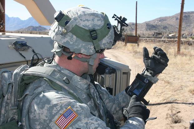
Staff Sgt. Reag Wood of 1st Combined Arms Battalion, 5th Brigade, 1st Armored Division, illustrates how he uses an iphone to obtain a visual image of a mock with insurgent activity during a field training exercise at White Sands Missile Range, N.M. (Photo: U.S. Army/Lt. Col. Deanna Bague)
A new GPS civilian signal is now available for use. The new signal is stronger, more accurate, more resilient to interference events, and interoperable with European Galileo system.
On Jan. 13 at 21:29 Finnish time, the first GPS III satellite (SVN74) was marked healthy after extensive operational testing in orbit. The satellite broadcasts PRN04 identification codes. It also transmits a new GPS civilian signal, known as L1C, different than the legacy L1 C/A signal used nowadays.
10 times longer
The two signals are transmitted at the same frequency, but L1C codes are 10 times longer than L1 C/A. This makes the signal more robust to interference when multiple satellites are tracked on the same frequency band.
“Marking a satellite health means receivers can use this satellite in their positioning, navigation and timing applications,” said Octavian Andrei, senior research scientist at the Finnish Geospatial Research Institute (FGI). “L1C is the 4th GPS signal for the civilian use.” The Finnish Geospatial Research Institute is a part of the National Land Survey of Finland.
The other three civilian signals of GPS are L2C, L5 and L1 C/A.
Interoperable with the European GNSS signalL1C signal is transmitted on L1-band at 1575.42 MHz. It is meant to replace the legacy C/A signal in the future. L1C allows for the first time GPS compatibility and full interoperability with signals from other satellite systems, such as E1 signal from the European Galileo.
The interoperability with Galileo is further enhanced by transmission of the inter-system timing biases; that is, the GPS-Galileo Time Offset. All these improvements will bring further benefits and developments to the GNSS market and civilian users in general.
Ionosphere no problem with dual-frequency
Andrei said the new signals means “Exciting times ahead for the civilian users and applications that demand precise satellite positioning and navigation. Most of the effects due to the ionosphere layers of the atmosphere are removed by combining signals from two frequency bands sufficiently apart from each other. This is the case with L1 and L2 or L1 and L5. All these civilian signals are stronger and more robust than ever before,” he explained.
The satellite signals are affected by errors while travelling through the atmosphere. The main errors are due to the ionosphere, which is a dispersive medium and frequency dependent. The latter proves to be actually a significant benefit for the precise applications.
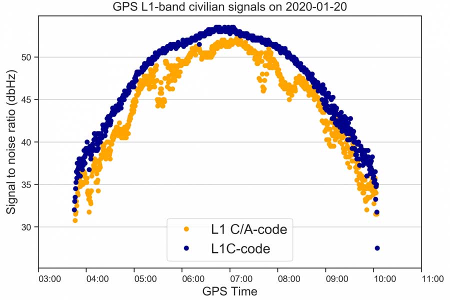
The new signal (L1C, marked with blue) is 3-5 dBHz stronger and more robust than the legacy L1 C/A signal (marked with orange). (Image: Octavian Andrei)
More than 99 % of the ionosphere effect is removed by forming special linear combination of signals observed on two different frequencies. This is the main reason why high-precision is achieved with dual-frequency receivers.
FinnRef network ready for new satellites and signals
“Two GPS III satellites have been launched until now and two more are expected to be launched during 2020. With signals from four satellites, we will also be able to estimate L1C-only positions,” Andrei said.
The first GPS III satellite SVN74, nicknamed Vespucci, was launched on Dec. 23, 2018. The second satellite SVN75, nicknamed Magellan, was launched on Aug.22, 2019. The third and the fourth satellite are planned to be launched in March and July during 2020. The first L1C testing signals were recorded at the FinnRef station in Metsähovi on April 5, 2019.
FinnRef national network includes state-of-the-art multi-constellation tracking stations distributed around Finland. These stations are capable of tracking multiple satellite signals on multiple L-band frequencies from almost 120 GNSS satellites, including the European Union’s Galileo, US GPS, Russian GLONASS, and Chinese BeiDou constellation.
Using new signals often requires updates to station equipment, usually meaning firmware updates on the receiver software. After the new firmware enabling L1C tracking is properly tested, the receivers will be updated and then whole FinnRef will start tracking GPS L1C.
What improvements will GPS III bring to high -precision surveying? When? Will these improvements require any changes in equipment and/or processes?
Tony Agresta, Nearmap
“The biggest impact of GPS III to high precision surveying will be a full constellation of L5 satellites. Triple frequency will bring faster convergence times and better accuracy in more difficult conditions. GPS III will better align with Galileo and BeiDou with L1C which means better availability in restricted sky conditions. Users will want to have equipment capable of supporting these new signals, in antenna and receiver HW as well as the signal processing done on board.” Tony Agresta
Nearmap
Jean-Marie Sleewaegen
“Of all the improvements brought by GPS III, the new L1C signal will probably have the biggest impact on high-precision surveying. Compared to L1 C/A, L1C brings better reception in difficult environments, improved availability thanks to the “pilot” component, enhanced resilience to jamming attacks, and better interoperability with Galileo, BeiDou and QZSS. Many receivers do support L1C already, but the benefits will become more tangible as the GPS III constellation grows.” Jean-Marie Sleewaegen
Septentrio
Members of the EAB
Tony Agresta Nearmap
Miguel Amor Hexagon Positioning Intelligence
Thibault Bonnevie SBG Systems
Alison Brown NAVSYS Corporation
Ismael Colomina GeoNumerics
Clem Driscoll C.J. Driscoll & Associates
John Fischer Orolia
Ellen Hall Spirent Federal Systems
Jules McNeff Overlook Systems Technologies, Inc.
Terry Moore University of Nottingham
Bradford W. Parkinson Stanford Center for Position, Navigation and Time
By Staff Sgt. Matthew Coleman-Foster, 50th Space Wing Public Affairs
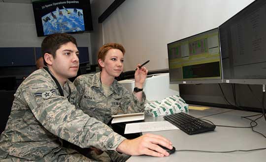
The 2nd Space Operations Squadron set Satellite Vehicle Number-74 (SVN-74, the first GPS III satellite) as healthy and active to users on the 2nd SOPS operations floor.
Setting SVN-74 healthy and active means the satellite will be available for use by military and civilian GPS users around the world as part of the constellation currently maintained by the squadron. This makes the satellite the first iteration in the GPS III family to join the active constellation following its launch Dec. 23, 2018.
Capt. Ryan Thompson, 2nd SOPS assistant director of sustainment, said various training modules and upgrades were instrumental in making the satellite operational.
“In order to operate GPS III, we first had to install Architecture Evolution Plan 8.0,” he said. “This allowed our squadron to control the new satellite without a next generation operational control system. The 2nd SOPS training and evaluations flight was able to expeditiously give our operators top-up training that allowed them to become comfortable with the new satellite.”
The GPS III vehicle family provides new capabilities vital to ensuring the fidelity of the constellation and signal in the contested, degraded and operationally limited environments.
According to the Lockheed Martin press release, GPS III satellites have three times better accuracy and up to eight times improved anti-jamming capabilities than their predecessors, and a design life extending 25 percent longer than the newest GPS satellites on-orbit today. GPS III’s new civil signal will also make it the first GPS satellite to broadcast a compatible signal with other international global navigation satellite systems, like Galileo, improving connectivity for civilian users.
2nd SOPS is already preparing for the second GPS Block III vehicle in orbit, awaiting its day to become healthy and active.
“There are vehicles currently projected to be put into the constellation and then following this there will be the Block III-F follow-on vehicles,” said Capt. Kaoru Elliot, 2nd SOPS assistant director of operations. “With those vehicles in place, all of those capabilities will come into the next decade.”
A third vehicle for GPS III is scheduled for launch later this year.
“It [GPS Block III vehicle two] is being managed currently by Lockheed Martin,” Elliott said. “They are the ones actually getting the satellites up there and once it is up in orbit, they make sure everything is good before handing it over to us.”
The work within 2nd SOPS to ensure SVN-74 is healthy and active in the constellation shows their commitment to continue providing the gold standard of position, navigation, and timing to 4 billion users around the world.
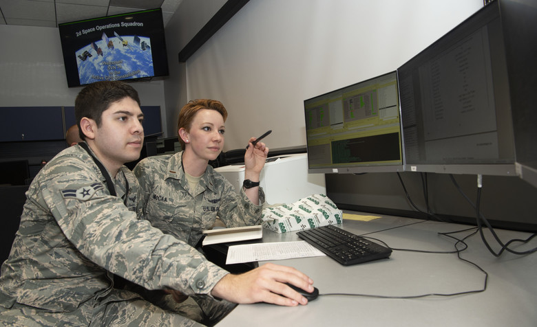
Second Lt. Kelley McCaa, 2nd Space Operations Squadron satellite vehicle operator, and Airman 1st Class John Garcia, 2nd SOPS satellite systems operator, set satellite vehicle number-74, the first iteration of GPS Block III vehicles, as healthy and active to users Jan. 13, 2020, Schriever Air Force Base, Colorado,. Setting the vehicle healthy and active makes the satellite available for use by military and civilian GPS users around the world for agriculture, banking and navigation. (Photo: U.S. Air Force/Staff Sgt. Matthew Coleman-Foster)
The U.S. Air Force Second Space Operations Squadron (2 SOPS) has issued a statement that the first GPS III satellite is available for backup. While occupying the same plane as SV-68, the new satellite is broadcasting healthy, usable signals and is an active part of the constellation in the vicinity of slot F3 near SV-68.
On. Jan. 13, 2 SOPS issued an Initial Use (USABINIT) NANU for SVN-74, the first of the new generation of GPS-III satellites, according to Rick Hamilton, CGSIC executive secretariat.
SVN-74/PRN-04 was launched on Dec. 23, 2018. Now, having successfully undergone rigorous operational testing on orbit, the satellite has taken its place, backing up SVN-68/PRN-9 at F3 in the active GPS constellation.
NOTICE ADVISORY TO NAVSTAR USERS (NANU) 2020004
SUBJ: SVN74 (PRN04) USABLE JDAY 013/1734
NANU TYPE: USABINIT
NANU NUMBER: 2020004
NANU DTG: 131735Z JAN 2020
REFERENCE NANU: N/A
REF NANU DTG: N/A
SVN: 74
PRN: 04
START JDAY: 013
START TIME ZULU: 1734
START CALENDAR DATE: 13 JAN 2020
STOP JDAY: N/A
STOP TIME ZULU: N/A
STOP CALENDAR DATE: N/A
CONDITION: GPS SATELLITE SVN74 (PRN04) WAS USABLE AS OF JDAY 013
(13 JAN 2020) BEGINNING 1734 ZULU.
POC: CIVILIAN – NAVCEN AT 703-313-5900, HTTPS://WWW.NAVCEN.USCG.GOV
MILITARY – GPS OPERATIONS CENTER at HTTPS://GPS.AFSPC.AF.MIL/GPSOC, DSN 560-2541,
By Colonel John Claxton Chief, PNT Mission Integration, Air Force Space and Missile Systems Center
Image: USAF
The Global Positioning System has provided the citizens of the United States and the world the gold standard for positioning, navigation and timing (PNT) for the past 40 years. These days, GPS is seamlessly integrated into our daily lives in ways that we hardly notice. In fact, most of us expect GPS to be available in much the same way that our lights come on when we flip a switch or water comes out when we use the kitchen faucet.
None of this is easy, however, and wouldn’t happen if it wasn’t for the incredible work and communication by the members of the GPS Program Office and our terrific enterprise partners. During the next 18–24 months, the GPS enterprise will deliver the new and more powerful modernized GPS III capabilities across all segments of the system, which have been in the works and promised for the past 8–10 years. As we transition to the Space and Missile Systems Center’s (SMC) 2.0, this is a very exciting time for the GPS program. Below are some updates on our major programs.
Program Updates
GPS III. The space segment of modernized GPS has reached our goals from 2018, and then some. SV01 “Vespucci” launched on Dec. 23, 2018, heralded by celebrations across the GPS community. The GPS III team was honored to share this event with so many giants of the GPS world. We completed space vehicle (SV) 01’s On-Orbit Checkout Test in July, meeting and exceeding all performance objectives, and plan to transfer SV01 Satellite Control Authority from SMC to the 14th Air Force by the end of the year. SV01 then begins operational testing and is expected to be certified for full operations in April 2020.
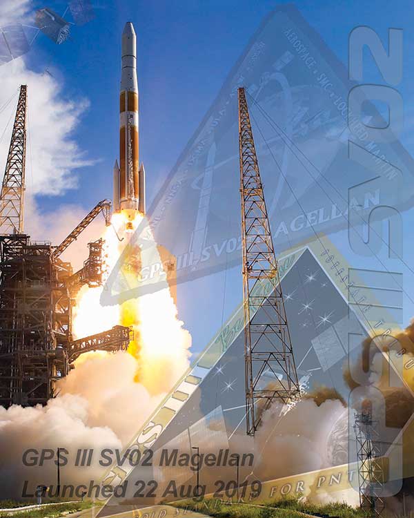
SV02 “Magellan” launched on Aug. 22 aboard a United Launch Alliance Delta IV Medium rocket — the last Delta of its class — to much fanfare and celebration as well. We completed SV02 orbit raising and initial checkout in early September, and Magellan is next in line to transition to operations in 2020.
We received delivery of SV03 and SV04 from Lockheed Martin Space Systems on May 16 and Sept. 10, respectively, with launches targeted for March and July 2020.
Challenges remain — this business is hard — but the GPS III team is focused on delivering capability: improving and streamlining the largest big-satellite production line in the Department of Defense and driving our launch campaign to bring modernized capabilities, higher power performance, and the shared international L1C signal to the GPS-using world.
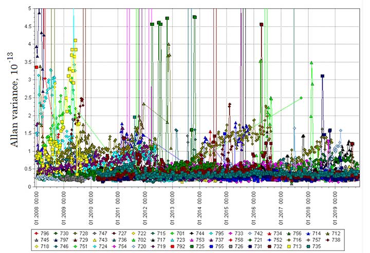
Figure 1. Mature Glonass-M satellites show improved cesium frequency standards performance in terms of daily stability. (Image: Roscosmos)
GPS IIIF. The GPS III Follow-On program looks to continue the success of GPS III as it moves forward in production of the first two GPS IIIF satellites. The program is well into a year-long set of detailed design reviews projected to conclude in March 2020. With Lockheed Martin as the prime contractor for both GPS satellite programs, GPS IIIF can take advantage of production-line improvements learned from GPS III to significantly reduce assembly, integration and test timelines.
Additionally, the program is helping to shape SMC’s Enterprise Commonality Initiative: an effort focused on aligning common products and processes across multiple programs to improve quality, speed up delivery and lower costs. With plans to procure 22 satellites and a delivery timeline spanning 15 years, the program has implemented a technology-insertion strategy and partnered with the Air Force Research Laboratory to ensure a timely transition of new capabilities to meet future military requirements. It is great to see the progress GPS IIIF is making in delivering its new baseline capabilities along with the steps it’s taking toward future capability insertion. The first GPS IIIF satellite launch is forecast for 2026.
GPS Next Generation Operational Control System (OCX). This past year, we used OCX Block 0, also known as the GPS III Launch and Checkout System, to launch and initialize both GPS III SV01 and SV02 and have been flying them in caretaker status until they are ready to be incorporated into the operational constellation. On OCX Block 1, all coding is complete, and the program focus is transitioning from development to system integration, test, and then transitioning the system to operations. Program investments over the past couple of years to change the program culture and modernize the factory infrastructure (often referred to DevOps) is paying off and yielding real-time metrics used to make data-driven decisions and produce higher quality code at a significantly faster rate. As a result, OCX is no longer troubled, but is now a typical large-complex software-intensive program that will experience challenges and risks. Fortunately, the right tools are in place to deliver this critical capability.
GPS Legacy Ground Sustainment. We continue to sustain our existing GPS infrastructure associated with the current Operational Control System (OCS). These sustainment efforts ensure GPS will continue to deliver the gold standard in PNT while providing the crucial on-ramp to incorporate the next generation of modernized GPS capabilities. We operationally accepted the largest OCS upgrade in GPS history. This upgrade, known as Version 7.5, virtualized the network, implemented two-factor authentication, secured connections to worldwide ground antennas, and improved encryption for mission data.
Challenged with a need to rapidly mitigate mission risk and provide enhanced cyber protection, the Red Dragon Cybersecurity Suite (RDCSS) emerged as the GPS OCS monitoring platform, providing data aggregation, analytics and multi-level Indicators of Compromise (IOC). It has evolved into an efficient and effective means to detect, investigate, and report security events and incidents.
Additionally, in August 2019 we established an RDCSS connection into the Space Enterprise Defensive Cyber Operations (DCO) solution, known as the Cyber Defense Correlation Cell for Space. This created a layered defense and a tiered DCO environment for protecting and sustaining the GPS mission.
GPS User Equipment. Over the past year our soldiers, sailors, marines and airmen continued testing and integrating mature, next-generation GPS receiver cards that provide more accurate and reliable positioning, navigation and timing. The first
Military GPS User Equipment (MGUE) receiver card was qualified this year, and the core technologies are being leveraged to develop many other types of GPS receiver cards for a wide range of DoD weapon systems. This exciting work is the culmination of nearly two decades of modernization efforts throughout the GPS enterprise.
In the near term, we are utilizing M-code-capable lead platforms — the USAF B-2 Bomber, USMC Joint Light Tactical Vehicle, USN Arleigh-Burke Class Guided Missile Destroyer and Army Stryker combat vehicle — to prove those capabilities. The second increment of MGUE now underway will focus on requirements for precision-guided munitions, a joint common modular handheld unit, as well as circuit cards and components for low size, weight and power needs. With MGUE, the DoD and services are poised to have enduring PNT solutions the warfighter can leverage for years to come.
GPS Integration Roadmaps
Integration of modernized GPS III capabilities into our major programs is a key focus of the GPS Program Office as we deliver capabilities to our warfighter and civilians users. We have continued to refine our plans and further integrate our programs and teams to ensure a seamless transition and continued high level of service.
Enterprise Road to Launch (ERTL). The Road to Launch team achieved an historic victory of firsts in December 2018. We successfully launched GPS III SV01, the first of its class. SMC partnered with SpaceX to launch SV01 aboard a Falcon 9 rocket — their first National Security Space Launch. SV01 reached orbit under the command and control of our first GPS OCX delivery, the GPS III Launch and Checkout System.
This colossal accomplishment of firsts was only possible because of the exceptionally close integration, tenacity and highly collaborative effort among all players in the community — spacecraft, payloads, launch, control, signal monitoring, acquisition, operations, test and many others. For SV01, the ERTL has now passed the torch to the Enterprise Road to Mission team — but the Road to Launch team is as busy as ever.
The mission planners, launch and orbital operations crew ensured SV02 reached medium Earth orbit with needle-threading precision in August; the team is implementing improvements based on experience as we prepare for up to three more GPS III launches in 2020; and we are already ramping up efforts to design the launch campaign for GPS IIIF.
GPS Enterprise Road to Mission (ERM). With two GPS III satellites now on orbit, it is now time to execute the Enterprise “Integration Playbook” we have developed and coordinated over the past year. The Contingency Operations (COps) modification upgrade has now been integrated into OCS on the 2 SOPS operations floor and is undergoing Developmental Testing with the GPS III SV on orbit. The program anticipates operational testing in January 2020 and Operational Acceptance in April 2020. All of our community stakeholders are ready, and with the COps modification to OCS in place, it is time to get the GPS III satellites into mission and start providing its new capabilities to our users. Over the next few months, the GPS III capabilities are expected to be operationally certified and ready for use.
GPS Enterprise Road to M-Code Mission (ERM-M-Code). With COps now in place, the next major delivery will be M-Code Early Use modification to OCS, installation of new M-code signal monitoring equipment at sites around the globe, modification of mission planning software, MGUE Increment 1 development, service lead platform integration efforts, and operationalization of space receivers. It is our continued objective to improve the ability of the Combined Space Operations Center, to respond to urgent PNT needs of the combatant commanders as they engage more sophisticated adversaries. We remain closely aligned with our peers at USSTRATCOM, AFSPC and our worldwide users across the Joint Service and allied team.
Conclusion
It has never been a more exciting time to be part of the GPS program and enterprise. Our outstanding government and contractor teams have worked so incredibly hard on integrating and communicating our programs to ensure the successful and seamless delivery of GPS III capabilities to both our warfighter and civilian users. It is a great world we live in today, and GPS makes it even better.
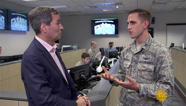
On CBS’ Sunday Morning show Dec. 1, correspondent David Pogue was invited into the Air Force’s GPS Master Control Station at Schriever Air Force Base in Colorado Springs, Colorado, to show viewers what GPS is all about.
Pogue discussed the GPS program with Brigadier General DeAnna Burt, who oversees the program as the director of operations at Air Force Space Command at Peterson Air Force Base in Colorado Springs.
He also discussed GPS vulnerabilities with Dana Goward, president of the Resilient PNT Foundation and contributor to GPS World magazine.
Pogue also visited Lockheed Martin’s satellite assembly facility, where the new generation of GPS III satellites is being built.
The GPS enterprise reached another major milestone on Oct. 21, when the GPS III Contingency Operations Program (COps) successfully connected with the first GPS III satellite on orbit.
The COps system will allow the Air Force to operationally command and control the new, more powerful GPS III satellites as well as legacy GPS satellites currently in the constellation. The first GPS III satellite was launched on Dec. 23, 2018.
After final system test, the Air Force approved installation of COps to command and control legacy operations at the Master Control Station at Schriever Air Force Base in Colorado Springs, Colo., and at the Alternate Master Control Station at Vandenberg, Air Force Base near Lompoc, Calif.
Trial period begins. In October 2019, the COps program received approval from Air Force Space Command’s Operations and Communications Directorate (A3/6) to enter a trial period.
The trial period includes testing COps command and control with the live, on-orbit GPS III satellite, which allows the program office to conduct developmental and operational testing needed to thoroughly verify requirements and functionality of the satellite.
The testing aims to confirm readiness for operational acceptance targeted for December 2019 and April 2020 for the GPS III satellite and COps respectively.
The GPS III COps program is managed by the U.S. Air Force Space and Missile Systems Center, Production Corps, Command and Control Systems Division, located at Los Angeles Air Force Base in El Segundo, California.
The Production Corps is an 800-plus person team managing 26 programs across the Air Force’s space portfolio.
Raytheon plans to deliver the final phase of the GPS Ground Control System (OCX) upgrade to the United States Air Force by June 2021, despite past delays to the program.
A report by the General Accountability Office (GAO), issued in May, said the Air Force has yet to develop full cost estimates for the new ground system, as well as the user equipment needed to access the expanded capabilities of GPS III.
In the report, the GAO recommended that the Department of Defense (D0D) conduct an independent schedule assessment of the full program schedule at the end of 2019. DOD did not agree with the recommendation.
“OCX delivery, acceptance, and the ready to transition to operations decision will likely be delayed, potentially exceeding the April 2023 threshold date for completing the program,” the GAO report said.
However, Raytheon said Oct. 1 that it had completed software and hardware development and has started testing and integrating the system, keeping it on track to meet its contractual deadline.
In an Oct. 1 Denver Post article, David Wajsgras, president of Raytheon’s Intelligence, Information and Services business, said Raytheon has changed its process for the OCX upgrade by adopting less-traditional tech startup development processes.
The new process —now in action at Raytheon’s Aurora, Colorado, campus — emphasizes collaboration across teams and has a less linear structure.
“I’d call it almost a 180 from the way we had developed software in the past, from the traditional way for the Department of Defense,” Wajsgras told the Post.
“A few years ago the GPS OCX program was considered the No.1 problem program in the entire Department of Defense,” Wajsgras acknowledged. “Our team truly stepped up to the challenge of what needed to be done in order to get one of the most important programs for U.S. government back on track.”
DOD’s Defense Digital Service helped the company apply an “agile” approach to “DevOps” (development and operations) that stresses collaboration across teams as well as flexibility.
The new process includes “dojos,” centers for focused, quick training, and “hives,” open workspaces without cubicle walls.
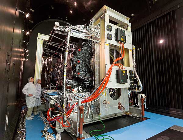
Thermal Vacuum testing verifies that a satellite can operate in space’s extreme environment. (Photo: Lockheed Martin)
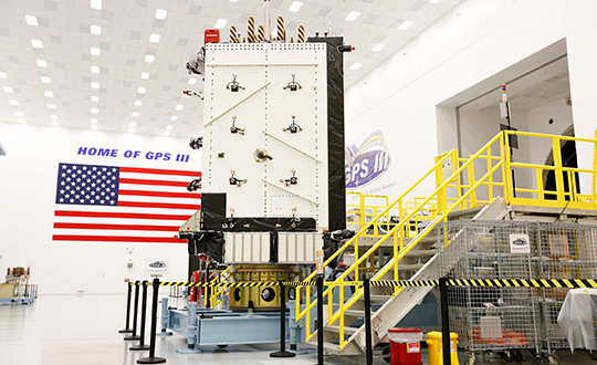
With GPS III SV01 and SV02 now on orbit, GPS III satellites continue to roll off the production line at Lockheed Martin’s GPS III Processing Facility near Denver.
Johnathon Caldwell, Lockheed Martin Space’s vice president for navigation systems, provided GPS World with an update to the entire GPS III family.
SV01. The first GPS III satellite is in a holding state pending readiness by 2SOPS [the Second Space Operations Squadron] to take the vehicle onto the system for operational checkout, a transfer expected to take place later this year, Caldwell explained. The satellite completed on-orbit testing in July.
“We’re in the process of getting the 2SOPS crews trained up to operate a GPS III vehicle,” Caldwell said. “By the end of this year, they will be able to take [SV01] into the constellation and start flying it as a live, set-healthy vehicle.”
SV02. Launched Aug. 22, SV02 is following in the footsteps of its older sibling, with a quiet checkout and no major findings. Like SV01, once it completes testing, it will stay in temporary holding until 2SOPS is ready to bring it into the constellation.
SV03. On May 27, the Air Force declared SV03 available for launch. It is now in final preparations for shipment, with an expected launch date in January 2020 aboard a Falcon 9 rocket.
SV04. The Air force declared SV04 available for launch; it is now in storage awaiting a launch date.
SV05. The fifth satellite is wrapping up environmental tests. Lockheed Martin anticipates that it will be available for launch early next year.
SV06. The satellite has been moved into the thermal vacuum testing chamber and begun a rigorous testing campaign before it meets the harsh environment of space.
SV07, SV08 and SV09 are on the assembly line.
GPS IIIF Satellites. In 2018, the Air Force selected Lockheed Martin to build up to 22 GPS IIIFs, adding new features and resiliency to the original GPS III satellite design. The company has been on the path to meet the critical design review for the GPS IIIF spacecraft, which is due to take place next spring.
Program enters integration and test phase on track to 2021 delivery
Raytheon Company’s GPS Next-Generation Operational Control System, known as GPS OCX, has completed full software and hardware development and entered the system integration and test phase. The milestone keeps GPS OCX, the enhanced ground control segment of a U.S. Air Force-led effort to modernize America’s GPS system, on track to meet its June 2021 contractual delivery deadline.
“GPS OCX is one of the largest, most complex software development programs in the Department of Defense, and we’re now in the home stretch toward full system delivery,” said Dave Wajsgras, president of Raytheon’s Intelligence, Information and Services business.
The GPS OCX team completed development of 1.5 million lines of software code, supported by a pivot to leading-edge commercial software development processes that began in 2016. Additionally, the team’s information assurance best practices helped the program achieve the highest level of cybersecurity protections of any DoD space system.
The U.S. Air Force used the cybersecure GPS OCX launch and checkout system, often referred to as Block 0, to launch the first modernized GPS III satellite into space in December 2018 and the second in August 2019.
The team’s focus for the remainder of 2019 is the delivery of the system’s new modernized receivers, which will measure and monitor legacy military and civilian signals sent by the current GPS satellite constellation plus the new signals sent by the next-generation GPS IIIs.
Ground antenna at Schriever Air Force Base, home of the 50th Space Wing. (Photo: Raytheon)
GPS OCX will maneuver satellite into final orbit over 10 days
The U.S. Air Force used Raytheon Company’s GPS Next-Generation Operational Control System, known as GPS OCX, to support the launch of its second GPS III satellite into space. The ground system will now spend 10 days maneuvering the satellite into its final orbit, demonstrating GPS OCX’s ability to simultaneously support multiple GPS III spacecraft on-orbit throughout the checkout and calibration process.
Raytheon’s GPS OCX has obtained the highest level of cybersecurity protections of any Department of Defense space system.
“GPS OCX performed extremely well during the first launch and has exceeded performance requirements in the months since,” said Dave Wajsgras, president of Raytheon Intelligence, Information and Services. “The team was well-prepared for this launch, and we’re confident the system’s performance will continue to be positive.”
GPS OCX, the enhanced ground control segment of America’s GPS system, has achieved the highest level of cybersecurity protections of any Department of Defense space system. Its open architecture design allows it to integrate advanced protections as they become available, and the system’s industry-leading cyber protections are why it will be used to support all future GPS III launches and GPS constellation operations upon operational acceptance.
Earlier this year, the team completed final qualification testing of the system’s modernized monitor station receivers, which can receive and decrypt all GPS III military and civil signals. Global installation of the receivers starts next month and keeps the program on track for full system delivery by the program’s June 2021 contractual deadline.
In addition to GPS OCX’s role, RGNext, a joint venture between Raytheon and General Dynamics Information Technology, provided operational launch support to ensure the safe launch of the United Launch Alliance’s Delta-IV rocket that was carrying the GPS III satellite. RGNext operates the launch range on behalf of the U.S. Air Force, providing maintenance, range safety, weather monitoring, communication and surveillance support for all launches conducted by defense, civil and commercial companies at the range. To access our press kit, which includes photos, videos and an animation, please visit us here. To learn more about the program’s progress and additional capabilities, visit us here.