Tag: GSA

  • An Early Gift from — and for — Galileo

    They said it wasn’t possible — well to be frank, I said it wasn’t possible – but one of the two “misplaced” Galileo satellites, plucky Doresa, has delivered an early Christmas present to the European GNSS community by providing a first fix on Tuesday, December 9. The signal was received at the European Space Agency’s (ESA’s) technical centre in Noordwijk, the Netherlands and at the Galileo In-Orbit-Validation (IOV) test station at Redu in Belgium. Doresa teamed with the remaining three functioning Galileo IOV satellites to provide a Galileo positioning data first fix with horizontal accuracy better than two metres.

    Since then fixes have also been performed using Galileo’s Public Regulated Service (PRS), the civilian encrypted highest-precision signal and one of the constellation’s unique selling points.

    The satellite had transmitted its first navigation signal in space on November 29, following its attainment of a safer, more stable, and more circular orbit with the perigee some 3,500 kilometres higher than its original placement.

    Doresa’s salvage has been a slow and steady journey since it was placed, with sister satellite Melina, into a fairly useless orbit in August following a launch anomaly. The original orbit, with a 26,000-kilometer apogee and a 13,800-kilometer perigee, prevented their use for navigation services because they were too low during part of their orbit to sense the horizon and correctly determine their own position. They were also getting a daily dose of radiation from the Van Allen belts.

    Elevation

    The elevation of the satellite started in late October and involved 11 firings of Doresa’s on-board thrusters. The craft now has only 15 kilos left from its original 65 kilo fuel payload but, given the fact that normally Galileo satellites are not required to make regular orbital manoeuvres, ESA engineers estimate this should be enough for a good 12 years of operation in the new orbit.

    The next stage will be to repeat this manoeuvre with the second Full Operational Capability (FOC) satellite, Melina, according to a plan to get that into a similar orbit by the New Year. Pending tests of their positioning, navigation, and timing payloads, the two spacecraft are then likely to be able to contribute to the future Galileo navigation constellation. This was confirmed by Didier Faivre, ESA’s director for navigation, during the agency’s ministerial council meeting on December 2 in Luxembourg.

    This end result is the best possible scenario given where the satellites were left after launch and is a considerable triumph for ESA’s mission control teams and flight engineers. Doresa is now able to use its Earth sensor continuously and keep its antennae orientated towards the Earth. Despite more than a month’s exposure to the Van Allen radiation, testing so far has shown no ill effects.

    “The very good geometry of the satellites in the sky relative to the receivers helped us to achieve this result, plus the signal strength of the fifth satellite,” explained Gustavo Lopez Risueno, coordinating the receiver team at the Navigation Laboratory in ESA’s ESTEC technical centre.

    The satellite signals should be usable immediately, in combination with additional navigation message information provided through ground networks, with mass market receivers. In fact the ESTEC Navigation Laboratory, working in conjunction with the European Commission and the European GNSS Agency (GSA), have already performed position fixes with both Galileo and GPS satellites using only navigation-assistance information.

    With some adjustments to the Galileo network’s ground infrastructure, it looks like Doresa and Melina will be able to carry out most of the roles they were originally designed to do. They are the first of 22 Galileo FOC satellites to be built by OHB and launched by ESA over the next few years.

    Toasted antennae

    More good news. The problem with Galileo’s fourth IOV satellite, named Sif, that took it out of action at the end of May seems to have been characterised and — again — indicates that the satellite is not a complete loss to the constellation. While Sif’s E5 and E6 frequency bands are definitively blown, the satellite’s E1 Open Service band should be capable of broadcast.

    The problem appears to have been a defective antennae. The four IOV satellites utilise one antennae design, while the FOC satellites have a different design. Fortunately there is no sign of a similar issue with the three other IOV craft, but they have been operating on reduced power as a precaution while the root cause of Sif’s failure is determined. ESA is currently fail-testing an example of the culprit antennae in the laboratory to see if the failure mode can be characterised.

    “One of the possible root causes links the problem with the power emitted by the antenna. When we know more we’ll decide what to do with the other three. Since this event occurred in May and June, no more issues have arisen,” Faivre said.

    Agreement

    This is all a remarkable turnaround and good news for the wider European GNSS community and those stakeholders who have invested in the Galileo programme and its burgeoning application industry. Let’s hope the good fortune continues through 2015.

    The administrative side of things is certainly moving on with the signing in October of an agreement which delegates a range of exploitation tasks for Galileo from the European Commission to the GSA, providing a framework and budget for the development of services and operations through to 2021.The signing of the agreement is an initial step towards the full Galileo Exploitation Phase. Current planning calls for this exploitation phase to be progressively rolled out from 2015, with full operability scheduled for 2020.

    “With Galileo, we aim to provide a tangible service to European citizens, and this Delegation Agreement ensures we have the tools and funding necessary to achieve this,” said GSA Executive Director Carlo des Dorides. The agreement was signed by Daniel Calleja Crespo of the European Commission and des Dorides. The document specifically sets the actions to be implemented, the amount of funding provided, and the conditions for the overall management.

    Innovation

    In the same month, the First Satellite Masters Conference took place in Berlin on October 23 and 24. The conference encompassed the 2014 edition of the European Satellite Navigation Competition (ESNC). The event was a great showcase for the innovation, skill, and passion of the entrepreneurs, usually young, who are building the satellite application market in Europe.

    For example, the winner of the GSA special prize at ESNC 2014 is developing Galileo modules for the Google Ara modular smartphone concept, a potential game-changer for positioning in the mobile-phone market. Ara uses interchangeable modules to deliver a smartphone that can be whatever a user wants it to be, complete with first- and third-party components including sensors, cameras, radio antennas, and more. Consumers will be able to order them as of January 2015.
    Google developers believe an Ara smartphone will last multiple years, much longer than current hardware, since it won’t be obsolete nearly as quickly. Further, Ara could open the smartphone market to billions of new users across the globe.

    I spoke with Giovanni Vecchione of Deimos Space, who received the € 40 000 GSA/ESNC prize during the awards ceremony at Deutsche Telekom’s magnificent headquarters in the German capital.

    “With a traditional chip structure, all of a smartphone’s functions are currently combined into a single component, which makes it difficult to add or change a function,” explained Giovanni. “With a modular structure, you have the option to simply switch out a component, meaning a smartphone’s capabilities can be easily enhanced.”

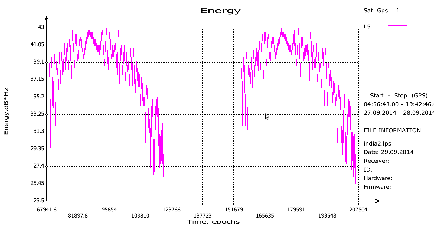
    Vecchione’s innovation is to use another of Galileo’s unique selling points: the E5 broadband signal. While mass market smartphones will use the E1 signal, the availability of high-end phones offering enhanced accuracy through the use of the E5 signal will appeal to many users. A second module will implement an external antenna interface. Together these developments could deliver an ARA phone offering high precision (centimetre-level accuracy) positioning and multipath-resistant solutions.

    Wishing you all a very peaceful and prosperous New Year and hoping Santa has your coordinates accurately entered in his sleigh satnav!

    A bientôt, as they say in these parts.

  • GSA Kicks Off EGNOS GEO Transponder Service Contracts

    On November 25, the European GNSS Agency (GSA) kicked off the contracts for two new EGNOS GEO transponder services provided by SES.

    The kick-off was done with the support of the European Space Agency (ESA) and the EGNOS service provider ESSP. Initially awarded and signed by the European Commission, in line with a new delegation agreement  between the commission and the GSA, responsibility for the oversight of the contracts has been assigned to ESA.

    The contracts regard the provision of signals from two EGNOS transponders embarked on-board the SES-5 and ASTRA-5B geostationary satellites, both operated by Luxembourg-based SES. The ground-based signals are generated via redundant uplink stations located in Betzdorf, Luxembourg and Redu, Belgium.

    The signals include the navigation messages computed by the EGNOS Mission Control Centers. Both satellites are capable of transmitting dual-frequency signals compliant with GPS L1/L5 and Galileo E1/E5 signal specifications. The signals will be introduced into the EGNOS service provision (L1-only signals) between 2015 and 2016.


  • The System: Fregat Design Ambiguity Steered Galileo Wrong

    Cross-Installed Hydrazine, Helium Lines Froze Thrusters

    The root cause of the anomaly that sent two Galileo satellites into the wrong orbit on August 22 was a shortcoming in the system thermal analysis performed during stage design, and not an operator error during stage assembly, according to findings by an independent inquiry board.

    The independent inquiry board was created by Arianespace, in conjunction with the European Space Agency and the European Commission. Its conclusions draw on data supplied by Russian partners in the program, and are consistent with the final conclusions of the inquiry board appointed by the Russian space agency Roscosmos.

    The anomaly occurred during the flight of the launcher’s fourth stage, Fregat, designed and produced by NPO Lavochkin. It occurred about 35 minutes after liftoff, at the beginning of the ballistic phase preceding the second ignition of this stage.

    The board’s conclusions confirm that the first part of the mission proceeded nominally, which means that the three-stage Soyuz launcher was not at fault. The inquiry board also eliminated the hypothesis that the anomaly could have been caused by the abnormal behavior of the Galileo satellites.

    The scenario that led to an anomaly in the orbital injection of the satellites was precisely reconstructed, as follows:

    The orbital error resulted from an error in the thrust orientation of the main engine on the Fregat stage during its second powered phase.

    This orientation error was the result of the loss of inertial reference for the stage.

    This loss occurred when the stage’s inertial system operated outside its authorized operating envelope, an excursion that was caused by the failure of two of Fregat’s attitude-control thrusters during the preceding ballistic phase.

    This failure was due to a temporary interruption of the joint hydrazine propellant supply to these thrusters. The interruption in the flow was caused by freezing of the hydrazine.

    The freezing resulted from the proximity of hydrazine and cold helium feed lines, these lines being connected by the same support structure, which acted as a thermal bridge.

    Ambiguities in the design documents allowed the installation of this type of thermal “bridge” between the two lines. In fact, such bridges have also been seen on other Fregat stages now under production at NPO Lavochkin.

    The design ambiguity is the result of not taking into account the relevant thermal transfers during the thermal analyses of the stage system design.

    The system thermal analyses have been reexamined in depth to identify all areas concerned by this issue. The board has chosen these corrective actions for the return to flight.

    • Revamp of the system thermal analysis.
    • Associated corrections in the design documents.
    • Modification of the documents for the manufacture, assembly, integration, and inspection procedures of the supply lines.

    Arianespace said these measures can immediately be applied by NPO Lavochkin to the stages already produced, meaning that the Soyuz launcher could be available for its next mission from the Guiana Space Center in December.

    “We are looking at the resumption of Soyuz launches from the Guiana Space Center, as early as December 2014,” stated the Arianespace CEO. “The resolution of this anomaly will enable a consolidation of the reliability of Fregat, which had experienced 45 consecutive successes until this mission.” 

    Galileo Service Controls Handed to GNSS Agency

    Full Operability Set for 2020

    The European GNSS Agency (GSA) and the European Commission have concluded an agreement that delegates a range of exploitation tasks for Galileo to the GSA, providing a framework and budget for the development of services and operations through 2021.

    The signing of the Galileo Exploitation Delegation Agreement serves as an initial step towards the full Galileo Exploitation Phase. According to the governance structure set out in the agreement, the European Commission is responsible for the overall programme supervision, the European Space Agency (ESA) is entrusted with the deployment phase, while the GSA is responsible for the exploitation phase. The GSA’s responsibilities include:

    • provision and marketing of the services
    • management, maintenance, continuous improvement, evolution and protection of the space and ground infrastructure
    • research and development of receiver platforms with innovative features in different application domains
    • development of future generations of the system
    • cooperation with other GNSS
    • all other required activities to ensure the development and smooth running of the system.

    “With Galileo, we aim to provide a tangible service to European citizens, and this Delegation Agreement ensures we have the tools and funding necessary to achieve this,” said GSA Executive Director Carlo des Dorides.

    Full operability of Galileo is now scheduled for 2020, a slight revision of the previous 2018 projection.

    The agreement specifically sets the actions to be implemented, the amount of funding provided, and the conditions for the overall management. The maximum current EU contribution amounts to EUR 490 million, which will cover procurement and grant activities, including the GSA-ESA working arrangements and a programme management reserve, along with related research and development activities. The financing of the full exploitation phase will be confirmed during a mid-term review before the end of 2016.

    India Launches Third Satellite and ICD

    India successfully launched IRNSS-1C, the third satellite in the Indian Regional Navigation Satellite System (IRNSS), on October 16. The satellite was injected to an elliptical orbit of 282.56 x 20,670 kilometers, very close to its intended final geostationary orbit at 83 degrees East longitude. 

    IRNSS-1C is the third of the seven satellites constituting the space segment of the Indian Regional Navigation Satellite System. Tthe first two were launched in July 2013 and April of this year. Both are functioning satisfactorily from their designated geosynchronous orbital positions. 

    IRNSS is an independent regional navigation satellite system designed to provide position information in the Indian region and 1,500 kilometers around the Indian mainland. IRNSS will provide two types of services: Standard Positioning Services (SPS), provided to all users, and Restricted Services (RS), provided to authorized users. Ground stations have been established in at least 15 locations across India.

    The next satellite of the constellation, IRNSS-1D, is scheduled to be launched in the coming months. The full IRNSS constellation of seven satellites is planned to be completed by 2015.

    IRNSS ICD Released. In late September, the Indian Space Research Organization (ISRO) released version 1 of the IRNSS Signal in Space Interface Control Document (ICD) for the Standard Positioning Service.

    The document provides information on the signals and structures of the IRNSS system, including signal modulations, frequency bands, received power levels, the data structures and their interpretations, and user algorithms.

    Registration is required for ICD download access at a new IRNSS website

    JAVAD Tracks Signal. JAVAD GNSS published a chart showing that it has tracked the IRNSS L5 signal.

    Shortly after ISRO released its IRNSS Signal in Space Interface Control Document (ICD), JAVAD GNSS tracked the L5 BPSK signal from both 1A and 1B satellites. Ability to track IRNSS L5 will be added to all JAVAD L5-capable receivers in the near future, the company said.

    SNR of two passes of 1A satellite (IGSO) over Moscow.
    SNR of two passes of 1A satellite (IGSO) over Moscow.

    Let’s All Be GPS III for Halloween

    As this magazine goes to press on October 23, the U.S. Air Force is set to launch the eighth GPS IIF satellite from Cape Canaveral Air Force Station on Wednesday, October 29.  An 18-minute launch window will open at 1:21 p.m. U.S. Eastern time. If all goes well, the satellite will be accomplishing its early-orbit checkouts and beginning maneuvers towards its final orbital plane as U.S. children make their costumed Halloween rounds, collecting candy. Other Western countries celebrate All Hallows’ Eve followed by All Saints’ Day on November 1.

  • EC, GSA Plan Workshop on GNSS Receiver Technology

    On November 18, a Consultation Event will take place in Brussels on the subject of receiver technology. The event is being held to inform the stakeholders of the European GNSS receiver community about the format and timeline of funding opportunities for the period 2015-2020, and to gather input for the definition of R&D actions in the field of receiver technology.

    The event is being organized by the European Commission’s Directorate-General Enterprise and Industry,  in collaboration with European GNSS Agency (GSA).

    The workshop will consist of one panel session, during which stakeholders from industry, SMEs, academia, and technology institutes will be asked to debate and recommend important lines of research in receiver technology.

    Registration is now open on the Europa website. Interested participants are invited to fill in the registration form and to indicate which application area they are interested in and the fields of research that should be supported.

    The workshop will be held at the Committee of the Regions, Jacques Delors building, rue Belliard 99-101, room JDE 53, Brussels.

  • GSA, EuroControl Sign Agreement on GNSS for Aviation

    In the presence of the European Commission, the European GNSS Agency (GSA) and EuroControl have signed a new cooperation agreement to jointly contribute to the implementation of European Union GNSS policies as they apply to the field of aviation.

    As Europe’s skies and major airports become increasingly congested, there is need for Air Traffic Management (ATM) technologies to evolve from ground-based infrastructures to more advanced systems based on new technologies. EuroControl and the GSA have a shared objective in developing and exploiting European GNSS technology to improve accessibility, efficiency and safety to European operators, pilots and airports.

    To accomplish this objective, the agreement focuses on a range of activities, including:

    • Definition of aviation user requirements for EGNOS and Galileo
    • Introduction of European GNSS services for aviation within the European Civil Aviation Conference (ECAC) area
    • Coordination in aviation research and development
    • Aviation-specific GNSS performance monitoring
    • Promotion of European GNSS aviation activities at the international level

    “This is another example of European Commission support of the aviation sector,” said Daniel Calleja Crespo, director general of DG Enterprise and Industry at the European Commission. “I am confident that a strong cooperation between the GSA and EuroControl will benefit aviation, the European GNSS Programs and indeed European citizens.”

    “The full deployment of GNSS offers unprecedented opportunities to further improve air traffic management safety and capacity, while reducing costs at pan-European level,” said GSA Executive Director Carlo des Dorides. “EuroControl’s activities in this field will complement those of the GSA to ensure that the development and implementation of satellite-based navigation provides an optimal solution for European airspace users.”

    “EuroControl and the GSA share a common objective — the secure and safe implementation of European satellite navigation policies in the aviation sector. The enhanced cooperation between our two organizations means that EuroControl will now bring its unequaled capacity to understand, coordinate and represent the needs of the civil and military airspace users to the promotion and development of GNSS,” said Frank Brenner, director general of EuroControl.

    EGNOS is Europe’s first venture into satellite navigation and has been providing a certified safety service for aviation users since 2010. EGNOS is owned by the European Union and, since January 1, 2014, the GSA is responsible for its exploitation, ensuring service provision, operations, maintenance and evolution.

  • Test Shows Galileo Increases Accuracy of Location-Based Services

    The European GNSS Agency (GSA) and Rx Networks Inc., a mobile location technology and services company, announced the results of tests conducted by the company measuring the performance of Galileo when used in various combinations with GPS and GLONASS.

    Tests were conducted in real-world environments, including urban canyons and indoors. These environments pose significant challenges to location accuracy due to multipath and obstructed views of satellites. Each test consisted of a three-hour data capture of GNSS signals, which was later replayed to produce hundreds of fixes using a multi-constellation GNSS receiver from STMicroelectronics.

    The results showed that using Galileo with one or more other GNSS constellations provides significantly more accurate location fixes compared to GPS alone, when indoors or in urban canyons. As expected, the GPS+Galileo combination did not exceed the performance of GPS+GLONASS, due primarily to there only being four Galileo satellites available at the time of the testing. It is expected that, as more Galileo satellites are launched, the combination of Galileo with GPS will show further improvements in performance, GSA and RX Networks said.

    According to Gian-Gherado Calini, head of Market Development at the GSA, “Dual-constellation GNSS designs are the standard for many smartphones and other devices. The combination of GPS and Galileo provides a robust solution and is expected to offer performance that will meet or exceed end-user expectations.”

    “The results should be encouraging to any GNSS chipset manufacturer who is considering adding Galileo as a competitive differentiator,” said Adrian Stimpson, senior vice president of Sales and Marketing, Rx Networks.

    Test Results

    Recent test results confirm that Galileo significantly improves accuracy in challenging environments:

    GSA-Positive-Test-Results-27-May

    The tables above show the summary results for various scenarios and constellation combinations. The GPS row shows the absolute 2D errors in meters. All other rows show the improvement (+) or degradation (-) in meters and percentages relative to GPS-only fixes. All measurements are within the 95th percentile.

  • Out in Front: A Glow under the Snow

    Out in Front: A Glow under the Snow

    Prague is now the headquarters of the European GNSS Agency (GSA).
    Prague is now the headquarters of the European GNSS Agency (GSA).

    A holiday card from a colleague in Europe calls to mind GNSS’s headlong course into the future, coupled with that most backward-reflective of human preoccupations, history.

    The European GNSS Agency (GSA), whence originated this card, moved from Brussels to Prague in September 2012, in a nod to the pan-European nature of the European Union (EU) generally and its GNSSs, Galileo and EGNOS, in particular. No EU agency headquarters had been sited in Eastern Europe, and it was deemed that some soon must do. Prague made a strong bid for the GSA.

    A political, cultural, and economic center of central Europe under its current name since the year 908, it has a settlement history dating back to 1306 BC. Good King Wenceslaus, who looked out upon the snow round about, deep and crisp and even, and about whom we sang festively this past season, ruled from Prague around 935, subsequently rose to sainthood, and is the patron saint of Bohemia, the Czech homeland.

    The GSA has a rather variegated mission: it “manages public interests related to European GNSS programmes.” This includes everything from marketing to security — in a sense, everything satnav-related that scientists and engineers do not do. Its list of tasks and responsibilities includes 12 subheads and 61 bulleted points.

    Carlo des Dorides, GSA executive director, noted upon opening the new headquarters in 2012 that Prague derives from the Slavic word praga, for threshold. “I think this is appropriate for the GSA and Galileo, as it represents the beginning of a key step for both.” EC vice-president Antonio Tajani added, “Galileo is important not only for space policy and science, but for the services and jobs that it brings.”

    Thus the many GSA staffers labor to wring full advantage for modern economies from the space-based radio signal generators, amid the cobblestone streets and ancient monuments of one of the best-preserved ancient European cities, a UNESCO Cultural Heritage site.

    While busily plunging into the future, we cannot escape our past.

  • A Glowing Report Doth Not a Golden Future Make

    The tech press and broad public media have both made much ado about a November market report from the European GNSS Agency (GSA). Most accounts have focused on a GSA prediction of an installed base of 7 billion GNSS-enabled devices worldwide by 2022, and nearly every account has replicated the GSA math to trumpet “almost one for every person on the planet.”

    Oh Hosanna.  We (will) have reached holy ground at last.

    Other than asserting that this bonanza “has the potential to deliver additional significant benefits, not measured in this report, especially in terms of time and fuel savings, as well as efficiency gains,” neither the GSA itself nor any pundit’s account of the report that I have seen ventures to speculate on how this might actually change daily human life. Hopefully ‘twill not be on the order of how cell phones have affected society, communication, and interaction; read tweeting and social-network stress. But knowing what little we do about human nature, this possibility is not at all to be discounted.

    Allow me to walk the plank out into left field long enough to quote from a 2009 NBC News Science report titled “Is Twitter evil?”  “Researchers probing the workings of the brain have found that it takes longer for feelings of social compassion and admiration to register on our neural circuits — and they worry that the rapid-fire effect of texting and tweeting could have ‘potentially negative consequences’ for our moral fiber.”

    Could total, global, continuous, pervasive location-awareness in the palm of everyone’s hand possibly lead down a similar path? I’m sure that cell-phone enthusiasts also promised vast, billionish-plus benefits, with absolutely no downside, three decades ago.

    If I can pry myself back from Nostradamus mutterings — and I am sure you are glad that I have now done so — the GNSS Market Report Issue 3 contains a great deal of data worth considering.

    Said document foresees compound annual growth rates (CAGRs) for “GNSS core” and “GNSS-enabled” revenues increasing by 9 percent through 2016 and 5 percent through 2020, to attain €350 billion ($478 billion) per year. Of the 2022 total, GNSS core revenues will comprise about €100 billion (US$137 billion).

    To further differentiate “core” and “enabled,” this from the report’s early Market Definitions section:

    “This market report primarily considers the core GNSS market. For multi-function devices, such as smartphones, the core market includes the value of GNSS functionality only (rather than the full device price) and service revenues directly attributable to GNSS functionality (e.g. data downloaded by smartphones to use Location-Based Services).

    “For multi-function devices, a correction factor is taken into account, for example:

    • GNSS-enabled smartphone: only the value of GNSS chipsets is counted, estimated at 1% of the price.

    • Personal Navigation Devices (PNDs): 100% of retail value since GNSS is the key enabler.

    • Aviation: the value of the GNSS receiver inside the Flight Management System is taken into account.

    • Precision agriculture system: the retail value of the GNSS receivers, maps, and navigation software is counted.

    “The Executive Summary also presents results for the enabled market. The enabled market represents the services and devices enabled by GNSS, and includes the core market. For the enabled market, the entire retail value of the smartphone is included.”

    The 72-page report breaks out market segments, focusing in turn on: location-based services (LBS), road, aviation, rail, maritime, agriculture, and surveying. The weight of the report, as you might guess by the necessity of reaching that 7 billion figure, falls primarily on LBS, a heading that for the GSA encompasses “smartphones, tablets, digital cameras, laptops, fitness and people-tracking devices, and mobile-data revenues.”

    What’s good for the mass market must surely be good for satellite makers and operators around the world, as they attempt the jump from one to many systems.  That’s the underlying but unstated premise of the report.  “Multi-constellation receivers become widely available on the market” trumpets the Executive Summary headline on page 8.  In what is certainly the money pitch for the Prague-based, European Union-funded agency, “Galileo is recognised as a valuable element in multi-constellation systems, and it is already present in more than 30% of receiver models, well ahead of its full operational capability.”

    Nevertheless, GLONASS is the second GNSS constellation choice of receiver manufacturers after GPS.

    For BeiDou, the researchers will only venture that “Several equipment manufacturers, particularly those based in Asia-Pacific, have started to offer BeiDou-enabled models.”

    More than 70 percent of models on the market are GPS-SBAS capable (SBAS comprising WAAS, EGNOS, and MSAS) and this penetration will grow further.

    In a final provocative note (neither final nor provocative from the GSA’s point of view, although I confess it causes me a vague unease), the four-fold increase in the number of GNSS devices will be “largely driven by increased penetration in regions outside Europe and North America.”

    Production of the report relied on “advanced forecasting techniques together with a validation process with market experts.”

    Lest you feel unfairly treated by my curmudgeonly take, here is some actual data generated by and taken from the report.

    Global GNSS Market Size, from GNSS Market Report 2013 Issue 3
    Global GNSS Market Size, from GNSS Market Report 2013 Issue 3
    Installed Base of GNSS Devices by Region, from GNSS Market Report 2013 Issue 3
    Installed Base of GNSS Devices by Region, from GNSS Market Report 2013 Issue 3
    GNSS capability in receivers, from GNSS Market Report 2013 Issue 3
    GNSS capability in receivers, from GNSS Market Report 2013 Issue 3


  • GSA Begins Preparations for Future EGNOS Services

    The European GNSS Agency (GSA) Wednesday published a contract notice in the Official Journal of the European Union inviting operators to bid for the provision of EGNOS services over the 2014-2021 period. This contract will consist in operating, maintaining and upgrading the EGNOS system infrastructure, and ensuring the continuous and safe provision of the three services offered by EGNOS.
     
    The new EGNOS service provision contract is planned to be awarded in 2013 and is aimed at guaranteeing the provision of EGNOS services for eight years starting on January 1, 2014, without service interruption. The future EGNOS operator shall become certified for provision of the EGNOS services according to the Single European Sky (SES) regulation. The requests to participate shall be transmitted to the GSA by July 16 and the deadline for submission of initial tenders is expected to be in November 2012.
     
    The GSA is carrying out this procurement on behalf of the European Commission and is expected to become responsible for the management of EGNOS from 2014.
     
    The EU Official journal notice can be accessed here.
     
    All the documentation related to this call for tender can be found on the GSA procurement link here.
     
    The European Geostationary Navigation Overlay Service (EGNOS) improves the accuracy of GPS by using 34 ranging and integrity monitoring stations (RIMS) that receive signals from the U.S. GPS satellites. Four mission control centers handle data processing and differential corrections counting and six navigation land earth stations manage accuracy and reliability data for sending to the three geostationary satellite transponders for relay to end-user devices.

    EGNOS offers 3 services:

    1. Open Service: free and open for anyone with an EGNOS-enabled GPS device.
    2. Safety-of-life Service: provides an integrity message warning the user of any malfunction of the GPS signal in 6 seconds. This is essential when satellite navigation is used for applications where lives are at stake. EGNOS was certified for civil aviation in 2011.
    3. The EGNOS Data Access Service (EDAS): provides EGNOS information in real time over the internet.

    EGNOS is the first pan-European satellite navigation system. Similar services are provided in North America by the Wide Area Augmentation System (WAAS) and in Japan by the Multifunctional Satellite Augmentation System (MSAS).
     

  • GSA Releases 2012 SatNav Market Report

    The European GNSS Agency (GSA) has published its second Global Satellite Navigation System (GNSS) Market Report, providing key information to entrepreneurs in the satellite navigation sector.

    GNSS market forecasting is of great interest to private and public GNSS stakeholders, for business and strategic planning and policymaking, according to the GSA. According to the 2012 GSA Market Monitoring Report, the worldwide GNSS market is growing fast and the total market size is expected to increase at an average of 13 percent per year until 2016.

    The total enabled GNSS market size is expected to stabilise in the latter half of the decade due to market saturation, price erosion and platform convergence. Global shipments of GNSS devices are lower than previously forecasted up until 2015 yet are forecasted to continue growing to over 1.1 billion units per year.

    Expanding coverage. Following up on the first GNSS Market Report published in 2010, the GSA’s 2012 Report includes an analysis of two new sectors: maritime and surveying. Relevant examples from EU research projects have also been included for each sector.

    2012 Report Highlights

    Road and location-based services (LBS) still in the lead. Road and LBS dominate GNSS device sales (54% and 44% respectively). LBS constitutes 87% of the total GNSS market in terms of units sold and GNSS penetration in smartphones is set to increase from 30% today to almost 100% in 2020. For road navigation, traditional Personal Navigation Devices (PNDs) will gradually disappear from the European market yet remain present in other regions in the form of low cost OEM products. Smartphones and in-vehicle devices will be the preferred means of navigation.

    Commercial aviation use will grow. In the Aviation sector, the segment that will see the greatest growth in terms of GNSS equipment revenues will be Commercial Aviation, surpassing general and business aviation by 2018.

    GNSS use in agriculture continues to rise. In agriculture the current positive growth trend will continue; low cost precision agriculture solutions based on EGNOS are driving GNSS adoption by farmers in Europe.

    Surveying: a growing opportunity. In surveying, the construction segment is dominating the market in terms of units and value. North America is leading in terms of market penetration but the other regions will catch up by 2020 as GNSS is rapidly replacing the traditional surveying and mapping methods in Europe and around the world.

    Safer seas with GNSS. In the open sea segment, shipments of search-and-rescue (SAR) beacons will exceed those of other categories making the SAR segment the largest in terms of shipments and second largest in terms of market size.

    The 2012 GSA Market Monitoring Report can be downloaded for free.

  • GSA Launches Public Consultation on the Galileo Commercial Service

    The European GNSS Agency (GSA) is working with the European Commission (EC) and the European Space Agency with the support of the EU Member States to define the final characteristics of the future Galileo Commercial Service. Input from industry as well as other actors, such as users and academia, is valuable to define the service and the rationale behind the implementation of the service.

    The Galileo Commercial Service, which potentially addresses the authentication and high-precision market segments, will deliver innovative services with improved performance and greater added-value than those obtained through the Open Service.

    Consultation participants will be asked to provide a more general perspective about the Commercial Service, as well as validate the main aspects of a preliminary business case developed in cooperation with the EC. Respondents are welcome to propose new ideas and approaches for the service provision, as well as discuss pricing, liability, service level agreements, and required performance levels.

    The consultation will be open until the end of September 2012. A final decision on the Commercial Service implementation concept will be reached at the beginning of 2013.

    To respond to the consultation and arrange a one-to-one meeting with the GSA, contact [email protected].

    Click here for more details on the Galileo Commercial Service.


  • GSA Releases First GNSS Market Monitoring Report

    The European GNSS Agency (GSA) has published a 2010 GNSS Market Monitoring report, providing key information in support of entrepreneurship in the satellite navigation sector.

    GNSS market forecasting is of great interest to private and public GNSS stakeholders, for business and strategic planning and policymaking, said the GSA. According to the new report, the market for GNSS will grow significantly over the next decade, at a compound annual growth rate (CAGR) of 11 percent, reaching €165 billion for the core GNSS market in 2020. Delivery of GNSS devices will exceed one billion per year by 2020.

    “This Report confirms that the market potential of GNSS is significant,” said Gian Gherardo Calini, head of the GSA Market Development Department. “The information should be useful to researchers, market players and decision makers who want to grasp the GNSS market opportunities today and tomorrow.”

    Report Highlights

    Road leads the way: The report shows that the road transport sector is still the leading GNSS segment, accounting for more than 50% of market share. The penetration of receivers in road vehicles, today at 30%, will exceed 80% over the next decade. However, after a period of fast growth, market saturation and competition in the form of ‘smartphones’, often equipped with free navigation capabilities, have resulted in a slowdown in the car-based navigation market.

    Price erosion has been high, driven by declining costs and strong competition. Vendors are using innovation as a differentiator resulting in ‘converged’ products with both communication and multimedia functionalities. Some Personal Navigation Device (PND) vendors are also tapping into new distribution channels, including car dealerships and smartphone application stores.

    GNSS for road transport: The road transport sector is facing major challenges, such as the demand for increasing safety and for reduced congestion and pollution. These problems are particularly acute in highly populated zones, including big cities and suburban areas. GNSS represents a powerful tool for improving road transport. Not only does it help get drivers where they want to go more quickly and efficiently, but it also promises fairer road-pricing schemes, for example, to automatically charge drivers for the use of road infrastructure.

    GNSS in your hands. Mobile location-based services (LBS) are taking off as progress is being made in different areas. More and more mobile phones now have GNSS capabilities, the result of both increasing consumer and developer awareness and an improvement in navigation services and performance.

    All major mobile phone operating system vendors now provide application programming interfaces (API) with location functions. In 2009, in the UK, France and Germany, 5 out of the 10 best-selling iPhone applications were related to navigation or location-based applications. Also, 30% of Android developers’ contest winners used location capabilities in their applications.

    A promising future for location-based services.
    The integration of accurate hand-held positioning signal receivers, within mobile telephones, personal digital assistants (PDAs), mp3 players, portable computers, even digital cameras and video devices, brings GNSS services directly to individuals, making possible a fundamental transformation of the way we work and play. The penetration of GNSS in mobile phones is therefore expected to increase very quickly, from some 20% today to above 50% within the next five years.

    The GSA says Galileo in the future and EGNOS today open up new and exciting prospects for economic growth, benefiting citizens, businesses and governments throughout the EU and beyond.

    Just the beginning. The GSA underlines that the GNSS Market Monitoring process is ongoing and future reports are planned to update information presented in this first report and to cover other sectors. The Agency welcomes stakeholder contributions.

    The 2010 GSA Market Monitoring Report can be downloaded free.