Honeywell has developed the advanced air mobility (AAM) industry’s first certification reference guide across key vehicle segments. Business and government leaders, engineers, media and any user with an interest in the future of flight can use the Honeywell State of UAS and UAM Certification Guide to help navigate and communicate the complexities of vehicle certification and operational approval across multiple vehicle segments.
“We understand the challenges that professionals working in the advanced air mobility industry face as they look to navigate, track and ultimately comply with myriad developing regulations,” Jia Xu, chief technology officer, UAM and UAS, Honeywell Aerospace, said. “Because Honeywell provides certifiable, mission-critical systems that make AAM vehicles fly, it’s essential that we understand the certification landscape across all AAM segments. We initially developed this certification summary table as a quick reference for our own team; however, we quickly realized that the information here can benefit the wider industry. We intend to update this document regularly to help AAM companies keep pace with regulatory development.”
Industry professionals can access the living document at the following link. The certification reference guide will summarize evolving Federal Aviation Administration and European Union Aviation Safety Agency rules across multiple AAM segments. It will also link to source documents that AAM professionals can reference to better understand detailed certification requirements.
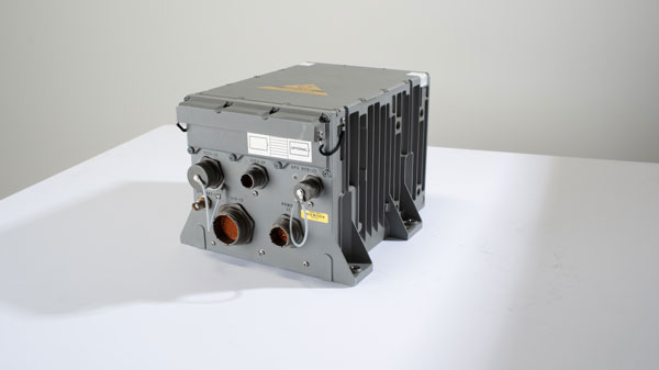
The Army tested the EGI units with enabled M-code on the MQ-1C Gray Eagle unmanned aerial system and validated it to be deployed on military aircraft. This year, the Army will begin migrating its fleet to the Honeywell EAGLE-M EGI with M-code, as this navigation solution enhances the resiliency of GPS navigation to enemy actions.
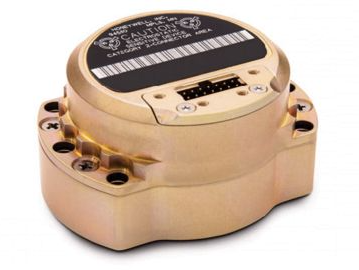
Image: Honeywell
The defense technology company has delivered more than 300 EGIs with M-code to customers and will deliver qualified units, featuring M-code GPS, to the Army. Honeywell is a leader in EGI for military applications and has provided more than 45,000 EGI units for several different types of aircraft in more than 30 countries.
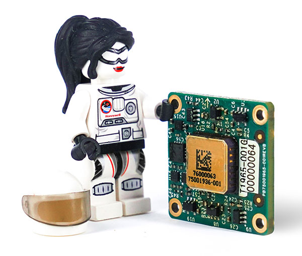
A LEGO Minifigure beside the MV60 shows its small size. (Photo: Honeywell)
Honeywell has unveiled a new accelerometer that delivers high performance and reliability in a small, rugged and low-cost package. The MV60 micro-electromechanical system (MEMS) accelerometer is designed for aerospace and defense, but also has potential uses in industrial and marine applications that require high-precision, navigation-grade accelerometers that are small, lightweight and require little power to operate.
The MV60 measures the acceleration experienced by an object during movement. These types of high-accuracy sensors are mainly used in inertial measurement units and navigation systems deployed on land, air and sea vehicles to measure velocity.
Additionally, inertial systems provide:
key orientation information for drilling operations
precision pointing and altitude determination for vehicles
platform stabilization
target location and surveying.
“The MV60 accelerometer is a technological breakthrough that leverages 50 years of Honeywell inertial sensor and MEMS experience to offer excellent reliability, ruggedness and performance,” said Matt Picchetti, vice president, Navigation and Sensors, Honeywell Aerospace. “Our customers in a wide range of markets will benefit from an accelerometer that is smaller, lighter and requires less power over similar offerings, and they won’t have to sacrifice performance.”
The highly reliable Honeywell MV60 accelerometer features a compact footprint of 1.2 square inches and has shock survivability of up to 5,000 g (g-force). It also offers bandwidth of greater than 300 Hz (hertz) — important for environmentally demanding missions.
The MV60 delivers accuracy and performance that previously had only been available in more expensive solutions. Now, customers have a more affordable, rugged, and small-scale offering suitable for the most demanding navigation applications.
Accelerometers are critical elements of navigation systems, and Honeywell provides a portfolio of precision accelerometers that deliver reliable performance at affordable prices to meet customer needs.
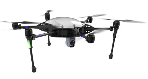
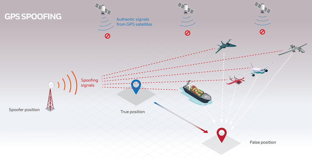
InfiniDome, Honeywell and Easy Aerial have successfully demonstrated their new Robust Navigation System for UAVs. The system integrates GPS anti-jamming technology, a radar velocity system and an inertial navigation system into a resilient system that enables UAVs to safely operate in GNSS-challenged or denied environments.
UAV developers or end users currently try to solve the problem of GNSS jamming either by creating “safe landing protocols” in GNSS-challenged environments or by adding various types of sensors such as lidar or optical. These sensors may not work in certain scenarios, such as when flying too high, too low or too fast; in fog or darkness; or above the ocean.
The Robust Navigation System, jointly developed by Honeywell and infiniDome, tightly pairs the GNSS-based UAV-tailored Honeywell Compact Inertial Navigation System (HCINS) with infiniDome’s GNSS anti-jamming technology (GPSdome), integrated with Honeywell’s Radar-based Velocity System (HRVS). It can be installed on almost any UAV, providing continuous, accurate navigation data in GNSS-challenged or fully GNSS-denied environments.
The companies demonstrated the new navigation system for Israeli defense prime contractors and drone companies and government end-users at a testing range in the center of Israel. The system was tested against two military-grade directional jammers of different types and bandwidths on customized Osprey Hexa-copter with a PixHawk 2.1 Cube Black flight controller. The GPS 1 input was a Here2 standard GNSS receiver and antenna module; the GPS 2 input was the Robust Navigation System (GPSdome 1.03 + HCINS + HRVS).
A customized Osprey Hexa-copter demonstrated the Robust Navigation System. (Photo: InfiniDome)
The goal of the demo was to show that a UAV in a GNSS-challenged environment (single direction of jamming) and fully denied environment (multiple directions of powerful jamming) can perform autonomous tasks accurately and safely without the pilot needing to assume manual control. This included beyond-visual-line-of-sight flights.
Each test was designed to be more difficult than the preceding one and would be executed only if the latter was successful. The intention was to find the barrier at which the system fails.
The first test was maintaining the UAV height (AltHold), position (PosHold) and Loiter autonomously under jamming conditions, followed by a simple point-to-point autonomous task under the same jamming conditions.
The UAV then performed a fully autonomous task including executing a 10-point polygon and returning to the same position accurately under the same jamming conditions. Finally, the UAV was tested for lift-off performance, executing the full polygon and landing under the jamming conditions.
Protected by the Robust Navigation System, the UAV passed all planned tests.
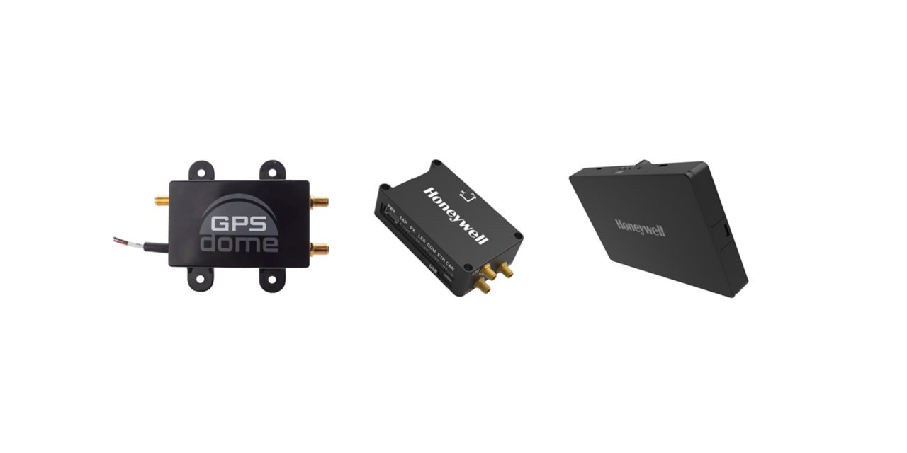
Honeywell has launched two new resilient navigation systems: the Honeywell Compact Inertial Navigation System and Honeywell Radar Velocity System. These systems, jointly with GPSdome, an anti-jamming system developed by Honeywell’s partner InfiniDome, are designed for commercial and military customers needing reliable navigation solutions that are small and light and have a low power consumption.
The systems will provide multiple layers of protection that allow continued operations even in GNSS-challenged or denied environments.
Honeywell’s philosophy of resilient navigation revolves around multiple layers of resiliency achieved by a combination of GNSS anti-jamming, inertial navigation and alternative navigation systems.
The GPSdome is a small add-on device that provides the first layer of protection against GNSS jamming attempts, ensuring continuity of operation during low-power jamming conditions and the ability to achieve the crucial first GPS lock even in GPS-challenged environments. The device is compatible with any off-the-shelf GNSS receiver and antenna. Honeywell signed a collaboration agreement with infiniDome in August to jointly develop and deliver GPS signal protection systems.
The new Honeywell Compact Inertial Navigation System is about the size of a deck of cards and uses tactical-grade inertial sensors to provide accurate position information to commercial and military customers. This second layer of resiliency provides the ability to navigate during shorter GNSS outages. This is especially useful in urban canyons where GNSS availability is intermittent or in strong jamming environments where anti-jamming systems are not enough.
A roundup of recent products in the GNSS and inertial positioning industry from the July 2021 issue of GPS World magazine.
OEM
GNSS/INS Sensors
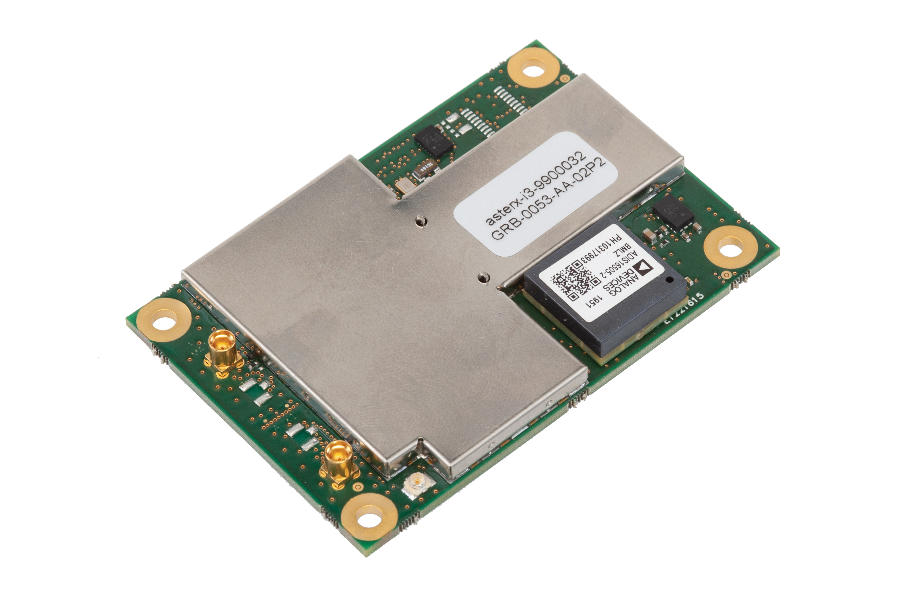
Photo: Septentrio
Five receivers in new product line
The AsteRx-i3 product family provides an array of next-generation receivers, from plug-and-play navigation solutions to feature-rich receivers with raw measurement access. Included are OEM boards and ruggedized receivers enclosed in a waterproof IP68 housing. The Pro receivers offer high accuracy positioning with 3D orientation and dead-reckoning for plug-and-play integrations. Pro+ receivers provide integrated positioning and orientation along with raw measurements, in single- or dual-antenna configurations, suitable for applications with sensor fusion. One of the receivers offers an off-board inertial measurement unit (IMU), which can be mounted exactly at the alignment point of interest.
The RES 720 GNSS dual-frequency embedded timing module provides next-generation networks with 5-nanosecond accuracy. It uses L1 and L5 GNSS signals to provide superior protection to jamming and spoofing, mitigates multipath in harsh environments, and adds security features to make it suitable for resilient networks. At 19 x 19 millimeters, the RES 720 is suitable for 5G Open Radio Access Networks (RAN)/XHaul, smart grids, data centers, industrial automation and satellite communication networks, as well as calibration services and perimeter monitoring applications.
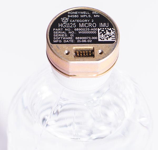
The new HG1125 and HG1126 IMUs are low-cost inertial measurement units that serve both commercial and military applications. They use sensors based on micro-electromechanical systems (MEMS) technology to precisely measure motion. They can survive shocks up to 40,000 G-force. The HG1125 and HG1126 can be used for a variety of defense and commercial applications, such as tactical military needs, drilling, unmanned aerial vehicles or navigation systems for general aviation aircraft.
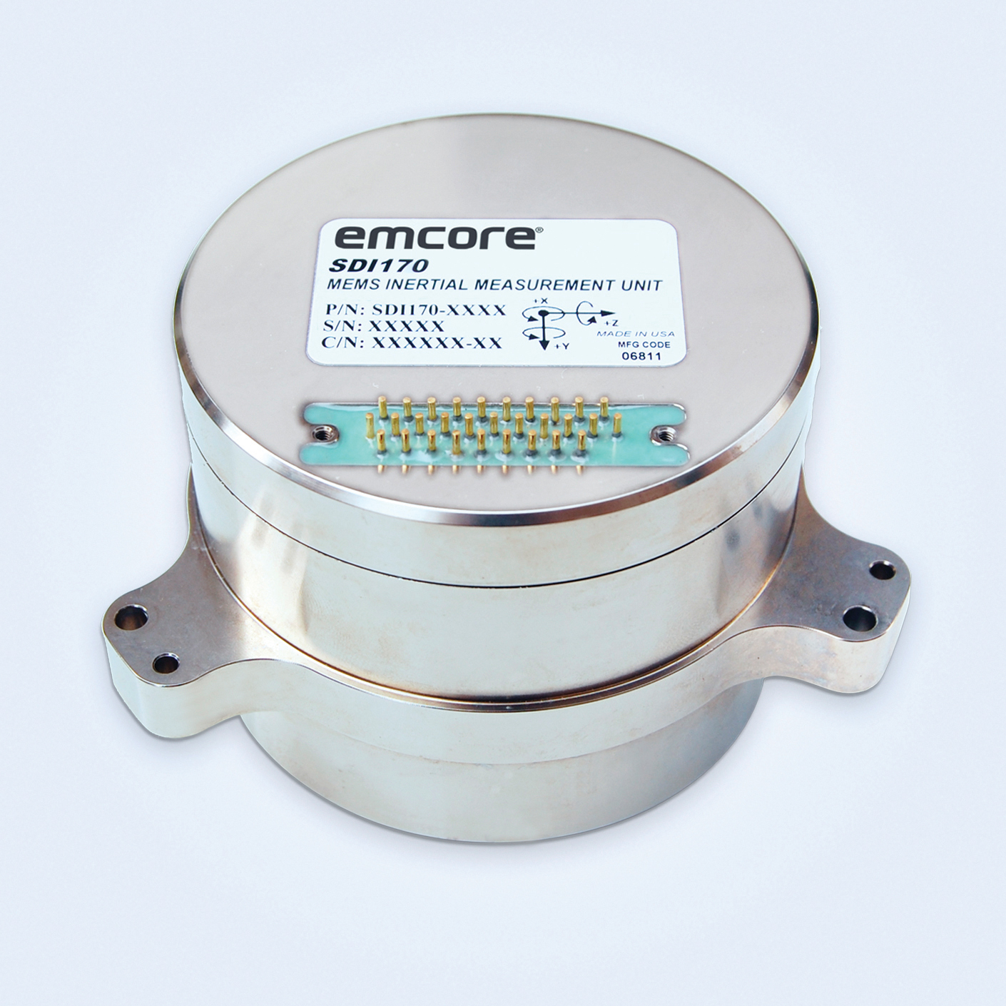
The SDI170 quartz MEMS tactical-grade IMU is designed as a form-, fit- and function-compatible replacement for the HG1700-AG58 ring-laser gyroscope (RLG) IMU, but with superior overall performance, versatility and a significantly higher mean time between failures (MTBF) rating over ruggedized environments. The SDI170 IMU delivers highly linear accelerometer performance and longer life compared to the HG1700 IMU.
The OSA 5405-MB is a compact outdoor precision time protocol (PTP) grandmaster clock with a multi-band GNSS receiver and an integrated antenna. It ensures timing accuracy by eliminating the impact of ionospheric delay variation, enabling communication service providers and enterprises to deliver the nanosecond precision needed for 5G fronthaul and other time-sensitive applications. A multi-constellation GNSS receiver and antenna enable the OSA 5405-MB to meet PRTC-B accuracy requirements (+/–40 nanoseconds) even in challenging conditions. It receives GNSS signals in two frequency bands, using the differences between them to calculate and compensate for ionospheric delay variation. The OSA 5405-MB is resilient against jamming and spoofing, considered critical for 5G synchronization. It can work with up to four GNSS constellations concurrently (GPS, Galileo, GLONASS and BeiDou).
The Toughbook S1 is a fully rugged 7-inch Android tablet for capturing and accessing critical information in the field. GPS and LTE come optionally. The tablet is supported by Productivity+, a comprehensive Android ecosystem that enables customers to develop, deploy and sustain the Android OS environment in the enterprise. The Toughbook S1 tablet’s compact, rugged and lightweight body is made for portability and reliability for field workers. It has a 14-hour battery life and warm swap battery. Features include a sleek outdoor-readable anti-reflection screen, patented rain mode and multi-touch performance whether using a stylus, finger or glove.
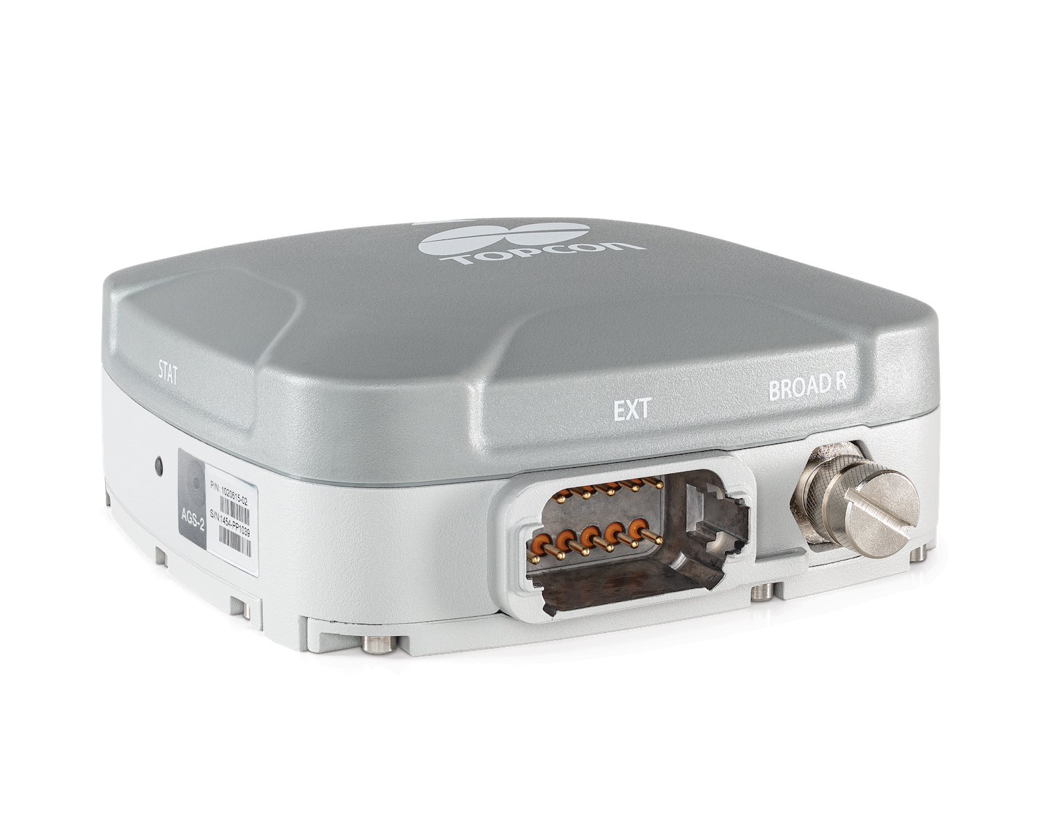
The AGS-2 and AGM-1 are manual guidance and autosteering receivers. Location data enable crop optimization, including soil preparation, seeding, crop care and harvesting. Designed to suit virtually any agricultural machine type, make and model, the AGS-2 receiver and steering controller combines steering with network reception and tracking. It comes standard with DGNSS correction services and is upgradeable using NTRIP and an optional RTK radio in the Topcon CL-55 cloud connectivity device. The AGM-1 is offered as an economical entry-level manual-guidance receiver.
Provides fast data processing for construction and surveying
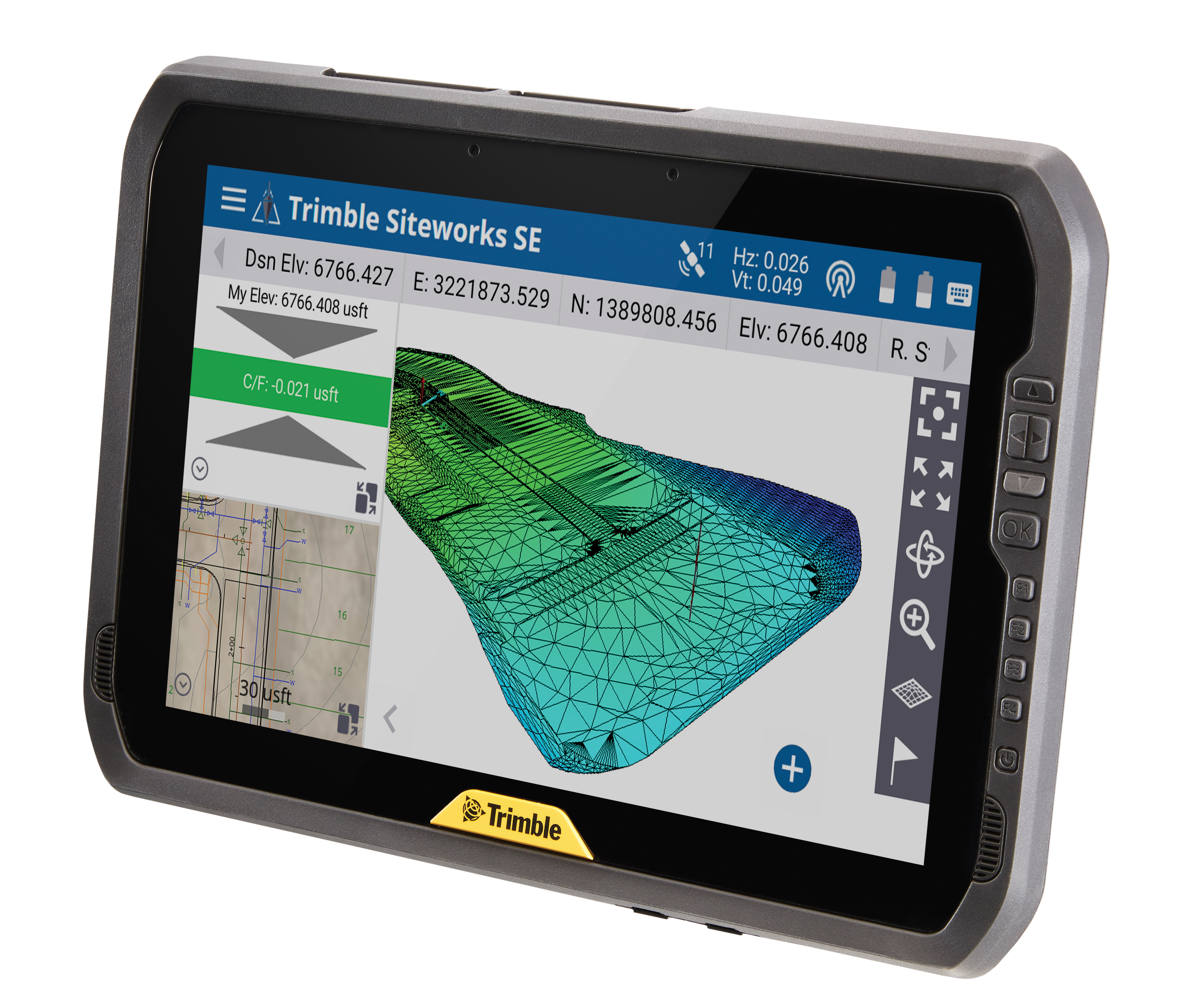
The Trimble T100 high-performance tablet is suitable for both experienced and novice users. It is optimized for Trimble Siteworks Software and supporting office applications such as Trimble Business Center. Its accessories are designed to complement user workflows, enabling users to complete quality assurance and quality control before leaving the field. The tablet is designed to be flexible and usable in a variety of configurations and job sites. It is engineered to be ergonomic and portable on and off the pole. Features include a 10-inch (25.4 cm) sunlight-readable touchscreen display, a directional keypad with programmable function keys and a 92-Wh internal battery.
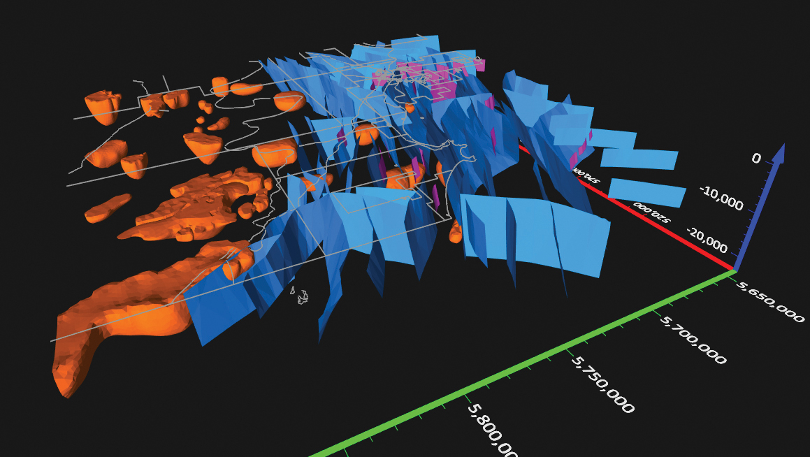
Surfer has new gridding, contouring and surface mapping software to make it easier for users to visualize, display and analyze complex 3D data. Surfer enables users to model data sets, apply an array of advanced analytics tools, and graphically communicate the results. The scientific modeling package is used in oil and gas exploration, environmental consulting, mining, engineering and geospatial projects. Enhancements have been made to 3D Base Maps, Contour Volume/Area Calculation, 3D PDF Exporting Options and automated features for creation of scripts and workflows.
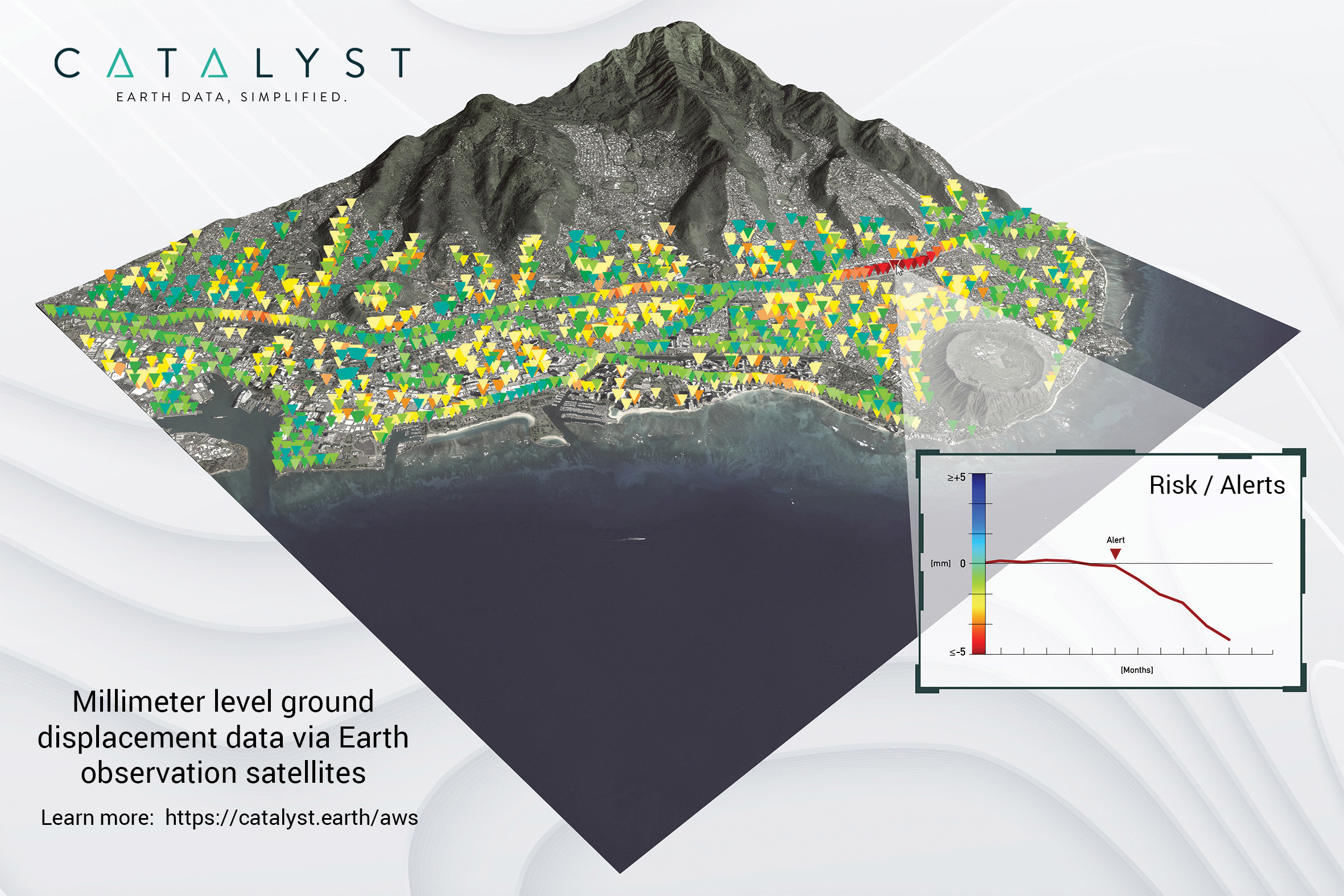
A Catalyst-AWS collaboration delivers actionable geoscience analytics to users, providing satellite-based Earth observation intelligence. The data and analytics are delivered via Amazon Web Services (AWS) Cloud. Catalyst is a PCI Geomatics brand. The initial solution, available through AWS Data Exchange, is an infrastructure risk-assessment service that uses satellite data to continuously monitor millimeter-level ground displacement over a subscriber’s area of interest anywhere on Earth. Catalyst is exploring additional risk mitigation solutions and monitoring services using AWS. Having image processing science and imagery on the cloud reduces latency and costly data transfers.
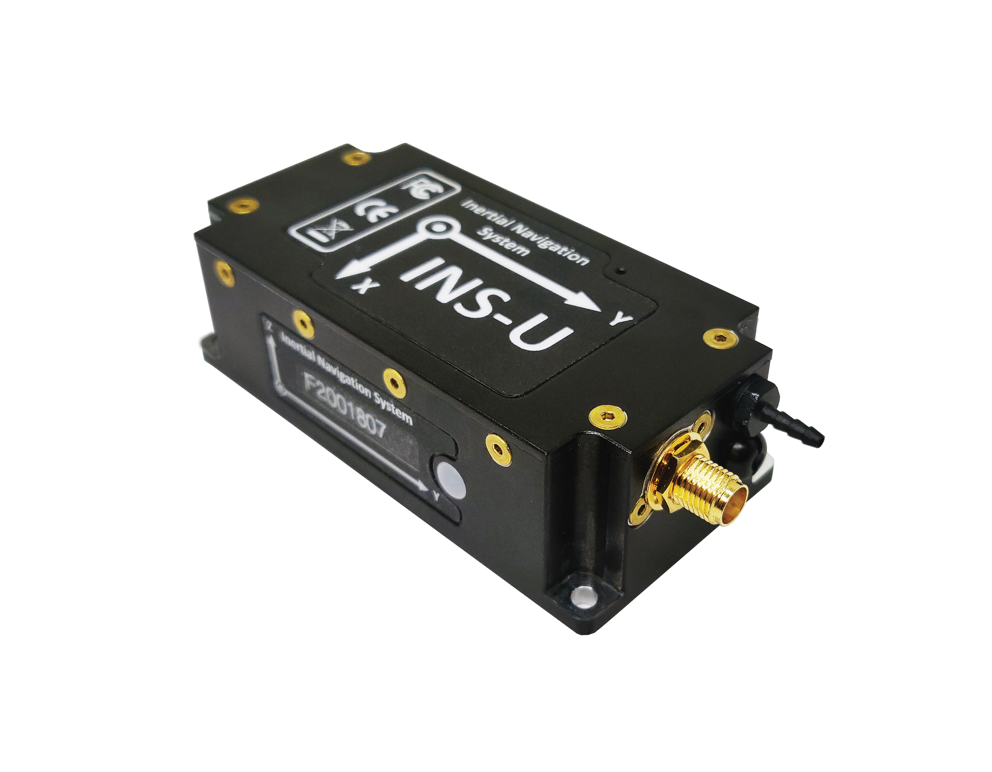
The GPS-aided INS-U is a fully integrated attitude and heading reference system (AHRS), IMU and air-data computer high-performance strapdown system that determines position, navigation and timing information for any device on which it is mounted. The INS-U uses a single antenna, multi-constellation u-blox GNSS receiver. With access to GPS, GLONASS, Galileo, QZSS and BeiDou, the INS-U can be used in a variety of GPS-enabled environments and is protected against spoofing and jamming. The INS-U has two barometers, a miniature gyro-compensated fluxgate compass, and tri-axis temperature-calibrated advanced MEMS accelerometers and gyroscopes. These high-performance sensors, along with Inertial Labs’ new on-board sensor-fusion filter, and state-of-the-art guidance and navigation algorithms, provide accurate position, velocity and orientation of the device under measurement.
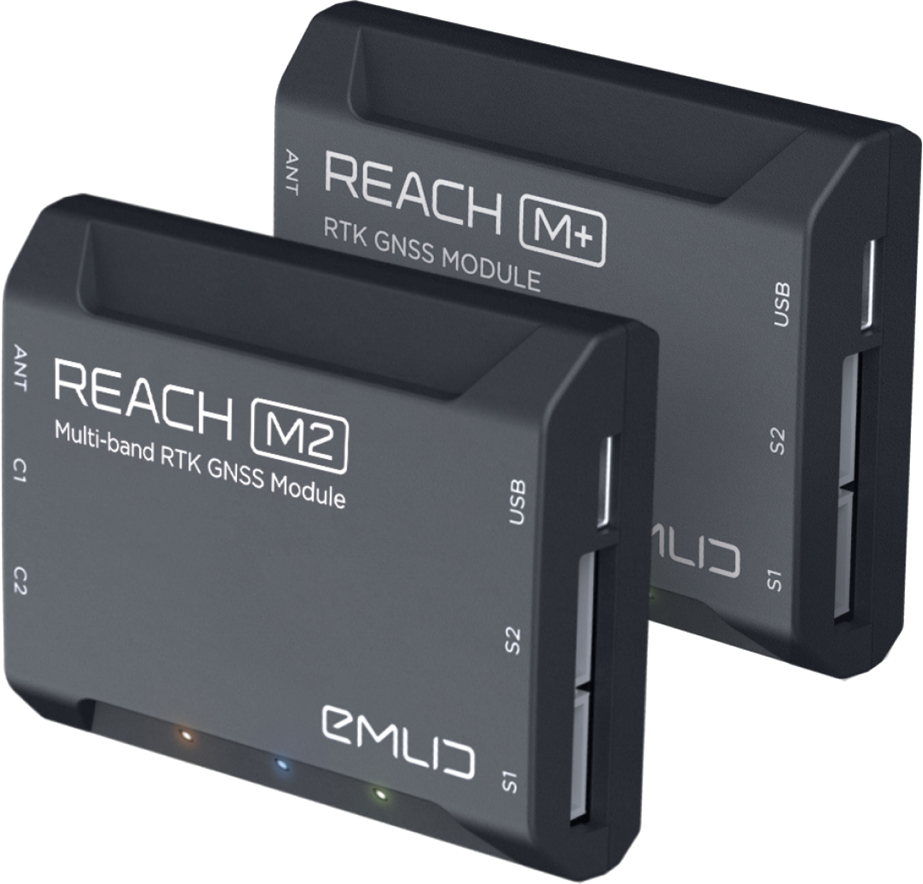
The Reach M+ and Reach M2 positioning modules for UAV mapping provide centimeter-level accuracy in real-time kinematic (RTK) and post-processed kinematic (PPK) modes, enabling precise UAV mapping with fewer ground control points. The Reach M+ single-band receiver has a baseline up to 20 kilometers in PPK. The Reach M2 is a multi-band receiver with a baseline up to 100 kilometers in PPK. Reach connects directly to a camera’s hot-shoe port and is synced with the shutter. Time and coordinates of each photo are logged with a resolution of less than a microsecond. Reach captures flash sync pulses with sub-microsecond resolution and stores them in a raw data RINEX log in the internal memory. This method allows ground control points to be used only to check accuracy.
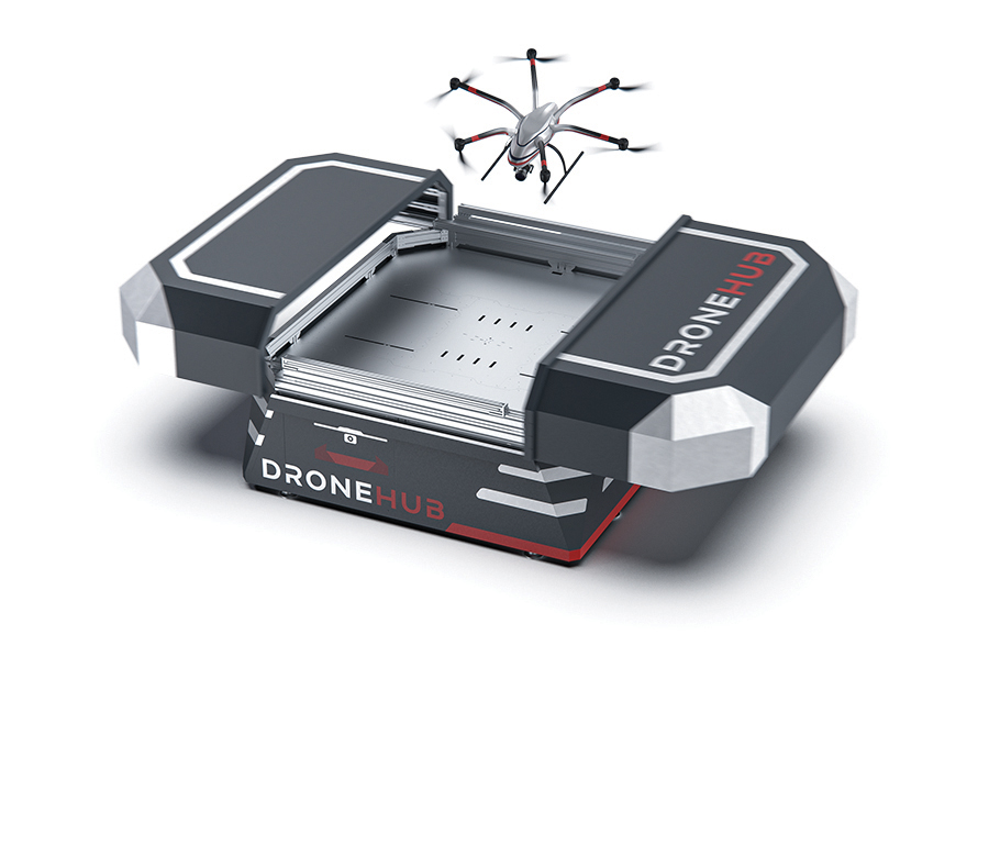
System simplifies drone inspection missions, deliveries
The Dronehub is an automated solution that can provide undisturbed drone service 24/7 in nearly any weather condition. With the integration of IBM artificial intelligence technology, Dronehub solutions can operate and automatically provide information with little human interaction. The system includes the drone and a docking station with automatic battery replacement. It can fly for 45 minutes in +/–45° C weather, up to 35 km in winds up to 15 m/s. It can carry a payload up to 5 kg as far as 15 km. It can be used for monitoring, inspection and measurement; cargo transport and parcel deliveries; and mobile ground infrastructure; and security.
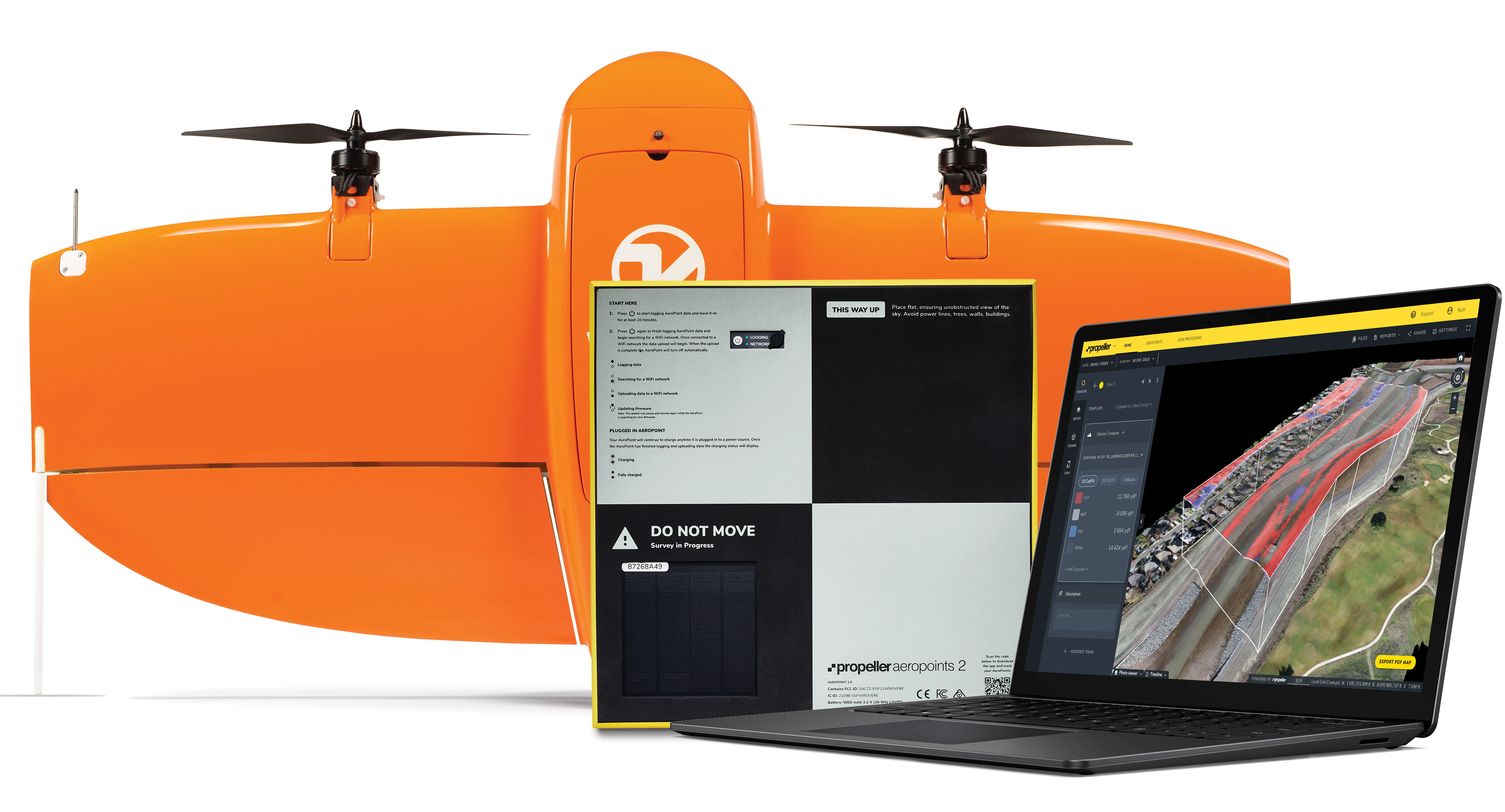
The Propeller Platform and WingtraOne drone package enable construction professionals to collect survey-grade data across the worksite consistently and accurately. To operate, surveyors place Propeller AeroPoints (smart ground-control points) on their worksite, and then fly the WingtraOne drone to collect worksite survey data. Survey images are uploaded to Propeller’s cloud-based platform, where the fully automated geotagging and photogrammetry processing is completed within 24 hours of submission on the platform. Uses include mines, road and railway projects, highways and industrial complexes. Data collection with AeroPoints and Propeller PPK can serve as a reliable, single source for survey data and progress. Teams across the entire worksite can view geographically accurate and realistic 3D site models and track, inspect and report on job progress and productivity safely and accurately.
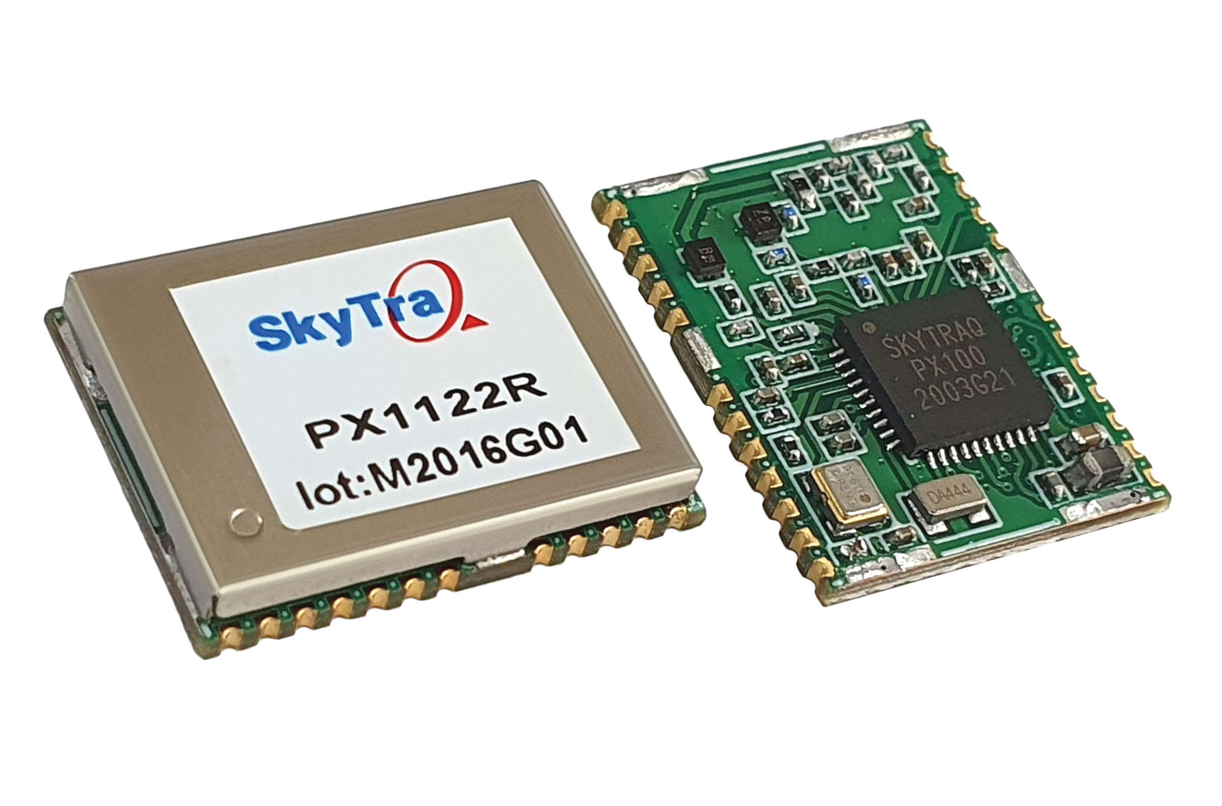
Stamp-sized module provides RTK positioning and heading
The PX1122R is a high-performance multi-band quad-GNSS real-time kinematic (RTK) receiver featuring 1 cm + 1 ppm position accuracy and under 10-second RTK convergence. It has a 12 x 16 millimeter form factor, about the size of a postage stamp. It can be configured for a base or a rover, and supports a moving base RTK for precision heading applications. The PX1122R has a maximum quad-GNSS RTK update rate of 10 Hz, providing a quick response time and more stable performance for fast-moving precision guidance applications.
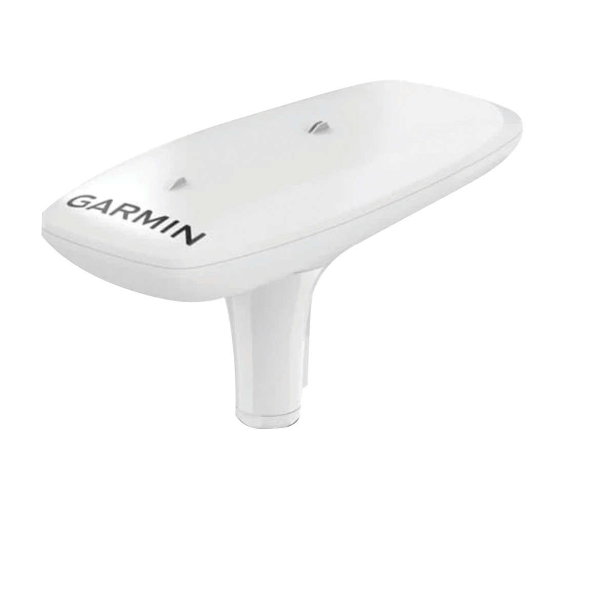
Utilizing both L1 and L5 GPS frequencies, along with multi-constellation support (GPS, Galileo, GLONASS and BeiDou), the MSC 10 marine satellite compass provides precise positioning and heading accuracy within 2 degrees. Its 10-Hz position update rate delivers detailed tracking information. It eliminates magnetic interference, which can degrade heading accuracy. The MSC 10 is easy to install and can be used as the primary position and heading sensor across multiple systems, including autopilots. If the satellite signal is lost, it will transition from GPS-based to a backup magnetometer-based heading.
As illustrated here, the new HG1125 IMU is about the size of a water-bottle cap. (Photo: Honeywell)
Honeywell has launched a new series of miniature inertial measurement units (IMUs) ruggedized to offer high accuracy along with the durability to survive high-shock environments.
Roughly the size of a water-bottle cap, the new HG1125 and HG1126 IMUs are low cost and serve both commercial and military applications.
The new family of IMUs can survive shocks up to 40,000 G-force, making it one of Honeywell’s toughest IMU products to date. The HG1125 and HG1126 can be used for a variety of defense and commercial applications such as tactical military needs, drilling, unmanned aerial vehicles or navigation systems for general aviation aircraft.
“Low-cost, ultra-rugged IMUs are in high demand across a variety of market segments where customers need high-performance navigation, but they’re limited by size or cost constraints,” said Matt Picchetti, vice president and general manager, Navigation & Sensors, Honeywell Aerospace. “Our new HG1125 and HG1126 products meet all of these requirements, making them an ideal solution for customers operating in a wide variety of high-shock environments, including everything from military tactical operations to industrial applications such as drilling.”
An IMU uses gyroscopes, accelerometers and electronics to give precise rotation and acceleration data. This enables a vehicle system to calculate where it is, in what direction it is going, and at what speed, even when GPS signals are not available.
The HG1125 and HG1126 use sensors based on micro-electromechanical systems (MEMS) technology to precisely measure motion. They are the newest IMUs from Honeywell’s tactical IMU production facility, which delivers nearly 100,000 IMUs each year to customers across a wide range of segments.
The first deliveries of these new products are set to begin in June.
Honeywell’s lineage in navigation dates to the 1920s, and it has long been a pioneer in MEMS-based IMUs. Honeywell has developed and manufactured high-performance navigation solutions found on many aircraft and other vehicles worldwide.
New technologies use a variety of inputs to help ensure seamless navigation, even when GPS reception fails because of interference or jamming.
Honeywell has successfully demonstrated multiple alternate navigation technologies for military aircraft. These new products are intended to help ensure seamless navigation — even when GPS signals are blocked, interrupted or unavailable.
For military operations, GPS-jamming — intentional or not — can block vital signals from conveying critical information regarding positioning, navigation and timing (PNT). In these instances, it’s important for military vehicles and aircraft to be equipped with alternative navigation technologies, like celestial or vision navigation, to maintain operational readiness.
“For military operations, not having access to critical positioning and timing information can make or break a mission,” said Matt Picchetti, vice president and general manager, Navigation & Sensors, Honeywell Aerospace. “We’re very excited to roll out this robust lineup of alternate navigation solutions, which are specifically designed to address the needs of our military customers and give them the added layers of redundancy needed to successfully carry out their operations, even if they lose access to GPS signals.”
Illustration: Honeywell
Alternate navigation technologies provide a different means of measuring position, velocity and heading when GPS is disrupted. These technologies include:
Vision-aided navigation. This technology uses a live optical or infrared camera feed and compares it with maps to provide a passive, not jammable, highly accurate alternative PNT solution that provides GPS-like accuracy in GPS-denied or jammed conditions.
Celestial-aided navigation. Honeywell’s celestial-aided navigation technology observes stars and “reference objects” orbiting the earth such as satellites, which have known positions and velocities. This technology compares those reference objects to stars and can determine position and velocity, the same way a GPS receiver can.
Magnetic anomaly-aided navigation. This navigation technology measures magnetic strength using sensors and compares this data with known geographical magnetic maps to accurately identify the position of the aircraft relative to the Earth.
Prototypes of these alternate navigation systems will be available in 2022, with initial deliveries expected to start in 2023.
Honeywell navigation systems are used by nearly every aircraft flying to guide millions of passengers to their destinations. Since 1914 when the first autopilot used Honeywell gyroscopes to hold the plane stable during flight, Honeywell has delivered more than 500,000 high-performance inertial sensors across several platforms on land, in the air and at sea.
Findings show accuracy of new sensors is improved by greater than an order of magnitude over current offerings.
Honeywell, with funding from the U.S. Defense Advanced Research Projects Agency (DARPA), is creating the next generation of inertial sensor technology that will one day be used in both commercial and defense navigation applications.
The HG1930 IMU. (Photo: Honeywell)
Findings gathered in Honeywell labs have shown the new sensors to be greater than an order of magnitude more accurate than Honeywell’s HG1930 inertial measurement unit (IMU) product, a tactical-grade product with more than 150,000 units currently in use.
An IMU uses gyroscopes, accelerometers and electronics to give precise rotation and acceleration data to enable a vehicle system to calculate where it is, what direction it is going and at what speed, even when GPS signals aren’t available.
There are various types of IMUs on the market, and some — like the next-generation version currently under development — use sensors based on micro-electromechanical systems (MEMS) technology to precisely measure motion.
“Typically, MEMS inertial sensors have been on the lower end of the performance scale, but this latest milestone shows we are changing that paradigm,” said Jenni Strabley, director of offering management for Inertial Sensors, Honeywell Aerospace. “With this next-generation MEMS technology, we’re increasing performance without having to significantly change the size or weight of the IMU. This is a game-changer for the navigation industry, where customers need highly accurate solutions but cannot afford to compromise on weight or size.”
Over the past few years, Honeywell has been working with DARPA to develop the next generation of high-precision navigation-grade IMU technology, under the Precise Robust Inertial Guidance for Munitions: Thermally Stabilized Inertial Guidance for Munitions program.
The new MEMS sensors will use different sensor designs and electronics to enable higher performance. They will serve a broad range of applications in autonomous land and air vehicles for both military and commercial customers, including future urban air mobility aircraft.
“Now that we have demonstrated that MEMS is capable of reaching these incredibly precise performance levels, it is the perfect time to start talking with potential users about how this technology could help their applications,” Strabley said. “We believe this new technology will have a variety of applications, such as onboard future vehicles that will fly in urban environments where lightweight, extremely precise navigation is critical to safer operations. Additionally, there are other applications that haven’t been invented yet but may be enabled by these types of technology innovations.”
Commercial sales of an IMU containing these next-generation sensors are still several years away, but one of the first products using this new technology is expected to be more than 50 times more accurate while roughly the same size as Honeywell’s IMU.
Honeywell has long been a pioneer in MEMS-based IMUs, including the HG1930. Honeywell’s lineage in navigation dates to the 1920s and since then Honeywell has developed and manufactured high-performance navigation solutions found on many aircraft and other vehicles worldwide.
Latest inertial navigation system serves new customer requirements in autonomous vehicles, mobile mapping, surveying and more
Photo: Honeywell
Honeywell is introducing the HGuide n380, an inertial navigation system (INS) that communicates position, orientation and velocity of an object — such as an autonomous vehicle or unmanned aerial vehicle (UAV) — even when global navigation satellite signals are unavailable.
Smaller, lighter and lower priced than previous Honeywell inertial navigation systems, the HGuide n380 is built using Honeywell’s rigorous design standards to withstand harsh environments in the air, on land or at sea.
“We recognized a need for a small, high-performance inertial navigation system in areas like 3D mapping, surveying and other applications where space is at a premium and performance cannot be compromised,” said Chris Lund, offering management senior director, Navigation and Sensors, Honeywell Aerospace. “We responded by developing the HGuide n380 inertial navigation system, which provides our customers with proven, cost effective inertial sensor technology, created for aerospace applications, but that can be integrated into almost any architecture.”
The new inertial navigation system is composed of Honeywell’s HGuide i300 inertial measurement unit (IMU), a GNSS receiver and Honeywell’s proprietary sensor-fusion software, which is based on the algorithms used for navigation on millions of aircraft every day.
Inputs from these components are fused together to determine position, orientation and velocity to deliver critical navigation information even in areas where a satellite signal is degraded or altogether unavailable, such as canyons, bridges, tunnels, mountains, parking garages or dense forests.
“As the industry evolves, Honeywell’s HGuide suite of IMUs and navigators will be a key enabler of emerging segments like autonomous vehicles, mobile mapping, precision agriculture, robotics and surveying,” Lund said.
During its development, the new product was placed in extreme environments to test ruggedness and was exposed to extensive factory calibration and compensation procedures that help ensure measurement accuracy and performance.
Honeywell has extensive experience in designing and building high-end inertial sensor and navigation systems and has used that expertise to develop a lower-cost portfolio of HGuide offerings to serve new markets and customer requirements.
To date, Honeywell has delivered more than half a million high-performance inertial sensors to serve as navigation aids on an extensive list of manned and unmanned vehicles, which include many air and spacecraft in use today.
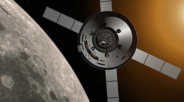
Honeywell, under a contract with Lockheed Martin, will supply guidance and navigation systems for NASA’s upcoming Artemis missions, which will fly humans to the moon for the first time since 1972.
The companies are supplying key components to NASA’s Orion spacecraft fleet for the Artemis missions. Components include the barometric altimeter, the inertial measurement system, and the GPS receiver.
Honeywell will provide 14 product types for Artemis missions III through V, including both hardware and software solutions, to support NASA’s lunar missions. NASA awarded Lockheed Martin a long-term, multibillion-dollar production contract for the Orion spacecraft, aimed to meet the space agency’s anticipated needs into the 2030s.
Working in collaboration with the Orion team over the next decade, Honeywell will support Lockheed Martin and its partners through the development and production of essential guidance and navigation systems, command data handling, and display and control products. The focus of the missions is to conduct science and learn lessons that will help take humans to Mars.
Honeywell will supply the following types of technology for the Artemis missions:
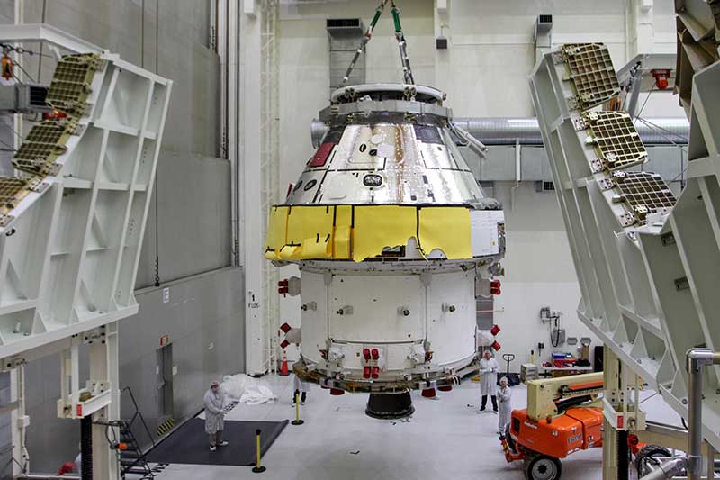
First Orion Spacecraft: In this March 30 photo, Orion I is moved to the Final Assembly and Systems Test cell at Kennedy Space Center. The spacecraft returned from Ohio after a successful series of environmental tests at Glenn Research Center’s Plum Brook Station. (Photo: NASA)
• Guidance and Navigation Systems. Key navigation and guidance solutions, including the barometric altimeter, which tracks the altitude of the Orion capsule in Earth’s atmosphere, as well as the inertial measurement system (INS) and GPS receiver, which track the position and movements of the capsule.
• Command Data Handling. Several data-handling products, including the vehicle management computer, which acts as the central computing platform supporting flight and vehicle control, as well as spacecraft communication functions.
• Displays and Controls. Three display units and struts, seven control panels, and two hand controllers used inside the spacecraft to help astronauts in the Orion capsule monitor and control the vehicle.
• Core Flight Software. Includes the integrated modular avionics software, a key system responsible for supporting maintenance functions sharing flight data information.
The contract to supply key components of the Orion crew module and service module is being managed and performed out of Honeywell’s facility in Clearwater, Florida. Work is also being conducted at the company’s facilities in Glendale, Arizona, and Puerto Rico.
Honeywell was part of NASA’s previous crewed space missions, including those that took humans to the moon.
Honeywell has been granted a four-year, $99 million contract to help the U.S. Air Force for the embedded GPS and inertial navigation systems (INS) modernization program (EGI-M). Honeywell will provide engineering, manufacturing and development services to the EGI-M program under the sole-source contract, according to the Department of Defense.
Work will be performed in Clearwater, Florida, through April 19, 2024.
The contract is the result of a sole-source acquisition and only one offer was received. The Air Force Life Cycle Management Center, Position, Navigation & Timing Contracting Branch, Robins Air Force Base, Georgia, is the contracting activity (FA8576-20-C-0001).