Honeywell has launched Kestrel, a compact navigation solution designed to help uncrewed aerial systems (UAS) operate reliably in contested environments where GPS signals may be degraded, jammed or spoofed.
Built to support the growing demand for smaller, more affordable and highly efficient platforms, Kestrel combines Honeywell Aerospace’s HG3900 MEMS inertial measurement unit with an M-code receiver and a multi-GNSS receiver. The platform is intended to meet the specific needs of Group 2 and 3 collaborative combat aircraft and loitering munitions platforms. It is also suitable for crewed aircraft where size, weight, power and cost are important considerations.
“Kestrel reflects the evolving needs of today’s uncrewed operations, where operators are looking for resilient navigation technology that is smaller, lighter and more cost-effective,” said Matt Picchetti, vice president and general manager of Navigation & Sensors at Honeywell Aerospace. “This system helps operators maintain mission objectives in environments where legacy GPS systems are lagging behind.”
Kestrel is an Embedded GNSS/INS (EGI) system for global defense and commercial operators in need of advanced inertial navigation technology with secure positioning capabilities in a smaller footprint. The system is 40 percent smaller and lighter than similar navigation products while delivering up to an 80 percent improvement in navigation accuracy for uncrewed platforms. It also reduces costs by as much as 50 percent, helping operators efficiently scale deployment across high-volume drone operations. Kestrel’s resiliency reduces UAS attrition by 60 percent, while more than doubling the capacity for mission distances.
The ability to operate without assured GNSS access is a distinct advantage for any military aircraft operating in contested or GNSS-denied environments because it provides continuous, self-contained position, velocity and attitude estimates independent of external signals.
Kestrel is designed to support a broad range of defense and commercial applications and will be available in configurations that support international and non-ITAR deployments.
Honeywell pioneered EGI technology and has produced more than 60,000 units since the mid-1990s to meet customers’ most challenging navigation, pointing, stabilization and flight-control applications.
FastXY can transform standard mobile devices into professional-grade data collection tools for geospatial information systems (GIS) and architecture, engineering and construction (AEC) professionals. FastXY offers professionals the ability to collect point, line and polygon data, and delivers advanced capabilities including 3D basemaps, construction staking, topographic surveying, on-the-fly datum transformations and survey-grade elevations. A built-in Bluetooth data parser allows users to configure the app to collect data from virtually any instrument supporting BLE Bluetooth or RS-232 — including echosounders, radiation sensors, laser rangefinders, barcode scanners and more — and marry that data instantly with precise GNSS coordinates. Available in free and premium versions.
Handheld scanner: Designed for BIM, indoor scanning and reality capture
The RS7 handheld SLAM (simultaneous localization and mapping) scanning solution was built for BIM documentation, indoor surveying, renovation planning and complex spatial analysis. It is designed to help professionals capture high-density 3D data efficiently and convert it into practical deliverables through CHCNAV’s software and cloud ecosystem. The RS7 integrates a next-generation lidar scanner capable of measuring up to 1.15 million points per second. Its wide field of view (360° x 189°) supports comprehensive coverage of floors, walls and ceilings, helping reduce the need for repeated passes and complex capture maneuvers in tight or cluttered spaces. The scanner also includes a high-precision inertial measurement unit with bias stability better than 0.5°/h. By combining lidar and inertial data, the system is designed to maintain stable motion estimation and consistent point-cloud quality in environments that challenge many mobile workflows, including long corridors, repetitive structures, and feature-limited interiors.
Mobile scanner: All-in-one system offers SLAM, LIDAR, RTK and 360 degree imagery
The GX1 is an integrated, highly accurate all-in-one mobile scanning system combining simultaneous localization and mapping (SLAM), lidar, real-time kinematic (RTK) georeferencing, cameras and software. It supports a seamless workflow, from capture to deliverable, and can reduce the time required to survey a site by up to 95%. The independently validated global accuracy of 5 mm to 10 mm delivers the precision needed for topographic and road surveying, scan to building information models, construction progress tracking, and more. These capabilities are supported by integrated RTK georeferencing with real-time quality monitoring, four 20MP cameras for 360° panoramic imagery, and a proven SLAM algorithm. The GX1 has four deployment modes — backpack, survey pole, vehicle mount and supported handheld.
Quad-band GNSS rover: With support for Galileo high accuracy service
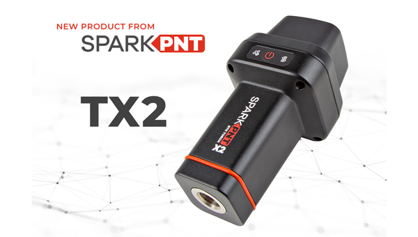
The SparkPNT TX2 quad-band GNSS rover combines an IP67-rated aluminum enclosure with support for Galileo’s High Accuracy Service (HAS) and standard RTK correction workflows. The receiver is built around the Quectel LG290P quad-band GNSS engine and supports multi-constellation tracking. Galileo HAS support provides sub-20 cm accuracy globally without subscription-based correction services, while RTK workflows via NTRIP or u-blox PointPerfect can achieve centimeter-level positioning. Battery life is rated at 50-plus hours, positioning the TX2 for multi-day field campaigns without recharging. The unit connects to iOS and Android devices via Bluetooth and WiFi, with compatibility reported for common GIS and data-collection applications. A notable design choice is the open-source firmware, which gives users visibility into how positioning data is processed and allows for customization and third-party integration. SparkFun has positioned this as an alternative to closed GNSS ecosystems where firmware and processing pipelines are not user-accessible.
Mobile
GNSS platform: Provides ultra-low power GNSS for all environments
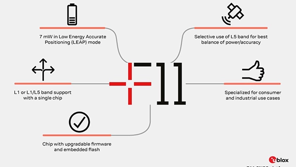
The u-blox F11 platform provides L1/L5 dual-band standardprecision GNSS to improve positioning accuracy while reducing power consumption to as low as 7 mW in typical configurations. It combines ultra-low power operation with intelligent signal management to meet the evolving demands of tracking, wearables, telematics and mobility applications — including micromobility solutions and drones. The platform enables device manufacturers to achieve longer battery life, faster and more reliable position fixes, and greater design flexibility. Its situationally aware GNSS architecture, with integrated geofencing and indoor detections, dynamically balance accuracy and power consumption. By selectively using dual band L1/L5 operation only when it helps maintain positioning performance, the platform reduces energy use while providing resilience and maintaining confidence in location data.
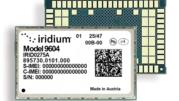
The Iridium 9604 is a compact, threein-one internet of things (IoT) module that integrates Iridium short burst data satellite service, LTE-M cellular connectivity, and GNSS positioning into a single platform. The Iridium 9604 seeks to make dual-mode IoT connectivity viable for price-sensitive, high-volume deployments. Built on the u blox SARA-R5 platform, the module comes in a compact 16 mm x 26 mm x 2.4 mm form factor, suitable for dual-mode IoT deployments across industrial, infrastructure and mobility applications.
L1+L5 GNSS modules: For trackers and high-precision IOT
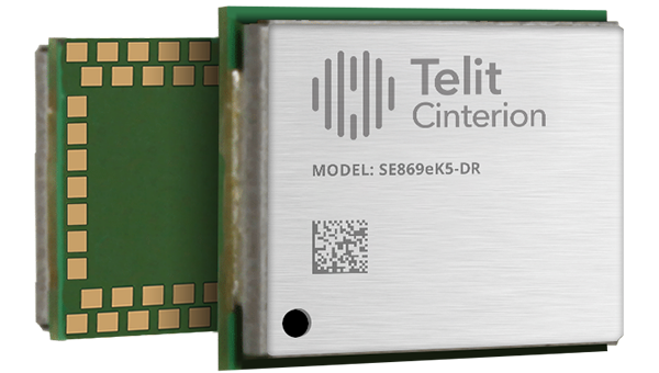
Two dual-band positioning modules built on Airoha’s AG3335 chipset series are available: the ultracompact SE873K5-D and the high-end SE869eK5-DRK. Both support space- and power-constrained IOT devices and use cases that require continuous, ultraprecise positioning. The modules provide a scalable path to adopt dual-band L1 + L5 GNSS.
Timing
Cesium-less clock: An alternative to cesium-accuracy holdover clocks
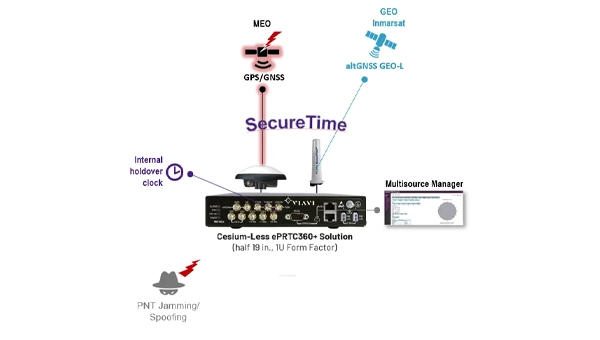
The patent-pending Cesium-less ePRTC360+ holdover solution is designed to safeguard atrisk infrastructure against the increased threat of GNSS timing disruptions. It is the only alternative to Cesium clocks to meet ITU-T G.8272.1 standards. It can protect critical power grids; transportation, aviation and public safety systems; 5G mobile networks; and AI data centers. It meets the international ITU-T G.8272.1 standard and has been successfully tested across a range of livesky defense and commercial jamming/spoofing environments. It has been integrated into VIAVI’s SecurePNT 6200 product series and can maintain 100 ns accuracy during GNSS-denied threats through the resilient altGNSS GEO-L service with no time limit.
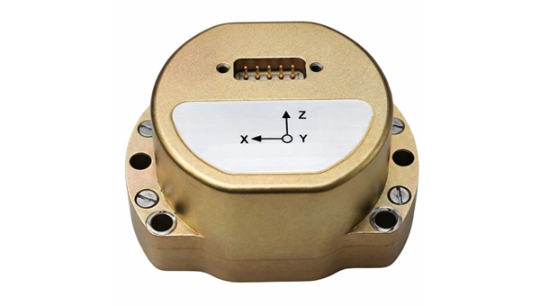
The U4930 series is a reliable and cost-effective six-axis microelectromechanical system (MEMS) and inertial measurement unit (IMU) module for navigation, control and measurement of vehicles, ships and drones. Applications include vehicle/ship attitude measurement, UAV attitude reference and trajectory control, mobile mapping, track inspection and underwater highprecision navigation. The U4930 series integrates high-performance MEMS gyroscopes and accelerometers within an independent structure. The three-axis MEMS gyroscopes sense the angular motion of the carrier, and the three-axis MEMS accelerometers sense the linear acceleration of the carrier. The system internally performs compensation for zero bias, scale factor, non-orthogonal error and acceleration-related terms across all temperature parameters, maintaining high measurement accuracy over a long period of time. The module supports custom communication protocols and provides synchronization for GPS/GNSS time data and pulse per second (PPS) signals.
Underground navigation: For navigating mines and unmapped environments
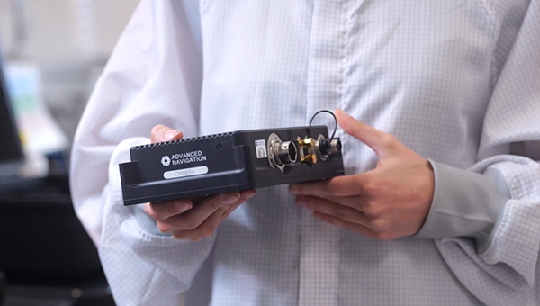
Chimera Land is a 3D laser velocity sensor (LVS) designed to solve the primary challenge for underground mining: maintaining precise vehicle positioning in deep, dark and unmapped environments where GPS cannot reach. When fused with an Advanced Navigation inertial navigation system (INS), Chimera Land allows underground vehicles to maintain stable navigation over extended distances and time. Instead of needing to query an external beacon or satellite for its location, the sensor uses specialized lasers to measure a vehicle’s ground-relative 3D velocity with high accuracy. By feeding this precise data into the vehicle’s INS, the sensor eliminates the drift that typically comes with standalone INS. Using AdNav Intelligence, the result is a resilient, high-performance, infrastructure-light positioning solution that excels in the highdust, zero-light conditions typical of underground mines.
Simulators
GNSS test tool: Provides real-world testing with signals from the field
The SimXTRACT GNSS test tool bridges the gap between field and laboratory. It enables signals captured in field environments to be comprehensively decomposed into individual, discrete signals and applied to lab simulation for realism at every stage of the development test cycle. Developers usually rely on either RF record-and-playback or lab simulation for testing and validation of PNT systems and devices. SimXTRACT takes real signals captured in field environments and performs complex signal decomposition, breaking down each received signal into discrete line-of-sight and multipath ray paths, along with metadata such as Doppler offset, code error, power level and angle of arrival. This decomposed environment is then automatically converted into fully controllable simulation scenarios for Spirent GNSS simulators.
Autonomous
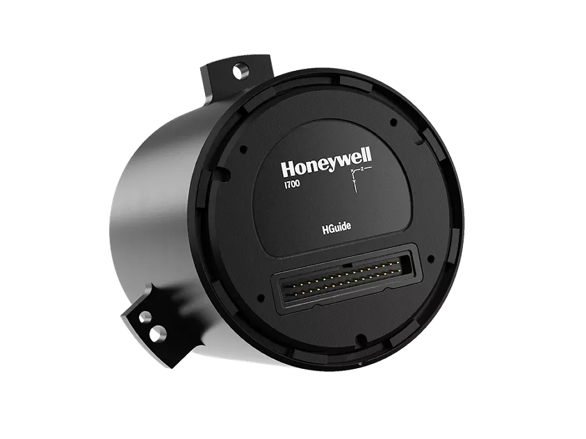
Inertial measurement unit: For unmanned air, land and sea
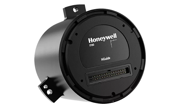
Honeywell launched the HGuide i700, an inertial measurement unit (IMU) that delivers high-accuracy performance for unmanned air, land and sea vehicles. By pairing near navigation-grade capability with a nolicense-required (NLR) classification, the HGuide i700 provides integrators worldwide with a new option for critical sensing and navigation. The HGuide i700 uses high reliability sensors and electronic architecture found in Honeywell’s HG3900 inertial measurement unit (IMU). Compact and low power, the HGuide i700 delivers near-navigationgrade accuracy and reliability while being optimized to support longer range navigation in GNSS-denied environments. The HGuide i700 offers strong GNSS-denied performance for by limiting maximum acceleration and spin rates in a license-free package. The latest in Honeywell’s HGuide suite of no-license inertial solutions, the HGuide i700 allows customers to streamline development cycles, simplify system architecture and transition to field deployment quickly. The HGuide i700’s rugged design, compact size and low-power profile make it suitable for diverse commercial, industrial and defense applications, including autonomous vehicles, mapping and surveying.
Anti-jam antenna system: Provides multi-constellation, multi-frequency GNSS signal protection
The GAJT-AE3 protects all major GNSS constellations from jamming with full multiconstellation, multi-frequency coverage, ensuring reliable PNT in demanding airborne environments. Its antenna electronics mitigate interference by creating up to seven nulls per band in the direction of jammers, providing significant anti-jam protection even in dynamic multi-jammer scenarios. The output is a protected radio frequency signal, free from jamming and suitable for input to modern and legacy GNSS receivers. The GAJT-AE3 protects and supports all GNSS frequencies, including L-band corrections and Iridium PNT.
OEM
GNSS board: All-band multifrequency reception and HAS-ready
Syslogic’s new all-band GNSS expansion board for rugged embedded computers is powered by the u-blox X20 receiver. It supports all major GNSS constellations and frequencies, including L1, L2, L5, L6 and L-band, and enables the use of the Galileo High Accuracy Service (HAS). It provides centimeter-level positioning, opening up new applications across industries such as autonomous field management, operation of construction machinery in remote areas, or navigation of automated guided vehicles and autonomous mobile robots. The GNSS board is designed for worldwide use. The integrated u-blox receiver supports modern correction techniques such as RTK, PPP-RTK and PPP. For the first time, it has been fully optimized for PointPerfect Global, u-blox’s proprietary high-precision GNSS correction service, delivering centimeter-level positioning anywhere in the world. This is particularly useful in remote areas without cellular coverage.
GNSS L1/L5 breakout: For meter-level positioning in embedded applications
The SparkFun GNSS L1/L5 Breakout – NEO-F10N (SMA) is a compact GNSS module designed for meter-level positioning accuracy in embedded applications. It uses dual-frequency L1 and L5 bands, with the L5 signal offering improved performance in urban environments due to reduced RF interference within the protected ARNS spectrum.
The board supports concurrent reception of GPS, Galileo and BeiDou, and uses u blox dual-band multipath mitigation to enhance accuracy in challenging conditions. It features a single UART interface, with an onboard CH340 USB-to-serial converter for easy connection to a computer, and standard pin headers for integration with external systems.
The module includes an SMA connector for secure antenna attachment and is configurable using u-blox u-center software.
Honeywell has launched the HGuide i700, an inertial measurement unit (IMU) that delivers high-accuracy performance for unmanned air, land and sea vehicles. By pairing near navigation-grade capability with a no-license-required (NLR) classification, the HGuide i700 provides integrators worldwide with a powerful new option for critical sensing and navigation.
The HGuide i700 uses high reliability sensors and electronic architecture found in Honeywell’s HG3900 inertial measurement unit (IMU). Compact and low power, the HGuide i700 delivers near-navigation-grade accuracy and reliability while being optimized to support longer range navigation in GNSS-denied environments
“As customers explore new autonomous, robotic and precision-guided solutions, they want the accuracy and reliability of inertial systems that can be tailored to their program requirements,” said Matt Picchetti, vice president and general manager, Navigation and Sensors, Honeywell Aerospace. “The HGuide i700 offers strong GNSS-denied performance for by limiting maximum acceleration and spin rates in a license-free package that simplifies the complexity of system development while preserving reliability.”
The latest in Honeywell’s HGuide suite of no-license inertial solutions, the HGuide i700 allows customers to streamline development cycles, simplify system architecture and transition to field deployment more quickly than existing technology.
The HGuide i700’s rugged design, compact size and low-power profile make it suitable for diverse commercial, industrial and defense applications, such as:
Unmanned aerial, land or sea vehicles
Mobile mapping and surveying systems
Long duration unmanned ground or surface platforms
Robotics and industrial automation
Stabilized payloads and pointing systems
Honeywell has been a top innovator in IMU technology for more than three decades and pioneered the use of MEMS technologies in navigation. For more information about the Honeywell HGuide i700 and Honeywell’s navigation solutions, visit Honeywell Aerospace.
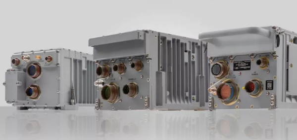
Honeywell has received U.S. government authorization for the remaining variants of its M-code GPS Inertial Navigation System (EGI), which will help enable more secure and precise navigation for military aircraft worldwide.
Honeywell was awarded the MSO-c145b authorization by the Precise Position Equipment Certification Office (PECO) for its smaller form factor embedded GPS EGI, known as the FALCN. Honeywell received the same authorization for its large form factor system last year.
With this new qualification, all of Honeywell’s EGI offerings are certified and approved by the U.S. government, and it can now offer solutions on platforms such as the collaborative combat aircraft and fixed-wing advanced fighters.
Reliable on-board navigation systems, such as the GPS EGI, are critical to ensuring mission success and operational safety for military and civilian operators. These systems are not just tools for determining location, but essential for strategic planning, coordination and effective execution of tasks, especially in complex and high-risk environments. Accurate navigation enables personnel to operate with precision, even in GPS-denied or contested areas, contributing directly to the safety and effectiveness of military operations.
“Our innovative EGI offerings will enable aircraft platforms to meet the latest M-code mandates and to navigate both in contested environments and off of GPS constellations with military waveforms, all while protecting warfighters with the most advanced technology in the market,” said Matt Picchetti, vice president and general manager, Honeywell Aerospace.
The advent of GPS M-code receivers is the greatest advance in military positioning, navigation and timing since GPS was originally fielded in the early 1980s. With Honeywell’s FALCN-M now upgraded with M-code capability, aviators will be protected from GPS jamming and spoofing threats, further enabling them to confidently conduct military operations in highly contested environments.
Honeywell is a leader in EGI technologies for military applications and, since the mid-1990s, has provided more than 60,000 EGI units for fighter, transport, vertical takeoff and landing, and rotary-wing aircraft — spanning more than 70 aircraft types to more than 30 allied countries. Honeywell’s EGI family includes the H-764, in use on most military aircraft, and the FALCN, providing all the features and performance of the H-764 in a smaller package. The H-764 legacy offering uses a larger chassis to maintain commonality with legacy aircraft.
Honeywell has launched the Honeywell Alternative Navigation Architecture (HANA) — a software-based solution designed to ensure resilient navigation for crewed and uncrewed aircraft, as well as military surface vehicles, in environments where GNSS signals are degraded, jammed or spoofed.
“Due to the proliferation of low-cost tools, the number of jamming, spoofing and blocking incidents is growing and is leaving more pilots and operators in the air without access to GNSS data,” said Matt Picchetti, vice president, Navigation and Sensors, Honeywell Aerospace Technologies. “HANA is our latest alternative navigation system designed to counter these threats by providing precise information on the aircraft’s position, velocity and orientation when GNSS signals are unavailable.”
HANA is a multi-system navigation platform that includes:
Vision-aided navigation. Using live camera feeds to match ground imagery with map databases.
Magnetic anomaly-aided navigation. Detecting known variations in Earth’s magnetic field.
Low Earth Orbit (LEO) satellite navigation. Offering stronger, lower altitude signals more resistant to jamming..
Other modalities. Including light detection and ranging (lidar), radar, radios and star trackers.
Photo: Honeywell Aerospace
With this layered architecture, operators can mix and match modalities to meet mission-specific requirements, ensuring maximum resilience, system integrity and signal availability even in GPS-denied environments. To ensure efficiency and ease of use, HANA can run on the operator’s current computing platform or one that Honeywell provides.
Initial release of HANA includes vision-aided navigation. Honeywell also plans to integrate magnetic anomaly and LEO satellite solutions into the platform in 2026.
HANA’s launch marks a major milestone in Honeywell’s five-decade legacy of inertial navigation system innovation, reinforcing its leadership in aerospace navigation and its commitment to mission-critical resilience for defense and commercial aviation.
Honeywell has been selected by the U.S. Department of Defense’s (DOD) Defense Innovation Unit (DIU) to participate in the Transition of Quantum Sensing (TQS) program. The program aims to accelerate adoption of quantum sensors to address near-term alternative position, navigation and timing (PNT) and intelligence, surveillance and reconnaissance (ISR) applications for the U.S. Joint Forces Command.
Honeywell has been chosen to support the TQS program under two DOD contracts: CRUISE (Compact Rubidium Unit for Inertial Sensing and Estimation) and QUEST (Quantum Enabled Sensor Technologies for MagNav).
“With the growing threat of jamming and spoofing, aircraft and naval vessels on critical missions can no longer rely solely on GPS,” said Matt Picchetti, vice president and general manager, Navigation and Sensors, Honeywell Aerospace Technologies. “Quantum sensors have the potential to augment existing navigation solutions, helping pilots operate with greater confidence. Honeywell’s pedigree in fielded sensors and navigation solutions provide us with a unique perspective to ensure the technology is viable beyond the laboratory.”
The CRUISE program, established by the DOD in partnership with Vector Atomic, will focus on developing quantum sensor-based inertial measurement units (IMUs) to provide a standalone navigation solution without relying on traditional GNSS susceptible to jamming and spoofing. Honeywell will support the development of this quantum-sensor-based technology, which will enable the measurement of acceleration and orientation from an IMU mounted to a vehicle to calculate changes in position and velocity. As a result, it will meet next-generation performance requirements at a lower size, weight and power than existing products.
The QUEST program aims to advance the performance of magnetic anomaly aided navigation (MagNav), which is a GNSS-independent navigation technique that uses quantum magnetometers to leverage measurements of the magnetic field of the Earth as a navigation signal. Through the program, the DOD aims to improve these quantum magnetometers and demonstrate their utility in GNSS-denied flight. Building on its deep expertise in innovative navigation solutions, Honeywell’s main contribution will be to generate novel algorithms that utilize these sensors and improve navigation accuracy.
“As quantum sensor-based navigation technology matures, we believe it not only has the potential to displace existing technologies but will also be a serious disruptor to the inertial and magnetic sensor industries,” Picchetti said. “Most importantly, it could improve navigation in high-stakes environments – enhancing safety, efficiency and overall mission success for the DOD.”
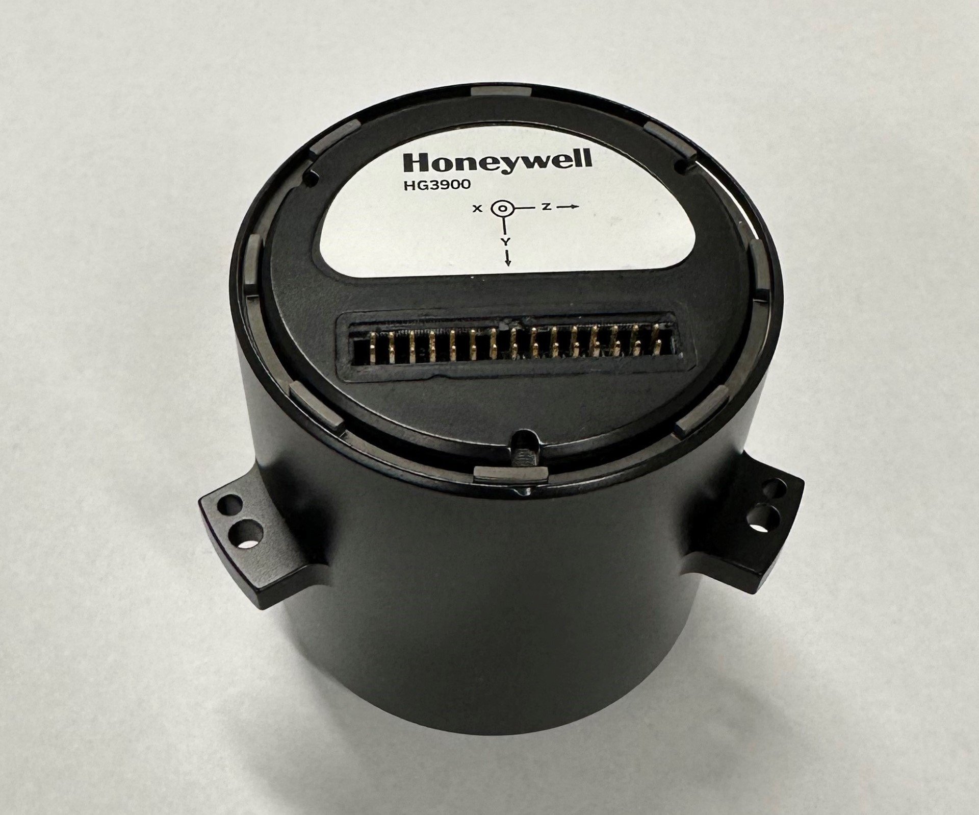
Honeywell has expanded its navigation portfolio with the HG3900 inertial measurement unit (IMU), a lightweight and low-power tactical-grade device with accuracy and reliability comparable to larger near-navigation-grade IMUs.
Honeywell will showcase the HG3900 IMU, along with the rest of its navigation products, at the Joint Navigation Conference in Cincinnati June 2-5, including a feature session on June 4.
The HG3900 is comprised of all-silicon microelectromechanical system (MEMS) gyroscopes and accelerometers, which enables a significant reduction in size, weight and power from comparable IMUs using traditional technologies. Its advanced sensors significantly boost its performance by offering a 20-time improvement over other Honeywell MEMs.
The HG3900 is designed for backward compatibility. As the highly successful Honeywell HG1900 IMU nears its end of life, the HG3900 will be offered in a nearly identical package to enable an easy transition for existing HG1900 customers.
The HG3900 IMU has successfully completed full environmental testing by the U.S. Army and Navigation Technology Associates (NTA), meeting requirements while under demanding environmental conditions including high vibration and dynamic temperature changes.
“Our HG3900 IMU is an ideal solution for customer applications requiring tactical or near-nav grade performance in a small, lightweight package,” said Matt Picchetti, vice president and general manager, Navigation and Sensors, Honeywell Aerospace Technologies. “Extensive Honeywell and customer testing demonstrates that our new IMU offers superior real-world performance in a smaller package.”
IMUs are widely used on aircraft, ships, spacecraft and other applications where precision positioning and navigation are critical. The importance of these devices has intensified considerably over the past decade with the significant growth in autonomous vehicles and other autonomy use cases. IMUs utilize gyroscopes, accelerometers and electronics to determine where a vehicle is, what direction it is going, at what speed and how far it has travelled.
Advanced MEMS IMUs such as the HG3900 are highly resilient and can provide accurate navigation and orientation data with or without GNSS inputs. They can function independently for extended periods when GNSS signals are jammed, spoofed or unavailable.
The design verification process will continue into 2026 with initial production and deliveries to begin in late 2026 or early 2027. Honeywell is accepting orders for pre-production units for delivery in 2026.
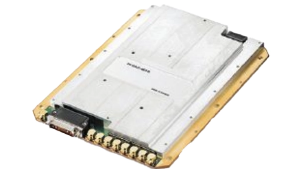
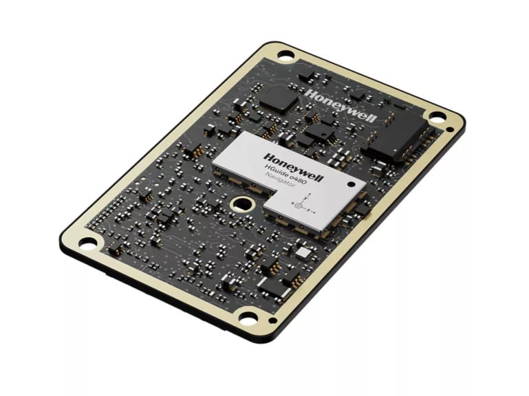
Honeywell has expanded its navigation portfolio with the HGuide o480, a high-performance, single-card inertial navigation system (INS) engineered to deliver precise, resilient localization and attitude data in a low size, weight and power package.
“The HGuide o480 is an engineering marvel and a technological breakthrough,” said Matt Picchetti, vice president, Navigation and Sensors, Honeywell Aerospace Technologies. “For the size, there are no competing products in the industry today that can achieve the same high-performance at the price point, in addition to having the ability to be augmented by the wide array of Honeywell alternative navigation capabilities to form a truly remarkable resilient navigation solution.”
The entire HGuide o480 product line is suitable for a wide range of industries, including the emerging small-factor unmanned aerial vehicles, autonomous ground and underwater vehicles, as well as an extensive range of aerial and terrestrial mapping systems for the geodetics industry.
The HGuide o480 can be integrated directly into the electronics stack of a range of applications requiring precise and robust localization. It can also reduce system size and integration complexity, enabling faster deployment and improved performance for unmanned and autonomous systems across air, land and sea. The system is fully compatible with multiple velocity aiding sensors, including the Honeywell Radar Velocity Sensor, and provides GPS-denied localization performance that is typically unavailable in similar systems.
Additionally, security is built into the fabric of the HGuide o480. Designed to perform in contested and GPS-challenged environments, the system features anti-jamming and anti-spoofing capabilities via Septentrio’s AIM+ technology included with the Mosaic global navigation satellite system (GNSS) receiver. The HGuide o480 is offered with both the triple-frequency Mosaic X5 in a single-antenna configuration and with the dual-frequency, dual-antenna Mosaic H for when GNSS attitude aiding is required. In both cases, the Mosaic delivers best-in-class real-time kinematic (RTK) GNSS performance.
Honeywell and NXP Semiconductors have expanded their partnership to advance aviation technology and autonomous flight capabilities. This collaboration merges Honeywell’s aerospace expertise and Anthem avionics system with NXP’s high-performance computing architecture to develop AI-driven aerospace technologies.
The partnership aims to enhance operational efficiency in flight planning and management while facilitating smoother transitions to new chipsets and technologies. The companies will focus on developing next-generation cockpit displays with improved visual clarity and system efficiency. They are also working on simplifying migrations to newer avionics technologies and extending the lifecycles of critical aviation systems, according to Honeywell and NXP.
NXP’s domain-based architecture, which includes high-compute capabilities, integrated cybersecurity and functional safety, will be adapted for aviation applications on Honeywell Anthem, the industry’s first cloud-connected cockpit system. This builds upon the companies’ collaboration in building management, fire safety and security products.
For aerospace applications, Honeywell will utilize various NXP processors, including the i.MX 8 applications processors and S32N super-integration processors. These processors will enable Honeywell Anthem to deliver faster data processing for real-time AI-driven insights, potentially enhancing safety and optimizing performance both in flight and on the ground.
Vertical Aerospace, a leader in electric vertical take-off and landing aircraft development, is set to be an early adopter of this collaborative technology, incorporating it into its piloted VX4 prototype aircraft.
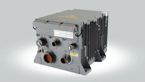
Honeywell has unveiled its resilient embedded GPS/inertial navigation system (EGI), designed to address the evolving challenges of modern warfare and meet U.S. government mandates for greater power competition. This navigation system integrates GPS and inertial navigation technologies to deliver precise position, velocity and timing information for various applications.
Expanding on Honeywell’s H-764 and FALCN, the EGI is specifically designed to fulfill military needs in areas where GPS jamming and spoofing are prominent. The system includes M-code capability, an atomic clock and open architecture compliance, allowing crucial mission flexibility with alternative positioning, navigation and timing (PNT) forms.
It allows for the seamless integration of various alternative PNT sources, including vision navigation, celestial navigation and magnetic navigation for continuous and accurate navigation even in the face of GPS threats.
Honeywell plans to make engineering units of this EGI available in early 2026, with certifiable units following shortly after. The company said this timeline allows for thorough testing and refinement, ensuring the system meets the reliability and performance required for critical military applications.
On May 8-11, GPS World staff attended the AUVSI XPONENTIAL show at the Colorado Convention Center in downtown Denver. There were more than 600 booths in the exhibit hall, and the staff was able to visit several of the exhibitors, including Tualcom, SBG Systems, Inertial Labs and Honeywell. They also attended educational sessions lead by industry leaders and participated in insightful discussions about the future of UAVs and overall autonomy. For highlights from XPONENTIAL, click here.
AUVSI XPONENTIAL 2023 has officially concluded. GPS World had the opportunity to visit several booths during the conference and attend a variety of educational sessions while in the heart of beautiful, downtown Denver.
“Protecting the Homeland: The future of C-UAS” was presented by industry leaders and highlighted capabilities available for detecting, intercepting, and mitigating UAS encroaching or threatening covered facilities, critical infrastructure, and other high-value targets in the National Airspace System.
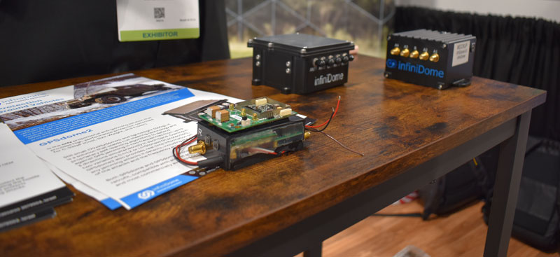
GPS World stopped by infiniDome to hear more about its solutions, including GPSdome.
“Autonomous Exploration and Mapping of Unknown Environments with UAS” dove into the development of simultaneous localization and mapping, world modeling and exploration-based planning algorithms. This session was led by Eric Thorn, manager in the Intelligent Systems Division at Southwest Research Institute.
Honeywell shared the ground station that it is developing.
While CGConnect has already been launched overseas by Advanced Navigation, its first debut in the United States was at XPONENTIAL.