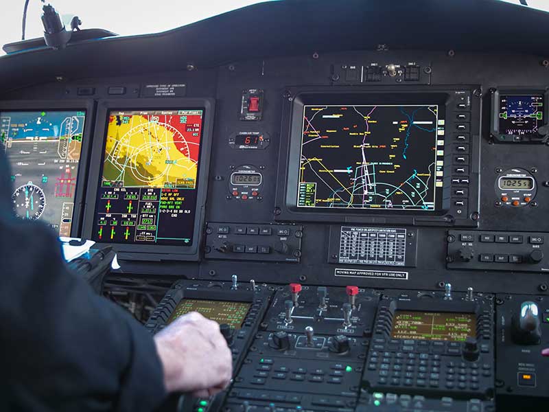
Honeywell is providing Leonardo’s helicopter division with a significant cockpit upgrade — Honeywell’s innovative Primus Epic 2.0 — for its AW139 helicopters. Primus Epic 2.0 will deliver better maps, improved situational awareness at night and in marginal weather, and easier access through wireless connectivity, improving safety and saving time. It is track based, meaning navigation follows the actual path of the helicopter and accounts for wind and other environmental factors.
The “synthetic vision” system enables pilots to fly a variety of challenging approaches. Helicopter-specific missions supported include corporate VIP transport, emergency medical services, oil and gas, and search and rescue.
The SmartView synthetic vision system is usable all the way down into the hover, helping pilots navigate during low-visibility conditions. These missions can include steep 9-degree descents into landing areas in challenging terrain and oil-rig approaches. Flight crews will also benefit from a more user-friendly, iNAV map visual interface with easy-to-use displays and an improved cursor that makes map manipulation and menu navigation more comfortable.
“Technology innovations are crucial to reducing pilot workload and making flights safer for crew and passengers,” said Mike Ingram, vice president and general manager, Cockpit Systems, Honeywell Aerospace. “With the Epic 2.0 Phase 8 upgrade, AW139 pilots will not only reduce the time and cost of some operations, especially those in weather and around challenging terrain, they will also experience some of the best safety features available anywhere in the helicopter market.”
The Phase 8 upgrade also increases connectivity capabilities, with Wireless Data Loading that lets pilots access data at high speeds remotely without a hardwire connection, transferring flight plans wirelessly and accelerating preflight actions.
GPS signals are by far the single most widely used and most accurate source of navigation, positioning and timing (PNT), and this capability is deeply integrated into every aspect of our society. In particular, the timing service provided by GPS, while virtually unknown to the general public, is essential for a variety of digital operations — from performing financial transactions to operating cell phone networks to running the internet.
Of course, GPS — originally developed to guide nuclear submarines — is now vital to most military missions, and the system’s vulnerabilities are a source of great concern.
GPS has been remarkably reliable over the past quarter century. Solar flares are rare, multipath can be largely mitigated, and obstructed line-of-sight to the satellites is an acute problem only in certain environments, such as urban canyons.
The most serious intentional threats to GPS are spoofing and jamming. Jamming is more widespread — it is more easily accomplished intentionally and it also occurs unintentionally. In the defense sphere, intentional jamming is a regular occurrence. It is expected as a routine aspect of electronic warfare operations to disrupt and deceive, typically just before the shooting begins. Unintentional jamming includes recently re-emerging concern about potential interference by ultra-wideband devices.
Experts at NovAtel, Collins Aerospace, L3Harris Technologies and Honeywell address the challenges posed by jamming and the relative effectiveness of various anti-jamming approaches.
NovAtel
Tackling Jamming on Multiple Levels
Disruption by jamming of GPS’s PNT data “is occurring with a growing regularity,” said Dean Kemp, Defense Segment manager at NovAtel, part of Hexagon’s Positioning Intelligence division. The problem will only increase, given our reliance on GNSS and increasing demand for precision. In the military sphere, electronic warfare in Syria, as well as jamming in Ukraine, Korea, and Finland, “have shown that modern, high-power equipment is routinely being used to disrupt the military.”
In the civilian sphere, interference is a growing issue because of cheap and effective jammers available via the internet. People use these so-called personal privacy devices to defeat vehicle tracking devices for purposes ranging from avoiding supervision all the way to hijacking vehicles.
GNSS signals are vulnerable because the received power is so small that receivers can be disabled with an incident power in the picowatt (10-12 W) range. “Jammers come in many different forms,” Kemp said, “from low-power civil devices to complex and powerful military-grade electronic warfare systems that can disable civilian receivers from a few hundred meters to hundreds of kilometers.”
Situational Awareness. Users can fail to recognize that their GPS is being jammed, Kemp said. Beyond defending against possible jamming scenarios, it is also necessary to “identify, find, and characterize the source of interference and to provide this information to the user so that it can be used appropriately.” In the defense field, this is known as situational awareness.
Emerging jamming threats, Kemp explained, can be understood within the context of cyber and information warfare using the Cyber Electromagnetic Activities (CEMA) layered approach. It recognizes a cognitive layer — a human decision based on PNT data; a virtual layer, in which PNT data are used to inform or support networked systems; and a physical layer, the hardware used to provide and protect PNT data.
Therefore, effective anti-jamming requires that:
users understand the system’s vulnerabilities and identify when they are being jammed, so that they can resort to traditional means for positioning and navigation (but not timing)
PNT data be protected and verified before being trusted
on the physical level, there be a multi-layered and heterogeneous approach that provides assured PNT information in the presence of jamming and spoofing without quantifiable loss of accuracy.
By combining these considerations at each layer, “they form a unified view on capability,” Kemp said.
Spoofing with Pokémon. Jamming threats are evolving, employed by both civilian and state actors. Worse, these threats are augmented by spoofing. While spoofing is harder to achieve than jamming, it is potentially more concerning. “Spoofing the receiver by rebroadcasting the GNSS signals or by generating them from a simulator has become a regular occurrence,” Kemp said.
Spoofing came to public attention in 2016 when enterprising programmers designed location-deception apps to hack the Pokémon Go mobile game. Instances have since been reported worldwide. Because early spoofing demonstrations were conducted against simple GPS L1 C/A-code receivers, it was initially hoped that spoofing could be defeated by using dual- or multi-frequency receivers.
However, it has been demonstrated that multi-frequency receivers using commercially available components can also be spoofed, “at least when the receiver is using multiple frequencies of GPS,” Kemp noted. “Adding further GNSS signals will help, but the best defensive measure is to employ, if authorized, an encrypted military signal.”
Coverage Improvement Factor. Typically, the effectiveness of an anti-jam system is assessed on the basis of the jamming to signal ratio (J/S) figure in decibels, which depends on variables such as the receiver’s front-end RF bandwidth, the signal type being tracked (C/A versus P(Y) code), the signal tracking threshold of the receiver, the receiver platform dynamics, the choice of receiver oscillator, the interference type and antenna characteristics.
Difference in how manufacturers calculate J/S led to the invention of the coverage improvement factor (CIF), adopted by the GPS Joint Project Office. “CIF gives a single number that describes the effectiveness of an anti-jam system for a particular jammer scenario, given that space vehicle positions vary by elevation and azimuth,” Kemp said.
However, the use of CIF to assess the anti-jam performance is a highly technical process and the results are usually classified. He discussed current approaches to anti-jamming.
Multi-element, controlled reception pattern antennas (CRPA), which pass the good signal to the receiver while nulling out the interference, are the first line of defense. “The system can dynamically change the gain pattern of the antenna so that as the platform and jammers move, the gain pattern adapts so that nulling continues effectively.”
The use of multiple constellations and frequencies can be an effective tactic to mitigate interference, “but relies on the jammer not covering the bands of interest.”
“Obtaining actionable data on interference is almost as important as mitigation,” because it enables users to modify plans. However, “interference effects can be difficult to diagnose and complicated to track down.”
Monitoring automatic gain control can indicate jamming.
“Coupling a GNSS receiver with a robust inertial measurement unit (IMU) will provide a higher level of protection for GNSS signals due to the IMU providing reliable position, velocity and attitude even through short periods when satellite signals are blocked or unavailable.” However, IMUs are liable to drift, resulting in degraded performance.
There are many approaches to designing anti-jam systems. They must be balanced against user requirements, which vary significantly. “A layered approach is the best form of defense against jamming and spoofing,” Kemp said, starting with protecting the incoming GPS signal. “One of the highest levels of protection is from an anti-jam antenna system paired with a GNSS receiver that is tightly coupled with an IMU.”
Finally, given that jamming attacks are now to be expected on the battlefield, it is critical to train users on the best response.
Collins Aerospace
Artist’s concept: Collins Aerospace
A Potent Triumvirate of Tools
While sources of deliberate jamming are on the rise, the vast adoption of GPS means that “even the non-deliberate sources of jamming will have an asymmetric impact on end users,” said Sai Kalyanaraman, Ph.D. and Technical Fellow at Collins Aerospace. Challenges posed by jamming depend on the receiver, mission and performance needs, while the source of unintentional jamming could be “something as simple as a TV antenna that is transmitting harmonics into the GNSS band.”
Kalyanaraman outlined viable approaches to interference mitigation and anti-jamming:
Integration with inertial navigation systems (INS) can provide the platform’s attitude, which is required for beam forming. This, in turn, is required for some of the CRPA GNSS Anti-jam signal processing modes. It can also alert the user of jamming when the INS position diverges dramatically from that provided by the GPS receiver.
Use of multiple frequencies is a form of robust design against interference.
For authorized users, M-code will provide additional limited capabilities against jammers.
Integration of GNSS with other PNT sensors to help address GNSS-denied environments.
GNSS signals have the advantage that the true signal is well under the noise floor; therefore, “as long as you can characterize the noise floor adequately from the receiver design/installation perspective, anything that shows up above the noise floor typically does not belong in that slice of the spectrum,” Kalyanaraman said. Combining a CRPA, a platform orientation sensor (like an INS), and a GPS/GNSS receiver, “you have a fairly potent triumvirate of tools that you can use to help mitigate the impacts of jamming and potentially spoofing.”
Collins produces multiple variants of its digital integrated GPS anti-jam receivers (DIGAR). “Depending on which variety you choose, you can essentially have a receive apparatus that can perform basic nulling all the way up to beam-forming and direction finding and help provide resiliency against high jamming signal levels and other threats that emulate a GNSS-like signal in space,” Kalyanaraman said.
L3Harris
L3Harris develops gun-hardened anti-jam solutions for the M1156 Precision Guidance Kit Modernization program. The kit turns 155-mm artillery shells into smart weapons. Here, soldiers test the kit for accuracy. (Credit: U.S. Army/Spc. Robert Porter)
Field Tests Verify PNT Reliability
Dealing with deliberate and unintentional interference with GPS requires agreeing on the level of enhancements required, reducing the time and cost needed to integrate them into systems of systems, and “centralizing PNT generation and distribution functions on a platform to reduce user equipment redundancies and increase the leverage of future PNT enhancements,” said Dave Duggan, president of the Precision Engagement Sector at L3Harris Technologies.
The increase in interference “creates a cascading negative effect to PNT client mission systems,” Duggan said, including the systems of systems for sensing, maneuver and fires [military-speak for the use of weapon systems].” The capability of anti-jam countermeasures “scales across a range of performance, size, weight, power and cost points and can be tailored to a given threat space, improving the performance of even legacy user equipment.”
Spoofing, which inhibits receivers from forming a solution or, worse, tricks them into passing misleading PNT solutions to other systems, is a bigger challenge than jamming because it can result in aborted missions and loss of life and usually requires new receivers, Duggan said.
Duggan defines a reliable anti-jam/anti-spoof capability as one that “provides a PNT solution with a high level of confidence in its accuracy, authenticity and integrity for their applications and anticipated threat environments — all at a reasonable cost/performance point.” Confidence in the solution requires “extensive analysis, threat modeling, simulation and testing of the anti-jam/anti-spoof capability.” For this reason, “L3Harris has worked extensively in developing simulation and testing environments of the highest fidelity and continues to participate in numerous live field test events to establish that foundation.”
L3Harris develops and produces digital anti-jam antenna electronics for U.S. and allied end use.
Honeywell
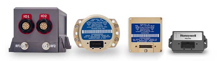
Honewell’s HGuide micro-electro-mechanical system (MEMS) inertial measurement units (IMUs) and INS are designed to be integrated with GNSS receivers. (Photo: Honeywell)
Integrating GNSS with Inertial
Heightened awareness of intentional and inadvertent jamming threats has less to do with new types of threats and more to do with the increased importance of precise PNT coupled with more frequent instances of jamming, according to Chris Lund, senior director, HGuide Navigation and Sensors at Honeywell Aerospace.
“As applications become more reliant on highly accurate and reliable position and timing information provided by navigation systems, the consequences associated with the data not being available or not being correct quickly escalate,” Lund said.
The best way to measure the impact of a jamming threat and the capabilities of countermeasures is “to determine in actual real-world use cases whether the desired application outcome can still successfully be achieved,” Lund said.
The most promising approach to anti-jamming is integration of GNSS receivers with inertial navigation systems (INS) and other PNT systems. “Given the complementary aspects of many of the available approaches in the anti-jamming toolkit, it’s often best to leverage however many tools are available and needed to allow the application to achieve its desired outcome,” Lund said.
Honeywell displayed its HG4930 MEMS-based inertial measurement unit (IMU) at Xponential 2019, which took place April 29-May 2 in Chicago.
The company emphasized the IMU’s rugged design, which the company says allows the IMU to meet the needs of the most demanding users. The HG4930 also features gyroscopes, accelerometers and an internal environmental isolation system.
Check out the video below, which showcases the HG4930 being treated as a hockey puck.
According to Honeywell, the HG4930 can be used for applications in the agriculture, automotive, communication, construction, energy, inspection, mapping, marine, mining, robotics, surveillance and transportation industries.
Honeywell has signed an agreement with the Greek Ministry of Maritime Affairs and Insular Policy to upgrade Greece’s search-and-rescue operations using next-generation, satellite-based tracking technology.
Under the agreement, Honeywell will provide the Hellenic Center of Mission Control with eight satellite antennas, three rescue control systems and computer equipment, as well as installation, customization, training and technical support services for seven years.
Using satellite signals, Honeywell’s technology can precisely locate emergency distress beacons and coordinate the deployment of rapid response teams, the company said.
The technology incorporates the COSPAS-SARSAT system, an international satellite-based program for distress alert detection and information distribution.
“By leveraging a network of ground-based antennas and medium earth orbit satellites, we can more precisely locate distress signals from emergency beacons,” said Mehrez Hached, director of business development for Honeywell’s Global Tracking and Search and Rescue business. “This Honeywell solution will help the Greek National Search and Rescue Coordination Center and the Hellenic Coast Guard save lives by quickly identifying aircraft, ships and people in distress regardless of how remote their location.”
Honeywell will install the satellite antennas on sites operated by the Hellenic Air Force and deploy management and surveillance equipment to the Hellenic Coast Guard Headquarters in Piraeus, Greece.
Honeywell’s search and rescue solutions are part of the company’s Safety and Productivity Solutions business. Honeywell provides fixed antennas, terminals, consoles and software applications to quickly locate missing assets on land or at sea and minimize emergency response times.
The company’s software offerings include SARMaster Search, a full-featured incident management application used by frontline operators to coordinate rescue operations, which has helped save tens of thousands of lives.
Honeywell’s tracking technology was incorporated into the European Space Agency’s Galileo search-and-rescue program, a pan-European program designed to dramatically reduce emergency response times using geo-positioning satellites.
Honeywell has released new smart airport technology that is designed to enhance the safety and efficiency of airside operations.
The Honeywell NAVITAS software suite intelligently integrates air and ground traffic control with maintenance operations so airports can more easily accommodate growing air traffic while promoting safety and on-time performance, the company said.
NAVITAS was developed to comply with the latest industry standards, including those from the International Civil Aviation Organization (ICAO), European Aviation Safety Agency (EASA), International Electrotechnical Commission (IEC), Federal Aviation Administration (FAA) and European Organisation for Civil Aviation Equipment (EUROCAE).
NAVITAS includes modular and scalable software components, combined with an intuitive user-friendly interface, providing real-time insights for air traffic controllers and maintenance operators.
The components assist personnel in visualizing and routing aircraft movements despite the increasing complexity and stress associated with today’s airport operations. NAVITAS can enhance situational awareness about traffic conditions, more safely expedite aircraft turnaround times, and automate fault diagnostics for airside equipment, among other features.
NAVITAS modules include Tower Manager, Engineering Manager, Surface Manager and Performance Manager.
Tower Manager helps improve the productivity of air traffic controllers by enhancing situational awareness of airport surface operations. It gives controllers access to rich, real-time information on ground, air traffic and meteorological conditions, presenting the information in a single easy-to-use interface, and providing visibility into a multitude of traffic events while reducing the chance for error.
The system helps manage the air traffic controller’s responsibilities, while making it easier to issue and track aircraft clearance information to keep landings and takeoffs safer and on time.
Surface Manager helps airports get more out of their existing infrastructure by enhancing ground traffic safety, fluency and throughput in a wide range of weather conditions, while helping to reduce their fuel burn and carbon footprint.
The module also provides the software necessary for airports to use all four levels of an Advanced-Surface Movement Guidance and Control System (A-SMGCS), including surveillance, routing, guidance and airport safety support, along with enhanced movement conflict detection and resolution, which can include “follow-the greens”-based guidance that automatically illuminates lighting on the tarmac to guide aircraft to clear taxiways.
Engineering Manager helps engineers and technicians manage maintenance by enabling them to more effectively monitor system health, more easily perform fault diagnostics and to streamline workflows, which also often helps reduce operational costs.
It features a mobile interface and automates the diagnostics and failure reporting, while simplifying manual tasks and reducing paperwork, giving personnel better visibility into the availability, reliability and performance of airside systems. Personnel can easily create, manage and issue work orders to expeditiously resolve issues and keep equipment up and running.
Performance Manager features dashboards that allow airport staff to collaborate and analyze operations in line with key performance indicators. The module — accessible both on premise and remotely — provides access to a common base of holistic information and allows for the application of big-data analytics for real-time and predictive insights, often enabling more efficient and informed decision-making.
“Airports around the globe are seeing dramatic increases in traffic, and while that makes the world more connected, it increases complexity to ensure safe and reliable operations,” said Sonja Strand, vice president and general manager for Honeywell’s Global Airports Business. “NAVITAS helps orchestrate these complex environments like never before through mobile applications, dashboards and heads-up displays that are intuitive. By harnessing the power of the internet of things, we’re making data user friendly, and making airports smarter in the process.”
Honeywell has launched its first commercial unmanned aerial vehicle (UAV) inspection service — the Honeywell InView inspection service — to help industrial customers improve critical structure inspections while helping increase employees’ safety from many of the risks associated with these often-dangerous working conditions.
Intel Falcon 8+ octocopter drone.
The Honeywell InView inspection service will combine the proven performance of the Intel Falcon 8+ UAV system and Honeywell’s expertise in the aerospace and industrial industries with data-driven software customized to the needs of the utility, energy, infrastructure, and oil and gas industries, the company said.
The Honeywell InView inspection service package, which includes the components of the UAV, pilot app and customizable web portal, helps customers organize and create standards around their routine and crisis-response inspections.
For example, the Honeywell InView inspection service can help utility customers create routine inspections of transmission and distribution systems that generate data that can be stored, searched and accessed from in the office and out in the field on demand.
“This collaboration combines Intel’s advanced commercial Intel Falcon 8+ UAV system with Honeywell’s leadership in aerospace safety and connectivity to deliver solutions that deliver reliable, efficient and actionable information to utility and industrial customers,” said Carl Esposito, president, Electronic Solutions, Honeywell Aerospace. “Through our extensive industrial experience, our customers will also gain access to Honeywell’s customized software and data solutions that will help them log, analyze, and eventually predict or prevent outages and structural failures, while protecting the men and women called upon to complete these crucial but high-risk jobs.”
“We are incredibly pleased to collaborate with Honeywell on this exciting new business opportunity,” said Anil Nanduri, general manager for Intel’s UAV business group. “The safety, flight precision and robust performance of the Intel Falcon 8+ system are a perfect fit for the Honeywell InView inspection service and will allow its customers to inspect, collect and analyze valuable data in a whole new way.”
With Honeywell’s InView inspection service, customers tap into Honeywell’s experience across vertical segments such as utilities, aerospace, connected building management, and oil and gas technologies.
In collaboration with Intel, Honeywell will utilize the intelligence and experiences of its diverse set of businesses to give customers a comprehensive solution and experience unrivaled in the marketplace.
“Technology, along with the Internet of Things, is enabling utilities around the world to modernize the management of their energy grids,” said Nitin S. Kulkarni, president, Smart Energy, Honeywell Home and Building Technologies. ” Honeywell brings together the technology that allows utilities to transform how energy is consumed in homes and buildings with software-based systems that help safely and efficiently manage complex industrial facilities and utility grids. Honeywell also has more than 100 years of experience providing dependable products and services to a variety of industries, of which Honeywell InView inspection service is the latest entry.”
Inspection Service goals
Keeping workers safe. According to the U.S. Department of Labor, utility line workers have one of the top 10 most dangerous jobs in the United States, with 21.5 annual fatalities from high-voltage lines for every 100,000 workers.
By using the inspection service, utility companies can send a UAV to perform routine inspections of substations, transmission towers and power lines while keeping boots on the ground and workers safe.
For utilities, using a UAV for inspections offers safer and more cost-effective means than existing methods using helicopters, cherry pickers, ladders and walking inspections.
Improving efficiency. Historically, inspections are siloed by organization and by individuals within organizations. Honeywell’s InView inspection service aims to create standardized inspections where customers can create operational efficiencies in the office and out in the field.
Data capture and analysis. UAVs are being touted for their data-gathering capabilities, but without analytics, more data is simply more data. Honeywell’s service can synthesize vast quantities of data to identify only what is needed and actionable, translating workers’ tacit knowledge into valuable information that provides actionable insights for business.
Connected Freight
Honeywell and Intel also recently collaborated to create a Connected Freight platform that gives shippers and logistics companies the unprecedented ability to monitor shipments of high value and perishable goods, helping prevent costly damage and loss.
The new Honeywell InView inspection service continues the work these two companies are doing to help various industries use connected devices to be more efficient and safer, and harness data in new and meaningful ways.
The webinar is free (register here) and focuses on applications in the electric utility/telecom sector, such as site inspections, drones and geographic information systems (GIS) mapping in general. Participants will learn how to maximize reach and capabilities using various sensors and technologies integrated with GPS aboard unmanned autonomous vehicle (UAV) platforms.
Agresta leads the U.S. marketing effort including customer use cases for Nearmap across industries.
Nearmap provides instant access to high resolution aerial imagery including ortho, oblique and now 3D — at scale. Today, this imagery is used for site locate analysis, planning and tracking change over time. The webinar presentation will review the different forms of imagery, how they are captured, managed and delivered in the cloud and used inside ESRI and AutoDesk.
Nearmap provides cloud-based subscription access to up-to-date 2-D orthomosaic aerial imagery. Using its patented HyperCamera2 technology, Nearmap is applying the same access model to the oblique aerial imagery market.
Screen capture from a Nearmap 3D fly-through of Austin, Texas, rendered from Nearmap oblique Imagery.
Because this new camera system provides a high degree of overlap from different angles, Nearmap can reconstruct the real world in stunning detail, producing not only high-resolution orthomosaic and oblique imagery, but also surface and terrain models, natural-color point clouds and textured 3-D meshes.
Other Speakers on the Panel
Jeff Fagerman, Lidar USA
Jeff Fagerman. Fagerman, a professional surveyor and certified photogrammetrist, is founder and owner of Lidar USA. He holds a master’s degree in photogrammetry from Purdue University. During his tenure with Intergraph from 1985 to 1999, he worked as a photogrammetric software developer on that company’s innovative photogrammetric workstations. In 1999, he started Fagerman Technologies, now known as Lidar USA. In 2010, the main corporate focus became mobile lidar aboard UAVs.
Lidar USA provides solutions for GIS, surveying, civil engineering, agriculture, forensics, BIM, heritage mapping — all things 3D and beyond. In addition to UAV-based mapping and surveying, the company has developed ground—based lidar, building an economical mobile mapping system called ScanLook, incorporating scanning, imaging, and navigation. The company has provided client services in survey/mapping, agriculture, law enforcement, military, archaeology, and education.
Chris Lund, Honeywell
Chris Lund, Honeywell Corporation. Lund will focus on inertial sensors as the centerpiece of any robust industrial positioning solution. Given they can’t be interfered with, inertial sensors are the glue that binds the information from all the other sensors together to reveal the desired insights and maximize operator uptime/efficiency.
Lund is a senior director of product marketing for Honeywell’s Navigation and Sensor business. He has experience running product lines for inertial measurement units as well as for surface and marine navigators. Previously, he had engineering roles as a researcher, project lead and technical manager. Lund has an M.S. in the management of technology. He has been working on navigation-related technologies since the late 90s, holds multiple patents, and has co-authored several conference papers and presentations.
Derrick Reish, LTI
Derrick Reish, Laser Technology Inc. (LTI). (LTI) started working with the U.S. government more than 30 years ago by designing lasers that measured distances between two planes in-flight for a de-icing exercise. The company then won a contract with NASA to build a custom laser that could measure both distances and speeds for space docking missions. Its first professional measurement device was a hand-held reflector-less total station launched the GPS laser offset sector.
LTI addresses real world needs and applications, including forestry, mining, utilities and surveying, among others. The company focuses on facilitating data collection and GPS/GNSS mapping for professionals, with innovative solutions aboard Android and UAV platforms.
One of the Honeywell Global Tracking ESA installations.
Honeywell’s Global Tracking solution has passed the final acceptance test for use on the European Space Agency’s (ESA) Galileo search and rescue program by demonstrating dramatically reduced emergency response times, Honeywell said.
Honeywell Global Tracking, part of Honeywell’s Scanning and Mobility business, is working in partnership with the Aerospace & Defense division of Capgemini, the prime contractor for the Galileo search and rescue program, to deliver a high-precision positioning system that is fully compatible with the international standard, which is known as the Cospas-Sarsat standard. Tests using the Honeywell system have proven that the time from beacon transmission to detection and processing has been reduced from several hours to a few minutes — often the difference between life and death in an emergency situation.
The international Cospas-Sarsat program is a satellite-based search and rescue distress alert detection and information distribution system, best known for detecting and locating emergency beacons activated by aircraft, ships and remotely located people in distress. Honeywell’s satellite tracking technology, which detects faint alerts sent by emergency beacons around the world using a combination of Doppler curves, noise reduction, and advanced signal processing, quickly calculates the exact location of the beacon and sends the results to the relevant Mission Control Centers in the region.
“Our Medium Earth Orbit-based search and rescue solution will lead to faster recovery missions and improved international search and rescue operations, and we’re pleased to partner with the European Space Agency to help execute on this important, life-saving system,” said David Sharratt, general manager, Honeywell Global Tracking. “With decades of experience developing this technology, Honeywell Global Tracking is the global leader of search and rescue solutions.”
“Up until now, Cospas-Sarsat has relied on satellites in low and high orbits, but medium orbits with satellites such as Galileo are better for search and rescue purposes; they combine a wide field of view with strong Doppler shift, making it more likely a distress signal is pinpointed promptly and accurately,” said Fermin Alvarez, ground station and fielding engineer with ESA. “Together with Honeywell, we are encouraged to see Galileo performing so strongly, thereby solidifying our ability to support precise and speedy search and rescue efforts.”
Honeywell Aerospace’s LASEREF VI navigation system has been selected by Airbus Helicopters for its light helicopter platforms, the EC145 T2 and EC645 T2 family.
The LASEREF inertial reference unit (IRU) allows helicopter operators to always have an autonomous navigation source available in the absence of a GNSS and radio navigation. The capability is especially useful when navigating during a mission when the GNSS is unavailable due to terrain masking, limited satellite constellation availability, or unintentional or intentional jamming.
“LASEREF will provide Airbus Helicopters with exactly what they’re looking for — an always-available and highly reliable navigation system,” said Varant Panossian, customer business manager at Honeywell Aerospace. “When you’re in extreme situations, navigation is essential for everything from crew safety to completing critical missions.”
Designed for fixed-wing and rotary-wing applications, the LASEREF is a light, small IRU that delivers the highest reliability in the industry, according to Honeywell. Its integration with GPS prevents delays in information delivery and keeps operations running safely and efficiently even under harsh environments and demanding mission situations.
Houston’s George Bush Intercontinental Airport (IAH) became fully operational with the first precision approach flown by a United Airlines aircraft using Honeywell’s SmartPath Ground Based Augmentation System (GBAS) on April 22. IAH is one of two airports in the country participating in a pilot program, in partnership with the Federal Aviation Administration (FAA), United Airlines and Honeywell to demonstrate the use of GBAS. This new system delivers a cost-effective solution to increase airport capacity, decrease air traffic noise and reduce weather-related delays.
“The Houston Airports are among the most innovative and progressive in the nation when it comes to safety and efficiently connecting passengers to destinations around the world,” said Mario Diaz, director of the Houston Airports. “It is imperative that we continue to invest in new technology that enhances the aviation sector.”
Honeywell’s SmartPath GBAS system augments GPS signals so they can be used for precision navigation in the approach and landing phases of flight. The flexible approaches provided by GBAS may produce a significant reduction in aircraft delays and carbon emissions at airports. The project is a component of the Federal Aviation Administration (FAA) Next Generation Air Transportation System (NextGen). It’s a migration from what is considered to be a ground-based air navigation system to a satellite-based navigation system which uses the same GPS that you use in your cars today.
“There is a great opportunity for SmartPath to modernize the flight experience for airline passengers,” said Pat Reines, senior manager, SmartPath Ground Based Augmentation Systems at Honeywell Aerospace. “We’re looking forward to helping Houston passengers and visitors’ experience more flights that depart and arrive on time.”
United Airlines will operate the flights with a Boeing 737 aircraft equipped with global navigation satellite system (GNSS) landing system (GLS) technology to receive the GBAS landing approach data. United was an early leader in NextGen technology, taking delivery of GLS-equipped aircraft since 2009.
“We believe that GBAS is the air carrier precision landing system of the future,” said Captain Joe Burns, United’s managing director of technology and flight test. “We continue to work closely with the FAA and our industry partners on GBAS and other NextGen initiatives.”
GBAS can provide aircraft with guidance to as low as 200 feet above the surface of the runway, referred to as a Category I approach. The FAA is currently validating the requirements for a GBAS to support Category II and Category III precision approach operations which would guide an aircraft to the surface of the runway. GBAS represents the only currently feasible satellite-based navigation solution for Category II/III precision approach operations, according to the Houston Airport System.
Honeywell this week introduced its Honeywell Instant Location System (HILS), a real-time asset management application that integrates a number of technologies, such as Ultra-Wideband, GPS, Wi Fi and RFID, with Honeywell’s process automation system, Experion Process Knowledge System.
Installed at locations throughout a facility, receivers can pinpoint the location of an employee or piece of equipment and send the information to the HILS server, which directly feeds the information to the operator’s workstation, according to Honeywell. The receivers can transmit data wirelessly using Honeywell’s OneWireless network.
One of the system’s major selling points is safety, the company says. Within seconds of a major plant incident, HILS can track employees and visitors through personal tags attached to their clothing and generate real-time mustering reports. These reports allow emergency responders to quickly obtain accurate head counts and locate missing or injured employees, according to Honeywell.
Integrated with Experion, HILS can use equipment and personnel geo-location information to improve plant safety as well, the company says. For example, HILS can use interlocks to ensure dangerous procedures are only executed when personnel are a safe distance from a process unit or machinery.
“This is the first real-time location system designed with the process industry environment in mind,” Jack Bolick, Honeywell Process Solutions president, said in a statement. “Integrating this technology with the control system produces a solution that gives manufacturers even greater awareness of what’s happening in their facilities. That awareness leads to safer and more efficient operations.”