New sensor provides easy-to-integrate, cost-effective, triple-redundant IMU hardware and software for guidance and navigation solutions in autonomous machines and vehicles
Photo: Aceinna
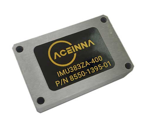
Aceinna has launched a new high-accuracy inertial measurement unit (IMU), the IMU383ZA. The sensor integrates triple-redundant, 3-axis micro-electromechanical system (MEMS) accelerometer and gyroscope sensors.
The IMU383ZA is an improved, pin-compatible version of Aceinna’s IMU381ZA. It offers high performance (1.3 deg/hr, 0.08 deg/root-hr) and a triple-redundant sensor architecture for ultra-high reliability.
The miniature module is factory-calibrated over the -40° C to +85° C industrial temperature range to provide consistent performance through extreme operating environments for a wide variety of applications.
Applications include automotive advanced driver-assistance systems (ADAS), autonomous systems, drones, robotics, agricultural, construction and other industrial machines.
The IMU383ZA provides a standard SPI bus for cost-effective board-to-board communications. Other features include advanced synchronization and a bootloader for field upgradeability.
Measuring 24 x 37 x 9.5 millimeters, the IMU383ZA integrates a triple-redundant architecture that — combined with the small, low-cost packaging — meet the challenging performance, reliability and cost requirements of the automotive market including the areas of autonomous vehicles, self-driving taxis/delivery vehicles, ADAS systems, electronic stability control and lane-keep assist applications.
The triple-redundant sensor architecture consists of three independent, 3-axis accelerometer and 3-axis gyros for excellent accuracy and reliability. By embedding a triple-redundant sensor array, the IMU383ZA uses Aceinna’s proprietary voting scheme to utilize only valid sensor data. Any defective sensor output or errant dataset will be ignored or de-rated in importance.
SBG Systems has opened a new subsidiary in Singapore. Located in the center of the city, this new office brings sales and technical support to the Asian region.
SBG Systems is a leading supplier of MEMS-based inertial measurement units (IMU) and inertial navigation systems (INS) for land, air and marine applications. The company has been developing its sales distribution channels in Asia for many years and has decided to bring sales and technical support closer to its clients and distributors by establishing a subsidiary in Singapore.
“We wanted to get closer to our customers and distributors in the region,” said Thibault Bonnevie, SBG Systems’ CEO. “By getting geographically closer, we wish to build closer relations with our esteemed customers and distributors and provide them with the highest quality service they deserve.”
The Singapore office will provide support to new and existing clients in the region with demonstrations, training and technical support.
Module designed for developers creating guidance and navigation systems for autonomous vehicles, robots, drones, industrial, construction and agricultural machinery
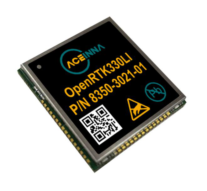
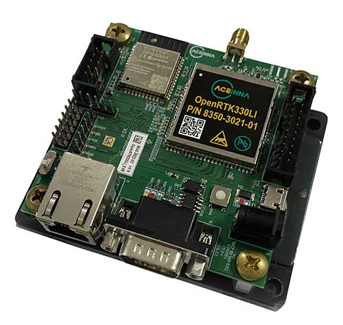
Aceinna launched its OpenRTK330L at CES 2020, the massive annual consumer electronics show taking place Jan. 7-10 in Las Vegas. The company is located at Booth 6738, CES North Hall, Automotive Pavilion.
OpenRTK330L is a low-cost,high-performance triple-band RTK/GNSS receiver with built-in triple redundant inertial sensors. Designed to replace the expensive and bulky precision RTK/INS systems used in today’s autonomous systems, the compact navigation solution meets the challenging performance, reliability and cost requirements of the automotive market along with the needs of robot, drone, construction and agriculture systems, Aceinna said.
Demonstration Drive
Aceinna is demonstrating its GNSS/INS-based autonomous vehicle localization technologies on its test vehicle, which drove from Silicon Valley to Las Vegas.
The company is recording live drive-test data that demonstrates how its precision positioning solutions provide high accuracy and reliability. Precision location capability is critical for all levels of autonomous driving.
OpenRTK330L includes a triple-band RTK/GNSS receiver coupled with redundant inertial sensor arrays to provide cm-level accuracy, enhanced reliability, and superior performance during GNSS outages.
The OpenRTK330L integrates a precise 2 Degree/Hour IMU to offer ten to 30 seconds of high accuracy localization during full GNSS denial. This enables autonomous system developers to safely deliver highly accurate localization and position capabilities in their vehicles at prices that meet their budgets.
Image: Aceinna
OpenRTK330L’s embedded Ethernet interface allows easy and direct connection to GNSS correction networks around the world. OpenRTK330L’s CAN bus interface allows simple integration into existing vehicle architectures.
The multi-band GNSS receiver can monitor all global constellations (GPS, GLONASS, BeiDou, Galileo, QZSS, NAVIC, SBAS) and simultaneously track up to 80 channels. The module has RF and baseband support for the L1, L2 and L5 GPS bands and their international constellation signal equivalents.
The inertial measurement unit and dead reckoning function contains a total of 9 accelerometer and 9 rate gyro channels based on Aceinna’s unique triple redundant six-axis IMU array. By integrating a triple-redundant IMU array, the OpenRTK330L is able to recognize and utilize only valid sensor data, ensuring high-accuracy protection limits and certifiability under ISO26262 standards.
Open Navigation Platform
“The combination of a triple-band GNSS receiver and a high-precision IMU has enabled us to make a remarkably accurate, small, reliable and cost-effective GNSS/INS solution,” said Mike Horton, CTO of Aceinna. “The OpenRTK Precise Positioning Engine optimizes satellite tracking and high RTK fixes rates while integrating seamlessly with Aceinna’s open-source, developer-friendly Open Navigation Platform.”
The Open Navigation Platform allows custom embedded application development on top of Aceinna’s positioning engine and dead-reckoning algorithms. Autonomous solution developers have full access to all resources on the OpenRTK330L module including the GNSS receiver measurement data, IMU measurement data and all interfaces.
The OpenRTK330L GNSS receiver supports GPS (L1 C/A, L2C and L5), GLONASS (L1OF, L2OF), BeiDou (B1I, B2I), GALILEO (E1, E5a, E5b, E6) QZSS (L1 C/A), and NAVIC. The IMU sensor array includes a triple-redundant, 3-axis MEMS angular rate sensor, and a triple-redundant, 3-axis MEMS accelerometer.
Hardware also includes, Ethernet, UART, SPI and CAN interfaces for versatile integration into a host system. Additional specifications include operating temperature range of -40C to +85C, and qualification to standard automotive shock and vibration levels.
SBG Systems‘ Raphaël Siryani discusses the company’s product line at Intergeo 2019, which took place Sept. 17-19 in Stuttgart, Germany. Siryani also explains the features of SBG Systems’ Horizon, a FOG-based high performance inertial measurement unit (IMU) designed for large hydrographic vessels surveying harsh environments.
The REASON project uses satcom signals to help long-range missiles navigate. (Image: MBDA)
MBDA Missile Systems is exploring a navigation solution for long-range cruise missile systems that would use satellite communications signals to maintain precision navigation accuracies at range, reports Jane’s 360.
MBDA told Jane’s that is has demonstrated for the first time a satcom-aided navigation as part of the Resilient and Autonomous Satcom Navigation (REASON) project. Also taking part in the project are Airbus Defence and Space and ONERA.
REASON is part of the UK/French Materials and Components for Missiles Innovation and Technology Partnership (MCM IPT) programme, for which MBDA is the lead.
REASON is evaluating the technical and system-level feasibility and benefits of using specialist satellite signals to aid navigation.
For a medium-to-long duration flight, cruise missile systems require additional information to support inertial measurement unit (IMU) sensors to achieve the required level of guidance accuracy, Jane’s reported. Recent years have seen greater reliance on GPS/GNSS signals to provide navigation updates to correct IMU drift.
VectorNav Technologies’ tactical series line of inertial measurement units (IMUs) and GNSS-aided inertial navigation systems (GNSS/INS) have completed independent testing for MIL-STD-810G, DO-160G, MIL-STD-1275E and MIL-STD-461.
Completion of the MIL-STD and DO-160 qualification tests proves the robustness of the tactical series to a range of temperature, shock, vibration and other environments, as well as conformance to numerous electrical interface and EMI standards.
The testing demonstrates an advantage of the tactical series for defense and aerospace applications. Other advantages are the modules’ SWAP-C (size, weight, power and cost) and performance characteristics.
“There is high demand for dependable, tactical-grade navigation solutions that perform in challenging environmental and operating conditions,” stated VectorNav Director of Sales and Marketing Jakub Maslikowski.
VectorNav’s tactical series includes the VN-110 IMU/AHRS, the VN-210 GNSS/INS and the VN-310 GNSS-compass aided GNSS/INS.
VectorNav’s new Tactical Series includes the VN-110 IMU/AHRS, the VN-210 GPS/INS and the VN-310 dual-antenna GPS/INS. (Photo: GPS World)
The products include an onboard tactical-grade IMU (<1˚/hr in-run gyro bias stability), along with VectorNav’s proprietary filtering, INS and GNSS-compass algorithms.
The products offer 1 to 2 mrad attitude performance in compact, rugged enclosures and include a 10-pin auxiliary port for integration with external real-time kinematic and SAASM-based GNSS receivers, as well as higher-performance IMUs.
Testing for the MIL-STD and DO-160 standards was performed by independent, certified testing companies in Plano, Texas, and Huntsville, Alabama.
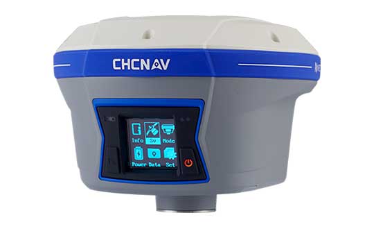
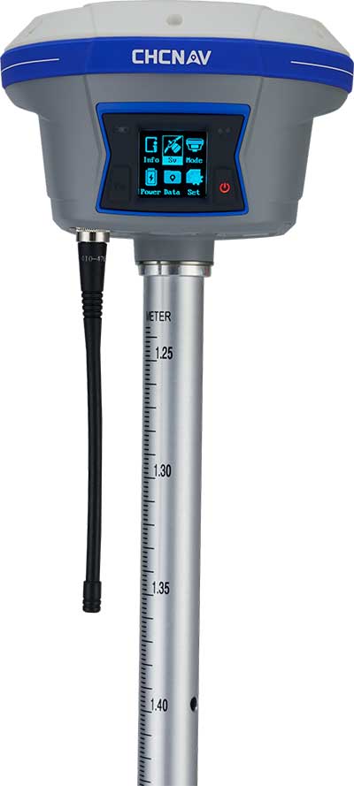
CHC Navigation has released and is immediately shipping its new i90 IMU-RTK GNSS Series receiver. The i90 IMU-RTK GNSS Series is designed to dramatically increase GNSS real-time kinematic (RTK) availability and reliability.
The i90 is powered by the company’s latest inertial measurement unit (IMU) and RTK technology to provide robust and accurate GNSS positioning in any circumstances.
Unlike standard micro-electro-mechanical (MEMS)-based GNSS receivers, the i90 GNSS IMU-RTK combines a high-end calibration and interference-free IMU sensor with a state-of-the-art GNSS RTK engine and advanced GNSS tracking capabilities.
The i90 is designed to increase productivity and reliability of survey projects. No complicated calibration process, rotation, leveling or accessories are necessary with the i90 GNSS Series. Just a few meters’ walk will initialize the i90 internal IMU sensor and enable RTK survey in difficult field environments. The i90 GNSS automatic pole-tilt compensation boosts survey and stakeout speed by up to 20%.
“Our new i90 IMU-RTK GNSS Series is pushing the boundaries of conventional GNSS survey by extending RTK positioning availability and reliability,” said George Zhao, CEO of CHC Navigation. “CHCNAV is the GNSS technology enabler, making high-end GNSS solutions available for every surveyor.”
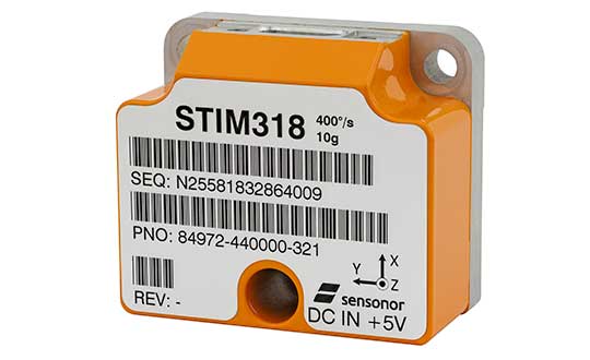
The new high-accuracy tactical-grade STIM318 inertial measurement unit (IMU) from Sensonor provides greatly increased accelerometer performance to support demanding guidance and navigation applications, the company said. Its performance can in many applications competitively replace fiber-optic gyros (FOGs).
Offering improved system performance with respect to robustness, reliability, size, weight, power and cost, it is designed for use in autonomous machine control, UAV payloads, satellites, portable target acquisition systems, land navigations systems, turret stabilization, missile stability and navigation, and mortar aiming systems.
STIM318 is comprised of three highly accurate MEMS gyros, three high-stability accelerometers and three inclinometers. Its development took place in close cooperation with a global customer developing autonomous machine control for accurate contour guidance. The IMU is built on the established STIM design that is field proven in commercial and military applications.
An ITAR-free product, STIM318 is available in export controlled and non-export controlled versions. It is compatible with Sensonor’s STIM300 IMU, and can bring additional capability to applications already using STIM300. STIM318 is available from stock.
In addition to the performance increase, STIM318 comes with a new Bias Trim Offset (BTO) function. This allows the user to individually zero out any bias of all 9 axes. The bias offset can be stored in flash, and then recalled at next system startup.
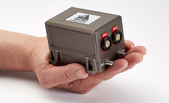
NovAtel, part of Hexagon’s Positioning Intelligence division, now brings users greatly improved processing speed and accuracy as well as significantly reduced signal acquisition time through the latest 7.07.03 firmware release.
The SPAN CPT7. (Photo: NovAtel)
The firmware works best with the recently launched TerraStar-X correction service, which delivers accuracy and reliability, as well as the OEM7, SPAN CPT7 and PwrPak7 products, which use signals from all GNSS constellations and frequencies to provide users with reliable autonomy and exceptional positioning availability.
The 7.07.03 firmware offers a significant improvement to the SPAN GNSS + INS (inertial navigation system) technology. SPAN with 7.07.03 shows improvements of up to 20% in the horizontal position over the entire SPAN IMU catalog and across various industry use cases including agriculture and marine. SPAN with 7.07.03 also provides improved motion detection, resulting in more robust time to convergence.
“The 7.07.03 firmware features improvements to both our SPAN Marine and SPAN Rail profiles that will greatly impact application performance and consistency,” noted NovAtel Director of Product Management, Neil Gerein, “The SPAN Marine Profile sees improvements to the heave performance and will allow users to start their work significantly faster thanks to a simplified setup for applications in marine dynamics. The SPAN Rail Profile improves position accuracy over long GNSS outages, which is crucial for applications in rail environments that often deal with potential signal obstructions such as trees, tunnels and dense urban areas.”
To download the 7.07.03 firmware update for your platform, click here.
Higher rate, higher acceleration applications benefit from SWaP-C advantages of MEMS-based inertial systems.
Gladiator Technologies’ LandMark 007 inertial measurement unit (IMU) combines low noise, high range sensors and Velox high-speed output in a rugged IMU package measuring 0.7 inches square. With rate ranges up to 2000°/s and acceleration ranges as high as 200 g, the LandMark 007 IMU provides demanding, precision performance for a range of high dynamic, rugged applications.
Photo: Gladiator Technologies
All LandMark 007 IMUs feature Velox high-speed message timing to minimize digital message phase lag. They also include high-speed output data rates (up to 10 kHz) for measurement accuracy and flexibility.
These high-speed features are complemented by low-noise gyros with a gyro angle random walk (ARW) of <0.0035°/s/√Hz (0.15°/√hr) and low-noise accelerometers with a velocity random walk (VRW) of <6 mg/√Hz.
“The LandMark 007 IMU is uniquely designed to meet the industry’s need for a compact, rugged and high performance, cost-effective IMU. Extensive conditioning and testing ensure reliable, stable measurements for our customers with high dynamic applications,” said Eric Yates, Gladiator Technologies’ sales manager. “We are seeing strong interest in the LandMark 007 and LandMark 007X IMUs from applications which otherwise have been limited to highly specialized, and therefore expensive, IMU solutions.”
IMUs with less than or equal to 98 g linear acceleration range are designated as LandMark 007 IMUs. IMUs with greater than 98g linear acceleration range are designated as LandMark 007X IMUs. The LandMark 007 IMU is exported categorized as ECCN7A994 and the LandMark 007X is export categorized as ECCN7A103.
A LandMark 007 IMU development kit is available for set-up, configuration and data collection.
A roundup of recent products in the GNSS and inertial positioning industry from the July 2019 issue of GPS World magazine.
OEM
Inertial sensors
Sensor fusion with GNSS receiver
Photo: xsens
The MTi 600-series of inertial sensors comes in a 31.5 x 28.0 x 13.0 millimeter IP51-rated case. It produces roll and pitch readings accurate to ±0.2 degrees. GNSS-assisted heading (yaw) measurements are accurate to ±1.0°. Xsens’ sensor fusion algorithms optimize output from new accelerometer, gyroscope and magnetometer components. It also has a CAN bus interface. The MTi 600-series modules are the first from Xsens to include an NMEA-compatible interface for GNSS receivers. Users can choose any GNSS receiver chip, module or system to work alongside the MTi-670, a GNSS/INS device that supplements the pitch, roll and yaw outputs available from other MTi 600-series products with global positioning information. Xsens, www.xsens.com
Fiber-optic gyroscope
For medium accuracy platforms
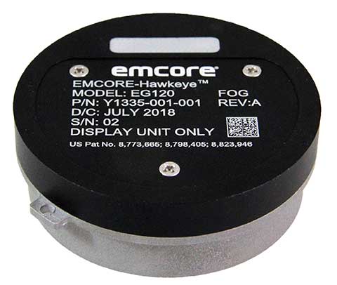
Photo: Emcore
The Emcore-Hawkeye series EG-120 FOG module is an ultra-compact, state-of-the-art design that is a small, affordable closed-loop FOG. The EG-120 delivers advantageous size, weight and power (SWaP) and is 35% smaller than Emcore’s previous generation FOGs. The Emcore-Hawkeye EG-120 incorporates advanced, next-generation field programmable gate array (FPGA) electronics that deliver increased performance and reliability combined with low cost. The Emcore-Hawkeye series features performance specifications for medium accuracy platform stabilization applications such as camera systems used in aircraft, unmanned aerial vehicles (UAVs) and gun stabilization systems. A wide variety of other guidance, navigation and aeronautics applications are supported. Emcore, www.emcore.com
Navigation system
Customizable for ground vehicles of all sizes
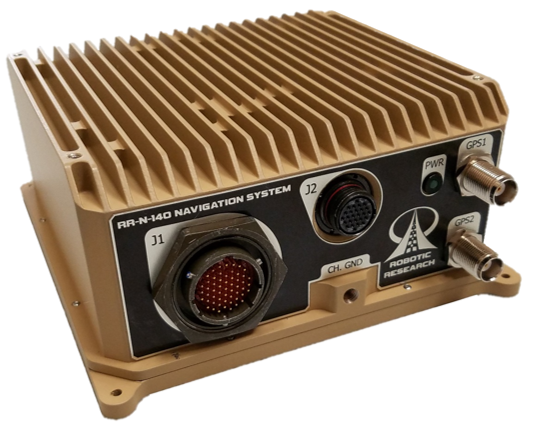
Photo: Robotic Research
The RR-N-140 navigation system provides accurate, absolute and relative 3D localization information for ground vehicles of all sizes. It features dual-antenna GNSS for zero-speed heading detection and redundancy. The device delivers exceptional localization performance in GPS-denied or compromised areas. It is designed specifically for use on unmanned ground vehicles and is customizable to incorporate a wide variety of sensor inputs into the navigation solution. Robotic Research, www.roboticresearch.com
GNSS sensors
Combines numerous interfaces to speed system integration
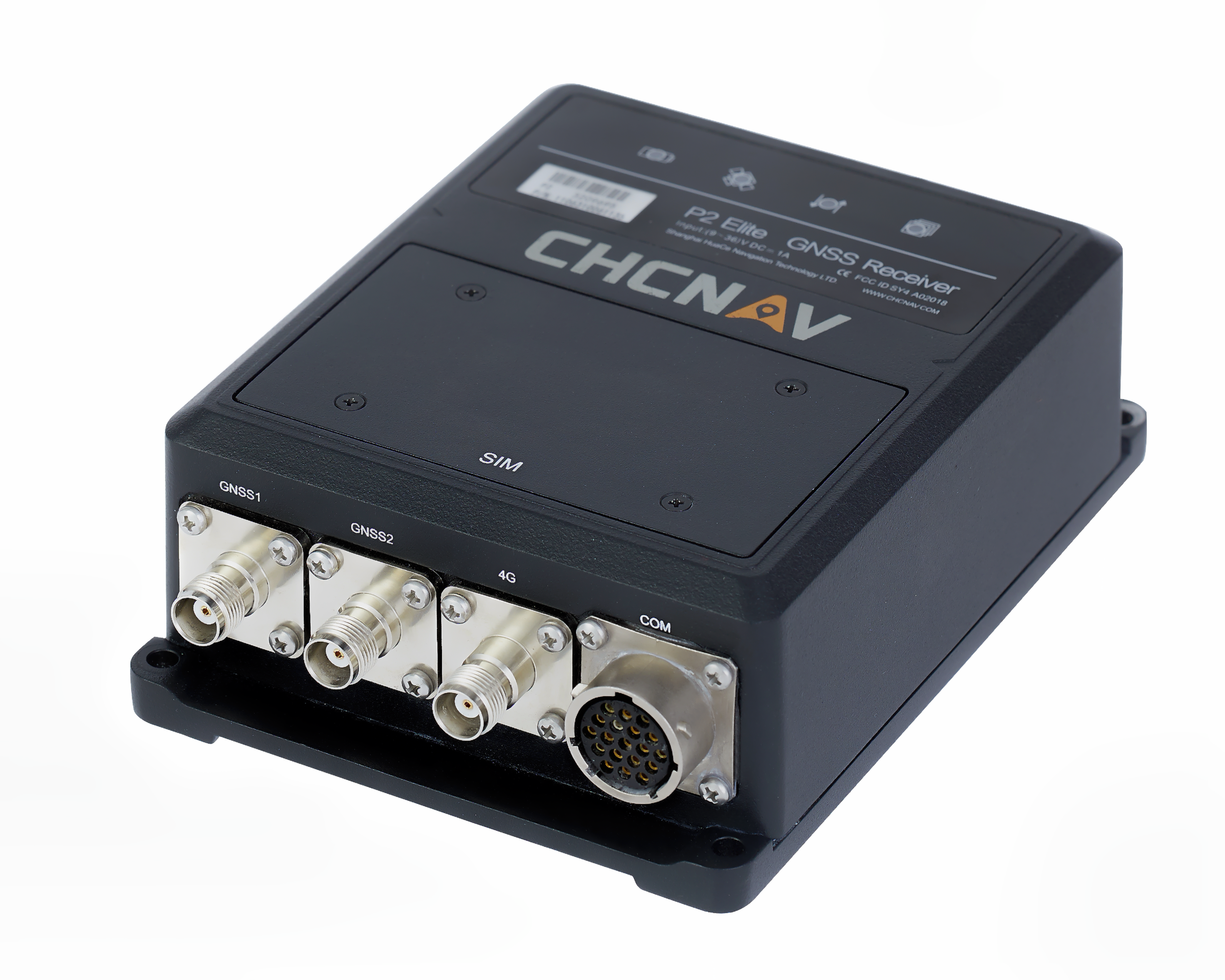
The P2 Elite GNSS sensor. (Photo: CHC Navigation)
CHC Navigation’s new P2 GNSS sensor series provides high-accuracy positioning and heading in a compact, rugged enclosure. The series is suitable for a wide variety of applications such as reference stations, marine systems, unmanned navigation, industrial automation, robotics and machine control. The P2 GNSS series is designed to significantly reduce system integration efforts by combining numerous connectivity interfaces including RS232, low-latency PPS output, Ethernet, CAN bus protocol and a comprehensive web interface for configuration set-up. The series integrates the latest GNSS technology in a rugged IP67 and lightweight enclosure. It delivers reliable, uninterrupted, high-accuracy, real-time positioning and heading measurements. The P2 GNSS sensor offers cost-effective and powerful real-time kinematic (RTK) positioning. The P2 Pro GNSS adds a dual-antenna input for precise heading data. The P2 Elite integrates additional 4G and UHF modems to provide a powerful, all-in-one GNSS sensor. CHC Navigation, www.chcnav.com
TRANSPORTATION
Correction stream
Data enables precision positioning
RTX Auto is a GNSS software library for use in safety-critical automotive applications. The RTX Auto library can be integrated with any GNSS device and enables the decoding of Trimble’s RTX correction stream for centimeter-level absolute positioning accuracy. It works with other on-vehicle sensors to deliver a certified positioning solution that satisfies advanced driver assistance systems (ADAS) and autonomous driving requirements. It provides RTX-based absolute positioning for General Motors’ Super Cruise, a hands-free driving system for the freeway. After 2020, Super Cruise will will be available on all General Motors brands. Trimble, trimble.com
Smart antenna
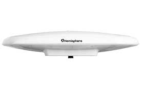
Atlas-capable for marine markets
Photo: Hemisphere GNSS
The Vector V200 single-frequency, multi-GNSS smart antenna with integrated Atlas L-band is designed for general marine applications and markets. Powered by Hemisphere’s Crescent Vector technology, the V200 multi-GNSS compass system utilizes GPS, GLONASS, BeiDou, Galileo and QZSS (with future firmware upgrade and activation) for simultaneous satellite tracking to offer heading, position, heave, pitch and roll output. With support for NMEA 0183 and NMEA 2000, the V200 provides accurate position and heading information to autopilots, chart plotters and other general marine navigation applications. Hemisphere GNSS, www.hemispheregnss.com
Driver safety solution
Security for intelligent driving
The Proactive Security Solution for Intelligent Driving will enhance safety by supporting ADAS and driver monitoring systems (DMS). It integrates Quectel multi-mode LTE Cat 6 smart modules SC600Y/SC600T and an artificial intelligence (AI) algorithm from a third party to realize ADAS and DMS capabilities including monitoring irregular driving behaviors, conducting precise detection of vehicles and traffic signs, sending warnings of potential risks and more. For ADAS, it can precisely identify and locate vehicles, pedestrians, lanes and traffic signs and will send alerts to drivers if an imminent collision or an unintended lane departure is detected. The DMS supports facial recognition and detection, and is able to monitor driver attentiveness and measure eye blinks as well as head movements so that drivers will receive warnings of distractions, smoking, yawning or looking around. Quectel Wireless Solutions, www.quectel.com
Automotive module
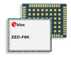
Aimed at urban lane accuracy
The ZED-F9K module is designed to keep cars in their lanes. (Photo: u-blox)
The ZED-F9K GNSS and dead-reckoning module brings continuous lane-accurate positioning to challenging urban environments. Building on the F9 platform, the module offers both high-precision multi-band GNSS and inertial sensors. It combines the latest generation of GNSS receiver technology, signal processing algorithms and correction services to deliver down to decimeter-level accuracy within seconds. The real-time kinematic (RTK) receiver module receives GNSS signals from all orbiting constellations. The inertial sensors constantly monitor changes in the moving vehicle’s trajectory and continue to deliver lane-accurate positioning when satellite signals are obstructed, such as in parking garages, tunnels, urban canyons or forested areas. The module’s accuracy and low latency make it suitable for automotive OEMs and Tier 1 automakers developing V2X (vehicle-to-everything) communication systems. By continuously sharing their location, V2X systems help increase overall road safety and reduce congestion. u-blox, www.u-blox.com
The Quanta UAV series is a line of inertial navigation systems (INS) dedicated to UAV-based surveying integrators. The small, lightweight and low-power INS is offered with two levels of accuracy. Quanta UAV and Quanta UAV Extra have been developed for compact lidar to high-end beyond-visual-line-of-site (BVLOS) mapping solutions. They provide precise orientation and centimeter-level position data both in real time and in post processing, eliminating the need for ground control points and reducing the need for overlaps. SBG’s post-processing software Qinertia gives access to offline real-time kinematic (RTK) corrections from more than 7,000 base stations in 164 countries. SBG Systems, www.sbg-systems.com
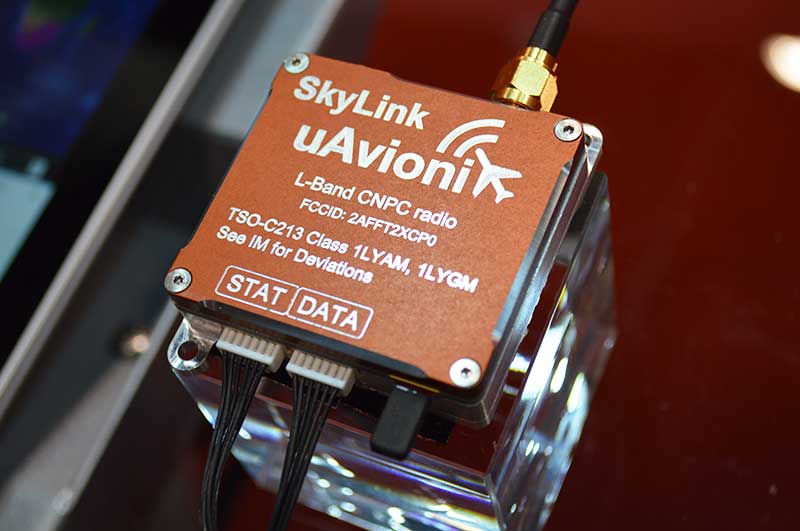
CNPC radio prototype
Being tested as command and non-payload control UAS radio
Photo: Allison Barwacz
SkyLink is an L-band frequency-modulated CNPC radio intended for point-to-point or networked BVLOS UAS operations. uAvionix has focused on minimizing size, weight, and power consumption (SWaP) while maximizing range and spectrum efficiency. The current 50-gram 10-Watt prototype is testing successfully at ranges exceeding 40 miles at low altitude. uAvionix is testing under an experimental transmit license and approval from the Federal Communications Commission and Federal Aviation Administration, respectively. uAvionix, uavionix.com
Thermal drone
Designed for solar farm inspections
The senseFly Solar 360 UAV is designed to enable the automated and efficient inspection of solar farms. Created in collaboration with software company Raptor Maps, the efficient thermal drone solution enables the automatic assessment of solar plant performance at a sub-module level. Created by combining eBee X fixed-wing drone technology, senseFly’s Duet T thermal mapping camera and Raptor Maps software, senseFly Solar 360 is a fast and fully automated drone. It can be integrated into solar management workflows without requiring either drone piloting skills or the manual analysis of aerial solar-farm data. Solar-farm inspection can be reduced from days to hours, with inspection of utility-scale solar farms completed more quickly, easily and accurately. SenseFly, www.sensefly.com Raptor Maps, raptormaps.com
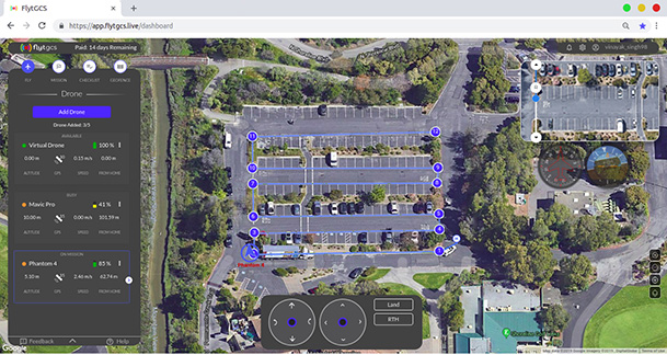
Remote operations
Cloud-based, enables BVLOS
Photo: FlytBase
FlytGCS is built for subject-matter experts, drone operations managers and UAV operators who wish to automate, simplify and scale their missions. To support automated BVLOS missions, FlytGCS offers features such as connectivity and control over 4G/LTE/5G, live high-definition video feed, fleet management, unlimited missions, remote gimbal control, pre-flight checklist and geofence, mission planner and cockpit view from a web dashboard. FlytGCS is a hardware-agnostic solution that helps securely deploy drones using a mobile app (for DJI drones) or onboard single-board computers (for Ardupilot and PX4 drones). FlytBase, flytgcs.live
Inspection drone
Collects data in dangerous areas
The Elios 2 is a collision-tolerant drone for indoor inspections. (Photo: Flyability)
The Elios 2 UAS is designed for inspection tasks. Routine inspection jobs indoors, underground and around complex pipework become quicker, safer and are fully documented by high-resolution video and stills. The Elios 2 includes a rotatable thermal and high-definition visual camera payload, 10,000-lumen oblique lighting system, and reversible rotors that enable the UAV to back out of tricky situations. The drone’s geodesic-like cage makes it collision-tolerant and enables flight in restricted areas such as refinery enclosures, mines, vats, cargo holds and nuclear containment vessels. Flyability, www.flyability.com
SURVEY
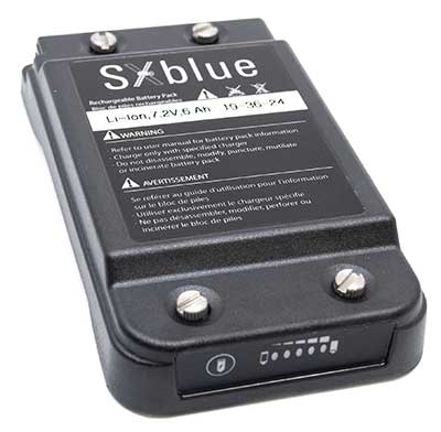
Battery upgrade
Long-life battery for extended fieldwork
Photo: Geneq
SXblue receivers now have an extended-life battery equipped with 4 Li-ion rechargeable cells that boost its capacity from 3900 mAh to 6000 mAh. When fully charged, the battery can last up to 16 hours depending on the SXblue model and Bluetooth connectivity — an up to 50% increase. The colored LEDs for the battery charge indicator have been enhanced for a better contrast. With only a 6-mm increase in thickness and the same weight as previous models, the user will not notice any change in handiness and ergonomics. The new battery is compatible with all past SXblue II and III models and current iSXblue II+ GPS, SXblue II+ GPS, iSXblue II+ GNSS, SXblue II+ GNSS and SXblue Platinum. Geneq, geneq.com
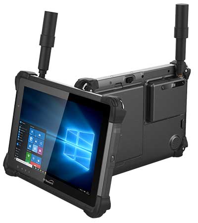
Fieldwork tablet
Captures detailed images
DT301X-TR rugged tablet. (Photo: DT Research)
The DT301X-TR rugged tablet includes an Intel RealSense 3D camera. The lightweight military-grade tablet is built to enhance precision for bridge and construction inspections, 3D surveying and mapping of underground utilities. It provides multi-frequency GNSS real-time kinematic (RTK) with carrier phase for mapping and positioning, and supports GPS, GLONASS, BeiDou, Galileo and QZSS. An optional foldable antenna supports high-accuracy field work, which can be measured with RTK GNSS positioning directly or used to connect to an external antenna for higher precision. DT Research, www.dtresearch.com
GNSS Receiver
Dual-antenna receiver with heading
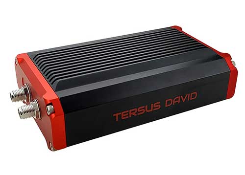
Photo: Tersus GNSS
The David Plus dual-antenna GNSS receiver offers centimeter-accurate positioning and heading for intelligent transportation, construction, machine control, precision agriculture and navigation. Designed for efficient and rapid integration, the compact, lightweight receiver tracks GPS, GLONASS and BeiDou signals: GPS L1/L2, GLONASS L1/L2, BeiDou B1/B2 from the primary antenna, and GPS L1/GLONASS L1 or GPS L1/BeiDou B1 from the secondary antenna. The modular and flexible design can provide robust positioning and heading accuracy in a compact footprint for UAVs and other smaller autonomous projects. Tersus GNSS, www.tersus-gnss.com
Tilt compensation
Android and Windows compatible
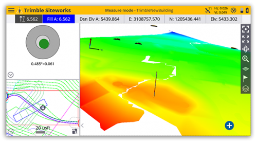
Screenshot: Trimble
Siteworks Software version 1.1 features GNSS tilt-compensation functionality and support for the Android operating system, meaning field workers can use smartphones or tablets. Contractors can run Siteworks on either Windows 10 or Android. Using Trimble Siteworks and a Trimble SPS986 GNSS smart antenna, construction surveyors can take measurements faster and perform more efficient stakeouts. It is designed to shield magnetic interference and can be used effectively anywhere on a construction site. Construction surveyors can capture accurate points without leveling the pole. Three modes support tilt compensation, so contractors can record accurate points while standing, walking or driving the site in a vehicle. Trimble, www.trimble.com
RTK receiver
Multi-band centimeter-accuracy
Photo: Emlid
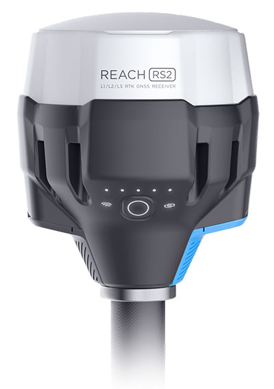
The Reach RS2 is a multi-band GNSS receiver that features a built-in LoRa radio, a 3.5G modem, and a survey app for iOS and Android. The receiver determines a fixed solution in seconds and provides positional accuracy down to several millimeters. It tracks GPS/QZSS (L1, L2), GLONASS (L1, L2), BeiDou (B1, B2), Galileo (E1, E5) and SBAS (L1C/A), and reliably works in RTK mode on distances up to 60 kilometers and 100 kilometers in PPK mode. A multi-feed antenna with multipath rejection offers robust performance even in challenging conditions. RINEX raw data logs are compatible with OPUS, CSRS-PPP, AUSPOS and other PPP services so users can now get centimeter-precise results. Emlid, emlid.com
Mapping
High-speed camera
High resolution for aerial imaging
Photo: Teledyne
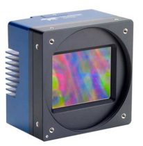
The Falcon 4 is a 86-megapixel ultra-high resolution and high-speed complementary metal oxide semiconductor (CMOS) camera. It offers capabilities for large-area, high-resolution, high-speed imaging. With 86 megapixels at 16 frames per second and a global shutter, the camera offers capabilities for large-area, high-resolution, high-speed imaging. Available in both color and monochrome models, the camera is sensitive into the near-infrared spectrum. The Falcon4’s high resolution and throughput serve a
variety of challenging applications including aerial imaging, reconnaissance, security and surveillance, 3D metrology and flat panel display inspection.
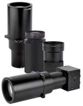
Three new high-performance lenses are designed for high-altitude aerial photography and long-range aerial and ground inspection applications. The 300mm AF, 180mm, and 150mm MK II lenses are designed to enhance the performance and flexibility of Phase One Industrial’s iXM-RS and iXM aerial camera series. Each offers precision imagery, taking advantage of the cameras’ ultra-high resolution backside-illuminated CMOS sensors, to maintain a smaller ground sample distance while flying at higher altitudes.
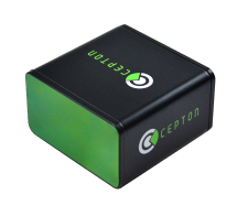
The SORA-P60L, part of Cepton’s SORA family of lidar scanners, is purpose-built to deliver long-range, high-resolution imaging for UAVs. It offers a 400-Hz frame rate, enabling drones to fly faster while maintaining high point-cloud density. With a 550-gram payload, the SORA-P60L prolongs UAV flight time allowing more ground to be covered in a single trip. Cepton’s Micro-Motion Technology faces all lasers downward at all times, providing a dense, uniform point cloud that, in combination with the high scan rate, makes it suitable for fixed-wing and fast-moving rotary-wing UAVs.
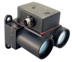
The WASP-200 LRF rangefinder is designed to measure ranges with accuracy and precision. It can be used for precision agriculture applications and as a proximity-to-ground sensor on board small or large unmanned aerial vehicles. It has 1-centimeter resolution and 10-centimeter accuracy, and is compatible with the Collins Aerospace Piccolo (CAN Bus and RS-232) and Pixhawk drivers. The WASP series of rangefinders also feature single-shot laser ranging for fast scanning and moving platforms; programmable burst mode averaging; and an IP-67 option. The rangefinders are suitable for robotics and UAVs, sense and avoid, industrial automation, height and distance measurements, and maritime operations.
The Leica BLK2GO is a small, portable, integrated handheld imaging scanner that offers mobility for scanning complex indoor environments. It combines visualization, lidar and edge-computing technologies to scan in 3D while in motion, allowing users to be more agile and efficient in capturing objects and spaces. Its dual-axis lidar scans up to 700,000 points per second. The handle contains WLAN connectivity, a rechargeable 45-minute battery, data storage for six hours of scans, a USB-C port for fast data transfer, and edge computing. The BLK2GO has a wide range of applications from adaptive reuse projects in the architecture and design industries to location scouting, pre-visualization, and VFX workflows for media and entertainment.
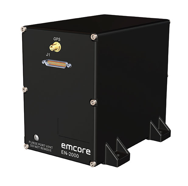
Emcore Corporation has launched the EN-2000 to the Emcore-Orion series of micro-inertial navigation (MINAV) systems.
The new EN-2000 will represent the pinnacle of performance in Emcore navigation systems, and realizes the company’s vision of a closed-loop, solid-state design that will deliver higher performance at lower cost than traditional RLG (ring laser gyroscope) navigation systems.
The EN-2000 expands Emcore’s navigation systems line that also includes the EN-1000 introduced in 2017. The Emcore-Orion series of inertial navigation system (INS) are designed for use in a broad range of defense, aviation and aeronautics applications.
The unit was introduced at the Paris Air Show, held June 17-20 at the Parc des Expositions Paris-le Bourget in Hall 6, Stand #C65.
Today, there is an ever-increasing premium being placed on modern navigation systems for improved size, weight and power (SWaP). Traditional RLG navigation systems placed a premium on accuracy and performance, but not SWaP. Typical RLG and FOG systems are large and heavy, ranging in volume from 330 in3 to 540 in3, weighing 13 to 22 pounds with power requirements of 25 to 38 watts.
Many modern weapon systems are now remotely operated, unmanned or man-portable and may need to operate where GPS is unavailable or denied. The compact EN-2000 is designed for these applications. It puts a premium on accuracy and performance, but also on smaller size, less weight and lower power consumption.
The new Emcore-Orion EN-2000 MINAV is a three-axis design using the company’s proprietary, next-generation solid-state optical transceiver with advanced integrated optics, combined with all new field programmable gate array (FPGA) electronics to deliver stand-alone aircraft-grade navigator performance at one-third the SWaP of legacy or competing systems.
The EN-2000 model comes in two standard versions, an IMU version and a standalone INS configuration. The INS version can gyrocompass to less than 0.7 milliradians and maintain near-GPS-level positional accuracy without the use of a GPS receiver. This makes it suitable for use in GPS-denied environments.
To provide customers with additional flexibility, the unit is also capable of being aided by an external GPS for applications where needed.
The Emcore-Orion EN-2000 is compact and lightweight, weighing less than 7 pounds, with very low power consumption of 10 watts. It can deliver twice the performance of the EN-1000 with the same form factor.
The low SWaP of the EN-2000 makes it a suitable inertial navigation system for unmanned aerial vehicles (UAVs), unmanned underwater vehicles (UUVs), unmanned ground vehicles (UGVs), manned aircraft, rotorcraft and dismounted soldier applications.
“With the introduction of the EN-2000, Emcore can now offer class-leading performance at a fraction of the size, weight and power of competing systems with increased reliability,” said David Faulkner, Emcore vice president and general manager of aerospace and defense. “Emcore’s goal of a true full navigation system that can replace older technology navigation systems in UAVs, UUVs, UGVs, manned aircraft and rotorcraft is fully realized with the introduction of the EN-2000.”
“Our Emcore-Orion series micro navigators improve dramatically on the size and cost of navigation and azimuth sensing equipment by utilizing affordable lightweight sensors that reduce overall system weight and increase accuracy,” added K.K. Wong, Sr., director of fiber optic gyro products for Emcore. “The digital interface is also fully programmable at Emcore’s factory enabling it to directly replace competing units.”