Tag: indoor positioning

  • Locata, A New Constellation: ICD and Live Demos at ION-GNSS 2011

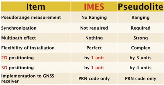
    “GPS can no longer evolve fast enough. Satellite-based systems cannot maintain the speed of development now required for the hyper-fast evolutionary pace of modern applications and devices. For positioning for the future, it has become exceedingly clear that GPS now needs a terrestrial component.” — from a Locata Corporation prospectus

    A large number of companies and engineers have thrown billions of dollars at trying to improve GPS in urban and indoor applications,” states Locata Corporation co-founder Nunzio Gambale. “From a technological perspective, Locata has created something completely new: the capability to autonomously create a GPS-style system on the ground.”

    Members of the GNSS community can see for themselves at Locata’s coming-out party at ION-GNSS 2011, including release of a Locata signal interface control document (ICD). GPS World took an advance look at the technology in a June trial of the demo that all ION attendees can see. This article presents these reports, after an outline of the technology.

    The key to Locata’s positioning system is the signal generated by the Locata transceiver, or LocataLite, to synchronize its time to other LocataLites in a network. Locata creates a network that, according to the company, “is in almost perfect synchronization” without using atomic clocks. Each transmitter dynamically synchronizes with other Locata transmitters using a patented method called Time-Loc. Gambale says that a Locata network currently locks to about 2 nanoseconds.

    Each LocataLite base station has an uninterrupted range of approximately 10 kilometers, with indoor signal penetration similar to that of a mobile phone tower.

    The company emphasizes that its transceivers are not pseudolites, but devices that create TimeLoc synchronization, and thereby enable an autonomous synchronized network that, locally, looks like GPS. The local constellation is under local control, and can therefore be designed for deployment at any power, any frequency, or any density required by an application.

    The networks can scale easily. The term “local” can mean a room or warehouse (100s of m2), a campus or open-cut mine (10s of km2), an airport terminal area with approach and landing routes (100s of km2), or a wide area, range, or city (1,000s of km2)

    Gambale sees markets for Locata’s technology in defense, mining, emergency services, construction, and security. Locata is designed to integrate with existing GPS technology, as simply another constellation. This means an approprieate GPS-Locata receiver can use the satellite signal when outside the range of a Locata network. To a combined GPS-Locata chip, the LocataLite will appear as another satellite.

    The company sold its first Locata network in July 2005. Locata has signed partnership agreements of various kinds with Leica Geosystems and Newmont Corporation (mining), the U.S. Air Force, the Advanced Navigation Technology Center of the Air Force Institute of Technology, and several other firms under non-disclosure terms. There was an initial test deployment at Holloman Air Force Base in May 2008, as a truth reference system spanning a test area of about 52 by 15 kilometers.

    For high-multipath environments such as indoors and warehousing, the company’s latest development is a new antenna called a TimeTenna, which it will demonstrate at ION-GNSS.

    Future research and development will focus on the miniaturization of the Locata receiver. Work has begun on a combined GPS-GLONASS-Locata chip that can be integrated initially into professional and industrial devices, and eventually into consumer devices such as mobile phones.

    Locata plans to work with integrators only, not with end users, making the technology available to qualified partners developing receivers and applications. The ICD is the first step in Locata’s technology rollout.

    #2
    LocataLites awaiting boards. Each LocataLite transmits four PRN signals.

    A Long Time Coming

    Eric Gakstatter, Survey editor

    You may have heard the Locata name pop up over the past several years. It would be in the news, then back underground into stealth mode. About five years ago, I heard some interesting rumors about its technology but I decided not to take them seriously until I saw some real products.

    Two years ago, I sat down with Nunzio Gambale, Locata CEO, at the ION-GNSS conference. At last year’s ION, I talked with him again. At that point, I understood the potential impact of Locata’s technology — if it worked as advertised. I again told myself that before I spent more time on it, I wanted to see a product introduced to the market based on Locata technology. In January of this year, it happened.

    Leica Geosystems introduced its terrestrial GPS Augmentation Network for the mining industry, based on Locata technology. To me, that was a pivotal point. Leica is a reputable company and wouldn’t introduce a product without a thorough vetting.

    I contacted Nunzio and we had further discussions. I wanted to see the technology in action — hard to do since Locata is based in Australia, I’m in Portland, Oregon, and an early installation occurred in South Africa. Fortunately, the company’s need to do a real run-through of its demo on site, prior to ION, meant that I got what I wanted to see, right on my doorstep: a Locata preview at the Oregon Convention Center in June.

    The Technology

    Essentially, Locata has developed a system that is very much GPS-like in that one has a network of reference stations (LocataLites) that interface to an unlimited number of rovers. One major difference is that there is no space segment. It doesn’t need or use satellites. Essentially, each reference station behaves like a satellite on the ground, with the rover moving around inside the polygon formed by the reference stations. The rover position is accurate to the centimeter level.

    The value of the Locata receivers is that they don’t need a clear view of the sky to operate like a GPS receiver does. Yes, that means centimeter-level positioning indoors, where RTK GPS doesn’t work due to satellite visibility constraints, as well as outdoors.

    Sound cool? It is. I saw it working indoors at the Oregon Convention Center. Locata staff set up a large room with Locata reference stations around the perimeter. They had two different rovers: one mounted on a small push cart and the other on a golf cart. We were able to move the rovers around the room freely and view the updated coordinates at 1 Hz intervals (although it’s capable of much faster update rates).

    The Challenges

    The new TimeTenna (see facing page) is large. Today that form factor is required to handle the high-multipath indoor environment. Locata is working on a scaled-down version, although it’s not unreasonable to envision the current model being mounted on a forklift or other vehicle if it was mechanically hardened. The antenna for Locata’s outdoor systems (for mining and other less hostile environments) is much lower profile and similar to a standard GPS antenna.

    The Locata system requires that you manage a network of Locata reference stations. Similar to an RTK network, the Locata system is based on a network of reference stations around the project area. The baseline distances can be quite long (tens of miles), but nevertheless, one must install and manage the network much as one would a GPS RTK network, albeit with much less IT department involvement than a GPS RTK network.

    Lastly, Nunzio Gambale wholeheartedly agrees that Locata’s technology is still developing. He likens it
    to where GPS was in 1990. I tend to agree. The antenna technology needs to reduce in size and the system architecture needs to be vetted for reliability in production environments. But keep in mind that Leica and the U.S. Air Force’s 746 Test Squadron have already bought into Locata’s technology in a big way.

    Although I don’t pretend to have the technical understanding that some of the others in the room possessed during the June demo, I did hear one of the sharper engineers exclaim “genius” at one point, referring to the design.

    It’s certainly worth a close look as Locata’s technology continues to develop and be deployed. I think the day isn’t far away when we will see a system from Locata that will allow a user to transition seamlessly from centimeter-level positioning outdoors using RTK GPS to centimeter-level positioning indoors without breaking a step.

    Now I’m a Believer

    Tony Murfin, Professional OEM editor

    I was invited to Portland in late June to preview an operational system which promises to help GPS in tough signal situations and work well indoors. While Europe, China, India, Japan, and of course Russia are all working to get more operational satellites in space, Locata in Australia has quietly been perfecting its terrestrial navigation system. I say perfecting because skeptics and naysayers have criticized Locata and what was seen as a pseudolite system with a rather lengthy development cycle. But nothing speaks as loudly as an operational system adopted and fielded by Leica Geosystems or a contract with the U.S. Air Force to get people’s attention back in the right place, even though Locata would claim it is only just getting started.

    As I walked into the Portland Convention Center I was certainly apprehensive as to how any GPS-like system could function well within the massive concrete and steel building. When I found the smiling Locata group tucked away in one of the side ballrooms, it didn’t take long before I became a believer. Those wall dividers that allow the Convention Center to reconfigure rooms are apparently referred to as Acousti-Seal 931 Steel Operable Wall panels — yep, perfect multipath reflectors. So to see totally repeatable few centimeter positions in this cavern was not what I was anticipating.

    The ballroom’s carpeted floor had been carefully laser-surveyed with a matrix of 5-meter squares, with a high-precision dot marking each grid intersection. LocataLite stations were set up at each corner and one in the middle at the far end, each with three antennas. A master station at the left corner of the entry wall originated the TimeLoc signal, and on each station one antenna pointed to an adjacent station, over which TimeLoc synchronization was cascaded around the network. This is a key feature of the ground network, allowing it to become fully synchronized and also to be extended or reconfigured at will.

    Of course, when you run your own ground network it helps to be able to run at power levels significantly higher than GPS, so it’s easy for each station to communicate with another, provided they roughly have line-of-sight of each other — kind of like having to actually see a GPS satellite to get it into your GPS position solution. If you have some buildings or bushes or trees to contend with, having higher power available makes things easier, especially if you want an RTK carrier solution.

    The secret to working indoors appears to be the TimeTenna phased-array antenna that Locata demonstrated in the steel-clad ballroom. With this top-hat-like antenna mounted on a wheeled cart along with a receiver and laptop, and positioned over one of those surveyed locations on the carpet, we could easily see that positions within less than 5 centimeters were consistent and solid. As a truth system, the company also had a motorized laser scanner pumping out centimeter-level positions on a parallel measurement system, and it was clear that there was excellent centimeter-level correlation.

    But don’t take my word for it. Come to Portland for the ION-GNSS conference, September 20–23, and see the Locata demo for yourself — you’ll be impressed too!

    Then there is the sole-source U.S. Air Force contract that has Locata updating an existing network to provide independent reference positions over 2,500 square miles of the White Sands Missile Range in New Mexico. The Air Force apparently needs to know how its navigation systems work when it turns on localized GPS jamming. The Locata system is designed to give the Air Force better than the specified <18-centimeter position accuracy in GPS-denied environments.

    In August, Locata cleared the final USAF critical design review milestone for the wide-area White Sands Missile Range deployment. This is clearly a good sign that Air Force wants to continue with the next-generation Locata system. With GPS denied on this range, test vehicles will likely be constrained to inertial-only navigation, but with a LocataLite receiver onboard pumping out high-accuracy position measurements, the Air Force will no doubt have plenty of location data to track dynamic performance under GPS jamming conditions.

    Another application that Locata has been investigating involves airborne trials in Australia, where initial results indicate position accuracy of less than 3 meters at up to 50 kilometers. The trials have involved a ground network with six base stations spread over a roughly square area of 1,500 square kilometers.

    A University of New South Wales test aircraft equipped with precision GPS, inertial reference system, and laser scanner for truth reference use flew to within 3 to 49 kilometers of the reference stations at around 7,000 feet, producing the reported <3-meter code solution. Trials data is still being analyzed to produce a higher accuracy carrier solution, and Locata expects to issue these results at ION.

    Airborne Reference Equipment

    Leica has apparently been working with Locata for some time. The proof-of-concept installation at a 300-foot deep diamond mine in South Africa and a production set-up at a gold mine in Western Australia are going strong.

    The gold-mine installation has now been extended to two pit sites using 15 LocataLite transmitters in total. LocataLite receivers are mounted on vehicles, atop drills and shovels, and all run off the multi-pit Locata network. The mobile units not only carry LocataLite receivers, but also precision Leica GNSS receivers running off side-by-side antennas. As time progresses, the ultimate solution will use integrated multi-constellation/LocataLite receivers: the Locata signals integrated into a combined satellite+terrestrial receiver position solution, using a single integrated antenna.

    It’s easy to envisage such an integrated receiver and antenna where the Locata ground-network signals are used as just another local constellation. The investment to get to such a receiver would of course have to be justified by a whole proliferation of Locata networks. This would seem to be on the way, given the significant progress that Locata has now unveiled.

    Will It Fly — Literally?

    William Shears, aviation engineer

    If you are an aviation satellite navigation enthusiast, you probably noticed this hasn’t been an auspicious year for aviation GNSS or for GNSS applied to any other user segment that needs highly reliable GNSS service. Between personal privacy jammers, instances of accidental interference, and the big chill sent through the community by the LightSquared debacle, many are asking if GNSS is now or ever will be reliable enough to be a sole means of position and time for safety-of-life applications.

    A few years ago, the very idea that ordinary people would want to own GPS jamming devices and that they would be easily obtainable on the Internet would have been considered absurd. Similarly, the idea that the U.S. government would not vigorously protect GPS from interference was just not credible. But here we are in mid-2011 and the vulnerability of GNSS to interference has come home to roost, in several very big ways. This new awareness of the weaknesses of GNSS has led the U.S. Federal Aviation Administration (FAA) and civil aviation authorities of other countries to start rethinking their long-term strategies with respect to satellite navigation.

    Even well before LightSquared crept into the consciousness of the GPS community and then burst forth as the apocalyptic specter that threatens to virtually end the utility of GPS in North America, the FAA had begun a study to consider the need for an alternate positioning, navigation, and timing (APNT) system to support critical aviation needs. The idea being that as the U.S. air traffic management system transitions to become increasingly dependent on management of traffic via four-dimensional trajectories, reversion to a non-trajectory based mode (for example, controllers vectoring aircraft as they do today) would become unfeasible. Hence, airplanes will need a very reliable source of 4D positioning and outages for any extended period of time due to interference, or anything else will be unacceptable. The FAA set about studying what level of performance would be required for a system intended to back up GNSS in the future. Other countries began to follow suit, and whereas the concept of an APNT was obscure a year and a half ago, it has become a significant point of discussion at the International Civil Aviation Administration (ICAO) as well as within various countries, including the United States, Australia, and several in Europe.

    At first blush, the Locata system would seem to be a ready-made solution poised to fulfill aviation’s need for a GNSS backup system. In fact, acting as an independent backup (and/or an augmentation to) GNSS is one of the main motivations in Locata’s development. The technology seems to have promise in meeting the aviation community’s needs for an APNT. Locata is relatively mature technology that has demonstrated accuracies well in excess of what is required of an APNT meant to back up GNSS for enroute, terminal, and non-precision approach operations. Perhaps even precision approach and landing could be supported. Also, the system is very flexible, which suggests that service coverage could be tailored as needed around important airports. The system has significant redundancies built in, including multiple frequencies, multiple antennas for path diversity, and the ability for the network to reconfigure which LocataLite uses which other LocataLite for time synchronization.

    Given this flexibility and redundancy, it should be possible to configure a system that provides highly reliable service where it is needed. Another major advantage of the Locata technology for aviation is the higher signal power level that comes from using terrestrial signals rather than signals from space. In theory, a Locata system would be more robust to interference than space-based GNSS signals.

    Some people are indeed thinking about Locata for aviation use. Locata has conducted flight trials in Australia using a prototype demonstration network of six LocataLites covering an area of more than 1,500 square kilometers around Cooma airport in Australia. Locata has reported code positioning solutions of better than 3 meters at ranges up to 50 kilometers, and will present higher accuracy carrier-phase solutions at ION. The U.S. Air Force is also preparing to use Locata in an aviation environment as an independent truth reference.

    At the ICAO Navigation Systems Panel (NSP) meeting in May 2011, the Australian panel member presented a paper outlining the general need for an APNT. The paper included a description of Locata as an example of what an APNT solution might look like. However, it is interesting that the paper fell short of proposing that the panel pursue Locata as the solution or to suggest that any standardization of a solution for APNT begin immediately. In spite of all the potential advantages discussed above, the Locata system faces a major obstacle before it can practically be used in aviation applications: standardization.

    The first aspect of standardization that is likely to be a huge impediment for Locata (or any other APNT proposal, for that matter) is spectrum. The Locata systems implemented to date have been designed to operate in the 2.4 GHz unlicensed industrial applications band. For Locata to support safety-of-life applications, national aviation authorities will require that an APNT system use spectrum that is properly allocated for use in a safety-critical aeronautical navigation system, that is, spectrum allocated for Aeronautical Route Navigation Services (ARNS). Spectrum allocated as ARNS is afforded special protection from interference. Coordination of services in or near ARNS spectrum is often difficult, time-consuming, and expensive. For example, coordination between civil aviation use of the 108–118 MHz band (used for instrument landing systems, or ILS, and VHF omnidirectional range, or VOR) and FM broadcasting in the 88.1–107.9 MHz band produces real costs and restrictions to be borne by the FM broadcasters. Consequently, any proposal to convert non-ARNS allocated spectrum to ARNS is likely to be met with significant opposition.

    Spectrum is a finite resource, and virtually all spectrum is already in use by someone. So, the reality is that a future APNT will likely have to be implemented in some existing ARNS spectrum, since a new global allocation of spectrum for ARNS is an unlikely proposition.

    The current allocations for ARNS include:

    • 108–118 MHz (ILS/VOR),
    • 960–1215 MHz (DME/Mode-S/ADS-B/SSR/JTIDS/MIDS),
    • 1556–1626 MHz, and
    •  5.1–5.25 GHz.

    All indications are that a Locata system could be could be operated at these frequencies. However, services that already exist in those bands will continue for the foreseeable future. So, to be viable, a Locata system would have to coexist in one of these bands with other existing systems, that is, not interfere with the operation of those other systems. Such coexistence has yet to be demonstrated either by analysis or test.

    After suitable spectrum has been identified, the next major hurdle for Locata is standardization of the signal-in-space to the degree that supports interoperability of equipment produced by different manufacturers in different countries. The Locata ICD released at ION-GNSS 2011 is a good step in the right direction. But for an aviation application, a great deal more would need to be specified, including details about the waveform (spectral mask, out-of-band emissions, and so on), the protocols for producing the signals, and the standard protocols for the application of data to derive a position solution. A clear allocation of responsibility between the ground processing and airborne processing will need to be defined so that system integrity can be analyzed and assured.

    At the international level, such standardization activities can take a decade or more. The length of time required depends on the maturity of the system that is proposed for standardization. The existence of a similar standard, with perhaps a significant user base and operational experience also helps (for example, an IEEE standard or RTCM standards). So, again, the ICD is a good start.

    Beyond the technical aspects of standardization, there are political and institutional aspects that can often be more formidable barriers. Issues with spectrum have already been mentioned. Beyond that, there are issues with intellectual property. Creating aviation standards based on proprietary technology is unpopular although not unprecedented. Proposals for standardization are more likely to be successful the fewer strings, such as licensing agreements or fees, that are attached. This is a challenge since companies that have worked hard to develop cool new technology are often reticent to give away their intellectual property in the name of standardization.

    Given all the barriers, how does new technology ever get implemented in civil aviation? Typically, applications begin in one of two ways:

    • in support of war.
    • in support non-safety related industrial applications.

    The military has historically pioneered many technologies (radar, DME/TACAN, GPS) that would probably not have been developed otherwise. Even after the initial military experience, there is typically a period of time when the new technology is used in a non-safety-critical capacity to support some commercial objective. In the case of Locata, some potential applications would be flight-test position-reference systems, high-precision photogrammetry, high-precision positioning for crop dusting, and any other applications that require a highly robust, high-accuracy position solution in a well-defined region where interoperability and certification are not issues. Those are relatively small niche applications, which may provide some valuable operational experience.

    However, serious movement towards adopting Locata as a standard for APNT is unlikely to happen without the support of at least a couple of large countries. Even a large user base with equipage does not guarantee that countries will adopt the technology or that air navigation service providers will authorize the use of the technology for safety-critical applications. For example, many carriers are equipping with broadband Internet equipment to provide service to the passenger cabin. Yet, there is no serious discussion of using that datalink capability for safety-related communications. Similarly, a very large number of aircraft are equipped with Aircraft Condition and Reporting System (ACARS) datalink, yet use of that system is largely limited to non-essential Airline Operational Communication (AOC) applications.

    So will Locata fly? I believe that is entirely up to Locata and other companies that work with Locata to address the initial military and niche airborne positing markets. Operational experience gained by such early adopters will be critical in laying the groundwork for the support that will be needed from large states like the United States, Australia, China, and those in Europe, if Locata is to be a player in the longer-term international standardization of APNT.

    In the near term, Locata is already serving the aviation community by demonstrating the art of the possible relative to what a ground-based navigation system based on modern technology could be.

  • Opening Up Indoors: Japan’s Indoor Messaging System, IMES

    By Dinesh Manandhar and Hideyuki Torimoto, GNSS Technologies, Inc. Japan

    An indoor messaging system (IMES) has been developed to meet the challenges of indoor and deep indoor positioning, as a system that can be implemented in any device that has a GPS/GNSS receiver without hardware modification. IMES can provide reliable 3D position data with a single transmitter device without performing range calculation.

    The cost of embedding location data in portable electronic devices is so low that universal penetration can be foreseen in the next five years. Roughly 70 percent of the world’s population now uses approximately five billion cell phones. This number has doubled in the last four years. Future growth is expected at the same or even a higher growth rate.

    Due to the emergence of smart phones and location-based services (LBS), mobile phones are used not only for communications but also for many applications related to LBS, entertainment, and games. GPS/GNSS devices are included in mobile phones due to compulsory requirement of E911 and safety-and-rescue services by law in many countries for security and safety.

    Access to map data and value-added services using these map data is getting cheaper and eventually will be freely available. Major service providers like Google, Nokia, and Apple already provide access free of cost, and they increasingly focus on location as a core business construct.

    GPS/GNSS devices were designed to work outdoors, and most GNSS applications are limited to outdoor environments. However, GNSS reliability, availability, and accuracy have led to development of many new and innovative applications that are designed for use in both outdoors and indoors in a seamless fashion. Today, GNSS receivers are integrated in many other devices like mobile phones, navigation systems, personal navigation devices, game devices, security devices, and many LBS-related devices. These devices are increasingly used in indoor environments. Indeed, people generally spend much more time indoors than outdoors. Hence, it is extremely important to have a reliable system that can provide fairly accurate position data even in indoor and deep indoor locations.

    Current GNSS systems do not provide solutions for indoor and deep indoor environment with reliable accuracy of 10–20 meters. New modernized signals such as L5 do provide better position accuracy and better signal reception in indoor areas, but achievable positioning will still vary, and will continue to require more than four visible satellites with some assist data — and still be limited to soft indoors environments such as rooms with glass windows or walls. Limitations remain for hard and deep indoor environments.

    To surmount these obstacles and provide indoor navigation, various technologies such as pseudolites, assisted GPS, wireless networks (Wi-Fi), Bluetooth, RF tagging, and so on have been developed. However, these technologies have their own limitations and are not the most suitable tools for seamless positioning and navigation. Except for pseudolite and A-GPS, they are designed for communication, not for positioning or navigation purposes, but are used for navigation purposes since no other suitable technology exist.

    Pseudolite systems are currently in use for indoor positioning. While technically sound, a system needs at least four signal transmitting units. To cover a large area, it needs many transmitters suitably located and time-synchronized to one other, or their clock errors must be known. Pseudolite systems provide position data based on range calculation from the receiver to a number of transmitters, and this calculation is heavily affected by signal multipath. Table 1 compares IMES and pseudolites.

    IMES-Table1 Source: Dinesh Manandhar and Hideyuki Torimoto, GNSS Technologies, Inc. Japan
    Table 1. Comparison between IMES and pseudolite.

    A-GPS is widely used in mobile phones to compute position data. A-GPS technology includes high-sensitivity signal processing to acquire weak signals and external assistance of data like time, approximate position, and satellite-orbit related parameters. Provision of assistance data requires a communication link between the receiver and the data source, for example, the mobile phone network itself. Thus, A-GPS will not be possible if there is no communication link.

    Normally, A-GPS provides 2D position data. The height data (if 3D output is available) will be highly erroneous. The accuracy of such position data varies from few tens of meters to few hundreds of meters. Also, the position data is heavily affected by signal multipath. Figure 2 compares IMES position and mobile phone position inside an office building. The A-GPS position error is about 300 meters in this case.

    IMES-2-B Source: Dinesh Manandhar and Hideyuki Torimoto, GNSS Technologies, Inc. Japan
    FIGURE 2. Indoor position from high-sensitivity GPS and IMES.

    Wi-Fi is used for indoor positioning in many mobile phone devices. The phone provides position data from a built-in GPS receiver, a Wi-Fi device, cell ID, or a combination of any of these. Recently, position data from Wi-Fi has become popular for indoor as well as outdoor position, since Wi-Fi signals are so freely available. However, using these Wi-Fi signals requires registering the signal power and availability at reference locations. To do this, a huge number of Wi-Fi devices are registered driving around the city. Since these devices are basically installed for communication purposes, they can be relocated, removed, or new devices may be installed without any information to the users or service providers. Thus, continuous maintenance and updating of all these devices are necessary at certain time intervals. The coverage of Wi-Fi devices is not uniform and may vary widely from area to area, affecting position accuracy.

    Telecom service providers are considering the possibilities of seamless positioning technologies. They would like to have one single device that can provide 3D position data both indoors and outdoors, without additional power or cost, and with satisfactory 3D position information. If such a seamless positioning technology is available, it will undoubtedly generate a huge global commercial market. The availability of such technology will also aid development of new applications in location-based services, advertising, marketing, entertainment, and gaming.

    We have conducted research in indoor positioning for the past few years, beginning with pseudolite systems. We have developed IMES to meet the shortcomings of the technologies described earlier for indoor and deep indoor positioning. IMES for a seamless positioning environment can be implemented in any device that has a GPS/GNSS receiver, without hardware modification. IMES can provide satisfactory and reliable 3D position data with a single transmitter device without performing range calculation.

    Table 2 compares IMES with other indoor-position capable devices. IMES can provide the same accuracy even in deep indoor locations, whereas cell tower, A-GPS, and GPS cannot work in such areas. All other systems except IMES provide only 2D position data indoors. The height data from A-GPS is very unreliable and hence cannot be used.

    IMES-Table2 Source: Dinesh Manandhar and Hideyuki Torimoto, GNSS Technologies, Inc. Japan
    Table 2. Comparison of IMES with other indoor positioning systems.

    IMES Concept

    The main concept of IMES is to transmit position and floor ID of the transmitter with the same RF signal as GPS. IMES transmits latitude, longitude, height, and floor ID by replacing the ephemeris and clock data in the navigation mes
    sage of GPS. A single unit of IMES is enough to get the position data, since the position itself is directly transmitted.

    Figure 3 shows the concept of seamless position data using IMES, where the same receiver can be used both indoors and outdoors without interruption. GNSS satellites provide positioning and navigations outdoors, while IMES provides indoor navigation. Since the signal structures of GPS satellites and IMES is the same except for the navigation message contents, the same receiver can be used for both cases. Current GPS receivers will be capable of receiving IMES signals with modification of firmware only to decode the navigation message. Figure 3shows the concept of seamless 3D route guidance.

    IMES-3 Source: Dinesh Manandhar and Hideyuki Torimoto, GNSS Technologies, Inc. Japan
    Figure 3. Seamless 3D route guidance using IMES.

    Signal Properties. The IMES signal is designed much like the GPS signal. It uses the same center frequency as GPS with an offset of +/– 8.2 kHz to minimize the possible interference from IMES to GPS signal. Ten PRN codes from 173 to 182 are assigned for IMES. These codes are provided by the U.S. government. Other signal-related parameters are the same as the GPS L1 C/A code signal. Table 3 shows IMES signal properties with respect to the GPS signal.

     Table 3. IMES signal properties with respect to GPS. Source: Dinesh Manandhar and Hideyuki Torimoto, GNSS Technologies, Inc. Japan
    Table 3. IMES signal properties with respect to GPS.

    IMES has four different types of navigation message. The most significant is Type 1 as shown in Figure 4. It transmits latitude, longitude, height, and floor ID. The transmission of floor ID is a key factor for perfect 3D position data. Other message types are Type 0 (2-D position data with floor ID), Type 3 (short ID), and Type 4 (medium ID).

    Figure 4. IMES Message type 1, 3D position, and floor. Source: Dinesh Manandhar and Hideyuki Torimoto, GNSS Technologies, Inc. Japan
    Figure 4. IMES Message type 1, 3D position, and floor

    Interference Issue

    Since IMES shares the same frequency as GPS L1 band (1575.42 MHz), there is an interference level that IMES may have on GPS signals. This interference has been studied in detail by conducting experiments and simulations. Based on these studies and analysis, various methods have been considered to avoid harmful interference to GPS signal. To avoid such interference, IMES center frequency is shifted by +/– 8.2 Khz from GPS L1 band. This will have the least impact on the GPS L1 band signal. For example, if the IMES signal is –110 dBm (very strong) and the GPS signal is –142 dBm (very weak), the loss of GPS signal (C/N0) due to IMES is less than 2 dB. If the IMES signal is –120 dBm and the GPS signal is –142 dBm, there is no loss of GPS signal (C/N0). Based on this analysis, the IMES transmitter power must be controlled such that the maximum power to the receiver does not exceed –110 dBm at a distance of 3 meters from the transmitter. Figure 5 shows the guideline specified in the QZSS IS document for setting the transmitter effective isotropic radiated power (EIRP)based on location.

    Figure 5. IMES transmitter power setup guideline in QZSS IS document. Source: Dinesh Manandhar and Hideyuki Torimoto, GNSS Technologies, Inc. Japan
    Figure 5. IMES transmitter power setup guideline in QZSS IS document.

    Figure 6 shows the signal propagation loss for transmitter power of –70 dBm for various propagation loss-factor values of n. Figure 7 shows path loss for various transmitter power for the same loss factor, n = 2.5. These graphs shows the maximum power that shall be used to cover an area without exceeding the maximum power level. If a single unit of IMES cannot cover the complete area, then multiple IMES units will be deployed to cover the entire area with suitable power level. These graphs serve as a guideline for setting transmitter power.

    Figure 6. Signal path loss for –70 dBm signal for different path loss coefficient, n. Source: Dinesh Manandhar and Hideyuki Torimoto, GNSS Technologies, Inc. Japan
    Figure 6. Signal path loss for –70 dBm signal for different path loss coefficient, n.
    IMES-7 Source: Dinesh Manandhar and Hideyuki Torimoto, GNSS Technologies, Inc. Japan
    Figure 7. Signal path loss for path loss coefficient, n = 2.5, for different transmitter power levels.

    The signal propagation loss is calculated using the following equation; the gain of transmitter and receiver antennas is considered as unit gain (0 dB).

    IMES-E1 Source: Dinesh Manandhar and Hideyuki Torimoto, GNSS Technologies, Inc. Japan

    Hence, the equation depends on distance from the transmitter, d, and the propagation loss factor, n. The value of n is 2 for free space and increases for areas with objects that obstruct the signal. An office with soft partitions may use n = 2.5. The graphs can be used as a guideline to estimate the transmitter power to cover an area within the allowed power levels.

    Application Areas

    IMES can be used wherever indoor position data is required. It depends upon the application for that particular location as well. For example, an infrastructure-related safety application should have IMES installed at all elevators, escalators, staircases, emergency exits and routes, fire-fighting unit locations, and so on. Here are some of places where IMES might be used:

    • Every room of a building, to provide exact room location.
    • At entrances, exits, elevators, escalators, staircases, public facilities, and corridors for indoor navigation.
    • At every emergency exit for guidance.
    • Along hallways and lobbies at set intervals to guide the user.
    • In front of shops for advertising and information.
    • In sign posts to provide user’s location and guidance.
    • Complement other positioning systems like Wi-Fi, RF Tag, UWB, and so on.
    • As an indoor ground control point for surveying of large and multi-storey buildings.
    • With security cameras to provide accurate position data.
    • In factory production lines for automated control of moving objects.

    Business Perspective

    IMES technology was developed with the guiding concepts of low-cost global implementation and ease of installation and use. Low cost on the transmitter side is achieved by developing large-scale integratin (LSI) chips and IMES installation, setup, and database management tools. At the receiver side it is achieved by design of IMES signal so that existing GPS receivers in mobile phones, PDAs, or any other devices can use IMES by modifying only the firmware. The signal is designed so that it can adapt to other GNSS signals available in the future, for example, Galileo, QZSS, or Compass signals, requiring only firmware modification. Global implementation is made possible by signal design compatibility with existing GPS or GNSS signals. Ease of use is achieved again by signal design: one IMES transmitter can provide 3D position data, including floor information, with reliability and accuracy of a few meters even in deep indoor locations.

    The development of IMES LSI chips (IMES transmitter) will also lead to development of value-added products for many consumer household appliances. For example, the green energy concept produced low-power LED lightbulbs. IMES chips can be installed in LED bulbs at very low additional cost. Similarly, it can be built in many other products like power socket devices, security devices, timing devices, and sensors where position data is also critical. This will provide an opportunity for the manufacturers to provide value-added products to users with indoor positioning devices. Not only electrical products but some construction materials or interior decoration materials like gypsum (dry
    wall) boards can be made with built-in IMES chips. Installation of one piece of wallboard with an IMES built-in chip can provide position data in the room, reducing installation cost while not affecting the interior design of the room.

    Implementation of IMES will also lead to new applications in the field of location-based services and applications where position data are necessary. It can also lead to new applications using IMES as an indoor electronic ground control point (GCP) in large buildings and indoor areas.

    Chip Development. To reduce IMES transmitter cost, the IMES LSI chip has been developed and will be available by the end of the third quarter of 2011. This will reduce overall cost and size, and create platforms to develop value-added products integrating with other devices and systems. The chip is designed for global communications systems like personal handy-phone system (PHS, a mobile phone communication system developed in Japan), CDMA, and GSM. Figure 8 shows a block diagram of the chip transmitter.

    Figure 8. IMES large-scale integration chip block diagram. Source: Dinesh Manandhar and Hideyuki Torimoto, GNSS Technologies, Inc. Japan
    Figure 8. IMES large-scale integration chip block diagram.

    The basic specifications of the LSI chip are: size, 12 x 12 millimeters; power, to be determined; maximum transmit power, –30 dBm or –60 dBm (user selectable); frequency, L1 band, 1575.4282 MHz or 1575.4118 MHz (user selectable); PRN codes, 173–182 (user selectable); signal type, GPS L1C/A, with upgrade capability to other GNSS signals.

    Installation and Management

    An IMES installation, setting, and management system has been developed to facilitate deployment. The main purpose of the system is to provide IMES transmitter position data (latitude, longitude, height) without conducting precision surveys, thus reducing installation, setting, and management costs. The system helps locate optimum locations for IMES transmitter siting, control transmitter EIRP power, set PRN IDs, and assign position data. The system can also use various types of map data sources to generate necessary floor data or indoor maps in 3D. The inputs can be either 3D vector data or 2D raster images, or even paper maps.

    The overall system consists of four sub-systems:

    IMES Setup Tool (ISET). This tool is used to set up the IMES transmitter. It provides two basic functions: to set up signal-related data (setting PRN code, transmitter power, navigation message rate, and so on) and to set up message-related data (position data, floor data, message types and their contents, message sequence, and so on). The R&D version of IMES also allows transmitting some special data for research and development purpose. It is possible to change the preamble value different from GPS, load a different PRN code table than IMES, change the navigation message data rate, generate a BOC(1,1) signal to test L1C-like signals, and change the RF frequency. The setup tool also has user-access management so that only authorized users can change certain sensitive data like PRN code, position data, and transmitter power.

    IMES Database Management Tool (IDBM). This tool simplifies installation and management by providing a necessary database including a building-related database, a service-provider database, a device-related database, other integrated sensors database (if any), and a signal-related database. Since IMES is controlled and managed, guaranteed and authorized services can be provided for dedicated applications. This enhances the reliability of an IMES-based positioning system for infrastructure, security, and safety-related applications.

    3D Mapping Tool (IMAP). This tool, shown in Figure 9, provides a 3D map database for IMES either for implementation or end-user applications. The mapping tool can use 3D vector data (for example, existing DXF files), raster image data, or direct user input. A laser scanning system with CCD camera is used to generate 3D data if existing data is not available. The tool creates walls, windows, doors, ceilings and other smaller objects from the laser data. If data are available in paper drawings, they are scanned to create raster images before digitizing them into vector format.

    IMES-9 Source: Dinesh Manandhar and Hideyuki Torimoto, GNSS Technologies, Inc. Japan
    Figure 9. 3D Map Database Development System.
    Figure 10. Concept of IMES database for implementation, setting and management. Source: Dinesh Manandhar and Hideyuki Torimoto, GNSS Technologies, Inc. Japan
    Figure 10. Concept of IMES database for implementation, setting and management.

    The system will ultimately create a 3D database of a building at floor level that can be linked with external databases. Figure 10 shows the overall concept of the IMES database system that includes both IMES database and 3D map database. The two database systems are linked by a relational database system. Any update in the map database can be reflected into the IMES database.

    Signal Propagation Loss Tool (IPMODEL). This tool simulates the signal level where IMES will be set up. It is necessary to have optimum deployment of the transmitter to cover the area as large as possible within the allowed power level. Although the allowed maximum EIRP power level is –64 dBm for Japan, the approach is always to use the least power possible to cover the area, to avoid any possible harmful interference to other systems as well as to limit the availability of the signal to only the desired area.

    The following equation is used to calculate the signal path loss which is based on Frii’s free-space path-loss model.

    IMES-E2 Source: Dinesh Manandhar and Hideyuki Torimoto, GNSS Technologies, Inc. Japan

    GT is the transmitter antenna gain. The receiver antenna gain is assumed to have unit gain (0 dB) and hence not included in the model.

    L0 is the power loss at 1 m distance and is given by 20 x log10(signal wavelength) — 20 x log10(4*pi).

    N is the path-loss factor, which is 2 for free space, 2.5 for office room with soft partition, and 3.0 for rooms with hard partition.

    Ri is loss due to i number of reflections by objects.

    Pj is loss due to j number of penetrations through objects.

    Figure 11 shows the propagation-loss tool flowchart. It uses 3D map database provided by the 3D mapping tool and database from the database management tool. It also uses antenna gain pattern and material electrical properties to compute the power loss due to reflection and penetration. Figure 12 shows the signal propagation output from the model for a building lobby. Figure 13 and Figure 14 show the output from the propagation loss results from the actual measurement and model output, respectively. The results match within a difference of few dBs.

    IMES-11 Source: Dinesh Manandhar and Hideyuki Torimoto, GNSS Technologies, Inc. Japan
    Figure 11. Path Loss Tool flowchart.
    Figure 12. 3D view of signal power in a building lobby. Source: Dinesh Manandhar and Hideyuki Torimoto, GNSS Technologies, Inc. Japan
    Figure 12. 3D view of signal power in a building lobby.
    Figure 13. Actual signal power measured at different locations in the lobby shown in Figure 12 Source: Dinesh Manandhar and Hideyuki Torimoto, GNSS Technologies, Inc. Japan
    Figure 13. Actual signal power measured at different locations in the lobby shown in Figure 12
    Figure 14. Signal power output from the propagation loss tool at the same location shown in Figure 13 Source: Dinesh Manandhar and Hideyuki Torimoto, GNSS Technologies, Inc. Japan
    Figure 14. Signal power output from the propagation loss tool at the same location shown in Figure 13

    Experiments and Demonstrations

    Experiments and demonstrations have been conducted to validate the IMES concept, uses, and applications. Early experiments validated the
    concept, message design, and interference analysis. Later experiments focused on actual implementation for infrastructure, and social-network and location-based applications. Pilot projects have been conducted in collaboration with the Japanese government to test IMES capabilities for seamless positioning and navigation and for social infrastructure platform.

    The Free Mobility Project in Kobe is the biggest social experiment using IMES for seamless navigation under the sponsorship by the Ministry of Land, Infrastructure, Transport, and Tourism. The project was conducted in an underground shopping mall of Kobe railway station. Shopping mall visitors were asked to participate in the navigation using IMES-capable mobile phones. Most visitors could follow the route they had chosen or find the destination point using the IMES set-up.

    A total of 70 IMES transmitter units were installed at locations including ticket counters, elevator entrances, emergency exits, fire-extinguisher locations, staircases, station entrances, and alleys of the shopping mall. Figure 15 shows a part of the IMES transmitter location map. It covers one of the sections of the shopping mall. Figure 16 shows various locations where IMES transmitter devices were installed. As shown in Figure 17, intelligent 3D route guidance can be performed based on user preference. For example, a user in a wheelchair must be guided by a route that has no staircases, shown by green route in the figure, to reach the destination. A pedestrian can be guided by red route, which is the most direct route to the destination.

    Figure 15. IMES transmitter location map to cover the underground shopping mall in Kobe Station. Source: Dinesh Manandhar and Hideyuki Torimoto, GNSS Technologies, Inc. Japan
    Figure 15. IMES transmitter location map to cover the underground shopping mall in Kobe Station.
    Figure 16. Installation of IMES near the station entrance and emergency exit. Source: Dinesh Manandhar and Hideyuki Torimoto, GNSS Technologies, Inc. Japan
    Figure 16. Installation of IMES near the station entrance and emergency exit.

     Figure 17. Intelligent 3D route guidance using IMES. Source: Dinesh Manandhar and Hideyuki Torimoto, GNSS Technologies, Inc. Japan
    Figure 17. Intelligent 3D route guidance using IMES.
    Figure 18. Seamless navigation by mobile phone using GPS and IMES. Source: Dinesh Manandhar and Hideyuki Torimoto, GNSS Technologies, Inc. Japan
    Figure 18. Seamless navigation by mobile phone using GPS and IMES.

    The distribution of each IMES transmitter is done in such a way that it covers a radial distance of 10 to 20 meters. The deployment density of IMES depends on the location environment. If an IMES device is located near the entrance, the coverage distance will be around 10 meters to minimize transmitted power. IMES devices in deep indoor locations can cover a radial distance of about 15 to 20 meters.

    Commercially available mobile phones with a firmware update for IMES were used to receive the IMES position data. The phones also included the shopping mall and station map including related databases for various applications.

    Conclusions

    IMES can provide reliable and guaranteed 3D position accuracy, including floor information. IMES signal design is done in such a way that it can use existing as well future GPS/GNSS receivers without any hardware modifications. Necessary implementation, setup, and management tools are also developed to facilitate IMES installation and to minimize the cost so that large-scale global implementation is possible. IMES LSI chips are being developed for large-scale implementation. IMES will also help in developing many other location-based applications and services. IMES evaluation kits will soon be available for joint R&D projects.

    IMES technology-related patents have been filed in Japan and many other countries. The basic patents have already been approved in Japan. GNSS Technologies invites academic institutions to participate in joint R&D projects.


    Dinesh Manandhar is a visiting researcher at the University of Tokyo, where he received his Ph. D, and a senior researcher at GNSS Technologies Inc. He is one of the designers of IMES message structure and involved in developing indoor navigation system based on IMES for seamless navigation environment. He can be reached at [email protected].

    Hideyuki Torimoto is the president of GNSS Technologies Inc. Japan. He established Trimble Navigation Japan and Weathernews Inc. in 1986. He also established the Research Forum on Social Infrastructure for Advanced Positioning (NPO) in 2003 and the Satellite Technology Laboratory in Tokyo University of Marine Science in 2004. He served as Satellite Division Member of ION for 2003-04. He can be reached at torimoto @ gnss.co.jp.

  • Innovation: Assisted GPS: A Low-Infrastructure Approach (PDF)

    Innovation: Assisted GPS: A Low-Infrastructure Approach (PDF)

    By Jimmy LaMance, Javier DeSalas, and Jani Järvinen

    Published: March 2002 GPS World

    Have you ever tried to use a GPS receiver indoors? Chances are, unless you were on the top floor of a wood-frame house and using a receiver with ample antenna gain, you couldn’t get a position fix. GPS is a marvelous positioning tool but it does have some weaknesses, one of which is low signal power. And unlike cellular telephones, conventional GPS receivers do not work well, if at all, unless their antennas have a clear view of the sky. Although future GPS satellites will transmit signals with higher power, it will be a decade or more before the current constellation of satellites is fully replaced. In the meantime, how can GPS be used in skyscraper canyons, inside office buildings, and even in underground parking garages? Assisted GPS comes to the rescue! In this month’s column, a team of researchers from the United States and Finland describe their approach for assisted GPS — one which does not require a huge infra- structure investment for service providers.