Tag: INS

  • Royal Navy adopts iXBlue’s inertial technology

    Royal Navy adopts iXBlue’s inertial technology

    The iXBlue's Marins inertial navigation system.
    The iXBlue’s Marins inertial navigation system.

    iXBlue, a navigation and positioning company, is providing 70 Marins M7 to equip 35 Royal Navy major surface ships and submarines as part of the Navigation Compass Programme.

    The decisions to equip both the Queen Elizabeth-Class Aircraft Carriers and the fourth Astute-Class nuclear-power submarine with iXBlue’s Marins inertial navigation system (INS) were the first steps made by the UK Ministry of Defense toward the adoption of iXBlue fiber-optic gyroscope technology.

    The ministry awarded a five-year contract awarded to Lockheed Martin UK, iXBlue’s strategic partner, for iXBlue’s inertial technology.

    The 70 Marins M7 INS will replace the obsolete gyro systems on board the Royal Navy ships which include Type 23 Frigates, Hunt and Sandown Class mine countermeasure vessels and submarines. They will be integrated by Lockheed Martin UK within the compass system installed on board.

    “We conducted a detailed assessment of all available possible partners along with their proposed technologies,” said Robert Kramer, vice president of Lockheed Martin UK – Integrated Systems. “By precisely understanding the Royal Navy expectations and assessing their views on the industry leading suppliers, it clearly appeared that iXBlue’s solutions best fitted the needs in terms of performance, capability and cost.”

    The Marins family of military-grade FOG INS (M3, M5 and M7 models) are the latest additions to iXBlue range of naval products. They offer performances and reliability that meet the requirements of the demanding navies. Marins M7 model offers a drift of less than 1 nautical mile in 72 hours of surface GNSS-denied or submarine-dived navigation.

    “We are very grateful to the Royal Navy for such a decision that demonstrates through a fair and open competition iXBlue’s INS excellence in terms of performance, reliability, lifecycle costs and versatility. This success relies on iXBlue core values: innovation, excellence and a strong commitment to the user,” said Olivier Cervantes, iXBlue vice president for sales and marketing.

    Such a milestone contract opens up bright prospects for iXBlue in the field of military inertial solutions, Cervantes said.

  • VectorNav launches tactical series of IMUs at AUVSI show

    VectorNav launches tactical series of IMUs at AUVSI show

    VectorNav's new Tactical Series includes the VN-110 IMU/AHRS, the VN-210 GPS/INS and the VN-310 dual-antenna GPS/INS.
    VectorNav’s new Tactical Series includes the VN-110 IMU/AHRS, the VN-210 GPS/INS and the VN-310 dual-antenna GPS/INS.

    VectorNav Technologies, manufacturer of embedded navigation solutions, has introduced the Tactical Series, a next generation family of high-performance Inertial Navigation Systems (INS).

    The announcement was made at AUVSI’s Xponential 2016, being held this week in New Orleans, Louisiana.

    Built on a common tactical grade proprietary MEMS inertial sensing core, the Tactical Series includes the VN-110 inertial measurement unit and attitude heading reference system (IMU/AHRS), the VN-210 GPS-aided INS (GPS/INS), and the VN-310 dual-antenna GPS/INS.

    The Tactical Series leverages VectorNav’s navigation algorithm expertise and extensive experience in integrating its industrial series products into a broad range of airborne, marine and ground-based platforms. As a result, the Tactical Series offers the same functionality and features as Industrial Series for integrators of SWaP-C (size, weight, power and cost) constrained manned and unmanned systems.

    Designed and engineered at VectorNav’s headquarters in Dallas, Texas, the Tactical Series takes advantage of the latest developments in solid state MEMS technology to incorporate a 3-axis gyro with <1˚/hr in-run bias stability, leading to an attitude accuracy of 1 to 2 mrad. In addition to the improved IMU core, the Tactical Series enclosure is designed to DO-160G standards and rated IP68 for deployment in harsh and extreme environments.

    “The Tactical Series is the culmination of many years of development effort and collaboration with systems integrators across a broad range of industries,” said VectorNav President John Brashear. “We have combined our digital filtering expertise and experience in solving the challenging navigation requirements of customers worldwide to develop what is truly a next generation navigation solution.”

    The Tactical Series addresses navigation needs for a variety of unmanned applications and will be on display at VectorNav’s booth (#1043) at XPONENTIAL 2016 in New Orleans, May 3-5.

  • PNT Roundup: Inertial, acoustic, lidar, Wi-Fi and beacon news

    Independence, redundancy at sea

    Acoustically aided inertial navigation technology will enable a specialized sea vessel maintain dynamic positioning through GNSS disruptions in challenging environments.

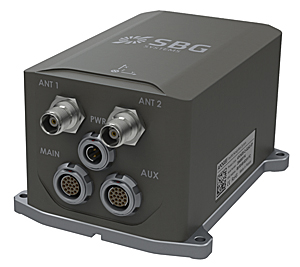
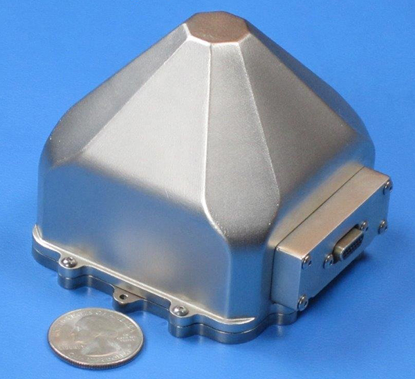
    Sonardyne Inc.‘s dual Ranger 2 Pro DP-INS systems aboard the ultra-light intervention vessel Brandon Bordelon will track remotely operated underwater vehicles (ROVs) during inspection, repair and maintenance activities, providing an independent position reference for the ship’s Marine Technologies Class 2 dynamic positioning system.

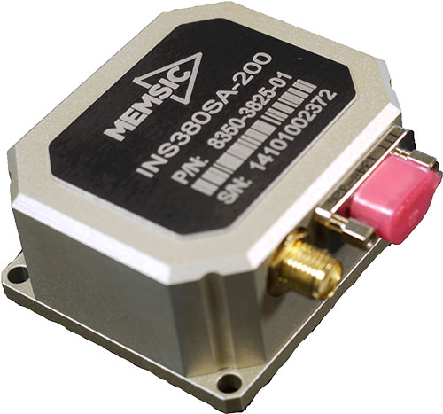
    The Lodestar motion sensing instrument platform (attitude and heading reference system, or AHRS) is tightly integrated with Sonardyne’s acoustic positioning components, providing power and control of surface and subsea transceivers as well as instruments such as Doppler velocity logs. The seamless integration of acoustics and inertial technologies exploits the long-term accuracy and precision characteristics of acoustic positioning with the continuous availability and fast update rate from high-grade inertial sensors.

    Specialized vessels such as this normally rely on GNSS and ultra-short baseline (USBL) acoustics as their primary sources of dynamic positioning reference data. However, a vessel’s station-keeping capability can be compromised if the USBL is affected by noise or thruster aeration and the GNSS signal is simultaneously interrupted. GNSS signal interruption is particularly common around Equatorial regions and during periods of high solar radiation.

    Wideband Acoustic. The integrated acoustic-inertial system addresses this vulnerability, exploiting the long-term accuracy of Sonardyne’s Wideband  2 acoustic signal technology with inertial measurements.

    The resulting navigation output can ride through short-term acoustic disruptions and is completely independent from GNSS.

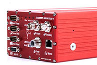
    The equipment includes Sonardyne’s ship-mounted inertial navigation sensor and two HPT 7000 acoustic transceivers. The HPTs have been installed on the Brandon Bordelon through hull deployment poles and are optimized for tracking and dynamic positioning in ultra-deep water.

    The equipment includes three ring laser gyroscopes that measure the angular rate and three accelerometers that measure the specific force of the moving platform. The INS output is low noise and accurate in the short term, but degrades over time. Therefore, it must be seamlessly aided with complimentary acoustic positioning observations.

    Ranger 2 DP-INS uses a tightly coupled integration of range and bearing measurements from seabed transponders to aid the INS and control integration drift.

    Industry effort pushes beyond-LOS UAV flight

    At the International Lidar Mapping Forum in February, two organizations announced an industry consortium to push for removal of barriers to use of drones in long-distance inspections.

    The presentation by Sharper Shape and Edison Electronic Institute made the point that UAVs — specifically, lidar-equipped UAVs — offer potential for more frequent and more affordable inspection and data capture for overhead assets such as power lines. Currently, Federal Aviation Administration (FAA) regulations restrict commercial operations to visual line of sight (VLOS). The EEI Sharper Utility project will advocate for beyond visual line of sight (BVLOS) flights.

    The presentation explored such issues as:

    • Types of information obtainable during UAV inspections and how that information can be used to improve infrastructure and asset management programs.
    • How UAVs provide a cost-effective alternative to traditional inspection methods, and the critical factors contributing to cost-efficiency.
    • Why industry-wide coordinated effort is required to institute change.
    • Steps and the key principles to enable commercial-scale drone operations for the electricity industry.
    • Identification of stakeholders and the regulators.
    • The anticipated date of permitted BVLOS drone flights in U.S. utility inspections.

    The Eyes of Texas. In related news, Xcel Energy announced a UAV flight research and development mission that traveled beyond the operator’s line of sight during survey of a transmission line in the Canadian River Breaks region north of Amarillo, Texas, in early February. Two contractors piloted the lidar-equipped Vapor 55 drone. Xcel began using unmanned aircraft to visually inspect substations in 2015, and is the first utility to receive and use the FAA’s certificate of authorization to perform a mission for research and development purposes beyond visual line of sight.

    Xcel Energy inspects 320,000 miles of electricity and natural gas infrastructure, including more than 1,000 substations, gas regulator stations and dozens of major power plants in eight states. GPS World will carry further news of this flight in a subsequent issue.

    Indoor Nav at Vast Mobile World Congress

    Add Infrared Aiding in Retail Show

    A scalable indoor positioning hybrid technology from Pole Star of Toulouse, France, combining GPS, Wi-Fi, Bluetooth Low Energy beacons, and motion sensors, and MOCA of Barcelona, Spain, with a location-based mobile engagement platform, provided show navigation, guidance and tracking for the GSMA Mobile World Congress in February.

    The joint solution delivers three service levels that combine users’ geolocation with other data to provide expanded contextualized messages. As many as 95,000 show attendees — iOs and Android users alike — were guided through the 240,000 square meters (2.6 million square feet) of the FiraBarcelona, receiving personalized notifications from an intelligent recommendation system based on proximity.

    Using geofencing, the 2,200 exhibitors could interact with attendees and attract them to theirs booths. Finally, indoor location analytics enabled the event organizers to visualize and correlate behavior and preferences of attendees.

    Infrared. Pole Star also announced at the Retail Big Show in New York in January that it is integrating its NAO Campus indoor positioning technology with the Pricer Product Location solution based on Infrared trilateration. The combination will enable shoppers, once inside a store, to optimize their shopping route and be guided to the products and promotions they are looking for. Hyper-local targeting for shoppers and Indoor location-based analytics for retailers and brands are among the benefits touted.

    Pricer, based in Uppsala, Sweden, offers in-store automated product positioning using infrared (IR) communication, combined with tracking algorithms to calculate the position of its electronic shelf labels (ESLs). A typical Pricer label response signal is seen by multiple points in the communication network reading different signal strengths depending on the distance from the label.

    Automated in-store product positioning in retail is a “holy grail” for retailers, according to the company. By mapping in real time where the products are placed on the sales floor using the IR technology, companies can engage customers in the aisles, help customers find products and manage product placement compliance.

  • Sonardyne dynamic positioning fills in for GNSS disruptions

    Bordelon Marine, providers of vessel services to operators in the Gulf of Mexico and around the world, has selected acoustically aided inertial navigation technology from Sonardyne Inc., Houston, for its new ultra-light intervention vessel (ULIV) Brandon Bordelon.

    The dual Ranger 2 Pro DP-INS systems, the highest specification available, will be used to track remotely operated underwater vehicles (ROVs) during inspection, repair and maintenance activities and provide an independent position reference for the vessel’s Marine Technologies Class 2 dynamic positioning system.

    Specialized vessels such as the Brandon Bordelon conventionally rely on GNSS and ultra-short baseline (USBL) acoustics  as their primary sources of dynamic positioning reference data.

    However, a vessel’s station-keeping capability can be compromised in the event that the USBL is affected by thruster aeration or noise and the GNSS signal is simultaneously interrupted. The latter is particularly common around equatorial regions and during periods of high solar radiation.

    Sonardyne’s Ranger 2 Pro DP-INS system addresses this operational vulnerability. It aids vessel positioning by exploiting the long term accuracy of Sonardyne’s Wideband 2 acoustic signal technology with high integrity, high update rate inertial measurements. The resulting navigation output has the ability to ride-through short-term acoustic disruptions and is completely independent from GNSS.

    The Brandon Bordelon was delivered at the end of 2015 and is under a 60-day contract with Tidewater Subsea. Designed to support complex inspection, repair and maintenance operations, the vessel features a high-capacity deep-water crane, infrastructure for two work-class ROVs and a large, reconfigurable back-deck area.

    In addition to the system’s deep water positioning performance and safety benefits, DP-INS has been proven to deliver valuable time and cost savings for vessel owners. It does not need a full seabed array of transponders to be installed and calibrated before subsea operations can commence.

    For most subsea tasks, positioning specifications can be met with only one or two transponders deployed on the seabed. Additionally, as the system needs only occasional aiding from the acoustics, transponder battery life is substantially increased and the need to task an ROV to deploy and recover transponders for servicing is reduced.

    The equipment supplied to Bordelon Marine included Sonardyne’s ship-mounted inertial navigation sensor and two HPT 7000 acoustic transceivers. The HPTs have been installed on the Brandon Bordelon through-hull deployment poles and are optimised for tracking and dynamic positioning in ultra-deep water.

    Wes Bordelon, President/CEO Bordelon Marine said, “Equipping the Brandon Bordelon with Sonardyne’s Ranger 2 DP-INS, reflects our commitment to providing high-tech, high-spec equipment on our fit-for-purpose Stingray vessels and ensuring our fleet is safe, efficient and cost-effective.

    “Ranger 2 DP-INS is a mature, field proven technology that addresses operators’ need for a robust, independent DP reference that provides an update rate and accuracy on par with GNSS,” said Ralph Gall, Technical Sales Manager at Sonardyne in Houston. He added, “The Brandon Bordelon joins a significant fleet of vessels which depend upon our acoustically-aided inertial technology for safer and more efficient dynamic positioning operations.”

  • KVH introduces FOG-based GNSS inertial nav for unmanned applications

    KVH’s new GEO-FOG 3D inertial navigation system (INS) continuously provides extremely accurate measurements that keep applications operating in challenging conditions.
    KVH’s new GEO-FOG 3D inertial navigation system (INS) continuously provides extremely accurate measurements that keep applications operating in challenging conditions. (Image: KVH)

    KVH Industries has introduced the GEO-FOG 3D inertial navigation system (INS). The new product offers roll, pitch and heading accuracies of .05 degrees for demanding applications in unmanned, autonomous and manned aerial, ground, marine and subsurface platforms, such as subsea remotely operated vehicles or mining systems.

    The GEO-FOG 3D is based on the company’s high-performance fiber optic gyro (FOG) technology combined with centimeter-level precision RTK GNSS receivers and advanced sensor fusion algorithms. The result is a solution that continuously provides fast, ultra-accurate position, velocity and attitude measurements that keep applications operating no matter how challenging the conditions, according to KVH Industries.

    The core inertial sensor for the new system is KVH’s 1750 IMU, an inertial measurement unit incorporating three axes of KVH’s DSP-1750 FOG — a high-performance fiber optic gyro — with three axes of advanced accelerometer technology. The 1750 IMU is then fully integrated with a GNSS receiver and a three-axis magnetometer, a barometric pressure sensor and a triple frequency RTK GNSS receiver to deliver reliable, real-time, centimeter-level positioning and orientation measurements.

    The system’s sensor fusion algorithms automatically switch from loosely to tightly coupled filtering for improved performance under poor GNSS signal conditions. The system also offers high-speed update rates and rapid north-seeking gyrocompass capabilities for high-accuracy heading in environments when magnetometers and GNSS-aided heading cannot be used.

    The GEO-FOG 3D Dual inertial navigation system (INS) is designed for applications that require heading at system startup or in low dynamic conditions.
    The GEO-FOG 3D Dual inertial navigation system (INS) is designed for applications that require heading at system startup or in low dynamic conditions. (Image: KVH)

    KVH has also introduced a variant, the GEO-FOG 3D Dual, an INS and attitude and heading reference system (AHRS). This product features two GNSS antennas on a fixed RTK baseline that offers the same reliability and performance levels as the GEO-FOG 3D, with increased heading, pitch, and roll accuracy for static and dynamic applications where single antenna systems can be problematic. The GEO-FOG 3D Dual is a superior choice for applications that require heading at system startup or in low dynamic conditions.

    “KVH’s GEO-FOG 3D and GEO-FOG 3D Dual provide exceptional accuracy and outstanding performance in a single, small package (less than 1.6 pounds), at price points never previously achieved in the industry,” said Jay Napoli, KVH’s FOG/OEM vice president. “And, because KVH controls the entire design and production process, from creating its own optical fiber to packaging its FOGs together with other sensors for advanced applications, these new products — and all of our open-loop FOGs, IMUs and INSs — offer outstanding accuracy and excellent durability at a lower cost than competing systems.”

    Reliable, high-accuracy navigation and control are essential to unmanned, autonomous and manned platforms that must operate in conditions that include magnetic interference and the absence of reliable satellite navigation data. The integrated FOG, GNSS and sensor fusion technologies allow the GEO-FOG 3D and GEO-FOG 3D Dual to achieve performance levels that are beyond typical INS- or MEMS-based solutions.

    Both the GEO-FOG 3D and GEO-FOG 3D Dual are designed to support current and future satellite navigation systems including GPS, GLONASS, Galileo and BeiDou. Both systems offer data rates up to 1000 Hz, and the ability to output data over a high-speed RS-422 interface or RS-232 interface, which ensures the systems can be easily and readily integrated in a wide range of platforms.

  • OxTS Creates Locata + INS System

    OxTS Creates Locata + INS System

    The Inertial+ by OxTS improves measurements from a GPS receiver.
    The Inertial+ by OxTS improves measurements from a GPS receiver.

    OxTS has successfully integrated a Locata receiver with its Inertial+ to create the first Locata+INS device, according to both companies. The device is capable of achieving centimeter-level accuracy where GPS systems fail.

    The Inertial+ series, first developed in 2008, was designed for users who had an external GNSS receiver already, but still wanted to gain the benefits of an inertial system. The company has been able to combine OxTS’ Kalman filter and expertise in GNSS/IMU integration with its existing systems, meaning the user doesn’t have to pay for survey-grade integrated receivers.

    Over the years, a number of popular GNSS receivers have been integrated with the Inertial+ to keep up to date with the market and make sure customers with the latest models can take advantage of the benefits the Inertial+ brings, OxTS said. Now, the Inertial+ has expanded from GNSS receivers and become the first inertial navigation system to integrate a Locata receiver, combining the many benefits of both systems, the companies said.

    Locata is an innovative positioning system designed to complement rather than replace GPS, by addressing the issues and shortfalls of GNSS. As always, the Inertial+ allows Locata users to take advantage of their existing technology while enjoying the extra layer of measurements an aided-inertial navigation system brings.

    Locata enables positioning in environments where GPS is either marginal or unavailable. Instead of using signals from satellites, a network of ground-based Locata transmitters (known as a LocataNet) can be set up around any specified local area. The LocataNet transmits GPS-like signals that allow any Locata receiver in the network to accurately calculate its position and time. Unlike GPS, where signals are too weak to penetrate into buildings, Locata’s signals are very powerful — more than one million times more powerful than GPS.

    Additionally, with a locally based system (rather than a global satellite system), a user gains the benefit of having total control over both the reliability and quality of positioning solutions within the LocataNet coverage area. Locata systems are being sold today in many markets where GPS is unusable or unreliable, such as inside warehouses, on dockyards, in open-pit mines, for UAVs in urban areas, and for military uses where GPS is being actively denied by an adversary.

    By combining the technologies of an inertial navigation system and a local positioning system, users have access to an extremely reliable and robust navigation solution, the companies said. Locata positioning data is fused with the IMU data in the Inertial+ with OxTS’ custom Kalman filter, creating a full 3D navigation solution with precise position, orientation, heading, velocity and acceleration measurements.

  • MEMSIC Launches Inertial System with GPS

    MEMSIC Launches Inertial System with GPS

    The MEMSIC INS380SA.
    The MEMSIC INS380SA.

    MEMSIC has launched its latest inertial system, the INS380 — a complete inertial navigation system with a built-in 48-channel GPS receiver. The INS380 is part of a portfolio of inertial systems enabled with MEMSIC’s SmartSensing technology for a broad range of precision-motion sensing applications.

    The MEMSIC portfolio consists of inertial measurement units (IMU), vertical gyros (VG), attitude and heading reference systems (AHRS), inertial navigation systems (INS) and tilt measurement systems in a variety of packages for system designers and end-equipment manufacturers.

    The SmartSensing technology enables a turnkey system with better than 0.01 m/s velocity measurement accuracy. The integrated 3-axis magnetometer allows for accurate operation when the GPS signal is lost or when the vehicle comes to a stop. SmartSensing provides users with sensor fusion and performance in critical motion sensing applications.

    SmartSensing combines enhanced and patented Kalman-based algorithm with proprietary temperature, motion and alignment calibration for consistent and high-accuracy performance over a wide range of extreme operating conditions. Applications include unmanned ground and aerial vehicles, platform stabilization, avionics, precision agriculture, construction and more.

    INS380SA-400 EVALKIT is available for evaluation and ships completer with an INS380 unit along with necessary accessories for quick installation. Designers can evaluate and configure the system using MEMSIC’s NavView Software, available for download.

  • SBG Systems Selects Septentrio AsteRx4 for Apogee Series

    SBG Systems, a manufacturer of inertial navigation systems (INS), has selected the Septentrio AsteRx4 OEM GNSS receiver to equip its Apogee product line. The announcement was made during Ocean Business 2015, held April 14-16 in Southampton, England.

    SBG Systems' Apogee-N.
    SBG Systems’ Apogee-D

    “We are delighted that SBG Systems — a respected specialist in designing INS/GNSS — endorses our newly released GNSS receiver for its performance,” said, Laurent Le Thuaut, business development manager at Septentrio. “The SBG products are recognized amongst the preferred choice for accurate MEMS-based INS and we are extremely proud that our technology is included in their top of the line.”

    Apogee is a new product line of high-accuracy inertial navigation systems based on robust and cost-effective MEMS technology. The INS/GNSS solution combines the latest generation of MEMS sensors and the OEM version of the AsteRx4, a newly introduced high-precision GNSS receiver from Septentrio. The Apogee series is especially suited for applications such as hydrography, mobile mapping and aerial survey where survey-grade positioning measurements are required.

    AsteRx4
    AsteRx4 OEM

    The AsteRx4 OEM is a multi-frequency and multi-constellation dual antenna receiver that incorporates the latest innovative GNSS tracking and positioning algorithms from Septentrio. The AsteRx4 is scalable to one centimeter and integrates the entire suite of GNSS+ algorithms proposed by Septentrio to maintain tracking during heavy vibration of machines. This assures position accuracy under difficult ionosphere conditions and mitigates or rejects intentional or unintentional interference with GNSS signals.

    “The compact design and the practical and well-designed interface of the AsteRx4 allowed a seamless and an easy integration into our solutions” said Raphaël Siryani, chief marketing & sales officer of SBG Systems. “The AsteRx4 largely contributes to the robust and accurate heading as well as the reduced power consumption of the INS/GNSS Apogee products.”

    Both the AsteRx4 OEM receiver and the Apogee INS/GNSS are on display at booth No. W40 (Septentrio) and booth E5c (SBG Systems) at Ocean Business.

  • SBG Systems Releases Apogee Series of MEMS Inertial Navigation Systems

    SBG Systems Releases Apogee Series of MEMS Inertial Navigation Systems

    Source: GPS world staff
    SBG Systems’ Apogee-N.

    SBG Systems has released the Apogee Series, its most accurate inertial navigation systems based on robust and cost-effective MEMS technology. The INS/GNSS integrates the latest generation of MEMS sensors and a tri-frequency GNSS receiver. Apogee achieves 0.008° in roll and pitch in real-time and 0.005° in post-processing. With two antennas, it delivers a robust and accurate heading.

    Four models compose the Apogee line.

    • The Apogee-A provides only orientation data.
    • The Apogee-N additionally embeds a GNSS receiver; it is a compact solution with one antenna for land and aerial applications.
    • The Apogee-D embeds a dual-antenna GNSS receiver for accurate heading under low dynamics conditions.
    • The Apogee-E delivers navigation data when connected to an external GNSS receiver or to the SplitBox with integrated GNSS.

    Mobile Mapping. Apogee can be precisely synchronized with LiDAR equipment because of a UTC time-stamping accurate to 1 microsecond. This integrated INS/GNSS provides optimal position in multipath environment or during GNSS outages, thanks to a tight GNSS integration and the continuous fusion of inertial and odometer data. To get the required positioning accuracy, Apogee supports RTK and Precise Point Positioning services (Omnistar, Terrastar, and more).

    Aerial Mapping and Remote Sensing. With very low noise gyroscopes, low latency, and high resistance to vibrations, the Apogee allows aerial surveys by plane or helicopter. It provides real-time orientation and position data with direct fusion of inertial and GNSS information. Compact, lightweight and low power, the Apogee is easy to install, and has an embedded web interface for configuration.

    Post-processing. Orientation and position data can be recorded in the Apogee data logger. At the office, the user imports data in the post-processing software. This tool gives access to several RTK networks and reference station offline data (such as VRS and CORS.) Additionally, it enhances orientation and position accuracy by a complete “backward/forward” calculation.

    “SBG Systems manufactures inertial systems from the concept to the production. The Apogee benefits from our high level of expertise in integrated design, IMU calibration, testing, and filtering,” said Alexis Guinamard, CTO of SBG Systems.

    All models are available for order. Below is a promotional video with more information.

  • Sensors in Motion Launches MEMS-Based Inertial Nav System

    Sensors in Motion Launches MEMS-Based Inertial Nav System

    SIM-MEMs-based-Inertial-Navigation-System-W
    Photo: SIM

    Sensors in Motion (SIM) has introduced  a MEMS (micro-electro-mechanical) navigation-grade inertial system (INS) that it says could transform the $8 billion/year inertial market with new products by offering price and performance specifications better than those currently available.

    The first INS devices have been delivered to the Army CERDEC Night Vision Electronic Sensors Directorate (NVESD).

    SIM, a spinout from NASA’s Jet Propulsion Laboratory and California Institute of Technology, is developing a family of high-accuracy MEMS gyroscopes, accelerometers and inertial measurement unit ( IMU) solutions. It says it has perfected unique MEMS structures using volume silicon wafer processing techniques to produce gyroscopes having ARW (angle random walk) less than 0.0035 degree/root-hour and bias instability less than 0.01 degree/hour with extraordinary vibration and temperature immunity, a performance comparable to ring laser (RLG) and fiber optic (FOG) gyros that are 20 times larger and 100 times more expensive.

    These features are mandatory for numerous applications where location is not available from GPS or vehicle position accuracy is required including autonomous vehicles, drones, mining asset tracking, dead reckoning, agricultural seed placement, oil and gas directional drilling, self-driving autos, firefighter navigation, optical image stabilization, industrial equipment azimuth, aerospace and defense products and most GPS-denied environments, in addition to new applications.

    Current devices would have a vehicle position off as much as 1 foot per second at 45 miles per hour.

    “We see this technology opening an additional $2B sensor market needing size, weight, power, cost and performance that does not exist today. “ said David Smukowski, CEO of SIM.

    With adequate resources the company says further performance gains are possible, even while shrinking the devices smaller for better economics.

  • Sparton Introduces GPS-Assisted Inertial Navigation System

    GAINS-10
    photo: Sparton

    Sparton Corporation has announced that Sparton Navigation and Exploration will introduce its GPS/ GNSS Assisted Inertial Navigation System, GAINS-10, at AUVSI Unmanned Systems 2014.

    GAINS-10 provides accurate inertial navigation in the presence of mechanical shock, transient platform vibrations and extreme magnetic interference. It features high speed, synchronous sampling of all inertial systems combined with high rate coning and sculling compensation and is fully calibrated across temperature.

    “The GAINS-10 delivers precise performance in complex environments,” said Jim Lackemacher, Group vice president of Sparton’s Defense & Security Engineered Products. “Sparton’s GAINS-10 provides flexible integration options and platform customization.”

    Features of GAINS-10:

    • Advanced EKF implementation coupled with Sparton’s proprietary AdaptNav sensor fusion algorithms
    • Multi-GNSS receiver module using multiple satellite constellations in parallel
    • 10 DOF High Performance Inertial Measurement Unit
    • Enhanced MEMS sensing technology (3-axis magnetic, 3-axis acceleration, 3-axis gyro and barometer)
    • High-speed synchronous sampling of all inertial sensors
    • Customizable on-board high speed digital filtering
    • Sculling and coning compensation
    • High-speed data logging capability to off-board uSD card
    • Ruggedized, shockproof design, with proprietary seals that allow barometric pressure sensing combined with IP67 performance
    • Low power consumption with power management functionality (Sleep Mode)
    • Interface to external GPS receiver
    • External data interface via Multi-GPIO connectivity
    • Powerful user programmable customizations via NorthTek(TM) Forth interpreter

    Sparton AUVSI 2014 Events Schedule: Sparton Navigation and Exploration will be featured at the “Beyond the Booth” showcase Wednesday, May 14th at 11:30am (EDT).

    Throughout the AUVSI show, Sparton will host in-booth presentations along with live demonstrations.

  • New Report on Global Military GPS/GNSS Market Looks at Next Decade

    Reportstack has announced a new report on The Global Military GPS/GNSS Market 2013-2023.  This report offers the reader detailed analysis of the global military GPS/GNSS  market over the next 10 years, alongside potential market opportunities to enter the industry, using detailed market size forecasts, Reportstack said.

    A satellite navigation system provides GPS positioning from a global perspective, and is therefore of utmost importance for modern-day military operations, which rely on accurate real-time data on hostile forces in order to carry out precision attacks, Reportstack said. It is here that GPS/GNSS devices assume an important role, as they are imperative to transfer signals from these satellites back to earth.

    The U.S. is the highest spender on military GPS/GNSS navigation, and is responsible for 42.9% of the global military GNSS devices market. Others major spenders in this sector include Russia, the UK, China and India. In July 2013, India launched the IRNSS-1A, the first of seven satellite constellation to be deployed under the Indian Regional Navigation Satellite System (IRNSS) program to be completed between 2015-2016. And China’s BeiDou is scheduled to be operational by 2020.

    Another factor driving the market is the integration of satellite navigation technology with other navigation systems, such as the inertial navigation system (INS) and gyro, as GPS devices are to be used in order to decipher data correctly, Reportstack said.

    The increasing demand for satellite navigation and communications is driven primarily by the desire of militaries to monitor more areas and derive accurate information by a range of GNSS receivers/sensors in the shortest time possible. Major military aircraft and helicopters are dependent on GPS embedded INS systems for effective navigation. Similarly, naval vessels and guided munitions are increasingly relying on the collaboration of laser, gyro, INS, and satellite navigation technologies to derive accurate real time data.

    Furthermore, it has been observed that the usage of standard positioning services/open service receivers, which use unencrypted signal for non-combat purposes has increased, and is expected to drive demand and encourage expenditure, Reportstack said. The military GPS/GNSS technology is expanding its horizon beyond the basic characteristics of navigation and tracking. The use of GPS, in conjunction with a number of software applications, has expanded its use in military operations. A number of new technologies are now embedded with GPS receivers to produce a more sophisticated military tool.

    Recently, a Swiss-based company developed a device called GPS Log Book based on u-blox technology. The new device has extended the scope of GPS technology to the administrative side of military operations. It provides an easy way for military drivers to automatically keep an accurate travel log book which can be securely accessed later from anywhere via a web interface. Information logged includes route, speed, and distance traveled. It also keeps a close record of fuel used by the vehicle, based on the distance traveled at various speed levels.

    The advent of Differential GPS (DGPS), an enhancement to GPS, which provides improved location accuracy, from the 15-meter nominal GPS accuracy to approximately 10 cm, has further expanded the scope of GPS in missile technology. The intercontinental ballistic missiles, which are capable of hitting targets across thousands of miles navigation, use inertial navigation with DGPS receivers. The advent of DGPS is expected to be one of the most significant steps in accurate missile targeting for militaries across regions.

    The companies mentioned in this report are Northrop Grumman, Raytheon, Rockwell Collins , Lockheed Martin, ITT Exelis, Thales, and BAE Systems. More details and table of contents about this report can be found by visiting The Global Military GPS/GNSS Market 2013-2023 report.