Tag: INS

  • SBG Systems Releases Ekinox Land Solution

    SBG Systems Releases Ekinox Land Solution

    The Ekinox Land Solution by SBG Systems.
    The Ekinox Land Solution by SBG Systems.

    At ION GNSS+ this week, SBG Systems announced the release of the Ekinox Land Solution, an all-in-one solution combining the cost-effective inertial navigation system with an odometer, and a GNSS RTK reference station for smooth positioning in land applications. GPS positioning in urban canyons, forests, or tunnels has always been challenging. By taking the best of these complementary technologies, Ekinox Land Solution provides reliable positioning in an affordable package, the company said.

    SBG Systems is exhibiting the system Wednesday through Friday at Booth 519/521 at ION GNSS+ in the Nashville Convention Center.

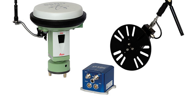
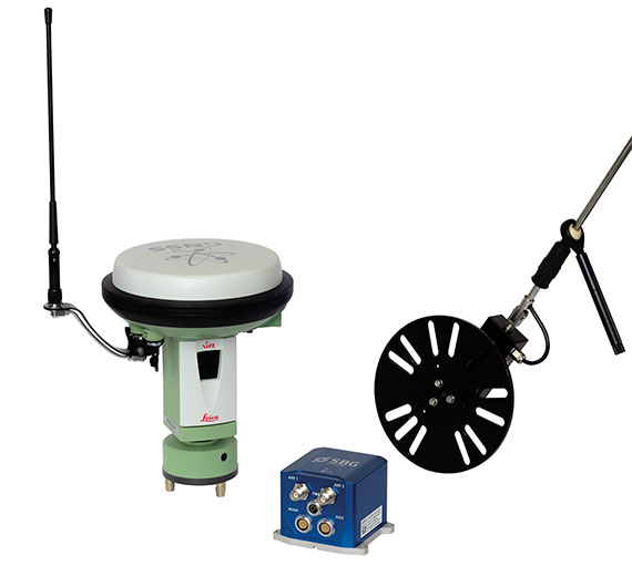
    The combination of the Ekinox inertial navigation system with complementary technologies such as wheel-speed sensor (DMI) and RTK GNSS is the key to providing smooth vehicle positioning, even during GPS outages, SBG Systems said. To save users and integrators both time and money, the best equipment has been tested and selected to build a cost-effective and all-in-one package — Ekinox Land Solution.

    Ekinox Land Solution is an integrated package built from the Ekinox Series, a range of inertial navigation systems based on robust and cost-effective MEMS technology. Mounted on a vehicle, Ekinox Land Solution provides real-time roll, pitch, and true heading (0.05° accuracy) while delivering a smooth position (2 cm). Data is output at 200 Hz and recorded in an 8-GB datalogger. Post-processing software is offered to increase attitude accuracy (up to 0.02°).

    Ekinox Land Solution is designed to answer the growing need of vehicle real-time positioning, imagery sensor triggering, and data georeferencing at an affordable price. Examples of applications include mobile mapping, machine control, car motion analysis, and unmanned ground vehicle navigation.

    The Ekinox series includes the Ekinox-A, and Attitude and Heading Reference System; the Ekinox-E, an Inertial Navigation System (INS) whose position feature depends on aiding equipment; the Ekinox-N, an INS with an embedded L1/L2 GNSS receiver; and the Ekinox-D, an INS with an integrated Dual Antenna GNSS receiver.

    SBG Systems is a French supplier of MEMS-based inertial motion sensing solutions. The company provides a wide range of inertial solutions from miniature to high accuracy. Combined with calibration techniques and advanced embedded algorithms, SBG Systems products are designed for defense, industrial and research projects, such as unmanned vehicle control, antenna tracking, camera stabilization, and surveying applications.


  • VectorNav to Supply VN-200 GPS/INS to Troll Systems

    VectorNav to Supply VN-200 GPS/INS to Troll Systems


    Vector Technologies VN-200
    VectorNav Technologies VN-200.

    VectorNav Technologies, a provider of inertial navigation solutions for the industrial and military markets, announced Tuesday that it will supply its VN-200 GPS-aided inertial navigation system (GPS/INS) for use in Troll Systems’ SkyLink MINI II directional antennas. The next-generation version of the SkyLink antenna provides Troll Systems’ customers with a lower-cost and easier to integrate update to its existing SkyLink antenna solution, the company said.

    VectorNav made the announcement at AUVSI’s Unmanned Systems North America 2013 Conference, August 12-15, in Washington, D.C., where both companies are exhibiting.

    About the size of a postage stamp, VectorNav’s VN-200 is a calibrated MEMS-based GPS/INS that provides a coupled position, velocity, and attitude solution suitable for a wide range of static and dynamic operating conditions. The VN-200 incorporates an onboard high sensitivity 50-channel u-blox GPS module. The microprocessor runs an aerospace-grade Kalman filter algorithm at a rate of up to 200 hertz and provides accuracies better than 0.25 degrees in pitch and roll and 0.75 degrees in heading. The upgraded version of Troll Systems’ SkyLink MINI II antenna features a deeply embedded, surface mount VN-200 GPS/INS module that delivers control and stabilization for the gimbaled antenna system.

    The only airborne directional antennas to pass DO-160 testing, Troll Systems’ SkyLink antennas are compact, lightweight and steerable airborne tracking antennas that equip its users with an industry leading air-to-ground data-link solution. The upgraded SkyLink antenna system featuring the VN-200 GPS/INS enables Troll’s customers to eliminate the need for external hardware or GPS input, reducing the cost of installation and the need to certify or calibrate external positioning devices.

    The performance of the VN-200 GPS/INS enabled the upgraded antenna system to maintain the high degree of accuracy required to replace the existing SkyLink navigation system, which was comprised of a Quartz MEMS-based attitude heading reference system (AHRS) and high-end GPS receiver, VectorNav said. Several rounds of ground and air testing and qualification with engineers from both teams demonstrated the capacity of the miniature MEMS-based GPS/INS solution to provide high performance in high dynamic conditions and when subjected to high-frequency vibration. VectorNav worked closely with Troll Systems to implement several features to add to the robustness of the solution, including an embedded magnetic hard and soft iron calibration routine and dynamic start-up routine.

    “We are very pleased to be working with Troll Systems on their SkyLink line of antennas, which represent the gold standard for directional antennas in the industry,” said John Brashear, VectorNav’s President. “We are also proud to demonstrate the capacity of our VN-200 GPS/INS to provide a solution comparable to much higher-end systems and for an application that has very demanding and sophisticated navigation and control requirements.”

  • Advanced Navigation Releases Dual-Antenna GNSS/INS

    Advanced Navigation Releases Dual-Antenna GNSS/INS

    Advanced Navigation has released Spatial Dual, its new dual-antenna GNSS/INS. Spatial Dual is a ruggedized miniature GPS-aided inertial navigation system and AHRS that provides accurate position, velocity, acceleration and orientation under demanding conditions. It combines temperature calibrated accelerometers, gyroscopes, magnetometers and a pressure sensor with a dual-antenna RTK GNSS receiver. These are coupled in a sophisticated fusion algorithm to deliver accurate and reliable navigation and orientation, the company said.

    Spatial Dual contains the Trimble BD982 GNSS receiver, which is a triple frequency dual-antenna RTK GNSS receiver. Using dual-frequency moving baseline RTK, Spatial Dual is able to provide heading accuracy of less than 0.1 degrees using its dual antennas. The dual-antenna heading works while both stationary and moving and allows for very accurate heading in both slow moving and 3D vehicles, where equivalent single antenna systems must rely on magnetic heading. An additional benefit of the dual antennas is the ability to measure slip angle to within 0.2 degrees.

    Spatial Dual supports all of the current and future satellite systems, including GPS, GLONASS, Galileo and BeiDou. In addition, Spatial Dual supports RTK for centimeter positional accuracy and the recent Omnistar G2 network for 10 centimeter accuracy.

    Spatial Dual provides position, velocity and orientation at rates up to 1000 Hz for highly dynamic applications. When Spatial Dual loses a GNSS fix it continues to navigate using dead reckoning inertial navigation to provide seamless navigation data through tunnels and other outage situations.

    Spatial Dual is housed in a precision marine-grade aluminum enclosure that is waterproof and dirtproof to the IP67 standard and shockproof to 2000g, allowing it to be used in tough conditions.

    Spatial Dual supports a wide range of peripherals including odometers and wheel speed sensors for ground vehicle navigation, DVLs and USBLs for underwater navigation and many other external sensors. It supports both industry standard NMEA output and an efficient binary protocol.

  • Advanced Navigation, KVH Release Spatial FOG GNSS/INS

    Advanced Navigation, in collaboration with KVH Industries, has announced its new Spatial FOG GNSS/INS. Spatial FOG is a ruggedized GNSS-aided inertial navigation system and AHRS that provides accurate position, velocity, acceleration and orientation under demanding conditions. It combines the new KVH Industries 1750 fiber-optic gyroscope-based inertial measurement unit with magnetometers, a pressure sensor and a dual-frequency RTK GNSS receiver. These are coupled in a sophisticated fusion algorithm to deliver highly accurate and reliable navigation and orientation, the companies said.

    Spatial FOG contains a dual-frequency RTK GNSS receiver that provides 1-centimeter accuracy positioning and supports all of the current and future satellite navigation systems, including GPS, GLONASS, Galileo and Compass.

    A next-generation memory backup system allows Spatial FOG to hot start inertial navigation from its last position in 2 seconds and obtain a GNSS fix in as little as 3 seconds. The memory backup system lasts for the lifetime of the product and will provide backup for 24 hours without power.

    Spatial FOG’s internal filter runs at 1,000 Hz, and data can also output at this rate over high speed RS232 or RS422. This allows for control of dynamically unstable platforms, the companies said. Spatial FOG is also highly tolerant to both shock and vibration thanks to the performance of the KVH 1750 IMU design and advanced filtering.

    Spatial FOG supports a wide range of peripherals including external GNSS receivers, odometers, DVLs, USBLs and NMEA devices. It also supports both industry-standard NMEA output and a binary protocol. Spatial FOG also is easily integrated into retrofits or new designs, said Advanced Navigation.

  • NVS Technologies Selected by Advanced Navigation for Spatial Miniature GNSS/INS System

    Advanced Navigation, a developer of 3D navigation technologies, has launched its Spatial product series, featuring NVS Technologies AG’s NV08C-MCM high-performance multiple GNSS-constellation receiver.

    The Spatial is a ruggedized miniature GNSS/INS & AHRS system that provides accurate position, velocity, acceleration and orientation under demanding conditions. It combines temperature calibrated accelerometers, gyroscopes, magnetometers and a pressure sensor with an advanced GNSS receiver. These are coupled in a sophisticated fusion algorithm to deliver accurate and reliable navigation and orientation, Advanced Navigation said.

    The Spatial product line takes advantage of the NV08C-MCM’s multi GNSS constellation support, ensuring high availability of navigation signals, high sensitivity, providing reliability, accuracy and performance.

    Advanced Navigation is a privately owned Australian company that specializes in the development of 3D navigation technologies. The company’s engineers come from a background in mission critical robotics built to military specifications.