The GPS World staff reported live from the Institute of Navigation’s (ION) 2019 Joint Navigation Conference, which took place July 8-11 in Long Beach, California, and the Esri 2019 User Conference, which took place July 8-12 in San Diego. Check out news, photos and videos from the shows.
The Institute of Navigation (ION) presented its Annual Awards during the ION International Technical Meeting (ITM) and Precise Time and Time Interval Systems and Applications (PTTI) meeting held Jan. 28-31 in Reston, Virginia.
The ION Annual Awards Program is sponsored by The Institute of Navigation to recognize individuals making significant contributions or demonstrating outstanding performance relating to the art and science of navigation.
Seebany Datta-Barua received the Per Enge Early Achievement Award for outstanding contributions to the understanding of the dynamics of the ionosphere and its impacts on satellite-based navigation integrity. The Early Achievement Award is presented in recognition of outstanding contributions made early in one’s career.
Major Clifford Lucas received the Superior Achievement Award for the organization and execution of advanced training scenarios, increasing an aircrew’s joint readiness to navigate and employ in contested and degraded environments. The Superior Achievement Award is presented to an individual demonstrating outstanding accomplishments as a practicing navigator.
Robert L. Tjoelker received the Distinguished PTTI Service Award for systems engineering and technical leadership in the successful delivery of major PTTI systems to NASA’s Deep Space
Network, including trapped-ion atomic clocks. The Distinguished PTTI Service Award is presented to recognize outstanding contributions related to the management of PTTI systems.
Kimia Shamaei and Dr. Zaher (Zak) M. Kassas received the Dr. Samuel M. Burka Award for their paper “LTE Receiver Design and Multipath Analysis for Navigation in Urban Environments,” published in the Winter 2018 issue of NAVIGATION, Journal of The Institute of Navigation, Vol. 65, No. 4, pp. 655-675. The Dr. Samuel M. Burka Award recognizes outstanding achievement in the preparation of a paper advancing the art and science of positioning, navigation and timing.
Chris G. Bartone received the Captain P. V. H. Weems Award for sustained contributions in research, applications and teaching in the areas of electronic navigation, GNSS and antenna technologies. The Captain P. V. H. Weems Award is presented to individuals for continuing contributions to the art and science of navigation.
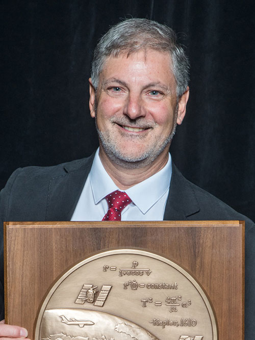
Marek K. Ziebart received the Tycho Brahe Award for outstanding innovation and leadership in the area of high-precision, physics-based radiation for modeling for spacecraft orbit dynamics. The Tycho Brahe Award is given in recognition of outstanding contributions to the science of space navigation, guidance and control.
Karl W. Shallberg received the Norman P. Hays Award for significant contributions to the FAA’s Wide Area Augmentation System, technical leadership in reference receiver development and anomaly/interference mitigation, and critical support to DOT’s Adjacent Band Compatibility study.
The Norman P. Hays Award is given in recognition of outstanding encouragement, inspiration and support contributing to the advancement of navigation.
Marco Falcone received the Thomas L. Thurlow Award for engineering contributions and leadership integral to the design of equipment used for navigation — the Galileo satnav system. The Thomas L. Thurlow Award recognizes outstanding contributions to the science of navigation.
John Raquet received the Distinguished Service Award for extraordinary service to The Institute of Navigation. The Distinguished Service Award recognizes extraordinary service to The Institute of Navigation.
The Institute of Navigation is a not-for-profit professional organization dedicated to advancing Positioning, Navigation and Timing (PNT). The Institute is a national organization with a worldwide membership.
The Institute of Navigation’s GNSS Software Defined Radio Metadata Standard working group is seeking its second and final public comment on the standard through Nov. 30.
In recent years, there has been a proliferation of software-defined radio (SDR) data-collection systems and
processing platforms designed for GNSS receiver applications or those that support GNSS bands.
For post-processing, correctly interpreting the GNSS SDR sampled datasets produced or consumed by these systems has historically been a cumbersome and error-prone process. This is because these systems necessarily produce datasets of various formats, the subtleties of which are often lost in translation when communicating between the producer and consumer of these datasets.
The GNSS SDR Metadata Standard standardizes the metadata associated with GNSS SDR sampled data files and the layout of the binary sample files.
The standard defines parameters and schema to express the contents of SDR sample data files. It is designed to promote the interoperability of GNSS SDR data-collection systems and processors. The metadata files are human readable and in XML format.
A compliant open-source C++ API for reading metadata and binary samples is also officially supported to promote ease of integration into existing SDR systems.
Comments can be made by going to sdr.ion.org and clicking on “Submit a Comment.” Public comments are being accepted through Nov. 30.
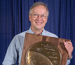
The Institute of Navigation presents Dr. Oliver Montenbruck with prestigious Johannes Kepler Award at the ION GNSS+ 2018 Conference. (Photo: ION)
The Institute of Navigation’s (ION) Satellite Division presented Oliver Montenbruck with its Johannes Kepler Award on Sept. 28 at the ION GNSS+ Conference in Miami. The Kepler Award recognizes and honors an individual for sustained and significant contributions to the development of satellite navigation. It is the highest honor bestowed by the ION’s Satellite Division.
Montenbruck was honored for his pioneering contributions to GPS for navigation of space vehicles, the advancement of multi-GNSS understanding, and tracking networks to support scientific and societal benefit.
He is head of the GNSS Technology and Navigation Group at DLR’s German Space Operations Center and an affiliated professor for GNSS at the Technical University of Munich. His research activities have been devoted to spaceborne GNSS applications, where he made contributions in the fields of receiver technology, autonomous navigation systems, spacecraft formation flying and precise orbit determination.
These range from development of the first meter-level autonomous navigation system for micro-satellites based on Kalman-filtered GPS observations, to detailed modeling of user spacecraft antenna phase-center variations, non-gravitational forces and ambiguity fixing techniques that support GNSS-based POD precision to the 1-centimeter level in support of space geodesy.
His unique expertise in the field has resulted in numerous consultancy tasks for national and European space industry and agencies. Focusing on the new satellite navigation systems, he has pioneered the advancement of monitoring networks, characterization of new navigation signals, GNSS performance assessment and multi-GNSS processing.
A GPS World Leader
In 2014, Montenbruck was honored with the GPS World Leadership Award, Products Category, for “Bringing SatNav Future into View: A Platform for Early Familiarization with New Constellations” (see his remarks here.) He also has authored several articles for the magazine, including:
He pioneered the expansion of global monitoring networks for new and modernized GNSS, initiating the Cooperative Network for GNSS Observation (CONGO), which has been a primary source of information for early assessment of Galileo, BeiDou, GPS L2C and L5 signals. His leadership and research have contributed to a thorough understanding of new GNSS constellations, enabled the full exploitation of new signals, advanced satellite technology and made multi-GNSS available to a wider community.
Montenbruck is an active member ION and past member of council. He serves on the IGS Governing Board and key working groups. Within the International GNSS Service (IGS), Montenbruck chairs the Multi-GNSS Working Group and coordinates the performance of the Multi-GNSS Project (MGEX).
Montenbruck is widely recognized for his frequently cited textbooks, ~100 publications in peer-reviewed journals, more than 250 conference papers and the Springer Handbook of Global Navigation Satellite Systems, which he co-edited and authored/co-authored. He is a recipient of the ION’s Tycho Brahe Award and the DLR Senior Scientist Award as well as the GPS World Leadership Award.
Montenbruck received his Ph.D. in 1991 and Habilitation in 2006 from the Technical University of Munich. He has supervised more than 25 master and a dozen Ph.D. theses, and served on defense committees at several international universities. As a visiting scientist, he conducted joint research projects at various international institutions, including the University of Texas at Austin, the European Space Agency, and the University of Bern.
The GPS World staff is reporting live from ION GNSS+ Sept. 24-28 in Miami, providing news, photos, videos and more. GPS World will be there with a full team, including Editor-in-Chief and Publisher Alan Cameron, Managing Editor Tracy Cozzens, Digital Editor Allison Barwacz, Editorial Director Marty Whitford and Account Manager Ryan Gerard.
The JNC, sponsored by the Military Division of the Institute of Navigation, will be held July 9-11 in a U.S. only, For Official Use Only (FOUO) environment at the Hyatt Regency Long Beach in Long Beach, California. The U.S.-only classified sessions will be held July 12 at The Aerospace Corporation.
According to ION, early registration can save $200 on conference registration fees by entering a reservation confirmation number from the Hyatt Regency Long Beach at the start of the registration process. Attendees will need a valid hotel confirmation number to claim the discount during registration.
Conference attendance for both FOUO U.S. only (July 9-11) and U.S.-only classified sessions (July 12) will be screened by the Joint Navigation Warfare Center and will be restricted to U.S. only.
Admission to the classified session will be limited to the capacity of the room and will be allocated on a first-come, first-served basis, to those who submitted visit requests in advance. Attendees requiring onsite security validation will be processed on a space-available basis. You are encouraged to submit your visit request early.
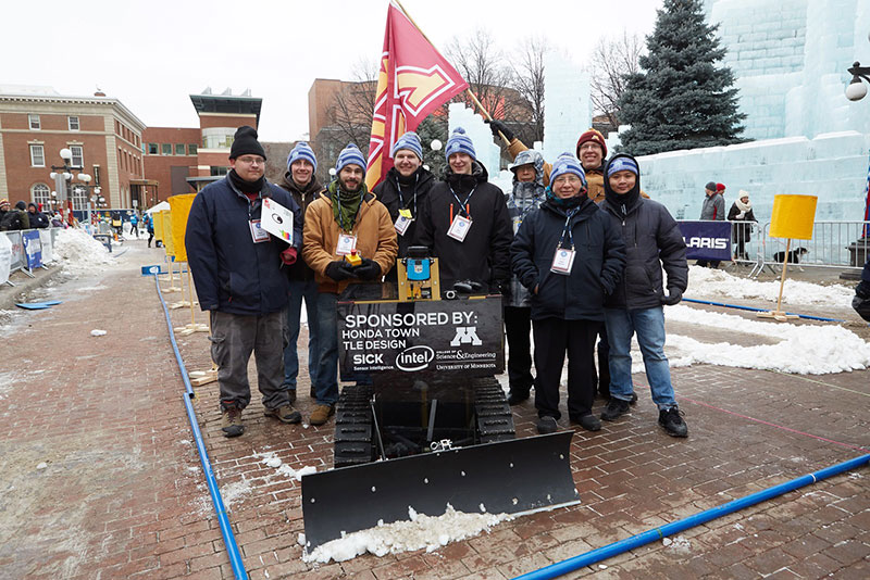
The ION Autonomous Snowplow Competition, held in cooperation with the ION North Star Section, is an international event open to college and university students, as well as the general public. According to ION, the competition challenges teams to design, build and operate a fully autonomous snowplow using state-of-the-art navigation and control technologies.
Eleven teams entered the competition, and eight of those teams successfully completed all the phases of the competition. Each team used a variety of navigation systems, including lira, optical navigation systems, inertial instruments, magnetic sensors, ultra wide-band radio reflectors, visual odometry, GNSS and differential GPS, to rapidly and accurately clear a designated path of snow.
Teams were judged based upon their cumulative scores earned throughout the competition phases, including presentations and dynamic vehicle events.
The first place team was the University of Minnesota’s “Snow Squirrel” team. The team was awarded $7,000 and a Golden Snow Globe Award, and is invited to present during the ION GNSS+ 2018 conference Sept. 24-38 in Miami. The second place team was the Dunwoody College of Technology’s “Wendigo 2018” team, which was awarded $4,000 and a Silver Snow Globe Award. Finally, the third place team was North Dakota State University’s “Thundar 3.0” team, which received $2,000 and a Bronze Snow Globe Award.
Korea will build its own navigation satellite system by 2034, providing independent positioning and navigation signals over an area spanning a 1,000-kilometer radius from the country’s capital, Seoul.
The Ministry of Science and information and communications technology (ICT) announced that it would finalize a plan for the Korean Positioning System (KPS) at a Space Committee meeting on Feb. 5.
According to a preliminary statement from the Ministry of Science and ICT, the KPS initiative will develop a ground test in 2021, core satellite navigation technology by 2022 and begin actual satellite production in 2024. The system will comprise a total of seven navigation satellites, three of them geostationary above the Korean Peninsula.
Figure from the 2016 paper shows a conceptual view of real-time WADGPS operation. The reference station transmits observation data at 1 Hz frequency to the master station. The master station is operated in real time and creates correction information and basic integrity information thereby configuring a message. A message is sent to the satellite communication simulation device according to its own transmission protocol. The satellite communication simulation device performs broadcasting of WADGPS correction information into the L1 band. A message created in every sec is coded with reserved GPS PRN C/A code and modulated with L1 frequency. Since additional correction information transmission medium such as geostationary orbit satellite or pseudolite is not considered in this study, radio frequency (RF) signals are created using simulation devices and performance was verified while connecting the signal with user receivers via cable. Additionally, a commercial communication network was used to transfer correction messages in order to verify user performance, which is located remotely. (Image: Korean Journal of Positioning, Navigation, and Timing)
Korea currently relies on the U.S. GPS system, which has suffered repeated local area jamming emanating from North Korea.
“As the GPS becomes a necessity in everyday life, broken signals for any reason can set off a nationwide chaos,” said an official for satellite navigation at the Korea Aerospace Research Institute (KARI).
Officials stated the the KPS will also improve available un-aided accuracy of GPS in its service area from about 10 meters now to less than one meter.
“Advanced nations are trying to secure strong GPS capabilities by sending up satellites to prevent a chaos that can take place while they depend on other nations’ satellites,” stated the KARI spokesperson.
The initiative appears to be separate from the Korean Wide Area Differential GPS System, whose development was the subject of a 2011 paper presented at the Institute of Navigation (ION) International Technical Meeting. The abstract for that paper stated:
“[The] project is scheduled for 2010 to 2014 under the contract with the Ministry of Land, Transport and Maritime affairs (MLTM). After that, Korea will launch a geostationary multifunctional satellite with a navigation payload which will be broadcasting augmenting signals for GPS.”
In March 2016, the Korean Journal of Positioning, Navigation, and Timing published a paper titled “Performance Analysis of WADGPS System for Improving Positioning Accuracy,” by Hyoungmin So , Jaegyu Jang, Kihoon Lee, unpyo Park and Kiwon Song. Its conclusion section stated:
“In this paper, configuration of observation reference stations and master station and initial experiment results were presented to verify accuracy correction performance of the WADGPS. The wide area correction algorithm was implemented using eight reference stations and one master station. For the initial performance verification, static and dynamic experiments were conducted. The experiment result showed that the static experiment had a horizontal accuracy performance with a level of 1 m (95 percent). In the dynamic experiment using a vehicle, performance degradation occurred compared to that of static experiment. The reason for this was due to the measured value error at the user receiver caused by multipath and visibility limitation. In summary, the implementation and performance of the algorithm of early stage were verified. For the future study, user operation characteristics will be considered and additional performance analysis on created correction information will be conducted.”
A free Cognizant Autonomous Systems for Safety Critical Applications (CASSCA) Workshop will be held 8:30 a.m.-5:30 p.m. on Jan. 29 at the Hyatt Regency Reston in Reston, Virginia. This is scheduled to take place the day before and at the same location as the Institute of Navigation’s International Technical Meeting and Precise Time & Time Interval Systems and Applications (ION ITM/PTTI) 2018 conference.
The workshop consists of a full day of presentations and discussions on the opportunities and challenges associated with developing fully autonomous systems that are cognizant and trustworthy for safety-critical applications by leading experts in the field. Speakers include:
David Corman, Program Manager, Cyber-Physical Systems Program; National Science Foundation (NSF). Dr. Corman’s current research interests are in the field of Cyber Physical Systems (CPS), security for CPS, unmanned systems, manufacturing, and technologies supporting Smart and Connected Communities.
Paul DeBitetto, Vice President, Software Engineering; Top Flight Technologies. Dr. DeBitetto leads all Top Flight’s Software and Embedded Systems Development. That includes product-related flight control, simulation, computing, sensing, data communications, security-related controls and software solutions.
Finch Fulton, Deputy Assistant Secretary for Transportation Policy; Department of Transportation (DOT)
Joao Hespanha, Professor and Chair of Department of Electrical and Computer Engineering; University of California, Santa Barbara. His current research interests include hybrid and switched systems; multi-agent control systems; distributed control over communication networks (also known as networked control systems); the use of vision in feedback control; stochastic modeling in biology; and network security.
Robert Peterson, Professor and Director of Center for Insurance Law and Regulation; Santa Clara University.
Mr. Peterson teaches torts, insurance law and regulation, evidence and products liability, and other courses. He is a past chair of the California State Bar Standing Committee on Insurance Law, and is director of the Law School’s Center for Insurance Law and Regulation.
Signe Redfield, Roboticist and Mission Manager; Naval Research Laboratory (NRL). Dr. Redfield’s primary interests include performance evaluation of autonomous systems, foundations of robotics, and cooperative behaviors for autonomous underwater vehicles.
Giorgio Rizzoni, Professor and Director of Center for Automotive Research (CAR); The Ohio State University. The CAR is an interdisciplinary university research center that conducts research on advanced automotive and transportation technologies and systems engineering, focusing on sustainable mobility, advanced propulsion systems, human safety and the environment.
Steven Rogers, Senior Scientist for Automatic Target Recognition and Sensor Fusion; Air Force Research Laboratory (AFRL). Dr. Rogers serves as the principal scientific authority and independent researcher in the field of multi-sensor automatic target recognition and sensor fusion.
Registration is also now open for the ION International Technical Meeting (ITM) and Precise Time and Time Interval Systems Applications Meeting (PTTI), which begin the next day (January 30-February 1) at the same location. See www.ion.org/itm for more information.
Shortly after GPS World’s 2017 Leadership Awards ceremony during ION GNSS+ week, the Institute of Navigation rolled out its own distinguished panel of award recipients at a conference luncheon.
ION’s Satellite Division presented Terry Moore with the Johannes Kepler Award, its highest honor. It is perhaps a bit of editorial license to call Terry Moore “one of our own,” but he has been an advisor to the magazine for lo, these 17 years or more. During that time his technical papers have formed the basis for several feature articles, and he has guided many of his students and colleagues to authorship in these pages.
Director of the Nottingham Geospatial Institute (NGI) at the University of Nottingham, where he has long served as professor and dean, he is also a consultant and advisor to European and UK government organizations and industry. He did extensive work on the introduction and implementation of WGS 84 as the standard reference system for air and marine navigation, developed software tools for coordinate transformations and map projections, and pioneered the use of raw GPS code- and carrier-phase data from low-cost receivers.
He is the founding director of the GNSS Research and Applications Centre of Excellence, which targets knowledge transfer between the NGI and business. He has a long career of volunteer service for both ION and the Royal Institute of Navigation. In this as in other things he exemplifies the best of the scientific community, or of any community for that matter.
Among his articles for the magazine are “Not Just a Fairy Tale: A Hansel and Gretel Approach to Cooperative Vehicle Positioning,” 2014; “Network RTK for Intelligent Vehicles,” 2013; “Aiding Indoor Pedestrian Navigation with Building Heading,” 2011; “Integrating Computer Vision and Inertial Navigation for Pedestrian Navigation,” 2011; “Assessing Network RTK Wireless Delivery,” 2009; “Ubiquitous Positioning: Anyone, Anything: Anytime, Anywhere,” 2007; and “Simulation GPS in Urban Traffic Environments,” 2005.
I was privileged to serve as in-house editor for many if not all of these articles. A learning experience that could have been more so had I applied myself harder. Story of my life.
Nowhere to be found in the curriculum vitae of this Ph.D. in space geodesy are his performance as Commander Bond in “GNSS Murder, Mystery and Mayhem at the Mansion,” where he drank a mean martini, shaken not stirred, nor his regular appearances as vocalist at the NavtechGPS Open Mic Night, most recently dueting on “Paradise by the Dashboard Lights.”
All of us at the magazine join in congratulating Terry on this well-deserved honor!
Organized by Professor Zak Kassas from the University of California, Riverside, the workshop will feature presentations and panels by experts and leaders from government (National Science Foundation, Office of Naval Research, Air Force Research Laboratory, Department of Transportation), industry (Google, Daimler, and Ford) and academia (The Ohio State University, UC San Diego, University of Southern California).
The workshop will discuss opportunities and challenges (technical, commercial, ethical, and legal) associated with developing fully autonomous systems that are cognizant and trustworthy for safety-critical applications. Examples include unmanned aerial vehicles (UAVs), self-driving cars and unmanned underwater and surface vehicles.
Kassas, director of the Autonomous Systems Perception, Intelligence, & Navigation Laboratory (ASPIN), leads a team of researchers developing reliable and accurate navigation that exploits existing signals of opportunity, rather than GPS, to meet the stringent requirements of fully-autonomous systems, such as UAVs and self-driving cars.
The Institute of Navigation’s (ION) Satellite Division presented Professor Terry Moore with its Johannes Kepler Award for his outstanding contributions to the development of satellite navigation through a sustained and distinguished professional career devoted to research and teaching.
Moore received the award Sept. 29 at the ION GNSS+ Conference in Portland, Ore. Moore is a member of the GPS World Editorial Advisory Board.
Terry Moore has more than 30 years of research experience in surveying, positioning and navigation technologies, and is a consultant and advisor to European and U.K. government organizations and industry.
He has taken a leading role in national and European initiatives aimed at integrating academic research and teaching activities in GNSS and interacting closely with industry.
Moore is credited with extensive work on the introduction and implementation of WGS 84 as the standard reference systems for air and marine navigation, as well as the development of standard software tools for coordinate transformations and map projections used extensively through the aviation industry.
Additionally, he is known for the development of GRINGO software that pioneered the use of raw GPS code and carrier phase data from low cost Garmin receivers. His work has also includes the pioneering of novel methods and algorithms for GPS orbit relaxation; which led to reduced dynamic GPS-based orbit determination for LEO spacecraft, with a real-time implementation.
Moore is the Director of the Nottingham Geospatial Institute (NGI) at the University of Nottingham where he has responsibility for all of NGI’s research and teaching. He is also the founding Director of GRACE, the GNSS Research and Applications Centre of Excellence, which was jointly funded by the University of Nottingham and East Midlands Development Agency, and targets knowledge transfer between the NGI and business. Additionally, he leads the university-wide Aerospace and Transport Technology Research Priority Area.
Moore has supervised numerous research projects funded by industry, research councils, the European Space Agency and the European Commission, and has supervised more than 30 Ph.D. students.
Moore is involved in the volunteer activities of numerous international professional and scientific bodies. He is currently a Royal Institute of Navigation (RIN) Vice-President (now also President Elect) and a member of their Technical Committee, while simultaneously serving on the ION Council as a Technical Representative and as a co-chair of the ION’s Satellite Division’s Technical Peer Review Committee.
He has served on the ION’s Satellite Division Executive Committee on numerous occasions and is a past ION GNSS+ program and general chair.
Moore is a Fellow of both the Institute of Navigation and the Royal Institute of Navigation (RIN). He is also a Fellow of the Chartered Institution of Civil Engineering Surveyors, a Fellow of the Royal Astronomical Society and an Associate Fellow of the Remote Sensing and Photogrammetry Society. In 1999 and 2008 he was awarded the RIN Richey Medal (best paper in the RIN Journal of Navigation), in 2013 was awarded the RIN Harold Spencer-Jones Gold Medal (outstanding contributions to navigation), and in 2016 the RIN J.E.D. Williams Medal (contributions to the RIN).
He holds a BSc degree in Civil Engineering and Ph.D. degree in Space Geodesy, both from the University of Nottingham, where he was promoted to the U.K.’s first Chair of Satellite Navigation in 2001.
The Johannes Kepler Award recognizes and honors an individual for sustained and significant contributions to the development of satellite navigation. It is the highest honor bestowed by the ION’s Satellite Division.