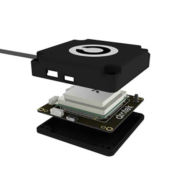
GNSS corrections company Rx Networks is collaborating with Zephr.xyz, whose software-based positioning SDK enables sub-meter accuracy on Android devices without requiring specialized hardware.
Through this collaboration, Zephr.xyz has integrated Rx Networks’ TruePoint correction services, extending high-precision GNSS capability worldwide with the reliability, availability and continuity required for commercial-scale deployment.
Operating on a global scale, Rx Networks is a provider of GNSS positioning services for tier-1 OEMs, telecom operators, and enterprise customers. Its services are engineered to ensure a five-nines (99.999%) service level agreement for availability, supporting mission-critical and safety-critical applications where continuity, resilience and predictable performance are essential.
Unlike free, experimental or regionally constrained solutions, Rx Networks’ infrastructure is designed for global availability and long-term operational reliability, making it suitable for large-scale commercial deployments.
TruePoint is Rx Networks’ comprehensive high-precision positioning portfolio, designed to support a broad spectrum of customer requirements. Rather than a one-size-fits-all product, TruePoint has solutions that span
global, regional and localized GNSS correction services
accuracy tiers from decimeter-level to centimeter-level performance
multiple deployment models and price-performance options.
TruePoint is designed to evolve alongside customer needs, supporting everything from early-stage experimentation to large-scale production deployments. While Zephr.xyz leverages TruePoint | FOCUS, the collaboration is not limited to a single TruePoint variant, preserving flexibility as applications mature.
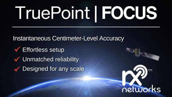
Rx Networks has introduced TruePoint | FOCUS, a high-precision, cloud-based GNSS correction service that offers instantaneous centimeter-level accuracy for a variety of applications. This service is designed to address the needs of industries requiring real-time precision, such as micro-mobility, smart agriculture, robotics, UAVs, IoT and machine control.
TruePoint | FOCUS supports both Real-Time Kinematic (RTK) and PPP-RTK modes to offer flexibility and high performance. The RTK mode is hardware-agnostic, ensuring compatibility with any RTK-enabled GNSS receiver. It uses standard correction protocols like RTCM v3 and supports access via NTRIP for seamless integration and rapid deployment. The PPP-RTK mode leverages State Space Representation (SSR) to deliver high-accuracy positioning with optimized bandwidth usage. This mode combines the benefits of global coverage from PPP with the fast convergence times of RTK, making it suitable for applications requiring seamless operation over large areas.
The service is notable for its ability to process more GNSS signals than many competing solutions, enhancing its resilience and performance in challenging environments. It supports signals from GPS, Galileo and BeiDou constellations, offering comprehensive correction capabilities. According to the company, TruePoint | FOCUS guarantees consistent centimeter-level accuracy with a 99.9% service level agreement, ensuring reliability for users operating in regions such as North America, Europe and China.
TruePoint | FOCUS is available for trial in both RTK and PPP-RTK modes across covered regions, with plans to expand its geographic reach. Interested users can request a complimentary 30-day trial license to evaluate the service.
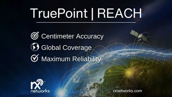
Rx Network has launched TruePoint | REACH, an advanced, hardware-agnostic, cloud-based correction service designed to deliver centimeter-level location accuracy worldwide for various professional applications.
TruePoint | REACH offers precise centimeter-level positioning to enhance GNSS receivers’ performance in applications such as precision agriculture, machine control, mining, marine operations, UAV, GIS and more. The service is compatible with leading commercial off-the-shelf receivers using the RTCM 3.3 SSR and the 3GPP LPP SSR format. The company said key hardware partnerships are in the planning stages and will be announced soon.
TruePoint | REACH eliminates the need for users to set up their own base stations. Users can achieve centimeter-level accuracy by connecting receivers to the cloud while leveraging Rx Networks’ comprehensive global coverage.
Its correction engine is built to provide centimeter-level accuracy worldwide and can achieve sub-3cm precision in under 10 minutes. This makes it suitable for applications that require moderate initialization times for high-precision services.
A test version of TruePoint | REACH is available for those interested in assessing its capabilities. Users can sign up for a complimentary 30-day trial license through the Rx Networks website.
Rx Networks, a GNSS data services provider, has released TruePoint | LITE, a correction service designed for power-conscious applications that require precise and reliable location data.
TruePoint | LITEaims to deliver sub-meter and lane-level accuracy with global coverage for low-power usage. It is engineered with power efficiency in mind, focusing on applications such as smartphones, wearables, asset tracking and Internet of Things (IoT) devices.
TruePoint | LITE uses patent-pending predictive technologies designed to reduce dominant GNSS ranging errors—including ionospheric, orbital, and clock errors—to ensure accurate GNSS positioning while minimizing data traffic and conserving battery life.
TruePoint | LITE leverages proprietary predictive technologies to correct key GNSS ranging errors, particularly ionospheric range errors, according to the company.
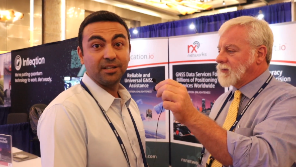
GPS World Editor-in-Chief, Matteo Lucio, stopped by the RX Networks booth to talk about company updates and new products with Ali Soliman, head of sales and marketing, RX Networks.
Rx Networks, Inc., a GNSS data services company, announced the availability of TruePoint.io precise location services on Qualcomm’s Snapdragon 8 Gen 1 and Snapdragon 888 5G Mobile Platforms. TruePoint.io integration empowers Android smartphones to achieve enhanced location accuracy down to a meter or less – something previously only seen with high-grade receivers.
With enhanced location accuracy, superior user experience for such use cases as rideshare, micro-mobility, health and fitness and lane-level requirement applications can now be realized. The enablement of reliable meter-level location accuracy on mobile phones will unlock the potential of location-based services and open the door for other innovative and unique use cases. The limitations of a standalone GNSS chipset no longer become the barrier to pursuing the vision of connected ecosystems reliant on location.
TruePoint.io enables scalable, reliable, and affordable ways to leverage high-precision location on smartphones powered by Snapdragon mobile platforms. Rx Networks’ global coverage, including China, gives smartphone OEMs the advantage of a single GNSS corrections vendor that works across all continents.
“Rx Networks provision of GNSS data services for accurately positioning smartphones using Snapdragon mobile platforms will enable meter-level location accuracy almost everywhere smartphones can connect to a terrestrial cellular network,” said Francesco Grilli, Vice President, Product Management at Qualcomm Technologies, Inc. “Meter-level location accuracy is poised to improve smartphone user experiences and spur the creation of exciting and innovative services for businesses and consumers.”
TruePoint.io is scheduled to be available on Snapdragon mobile platforms initially in China in Q4 2022 and globally in H1 2023.
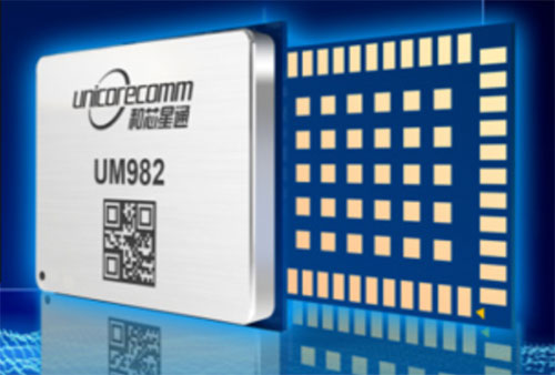
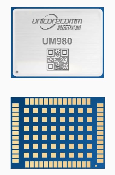
Rx Networks is offering for both the North and South American markets the next-generation high-precision GNSS modules from Unicore Communications, based in China.
Based on the new NebulasIV systems-on-chip (SOC), the UM960, UM980 and UM982 modules offer all-constellation, multi-frequency, high-precision real-time kinematic (RTK) positioning and heading capabilities.
Rx Networks is exhibiting at ION-GNSS+ taking place this week in Denver, at Booth 108, and will exhibit at Intergeo in Essen, Germany, Oct. 18-20, at Booth F2.033.
Available in a small footprint with low-power consumption, the Unicore modules are suited for use in reference stations, surveying and mapping, precision agriculture, heading applications, machine control, drones and robotics, vehicle navigation, precision timing, and more.
Photo: Unicore
Rx Networks is a key supplier of high-accuracy services and assistance data to a growing list of GNSS hardware manufacturers. As high-precision GNSS becomes ubiquitous, those seeking precise positioning solutions can now have Unicore GNSS hardware enlightened with Rx Networks data services.
“We are pleased to be bringing this new leading GNSS Technology into the Americas,” said Cameron Baird, head of Business Development, GNSS Hardware. “With further product miniaturization coupled with added performance, features and functionality, Unicore GNSS technology is well suited for all precision GNSS applications.”
Unicore is a manufacturer of GNSS hardware and a sister-company to Rx Networks within the BDStar group of companies, which is headquartered in Beijing, China.
Unicore GNSS receivers have been deployed in a wide variety of applications, including reference stations, surveying, mapping, precision agriculture, machine control, drones and robotics, vehicle navigation, timing, internet of things (IoT) and more.
Rx Networks is a supplier of high-accuracy services and assistance data to a growing list of GNSS hardware manufacturers. As high-precision GNSS becomes ubiquitous, those seeking precise positioning solutions can now make use of Unicore GNSS hardware made even more accurate with Rx Networks data services.
“Unicore GNSS hardware has shown to have outstanding positioning performance,” said Cameron Baird, head of Business Development, Hardware Sales. “I am excited to see the democratization of inexpensive high-precision GNSS hardware with Rx Networks’ TruePoint.io PPP-RTK correction services.”
Rx Networks has added a new extended ephemeris service called StarCourse.
According to the company, real-time ephemeris services provide GNSS chipsets in connected mobile devices a headstart in determining position accurately and quickly. For devices with limited connectivity, typical extended ephemeris solutions have provided a headstart with 7-14 days of ephemeris data.
With the evolution of the internet of things (IoT), low power consumption and a limiting of connection time are essential for extending the usable life of a device. This creates a challenge for IoT vendors seeking an extended ephemeris offering that can minimize onboard resource usage without compromising accuracy.
The new StarCourse service provides a 50% reduction in RAM requirements, 90% reduction in CPU cycles, and ephemeris accuracy exceeding that of previous market offerings. This empowers Rx Networks customers to extend the usable life of their products while delivering an excellent positioning experience, the company said. Full data customization is offered to StarCourse subscribers, allowing them to create optimal solutions for their needs.
StarCourse enables autonomous positioning on a wide array of connected GNSS IoT devices, including asset tracking, wearables, in-dash navigation and mobile devices. For situations where accuracy is paramount, StarCourse Premium provides ultra-precise predicted ephemeris for the first 24 hours.
“GNSS assistance services are essential to solving the spatial intelligence requirements of the booming IoT world,” said Chris Perriam, product owner at Rx Networks. “StarCourse endeavours to quickly enlighten all connected devices with location.”
Rx Networks provides location information to strengthen the connection between people, devices and businesses by improving the GNSS experience and creating enhanced opportunities for next-generation products and services.
GPS had been around for about five years before first launch in February 1978 and Full Operational Capability (FOC) was eventually declared in April 1995. It takes time to develop, field and prove something as complex as the world’s first satellite navigation system. But we’re now well into a third generation of the venerable GPS, with GLONASS, Galileo, BeiDou and IRNSS/NavIC and QZSS around the world and in geographic locales. So, putting aside Transit or anything else, this would make GPS about 47 years old — heading into middle age.
Therefore, it would seem that Glen Gibbons waited until “this GPS thingy” looked like it might actually work — circa 1990 — to launch GPS World, since the magazine is now 30 years old and is also into its third-generation of editor-custodians! Alan Cameron bravely carried the flag after Glen and nurtured the magazine for a good number of years and brought me into the fold as a contributor. We shared ION GNSS conventions and GPS World Leadership dinners and he was able to cajole monthly articles out of me for many years. Now Marty Whitford has his hand firmly on the tiller as publisher, with Tracy Cozzens as senior editor.
So what went down during these decades of technological advancement and for many of the people in the satnav industry? It would be impossible to answer within my word-limit, so I’ll take on an extremely small subset and recount a few things I can still remember.
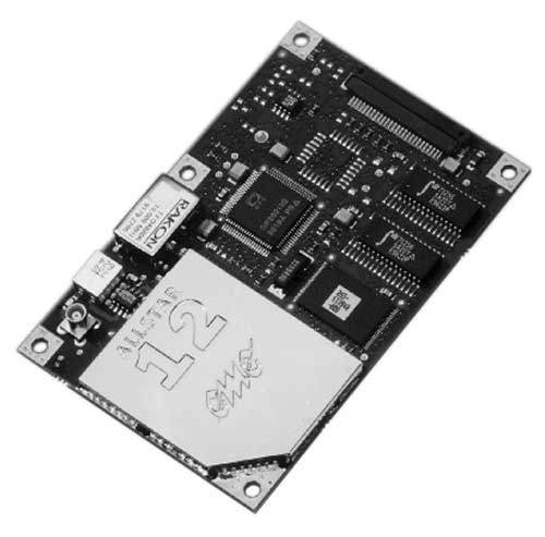
µGPS. I got into GPS around 1990 in an OEM board-level product spin-off program from a certified GPS airborne receiver at CMC in Montreal — we initally called that L1 receiver µGPS because then it was a small GPS board. Later it became known as the AllStar receiver. We found pretty neat applications for the early ’90s — golf-course systems, vehicle tracking, airport vehicle tracking, the start of vehicle nav systems and such.
At NovAtel in Calgary in the early ’90s, we watched things develop through L1/L2 dual frequency, began RTK market applications in survey, geographic information systems (GIS), agriculture, mining and all multitudes of attempts to get new companies off the ground.
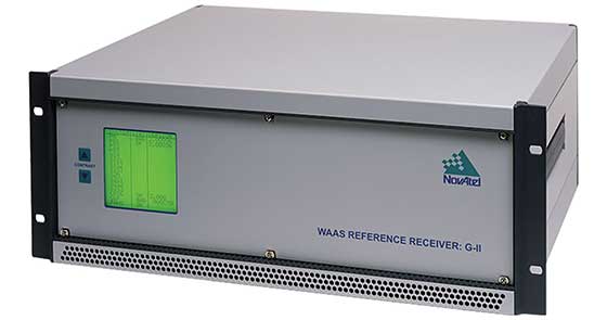
WAAS. Eventually the U.S. Wide-Area Augmentation System (WAAS) program came and swallowed us up through three different prime contractors. Once that Federal Aviation Administration program was running well, we were into programs in Europe, Japan, India and China, and that led into Galileo ground reference receivers. The software qualification work we did on Galileo positioned us to take on mil-spec receiver work, and even anti-jam products.
Then CMC bought NovAtel, and we also joined with CMC to develop a certified airborne receiver. In 2003, NovAtel bought the AllStar OEM product line from CMC — funny how things work out! The joint certified receiver program eventually resulted in a new generation of high-accuracy airborne sensors. We again changed hands in 2007 when Hexagon bought us, and then NovAtel began working closely with Hexagon subsidiary Leica on survey applications. Many new and interesting developments are still going on there.
Nowadays, my interests lie with assisted GNSS and with Rx Networks in Vancouver, which I support and advise. Assisted GNSS comes in many forms, has many avenues in the marketplace, and presents its own unique challenges.
As GPS has evolved into GNSS and into so many, many applications, companies have come and gone but the core of people who drive the industry has grown and acquired new and specialized skills, developing ever more capable technology and products. Even after 47 years of the industry and 30 years of GPS World, we aren’t anywhere close to done.
A roundup of recent products in the GNSS and inertial positioning industry from the November 2019 issue of GPS World magazine.
SURVEYING & MAPPING
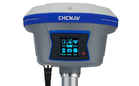
IMU-RTK receiver
Increases GNSS availability and reliability
Photo: CHC Navigation
The i90 IMU-RTK GNSS series receiver is designed to dramatically increase GNSS real-time kinematic (RTK) availability and reliability. The i90 is powered by the company’s latest inertial measurement unit (IMU) and RTK technology to provide robust and accurate GNSS positioning in any circumstances. Unlike standard micro-electro-mechanical (MEMS)-based GNSS receivers, the i90 GNSS IMU-RTK combines a high-end calibration and interference-free IMU sensor with a state-of-the-art GNSS RTK engine and advanced GNSS tracking capabilities. The i90 is designed to increase the productivity and reliability of survey projects, with no complicated calibration process, rotation, leveling or accessories are necessary. A few meters’ walk will initialize the i90 internal IMU sensor and enable RTK survey in difficult field environments. The i90 GNSS automatic pole-tilt compensation boosts survey and stakeout speed by up to 20%.
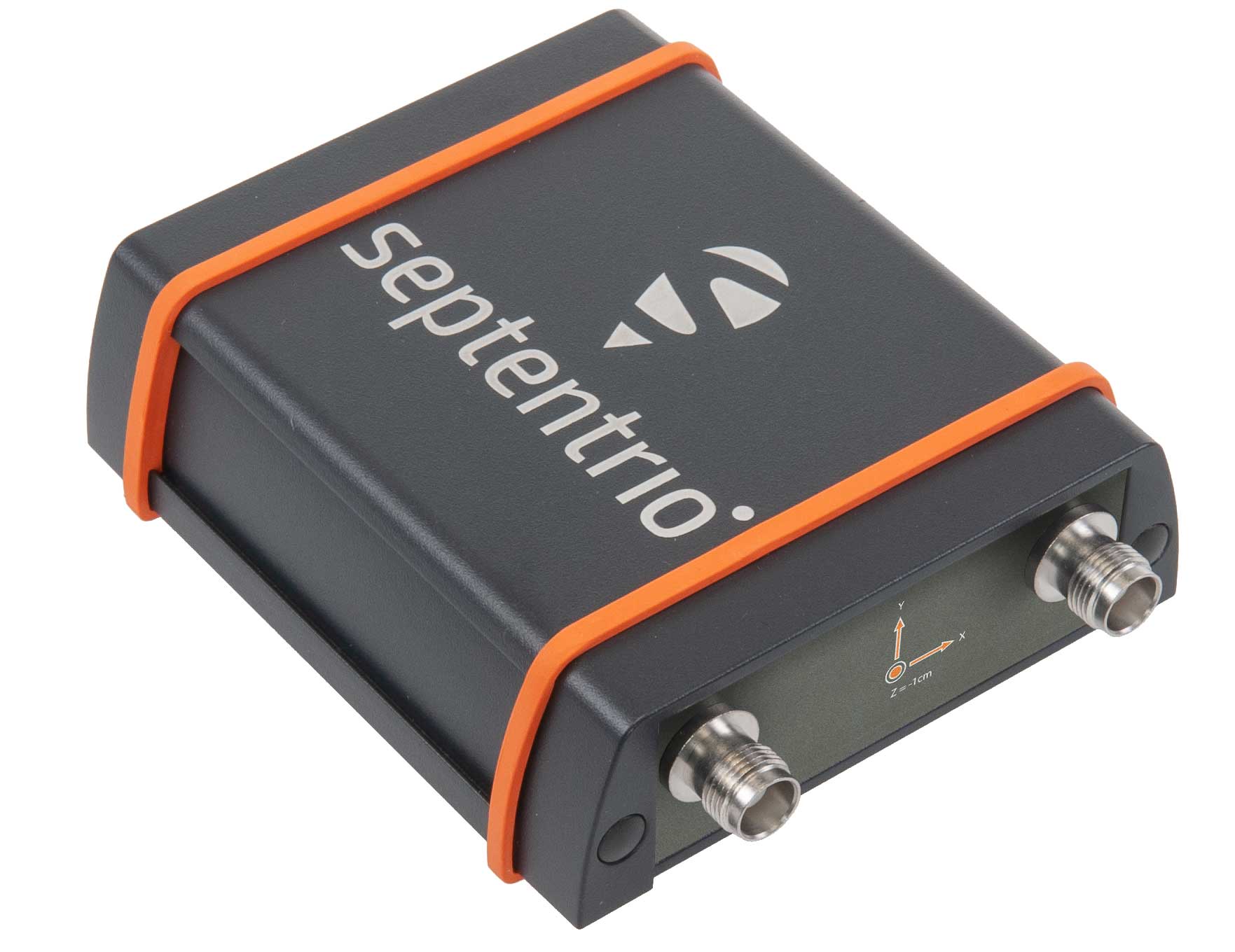
Both accurate and rugged for machine control, logistics
The AsteRX-SBi has a rugged housing, making it suitable for machine control and other outdoor uses. (Photo: Septentrio)
Septentrio has expanded its GNSS/INS portfolio with the AsteRx SBi, a new housed GNSS/INS receiver. The ruggedized AsteRx SBi fuses high-accuracy GPS/GNSS with a high-performance inertial sensor to provide reliable positioning and 3D orientation for machine control and logistic applications. Within its rugged, waterproof enclosure, a high-performance GPS/GNSS is coupled with an industrial-grade inertial sensor to provide high-accuracy, reliable positioning and 3D orientation (heading, pitch, roll). Offering the flexibility of either single or dual antenna, the AsteRx SBi is designed for quick and easy integration into any machine monitoring or control system. Reliable location and 3D orientation data is streamed with a high update rate and constant low latency. Septentrio’s reliable centimeter-level positioning is based on true multi-frequency, multi-constellation GNSS (GPS, GLONASS, Galileo, BeiDou, QZSS) technology.
The Trimble X7 laser scanning system is designed for surveying, construction, industrial and forensic applications. It enables professionals to quickly and easily capture precise 3D scanning data to produce high-quality deliverables. The X7 features Trimble X-Drive technology, survey-grade self-leveling and a smart calibration system. It integrates streamlined workflows to provide automatic registration of point-cloud data in the field with Trimble Registration Assist, bringing scans together through self-leveling inertial measurement unit technologies and cloud-based software.
The Bluesky MetroVista range includes high-resolution imagery combined with high-accuracy, wide-scale 3D models. (Image: Bluesky)
The MetroVista city mapping service for Europe incorporates the Leica CityMapper hybrid airborne sensor designed for 3D city modeling and urban mapping. The sensor includes a vertical camera and survey-grade oblique cameras, and incorporates lidar to accurately collect elevation and infrared data. The MetroVista range includes high-resolution imagery combined with high-accuracy, wide-scale 3D models. CityMapper has already been used to capture MetroVista data for cities across the United Kingdom, including London, Manchester, Newcastle and Bristol.
The enhanced GSS9000 series GNSS constellation simulator has been updated to provide significantly improved capability, flexibility and performance to meet the test needs of high-performance navigation systems. It doubles the number of supported channels (320 in a single chassis) while maintaining its full performance specification in key areas such as signal iteration rate and low latency under maximum signal dynamics. These attributes, together with the ability to produce a comprehensive range of emulated multi-GNSS, multi-frequency RF signals, enables full and future-proofed testing of advanced applications. Greater signal flexibility is also built into the enhanced GSS9000 through its open application program interface (API) and flexible architecture. This delivers a highly sophisticated arbitrary waveform generator (AWG) capability.
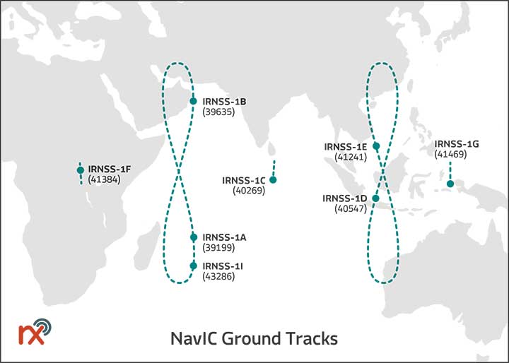
Rx Networks has added NavIC constellation support to its real-time and predicted-assistance data service. The company’s technology partners — semiconductor vendors, mass-market mobile device manufacturers and network operators — now have global support for all satellite navigation systems and L1 satellite-based augmentation systems (SBAS) for any region around the world. Used daily by more than two billion devices, Rx Networks data is delivered via ephemeris in RINEX and via the Location.io interface, with predictions in SP3. Predictions for NavIC via the Location.io platform will be added in the first quarter of 2020.
Endura micro-electro-mechanical system (MEMS) timing solutions are designed for aerospace and defense applications including precision GNSS. They provide high performance in harsh conditions such as severe shock, vibration and extreme temperature. SiTime offers customers 5 million possible part numbers that can be created from 17 programmable products. Solutions accommodate 4 parts per trillion per g force of acceleration (50 times better than quartz); support for –55° C and +125° C operation; timing specifications conforming to MIL-PRF-55310; and Endura Super-TCXOs (temperature compensated oscillators) for use in GNSS applications.
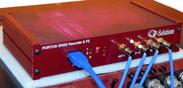
Portos Team paired with the Ninja. (Photo: IP-Solutions)
Portos Team is a new GNSS RF signal record-and-playback system. It can record and play back — or simulate —multi-frequency, multi-system GNSS signals when paired with the company’s Replicator. It can do the same for CRPA signals when paired with the company’s Ninja. The Portos itself can also operate as multi-frequency or CRPA front end for a GNSS software receiver.
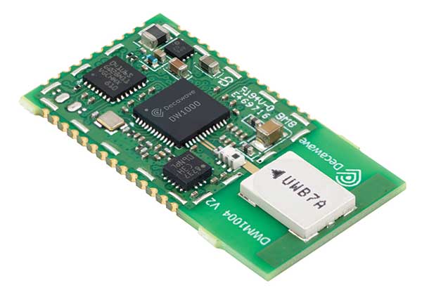
The DWM1004 module targets time difference of arrival (TDoA) tag applications that require years of battery life and a compact design. Based on the DW1000 chipset, the DWM1004C offers high-accuracy, real-time-location capability with a 6.8-Mbps data rate. It delivers more than five years of battery life. Real-time location systems (RTLS) enable managers to have a real-time view of their operations through data collected from connected objects such as tools, pallets, forklifts, badges and collars. The DW1000 is immune to multipath fading, with 2-centimeter precision in indoor environments.
The F9P Sirius RTK GNSS rover is designed to be mounted on a moving vehicle. The u-blox ZED-F9P module inside provides 1-cm position accuracy, a convergence time under 10 seconds and a navigation update rate up to 20 Hz. The rover has a built-in active antenna patch. It receives GPS, Galileo, Beidou and GLONASS signals, providing additional accuracy. It is designed to fit most setup designs as well as integrate easily into a vehicle. Its six-pin JST-GH connector makes it plug-and-play with the Pixhawk Pro 3 autopilot.
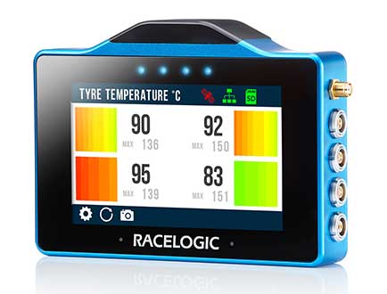
The VBOX Touch is a highly flexible GNSS datalogger with enhanced accuracy. The powerful hardware can be used diverse automotive tests such as acceleration, braking, speed verification, tire temperature monitoring, lap-timing and durability. The VBOX Touch comes preloaded with a sophisticated performance application that covers common use cases; applications can be downloaded from an online library. Racelogic can also write custom Python scripts based on customer requirements.
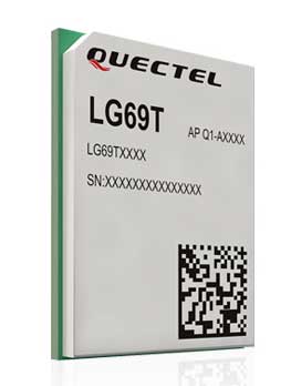
The LG69T GNSS module is an automotive-grade dual-band high-precision GNSS module that integrates dead-reckoning (DR) and real-time kinematic (RTK) technologies. The module facilitates open-sky positioning performance with an accuracy of up to 10 centimeters. It supports next-generation precision positioning capabilities for smart vehicles and autonomous driving scenarios. The LG69T module is based on ST’s STA8100GA, the latest automotive-grade dual-frequency positioning chip with 80 tracking channels and four rapid-acquisition channels compatible with GPS, BeiDou, Galileo, Navic and QZSS. The AEC-Q100-qualified dual-band module integrates multi-band RTK technology for centimeter-level accuracy. The LG69T module’s dead-reckoning capabilities feature an integrated inertial measurement unit (IMU) that provides continuous high-precision positioning.
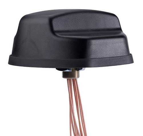
The Coach II antenna with GNSS L1/L2/L5 is designed to provide greater precision and reliability for advanced rail communications systems, enabling next-generation positive train control (PTC) and passenger Wi-Fi. The Coach II features global multi-GNSS compatibility, dual-port 4G LTE / sub-6 GHz 5G NR and 802.11ac Wi-Fi / Bluetooth connectivity. It is AAR compliant for railway applications and is IP67-rated.
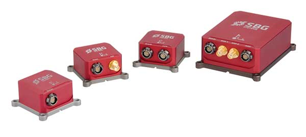
Includes new automotive package for Ellipse GNSS/IMU products
Photo: SBG Systems
New features have been added to the Ellipse product line with firmware update version 1.7. The update better answers needs of the autonomous testing and driving markets such as a CAN odometer. Users now have the choice to connect an external odometer (DMI) with pulses or use their car odometer with velocity information. New outputs include body velocity and slip angle, which calculate the drift angle between the vehicle’s assumed trajectory and its actual trajectory. For precision applications as well as low dynamics and reduced warm-up time, the new firmware allows users to run the Ellipse Kalman filter with no lever-arm estimation. This will ensure centimeter pass-to-pass accuracy for real-time kinematic (RTK) applications and allow operation in lower dynamics while reducing warm-up time. The firmware update also provides new features for advanced marine applications.
Rx Networks Inc., a mobile location technology and services company, has announced support for the NavIC Constellation.
The company made the announcement at ION GNSS+, held earlier this month in Miami, Florida.
Rx Networks’ comprehensive GNSS constellation data service provides technology partners — and their associated customers — real-time and predicted assistance for all satellite navigation systems and L1 satellite-based augmentation systems (SBAS) for any region around the globe.
The addition of NavIC builds on Rx Networks’ brand promise (to deliver “location enlightened” products and services) by providing real-time and predicted GNSS assistance data in any individual or combination of formats. This enables developers to optimize device performance for specific use cases and conform to national requirements.
Data is delivered via ephemeris in RINEX and Predictions in SP3, P-GNSS and RT-GNSS, via the Location.io platform, will be added in the first quarter of 2020.
“Our Location. Enlightened. brand promise speaks to our goal of providing the most comprehensive, relevant, accurate and reliable location data available,” said John Carley, vice president of sales and marketing at Rx Networks. “The addition of NavIC in our carrier-grade infrastructure demonstrates our commitment to our brand and to stay on the leading edge of truly global satellite-based positioning and services. The ability to offer NavIC support is extremely significant as it ensures we can support our customers with exactly what is required in any given region of the Globe.”
NavIC, formerly known as IRNSS (Indian Regional Navigation Satellite System), combines GEO and IGSO satellites to provide a regional position, navigation and time (PNT) system including ionospheric corrections.