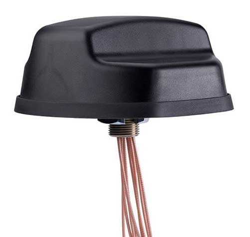
PCTEL Inc. has released an antenna that combines precision multi-constellation GNSS with high-performance LTE, sub-6 GHz 5G, Bluetooth and Wi-Fi connectivity.
The Coach II antenna with GNSS L1/L2/L5 is designed to provide greater precision and reliability for advanced rail communications systems, enabling everything from next-generation positive train control (PTC) to passenger Wi-Fi.
“Precise timing and tracking information is critical not just for rail, but for a variety of fleet, public safety, and industrial IoT [internet of things] applications,” said Rishi Bharadwaj, PCTEL’s chief operating officer. “PCTEL’s antenna technology enables our customers to deploy new technologies with confidence,” added Bharadwaj.
PCTEL is displaying its Coach II antenna with GNSS L1/L2/L5 on Sept. 22-24 at RSSI C&S Exhibition in Minneapolis, Minn. It is available to order now for shipment in early November using part #GL125-DLTEMIMO.
The Open Geospatial Consortium (OGC) is inviting members and non-members to participate in its 3D IoT Platform for Smart Cities Pilot.
The goal of the pilot, which is sponsored by the Korea Land and Housing Corporation, is to advance the use of open standards for integrating environmental, building and internet of things (IoT) data in smart cities. It will focus on two scenarios: real-time monitoring of indoor occupancy and real-time monitoring of micro-dust air pollutants.
According to OGC, participants in this pilot will connect their technology and expertise with real city needs while collaborating with other participants to advance open standards for smart cities. OGC hopes the outcomes of the pilot will help facilitate and standardize the access to environmental, building and IoT data in smart cities.
This Initiative is being conducted under OGC’s Innovation Program, the research and development laboratory of OGC. Under OGC’s Innovation Program, sponsors and OGC members come together to address geospatial IT challenges.
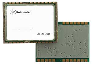
JEDI-200 reduces the energy of getting one position fix by up to 150 times, according to the company.
Photo: Kolmostar
Kolmostar, a positioning technology company, has launched an ultra-low-power GNSS module at IoT World, which took place May 13-16 in Santa Clara, California.
JEDI-200 reduces the energy for one position fix by up to 150x compared to traditional GNSS sensors, providing a positioning solution for location-based internet-of-things applications, the company said.
1-second ultra-fast time to first fix from cold start
2-meter CEP high positioning accuracy
Supports GPS and Beidou constellations
100-byte compressed ephemeris (EPH) to enable A-GPS with speedy download via LPWAN technologies such as LoRaWAN and NBIoT
High-performance cloud computing based on 50-byte raw position files for optimized radio transmission efficiency and minimum endpoint power consumption
Integrated SAW filter, stand-alone LNA and TCXO
12 x 16 millimeter form factor for easy RF integration
“JEDI-200 supports GPS as well as Beidou constellations,” said Tao Tong, co-founder and CEO of Kolmostar. “While achieving industry’s lowest power consumption, it helps our customers to achieve high accuracy even in dense urban canyon environment where existing GNSS modules on the market often drift due to multipath and other errors.”
The JEDI-200 is designed specifically for IoT applications such as human and asset trackers (for bikes, scooters, vehicles, cargo, livestock, pets and more), smart wearables, smart farming and infrastructures,.
Its reduced level of power consumption and its optimized efficiency with LPWAN technologies solve IoT endpoint deployment’s pain-point of needing frequent recharges or a large battery, enabling new possibilities in location-based IoT applications.
Bluetooth has added a new direction-finding feature to help meet the growing demands of the location services market.
The feature, which allows devices to determine the direction of a Bluetooth signal, was added to Bluetooth in version 5.1 of the Bluetooth Core Specification, released Jan. 28.
To make use of the direction-finding feature, Silicon Labs has released new software for the Wireless Gecko portfolio, a comprehensive connectivity solution for the internet of things (IoT).
Silicon Labs’ commercial, industrial and retail customers can enhance their location-based services — indoor navigation, asset tracking, space utilization and point-of-interest engagement — using the direction-finding feature, the company said.
The new feature supports multiple methods for determining signal direction including angle-of-arrival (AoA) and angle-of-departure (AoD).
Silicon Labs’ implementation of the new Bluetooth feature enables detection of signal direction within 5 degrees.
To date, Bluetooth asset tracking and indoor positioning solutions have typically provided location accuracy within a range of 3-4 meters. With the Silicon Labs Bluetooth 5.1 solution, developers can create products that improve location accuracy down to the sub-1-meter level, opening the door to applications previously not possible.
“The Silicon Labs Bluetooth direction finding solution provides a huge leap in location services accuracy for the industry,” said Matt Johnson, senior vice president and general manager of IoT products at Silicon Labs. “The combination of the Silicon Labs wireless solution and the new features added in Bluetooth 5.1 will help developers transform industries and improve people’s lives.”
In addition to improved location services, Bluetooth 5.1 also helps developers:
reduce power consumption with sleep clock accuracy updates.
improve smart home connection performance using GATT caching functionality.
optimize beaconing for Bluetooth mesh in crowded RF environments with the advertisement channel index feature.
“The Bluetooth community continues to find ways to meet evolving market needs and open new opportunities,” said Mark Powell, Bluetooth SIG executive director. “The addition of Bluetooth direction finding demonstrates this commitment to drive innovation and support the incredible growth opportunity within the location services market.”
Silicon Labs’ direction-finding software, including support for the AoA method, is available to customers through the Silicon Labs Simplicity Studio development kit.
OriginGPS, maker of small-format GNSS modules and cellular internet of things (IoT) systems, presented new products with customized IoT and GPS demonstrations at Embedded World 2019, Nuremberg, Germany, Feb. 26-28, Hall 3, Booth 3-121.
OriginIoT systems enable developers to rapidly develop IoT products with stackable add-ons, while all data is configured from the cloud, and no additional embedded code or RF knowledge is required.
OriginGPS’ latest release is the multi-constellation ORG1518-MK06 module. It combines low power modes for extended battery life, 8MB built-in Flash memory, AGPS support for extended ephemeris improving position calculation, and UART+I2C or UART+SPI interfaces.
Selectable add-on sensor boards click on the OriginIoT cellular IoT system, offering backward compatibility with 2G, 3G, CAT1 and CAT M. (Image: OriginGPS)
An ultra-sensitive integrated patch antenna easily switches over to an external antenna via an integrated RF switch.
The ORG1518-MK06 is suitable for solutions requiring multiple antenna options, such as automotive aftermarket and agriculture applications.
Addressing the global IoT market with fast data transmission, the OriginIoT NB-IoT/CAT M with 2G fallback will be suited to devices that are battery-powered and transmit data only occasionally, such as parking and agriculture applications, resulting in a very long sensor battery life, typically 10+ years. The new model will be released later this year.
“The new products are based on OriginGPS patented technologies and retain the miniature footprint for which the company has become synonymous,” said Robert van Tilburg, vice president, Global Sales and Business Development, OriginGPS. “We are excited to offer our customers additional features and options to choose from, enabling them to reduce overall solution costs. 2019 is going to be an exciting year with technology advancements facilitating our product offering with more personalized IoT and GNSS products.”
OriginGPS partner Gemalto will also be presenting OriginIoT demos at Hall 3, Booth 3-438. Gemalto’s Cinterion LTE-M module is integrated in the OriginIoT systems to provide 2G, 3G, Cat1, Cat-M and NB-IoT cellular communication.
CEVA Inc. and Nurlink have introduced Nurlink’s NK6010 3GPP Rel.14 eNB-IoT system-on-chip (SoC), powered by the CEVA-Dragonfly NB2 IP solution.
The companies made the announcement in advance of Mobile World Congress, which takes place Feb. 25-28 in Barcelona, Spain.
According to the companies, NK6010 is a cost- and power-efficient NB-IoT system on chip (SoC) designed specifically to enable narrowband connectivity in massive internet of things (IoT) devices such as smart meters, wearables, asset trackers and industrial sensors.
The SoC, built around the CEVA-Dragonfly NB2 solution, incorporates an RF front-end, RF transceiver, cellular baseband, power management unit and application processor, all highly integrated to minimize the size and cost of the device.
The SoC includes an extremely low-power multi-GNSS subsystem, supporting GPS/Beidou/Galileo/GLONASS global navigation systems, to ensure highly-accurate device tracking and locating, worldwide, the companies said.
It also supports all NB-IoT frequency bands and major global carriers, ensuring smooth and rapid certification of devices on any NB-IoT commercial network around the world.
The CEVA-Dragonfly NB2 IP solution is a modular technology, composed of the CEVA-X1 IoT processor, an optimized RF transceiver, baseband, and a protocol stack to offer a complete Release 14 Cat-NB2 modem IP solution that significantly reduces time-to-market and lowers entry barriers.
It is a fully software-configurable solution and can be extended with multi-constellation GNSS and sensor fusion functionality. The IP includes a reference silicon of the complete modem design, including an embedded CMOS RF transceiver and PA, an advanced digital front-end, physical layer firmware and a protocol stack (MAC, RLC, PDCP, RRC, and NAS).
“We developed NK6010 to meet the exceptional demand for NB-IoT chipsets to power the multitude of new use cases and applications that narrowband cellular connectivity serves,” said Xiaohua Kong, Nurlink CEO. “The CEVA-Dragonfly NB2 enabled us to massively accelerate our time-to-market by providing many of the key building blocks for our SoC design, already silicon proven and pre-integrated.
“In addition, through the programmable nature of the Dragonfly solution, our engineering team were able to add our innovation during the communication system development and SoC customization,” Kong said. “This framework eventually helped us to create a truly differentiated product. Our path from licensing to silicon was achieved in under one year, and we’re now engaged with operators worldwide to certify our SoC.”
“NB-IoT has reached critical mass, with more than 60 operators around the world already supporting the standard and dozens more launching coverage imminently,” said Michael Boukaya, vice president and general manager of the wireless business unit at CEVA. “Now the drive towards ultra-low cost NB-IoT chipsets and modules has begun and Nurlink, powered by our CEVA-Dragonfly NB2 IP solution, is one of the early entrants into this fast growing space. We applaud their efforts to reach the market so quickly and look forward to monitoring their success.”
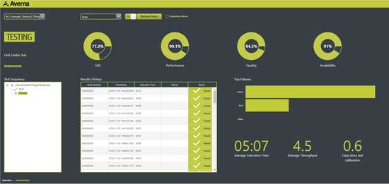
Averna has launched a series of development tools that enable the real-time monitoring of assets.
The Averna ConnexThing Toolkits enable customers to quickly connect new and existing manufacturing test assets to PTC’s ThingWorx Industrial IoT Platform.
Each toolkit targets a specific programming language or test sequencer to accelerate the implementation and deployment of an internet of things (IoT) solution with ThingWorx.
The ConnexThing Toolkit for NI TestStand, which is available for download now, streamlines the connection between TestStand’s ready-to-run test management software and ThingWorx’s innovative end-to-end IoT platform. It comes complete with templates, data shapes, widgets and dashboard examples that easily link test stations.
The ConnexThing Toolkit for NI TestStand:
accelerates integration of ThingWorx with TestStand
enables easy monitoring of test stations and asset management using the configurable ThingWorx dashboard tool
orchestrates bi-directional communication
provides guidance for clean code and architecture.
“The Averna ConnexThing Toolkit is the first in a series of new operational technology (OT) solutions designed to help clients gain insight on manufacturing and test processes and deploy Smart Connected Operations,” said Jean-Levy Beaudoin, VP Platforms & Innovation for Averna. “By leveraging the power of PTC’s ThingWorx Industrial IoT Platform together with our test assembly automation and machine vision expertise, Averna is uniquely qualified to help organizations achieve their digital transformation, enabling further productivity and quality improvement.”
“PTC is pleased to have Averna in the PTC Partner Network, allowing for their recognized quality and test expertise to be made readily available to ThingWorx customers,” said JP Provencher, vice president of manufacturing strategy and solutions at PTC. “The ThingWorx extensions they have built help manufacturing companies improve test and quality processes by making them connected, real-time, predictive, and augmented.”
The Averna ConnexThing for NI TestStand is available to download now as a free 90-day trial, directly from the PTC Marketplace or Averna website.
Taoglas, a provider of internet of things (IoT) and automotive antenna and RF solutions, completed its acquisition of ThinkWireless Inc., an antenna provider that specializes in the design, development and production of combination antenna systems for the commercial vehicle market.
The ThinkWireless brand will become ThinkWireless, a Taoglas company. ThinkWireless Founder and Chief Executive Officer Argy Petros and Director of RF Technology Pierre Wassom will remain.
“Think Wireless has made a name for itself as a designer and developer of high-quality combination antenna systems with deep roots in the commercial trucking industry, where infotainment services, including good quality of service from satellite and AM/FM radio, weather band and GNSS are crucial,” said Ronan Quinlan, Co-CEO, Taoglas.
“As we continue to explore potential acquisitions to strengthen the Taoglas brand, we were struck by how similar Think Wireless’ approach to antenna design and manufacturing is to our own commitment to excellence,” Quinlan said. “This is a great acquisition for the Taoglas Group as we look to further expand into new, synergistic markets such as the commercial vehicle industry.”
ThinkWireless, headquartered in Coconut Creek, Florida, specializes in the design, development and production of combination antenna systems that incorporate two or more frequency bands, including those for SiriusXM satellite radio, GPS, AM/FM, weather band, DAB, HDTV, Wi-Fi, Bluetooth and LTE.
The ThinkWireless facilities will become Taoglas’ ninth design and development center globally, and the third in the U.S., alongside centers in San Diego and Minneapolis.
“Taoglas is well-known as a global brand that delivers the highest-quality antennas and RF solutions to the automotive, IoT and other markets,” Petros said. “Taoglas’ global scale and sales channels are unparalleled and will help grow the reach of ThinkWireless’ solutions in the trucking and commercial vehicle industry around the world.”
The ThinkWireless antennas will be available for purchase on the Taoglas website, through key distribution partners and through Taoglas’ Antenna Builder e-commerce marketplace for custom antennas and cable assemblies.
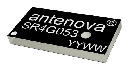
Antenova Ltd. has developed a new positioning antenna that it says can pinpoint a location to within centimeters in the GNSS bands. Antenova is a manufacturer of antennas and RF antenna modules for machine-to-machine and the internet of things.
Antenova will be showing samples of the Raptor antenna at the Consumer Electronics Show, being held Jan. 8-11 in Las Vegas, in booth #2220 in the Westgate hall.
The Raptor antenna utilizes the L2 1200-MHz satellite band that recently became available for civilian use.
The addition of the L2 frequency band combines multi-band satellite signal reception and GNSS correction data. This helps to mitigate position errors, greatly improving accuracy, especially in urban areas, the company said.
As well as improving tracking, the L2 band is beneficial for UAVs, drones, autonomous vehicles, agriculture, grid mapping and other emerging applications, Antenova added.
The antenna is the latest addition to Antenova’s lamiiANT range of rigid FR4 antennas which are designed for easy insertion onto a printed circuit board (PCB).
The antenna itself is very small. It is a GPS single-feed antenna in surface mount (SMD) form, measuring 16.0 x 8.0 x 1.6 millimeters, suitable for small PCBs within all kinds of small electronic devices.
“This is an outstanding antenna, because it achieves the same precision as a much larger, heavier ceramic patch antenna, but in a very compact SMD part,” said Colin Newman, CEO of Antenova. “A ceramic antenna would need to be 35 x 35 millimeters to achieve a similar level of accuracy and performance.” Raptor is supplied in tape and reel for ease in high-volume manufacturing applications.
Bentley Systems has entered an agreement to acquire Quebec City-based AIworx, provider of machine learning and internet of things (IoT) technologies and services.
Bentley Systems is the leading global provider of software solutions to engineers, architects, geospatial professionals, constructors, and owner-operators for the design, construction, and operations of infrastructure.
The addition of AIworx brings advancements in data collection and analysis to leverage infrastructure engineering digital twins, continuously updated with real-time contextual information, to optimize productivity, operations and maintenance, Bentley Systems said.
Bentley Systems also announced the acquisition of ACE enterprise Slovakia, provider of innovative technology solutions to interface with enterprise resource planning (ERP), enterprise asset management (EAM), and geographical information systems. ACE enterprise has been a technology partner of Bentley Systems, and the ACE Enterprise Platform is used for the Bentley AssetWise connector that is certified for both SAP ERP and SAP HANA.
AIworx machine learning and IoT technologies leverage digital twins’ analytics visibility for infrastructure asset performance. (Image: Bentley Systems)
“AIworx has been providing machine learning and IoT technologies and services to help organizations generate, understand, and act on data so they can make better business decisions,” said Andre Villemaire, co-founder and president of AIworx.
“The biggest opportunities we’ve worked on have to do with improving infrastructure asset performance on an industrial scale, by way of the data from connected machines, instrumentation, sensors, and communications systems — and we’re excited to dedicate ourselves to that advancement,” Villemaire continued. “Now, by incorporating our tools into Bentley’s services for digital twins, we enable infrastructure operators to multiply the potential benefits of machine learning and IoT.”
“Machine learning and IoT technologies have created the opportunity for profound improvements in productivity and efficiency of infrastructure,” said Francois Valois, vice president of portfolio development for Bentley Systems. “Our new colleagues from AIworx have already been delivering on this potential, and now, leveraging the analytics visibility, which Bentley’s digital twin cloud services uniquely provide, these advancements from going digital will accelerate exponentially.”
Alexander Cimbalak, founder of ACE enterprise, said, “We have enjoyed our partnership with Bentley to provide enterprise connectors and are very excited to be part of Bentley and also now to enable Bentley’s digital twin cloud services to uniquely synchronize with infrastructure assets’ enterprise IT, OT, and ET data sources.”
Alan Kiraly, senior vice president, asset performance for Bentley Systems, said, “ACE enterprise has consistently overcome IT interoperability challenges for us at Bentley. Now, as colleagues, this talented team will enable us to continue to expand the scope and breadth of information that can be accessed through AssetWise and digitally aligned within infrastructure digital twins.”
The device combines u-blox GNSS, 4G and Wi-Fi technology, eliminating the need to equip vehicles with a separate mobile Wi‑Fi hotspot.
According to the companies, the StartLink TrackerWi‑Fi is suitable for applications for connected cars, telematics, vehicle diagnostics, fleet management, vehicle security, usage-based insurance, and rental and leasing service companies.
The internet of things (IoT) and connected-car initiatives are providing rental car companies and transportation and logistics firms with tools to track vehicles, preemptively detect and diagnose disturbances from a distance, and monitor the behavior of their drivers in real time. ERM has more than 1.8 million vehicle fleet-tracking devices deployed on roads world-wide.
As onboard Wi‑Fi becomes increasingly widespread, many companies are fitting vehicles with Wi‑Fi hotspots to offer drivers and passengers internet access. With its integrated Wi‑Fi hotspot, ERM’s StarLink TrackerWi‑Fi lets users tap into the cellular 4G connectivity to transfer telematics data to the fleet manager. This makes it possible to send real-time telematics data to the driver’s smart device or onboard infotainment system, and it also reduces the number of SIM cards needed from one per device to one per vehicle.
Sourcing the GNSS tracking, cellular 4G LTE, and Wi‑Fi technology from u-blox played a key role in achieving the device’s fast time to market. By using u‑blox’s pre-tested positioning and communications modules with integrated software, the manufacturer was able to cut the time needed for production and development by several months.
“We saw an opportunity to provide more values to our customers by adding Wi‑Fi hot spot functionality to our StarLink Tracker, our leading telematics product, but knew that we had to be quick to stay ahead of the game,” said Kfir Lavi, senior vice president of ERM Advanced Telematics.
“Our partners are always at the top of our priorities, and we are working to adapt our offerings to the market demands and the changing needs of their customers. Working with u‑blox as the provider of the positioning and wireless communication technology helped us move from concept to commercialization in under six months and provide our partners with an advanced product in a short time,” Lavi said.
“This successful collaboration demonstrates that we have evolved from a provider of individual technologies, namely GNSS positioning, cellular 4G connectivity, or short range radio communication, to a provider of solutions that bundle these technologies,” said Thomas Seiler, CEO of u-blox. “We are seeing increased demand for such bundled solutions and are convinced that the close integration of our technology portfolio offers our customers the unique ability to jump-start even challenging projects on extremely short notice.”
The second edition of the European GNSS Agency’s (GSA) GNSS User Technology Report has been published and is now available for free download, providing an exhaustive review of the latest GNSS trends and developments.
Since its launch in 2016, the GNSS User Technology Report has become the go-to-source for information on the dynamic, global GNSS technology industry.
The GNSS User Technology Report, a sister publication to the GSA’s GNSS Market Report, is published every two years and takes an in-depth look at the latest state-of-the-art GNSS receiver technology, along with providing expert analysis on the trends that will shape the global GNSS landscape in the coming years.
Three key segments
European GNSS Agency
Like the inaugural report in 2016, the second issue focuses on three key macro segments: mass market solutions; transport safety- and liability-critical solutions; and high precision, timing and asset management solutions.
The report opens with an overview of the latest developments and trends in GNSS, with a focus on the multi-constellation and multi-frequency that are driving new trends in the sector.
“With the GNSS User Technology Report, our aim is to provide everybody in the GNSS value chain with a comprehensive overview of the current landscape in the industry and to identify new trends so that stakeholders know in which direction the industry is moving,” GSA Executive Director Carlo des Dorides said.
“The most important new trend identified in this issue is the rapid adoption of multiple frequencies, including for consumer devices, as evidenced by the market introduction of the first dual-frequency smartphone in May 2018,” des Dorides said.
Editor’s special section: Automation
The final section in this year’s report — the “Editor’s special” section — is dedicated to automation and to the increasingly important role GNSS plays in a number of partially — or fully automated tasks and functions. The most publicised examples of these are found in the transport domain — driverless cars, autonomous vessels and drones but, as the report notes, GNSS-based automation applications go well beyond transport.
The analysis of GNSS user technology trends in the report is supported by testimonials from key suppliers of receiver technology, including: Broadcom, Javad, Kongsberg, Leica, Maxim Integrated, Meinberg, NovAtel, Orolia-Spectracom, Qualcomm, Septentrio, STMicroelectronics, Thales, Trimble and u-blox.
In addition, the report includes highlights from around 20 ongoing research projects from the Horizon 2020 and Fundamental Elements programmes, aiming at the development of GNSS receiver technology.
The full GNSS User Technology Report 2018 is available for download here.
GNSS User Technology Report 2018 Highlights
All global and regional GNSS constellations are developing, modernising and innovating, with more than 100 GNSS satellites now available over our heads.
The vast majority of current receivers are multi-constellation, and the most popular way to provide multi-constellation support is to cover all available constellations. Today only around 30% of receivers use GPS only.
In the mass market domain, we are seeing a divide between chipsets optimised for entry-level internet of things (IoT) products, where energy per fix is the primary driver, and high end, where the industry is innovating to propose enhanced positioning performance.
The need for accuracy in the mass market is initiating new solutions, including ones based on Android GNSS raw measurements or, more significantly, using multi-frequency signals.
The frequencies supported across all application areas range from single L1/E1 to 4 frequencies in the professional segment. The dual frequency solution showing the most growth is L1/E1 and L5/E5, however the legacy L1/E1 and L2 are still being used.
Growing interest has been observed in PPP and RTK services proposed by private industry and public system operators, leading to new PPP/RTK concepts aiming to address a wide customer base beyond high precision.
The need to ensure both safety and security of PNT solutions is being highlighted by all solution providers, particularly in systems where humans are out of the control loop, such as in autonomous vessels, cars or drones.