Image: U.S. Department of Defense / Raytheon Technologies
Raytheon Technologies has delivered all 23 contracted Joint Precision Approach and Landing Systems (JPALS) low-rate production units to the U.S. Navy to ship to Japan. Raytheon announced the contract with the Navy back in February to provide JPALS to the Japan Maritime Self-Defense Force (JMSDF), which will be deployed on the JMSDF JS Izumo carrier in 2024.
JPALS is a software-based GPS navigation and precision approach landing system that guides aircraft onto carriers and amphibious assault ships regardless of sea state or weather conditions, bolstering safety and operational capability.
JPALS is deployed on all U.S. Navy aircraft carriers and amphibious assault ships, as well as all F-35 aircraft. In addition, JPALS are deployed on platforms from two countries: the UK Royal Navy’s HMS Queen Elizabeth, and the ITS Cavour, an Italian aircraft carrier, to support their F-35 squadrons.
Raytheon has also developed an expeditionary variant of JPALS called eJPALS, which is a smaller, portable system that could be packaged in ruggedized cases, mounted on small vehicles, and deployed in austere, remote locations for precision landings. The system could establish up to 50 different landing points within a 20-nautical-mile radius.
“Seen & Heard” is a monthly feature of GPS World magazine, traveling the world to capture interesting and unusual news stories involving the GNSS/PNT industry.
Image: BanksPhotos/E+/Getty Images
Dozens Stranded in Tundra
Several vehicles in Rock Springs, Wyoming, were stranded after being led by their map apps or vehicle navigation systems to an unmaintained county road in a blizzard. Several calls were made to the Sweetwater County Sheriff’s Office about stranded vehicles stuck after they were directed to the detour when Interstate 80 was closed due to winter conditions. Similar incidents were reported by other counties, resulting in discussions between the Wyoming Department of Transportation and the companies that develop navigation software.
Screenshot: CBS video
UAVs contain Western Technology
A Ukrainian intelligence assessment obtained by CNN and CBS reported an Iranian UAV downed in Ukraine contained technology from companies in the United States and other western countries. The White House has since launched an investigation as to how the technology — including semiconductors, GPS modules and engines — were obtained by Iran. The components removed from an Iranian Shahed-136 UAV totaled 52, 40 of which were manufactured by 13 different U.S. companies. The remaining components were manufactured by other western companies and by companies based in Japan, Taiwan and China.
Researchers may now be able to monitor climate-induced natural hazards by combining satellite technology with machine learning. Researchers were able to use machine learning to study hurricanes that made landfall over the Gulf of Mexico in a series of recent experiments. C.K. Shum, the co-author of the study and a professor at the Byrd Polar Research Center, uses geodesy to study global climate change phenomena. Using geodetic data gathered from satellites, Shum tested whether a mix of remote sensing and machine learning analytics could accurately monitor weather phenomena. Accurate measurements could help improve hurricane forecasting.
Sailboat. (Image: valio84sl/iStock / Getty)
The power of TikTok is real
TikTok changed Jeff Foulk’s life when his daughter posted about his free marine navigation app, Argo, when they attended a boat show in Chicago. Foulk was promoting Argo with little success, until his daughter shared with the social media platform his struggle as the owner of a small business. Since then, the app has been downloaded more than 200,000 times and remains at the top of the charts for boat navigation apps. Argo was launched more than four years ago and, until now, had only 100,000 total downloads. Now that Argo is viral, Foulk wants to launch a premium subscription.
Raytheon Intelligence and Space has been awarded a contract from the United States Navy’s Naval Air Traffic Management Systems Program Office to deliver the Joint Precision Approach and Landing Systems (JPALS) to the Japan Maritime Self-Defense Force (JMSDF). The GPS navigation and precision landing system will be deployed on the JMSDF JS Izumo carrier.
The JPALS system guides aircraft onto carriers and assault ships in all weather and surface conditions and is integrated on all F-35 aircraft. JPALS is also being deployed on all U.S. Navy aircraft and assault ships.
In addition, JPALS will be deployed on two international platforms, including the United Kingdom Royal Navy’s HMS Queen Elizabeth, and an Italian aircraft carrier, the ITS Cavour, to support its F-35 squadron.
The primary work locations for JPALS are in Largo, Florida and Fullerton, California.
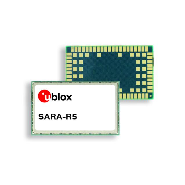
U-blox’s SARA-R5 series LTE-M module, based on the company’s low-power wide-area (LPWA) chipset, has been fully certified on all mobile network operators’ LTE-M networks in Japan. The module is the first u-blox internet of things (IoT) product to receive certification with all the Japanese operators.
The SARA-R5 series is 5G-ready and aimed at LPWA IoT applications such as industrial automation, sensor applications, connected health, metering, asset and vehicle tracing, and telematics. The module is also certified Microsoft Azure and qualified for IoT Core Amazon Web Services.
The SARA-R5 series has three product variants including the SARA-R500S-61B, the SARA-R510M8S-61B and the SARA-R510S-61B.
The SARA-R500S-61B offers standard LTE-M connectivity. The SARA-R510M8S-61B includes an integrated u-blox M8 GNSS receiver and a separate GNSS antenna interface, which provides reliable and accurate positioning data concurrent to LTE communication. This module is suitable for mobile applications such as automotive, fleet management and tracking, and telematics.
The SARA-R510S-61B is designed for low-battery powered applications including metering, security and surveillance, remote monitoring and more.
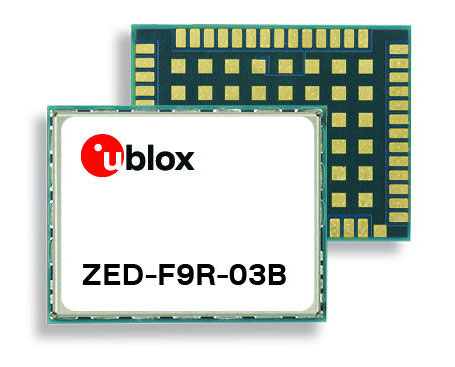
U-blox has released a new firmware update for its ZED-F9R high-precision GNSS dead-reckoning modules. The update extends the range of supported positioning augmentation services.
With the update, the u-blox ZED-F9R-03B adds support for Japan’s QZSS CLAS correction services, extending the geographical market reach of the ZED-F9R and increasing the scalability of applications using the module. It also now supports SPARTN 2.0, a service from u-blox that delivers correction data based on the SPARTN protocol.
The ZED-F9R module was designed for use in autonomous automotive and industrial applications that require simple and efficient implementation. It is used where rapid access to highly accurate positioning data is key, even in challenging signal environments such as dense cities. Typical applications include slow-moving use cases such as robotic lawnmowers and shared e-scooters.
The module has an integrated inertial measurement unit (IMU) for real-time kinematic (RTK) positioning. It employs sophisticated algorithms to fuse the IMU data with GNSS measurements, wheel ticks, correction service data, and a vehicle dynamics model to provide centimeter-level positioning accuracy even in situations where GNSS alone would fail. It is based on the u-blox F9 multi-band GNSS receiver platform, which concurrently tracks up to four GNSS constellations, providing high-quality positioning accuracy.
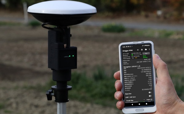
BizStation, a database company based in Japan, and u-blox have announced a highly accurate, compact and low-cost high-precision positioning solution for markets in East Asia and Oceania.
Featuring two u-blox modules, the solution delivers centimeter-level positioning accuracy where mobile network service is unavailable, including in maritime offshore surveying, agricultural and industrial vehicle guidance, and UAVs.
BizStation’s precise point positioning (PPP) system covers all territories served by Japan’s Quasi-Zenith Satellite System (QZSS) MADOCA correction service.
The solution leverages the strengths of two u-blox components. The first, a u-blox ZED-F9P multi-band high precision GNSS receiver module, is at the heart of BizStation’s DG-PRO1RWS GNSS receiver.
The second, a u-blox NEO-D9C correction-data receiver module specific to Japan, enables their virtual reference station to receive data on the QZSS L6E-band used by MADOCA.
The PPM (PPP positioning by MADOCA) Android application developed by BizStation then determines the location of the tracked device using the high-precision positioning data transferred via Wi-Fi from BizStation’s DG-PRO1RWS GNSS receiver as well as GNSS correction data from the virtual reference station. The PPM application performs all required calculations using the MADOCA positioning library developed by NEC Solution Innovators Co., Ltd.
The high-precision GNSS solution can be deployed either using a static or a mobile virtual reference station for a wide range of applications such as agriculture, drones, motor sports or surveying systems.
Mitsubishi Electric Corp. has completed initial verification of the functions and performance of equipment aboard the orbiting QZS-1R satellite.
QZS-1R was launched Oct. 26, 2021, from Tanegashima Island in Kagoshima Prefecture and is now in quasi-zenith orbit as the successor to the original Quasi-Zenith Satellite (QZS-1), nicknamed Michibiki.
Logo and patch for the QZS-R1 satellite (Image: Miitsubishi Electric).
With Quasi-Zenith Satellite System services also having completed testing of related ground systems, the Cabinet Office will begin launching various positioning services via the QZS-1R today.
Mitsubishi Electric built and delivered QZS-R1 to the Cabinet Office of Japan. In addition to supporting these services, Mitsubishi Electric will continue developing satellite systems for forthcoming satellites QZS-5 to QZS-7, which will support advanced, sustainable, high-precision positioning in Japan.
Compared to the first Michibiki satellite, the QZS-1R has improved durability that is expected to extend the satellite’s design life by about five years compared to its predecessor. QZS-1R, together with QZS-2, 3 and 4 (all launched in 2017), will support positioning, high-precision positioning augmentation and other satellite services.
Name
QZS-1R
Mass
Dry mass (i.e., without propellant): approx. 1.6 tons; at launch: approx. 4.0 tons
Dimensions
Stowed: approx. 5.4m x 2.9m x 2.9m; wing span: approx. 19m
“Seen & Heard” is a monthly feature of GPS World magazine, traveling the world to capture interesting and unusual news stories involving the GNSS/PNT industry.
Photo: Anton Rodionov/iStock/Getty Images Plus
UNWANTED HITCHHIKERS
Antarctica’s pristine marine ecosystem, isolated for 15–30 million years, could be threatened by species such as mussels, barnacles, crabs and algae arriving on ships from 1,500 ports worldwide. A research team from the British Antarctic Survey and the University of Cambridge used automatic identification system (AIS) data, which relies on GNSS navigation data, and shipping databases to determine traffic to the Antarctic. The study is published in the Proceedings of the National Academy of Sciences, January 2022.
Photo: FrankRamspott/iStock/Getty Images Plus
QUAKE PREDICTION
Within the next 30 years, a highly destructive Nankai Trough megathrust earthquake is predicted to hit southwest Japan. Understanding long-term slow slip events under the Bungo Channel is essential for pinpointing when such an earthquake will happen. Kobe University’s Yoshioka Shoichi and Seshimo Yukinari analyzed the 2018–2019 Bungo Channel slow-slip event using longitudinal GNSS data provided by the Geospatial Information Authority of Japan. The data revealed that even though the 2018–2019 event was shorter than others, it was bigger in terms of slippage and slip velocity, as well as magnitude. Results appear in Scientific Reports, Jan. 10, 2022.
Photo: Bluesky
SUPPORTING SOLAR
British aerial mapping company Bluesky is helping Derby Homes roll out integrated solar photovoltaic systems across its housing stock. A project to identify suitable roof coverings assessed more than 8,000 addresses for size, pitch, aspect, existing structures and infringing vegetation. Using its ultra-high-resolution imagery, Bluesky determined the solar suitability of each property, the number of panels needed, and their potential output. Derby Homes recently installed its first integrated solar array on an initial batch of trial properties identified by Bluesky.
Photo: JohnCarnemolla/iStock/Getty Images Plus
TAKING MOM TIME
CQUniversity’s precision livestock management research team is using GNSS to detect calving events in extensive grazing herds. The discovery could provide beef producers in Australia with a way to remotely monitor their cattle and improve calf survival rates, one of their biggest challenges. The research project used GNSS collars with motion-detecting accelerometers on 30 cows in a 28-hectare paddock over an eight-week period at Belmont Research Station. The collars captured the animals’ location information every 10 minutes. Because the distance between mother and herd increases during calving, the data helped predict calving events, which were then visually confirmed by the research team.
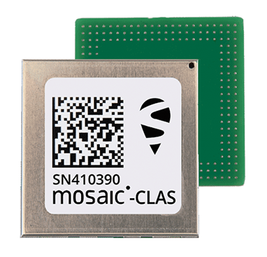
Septentrio, a leader in high-precision GNSS positioning solutions, has launched three new products that support Japan’s high-accuracy Centimeter Level Augmentation Service (CLAS).
The three multi-frequency GNSS receivers support CLAS on a single device, thanks to the latest GNSS technology which receives the L6 signal, which transmits high-accuracy corrections from Japan’s QZSS constellation. This technology was developed in close cooperation with CORE, a leading integrator of high-accuracy positioning technology and services in Japan.
The mosaic-CLAS receiver is a GNSS module with a very small form-factor suitable for high-volume industrial applications.
The AsteRx-m3 CLAS is Septentrio’s best-in-class OEM board combining PPP-RTK CLAS with dual-antenna heading functionality.
The AsteRx SB3 CLAS features a ruggedized IP68 enclosure to protect it in harsh environments.
Septentrio is simultaneously offering various receiver types to the Japanese market ensuring an optimal match between products and customer needs in various applications including robotics, precision agriculture, construction, machine control and UAV.
“We are very pleased to jointly develop CLAS software on a new GNSS module, mosaic-CLAS,” emphasized Takahiro Yamamoto, director, GNSS Solution Business Center at CORE Corp. “This receiver puts CLAS GNSS technology on par with regular RTK receivers in terms of size as well as price. We believe that the realization of CLAS on the Septentrio mosaic platform will significantly promote the use of new QZSS services for industrial applications.”
“The launch of our new module and OEM board with CLAS support opens up new markets and use cases, which will benefit from centimeter-level positioning with fast acquisition time,” commented François Freulon, head of Product Management at Septentrio. “This launch demonstrates the technological leadership of Septentrio and our ability to provide dedicated solutions embedding L6 bands for the Japanese market.”
The CLAS PPP-RTK is the latest generation of GNSS correction services, combining near-RTK accuracy and quick initialization times with the broadcast nature of PPP. Receivers with built-in CLAS functionality offer sub-decimeter positioning accuracy right out of the box. Corrections for high-accuracy positioning are received directly from satellites, reducing the need for additional base stations or service subscriptions.
Find out more about PPP-RTK and other positioning correction methods in the insight article GNSS Correction Demystified.
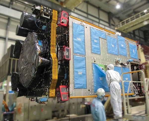
QZS-R1 is prepped for testing. At left is the Earth-oriented surface that hosts the L-band antenna. (Photo: JAXA)
By Peter Steigenberger, Steffen Thoelert, Sergei Yudanov and Markus Ramatschi
The Japanese QZS-1R satellite was launched on Oct. 26, 2021, from the Tanegashima Space Center in Japan. It serves as a replenishment for QZS-1, the first spacecraft of the Japanese Quasi-Zenith Satellite System (QZSS) in orbit since September 2010.
QZS-1R joins the current QZSS constellation of three satellites in inclined geosynchronous orbit (IGSO) and one geostationary satellite. These four Block I satellites transmit the L1C/A signal at 1575.42 MHz.
QZS-1R, as well as future QZSS satellites, are able to transmit the new L1C/B signal. L1C/B is based on the same family of gold codes as L1C/A, but uses a binary offset carrier (BOC) modulation instead of the binary phase-shift keying (BPSK) and a different PRN range (203–206).
Compared to BPSK, the BOC modulation adds a square wave subcarrier with a frequency of fsc = 1.023 MHz that equals the chipping rate of the ranging code. This subcarrier shifts the peak spectral energy from the center frequency fL1 to fL1 ± fsc to reduce interference with the GPS L1C/A signals.
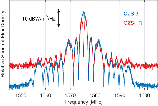
During in-orbit testing (IOT) from late November until early December 2021, QZS-1R transmitted L1C/A and L1C/B signals intermittently. FIGURE 1 shows a spectrum of the L1-band transmissions of QZS-1R recorded on Nov. 25 with the 30-meter dish antenna of the German Space Operations Center in Weilheim, Germany, as well as a spectrum of QZS-2 recorded in July 2017.
Figure 1. L1 spectra of QZS-1R (red) transmitting L1C/B and L1C, as well as QZS-2 (blue) transmitting L1C/A and L1C. The spectra were measured with DLR’s 30-meter high-gain antenna on Nov. 25, 2021, and July 20, 2017, respectively. (Credit: DLR)
During IOT, QZS-1R had an extremely low maximum elevation of 0.8° in Weilheim. Due to technical restrictions for such low elevations, QZS-1R had to be observed with a sidelobe of the 30-meter antenna. As a result, the respective observations are much more noisy than the QZS-2 reference data.
Nevertheless, the different spectral characteristics of L1C/B and L1C/A can be clearly seen in FIGURE 1: L1C/B has two maxima at 1574.4 and 1576.5 MHz due to the BOC modulation, whereas the BPSK L1C/A signal has one maximum at the center frequency of 1575.42 MHz.
GNSS receivers of the International GNSS Service (IGS) started to track L1C/A, L1C, L2C and L5 signals of QZS-1R on Nov. 17. Aside from the regular PRN code J04, test signals using the non-standard code PRN J06 were intermittently transmitted by QZS-1R during the IOT and tracked by these receivers.
Based on the public specification of the new L1C/B signal, Javad GNSS developed a prototype firmware that enabled tracking of this signal during the early transmissions. This firmware was installed on a Javad TRE-3 receiver operated by GFZ German Research Centre for Geosciences at its IGS station WUH200CHN in Wuhan, China.
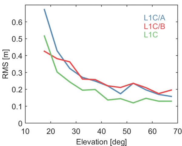
FIGURE 2 illustrates the noise and multipath characteristics of different QZS-1R pseudorange measurements. It is based on the so-called multipath linear combination of L1 pseudorange and L1/L2 carrier-phase observations covering a six-hour data arc. RMS values were computed for 5-degree elevation bins for each pseudorange signal. While the individual signals were tracked on different days of the IOT and the associated results have to be interpreted with care, the data indicate a very similar ranging performance of the legacy C/A signal and the new C/B signal. Best results are obtained with the L1C signal, which uses both a higher signal power and an advanced modulation with superior multipath suppression.
Figure 2. Noise and multipath characteristics of QZS-1R signals on the L1 frequency tracked by the IGS station WUH200CHN in Wuhan, China. (Credit: DLR)
QZS-1R will resume continuous transmission of L1C/A as soon as declared healthy. The transition from L1C/A to L1C/B is planned for 2023-2024, when an operational QZSS constellation of seven satellites is reached. The launches of the IGSO satellite QZS-5, the geostationary QZS-6, and the quasi-geostationary QZS-7 are all planned for 2023.
GNSS data used in this article were collected with a Javad GNSS TRE-3 receiver. The spectral overviews were captured with a Rohde & Schwarz FSQ26 signal analyzer.
Peter Steigenberger is a senior scientist at the German Space Operations Center of the German Aerospace Center (DLR), where he conducts research in the field of new satellite navigation systems.
Steffen Thoelert is an electrical engineer at DLR’s Institute of Communications and Navigation. His research activities focus on signal-quality monitoring and satellite payload characterization.
Sergei Yudanov is a senior firmware developer at Javad GNSS, Moscow. His main field of activity is GNSS signal processing.
Markus Ramatschi is a senior scientist at the Helmholtz Centre Potsdam, GFZ German Research Centre for Geoscience. He is operating a global GNSS reference station network.
Ramatschi M., Bradke M., Nischan T., Männel B. (2019): “GNSS data of the global GFZ tracking network,” vol 1. GFZ Data Services. https://doi.org/10.5880/GFZ.1.1.2020.001
SoftBank Corp., ALES Corp. and u-blox AG have signed a memorandum of understanding to cooperate in GNSS augmentation services for global markets.
SoftBank provides the “ichimill” GNSS augmentation service in Japan, its subsidiary ALES operates a business that generates and delivers positioning correction data, and u-blox is a global provider of positioning services for the automotive, industrial and consumer markets.
U-blox also provides electronic components for wireless communications and the PointPerfect GNSS augmentation service in Europe, the United States and other countries and regions.
Through this business collaboration, SoftBank, ALES and u-blox will construct GNSS augmentation infrastructure for Japan, Europe and the United States, develop GNSS receivers and devices, and expand service areas.
Collaboration Background
Since November 2019, SoftBank has been offering ichimill, a GNSS augmentation service that offers highly accurate positioning with a margin of error of a few centimeters in the Japan market. In addition to providing technology that enables the generation and delivery of correction data, ALES has been offering a centimeter-level positioning service to consumers in Japan since August 2020.
In July 2021, u-blox began providing PointPerfect, a PPP-RTK-based GNSS augmentation service, which is now available in the contiguous United States and Europe.
GNSS augmentation services like these are mainly offered separately by country and region. Client companies, which include global automotive manufacturers and agricultural machinery manufacturers, sign up for separate service contracts in each country and region, making GNSS receiver configuration more complex.
Collaboration Overview
To offer global GNSS augmentation services, SoftBank, ALES and u-blox will study the following initiatives.
Develop a global correction data delivery infrastructure. GNSS augmentation services use correction methods that differ by country and region, and there is a wide variety of correction signal formats. In 2022, the three companies will consider developing a correction data delivery infrastructure that delivers unified correction signal formats for use in any country or region. With this infrastructure, companies using ichimill or PointPerfect will be able to conduct GNSS augmentation if they are in range of both services, which will eliminate the need for separate service contracts by country or region.
Jointly develop global-compatible devices. In addition to correction data delivery, an environment that allows for the easy implementation of GNSS receivers and other devices is necessary for GNSS augmentation services. In conjunction with the launch of ichimill, SoftBank developed its own GNSS receivers and is offering them in Japan. The three companies will consider jointly developing GNSS receivers and modules that can be used globally.
Greater GNSS augmentation accuracy and service area expansion. The companies will collaborate closely to ensure that the performance of the services in all the regions covered are comparable. This is important to provide a consistent customer experience across all regions. Furthermore, the three companies plan to study service expansion into other areas, including Asia. SoftBank is promoting the deployment of non-terrestrial network (NTN) solutions that encompass satellite- and stratospheric-based telecommunication platforms to provide connectivity to the sea, the sky, developing countries and rural areas lacking internet infrastructure so everyone around the world has access to the internet. The three companies will consider the development of NTN-linked services, such as correction data delivery using small amounts of data in a way that is suitable for NTN bandwidths.
The successor to the first quasi-zenith satellite, dubbed Michibiki, is expected to launch this year.
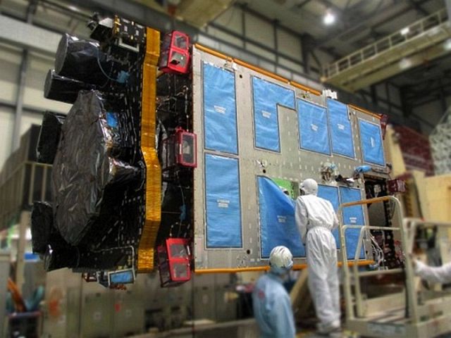
Michibiki was launched by the Japan Aerospace Exploration Agency (JAXA) in September 2010 and was transferred to the Cabinet Office in 2017. The replacement satellite is now undergoing prototype testing at the satellite manufacturer’s facility(Mitsubishi Electric Co. Ltd. Kamakura Seisakusho) in Kanagawa.
The tests will confirm performance of the replacement satellite before it is put into service. It is undergoing acousitic, vibration and thermal vacuum tests to ensure it will remain functional after launch and in space.
After testing, the satellite will be transported to the Tanegashima Space Center for launch, which is expected to take place later this year.
Replacement for Michibiki: The L-band antenna that transmits the positioning signal is mounted on the Earth-oriented left side. (Photo: JAXA)
Though built to succeed the first QZSS satellite, the replacement is based on the second and fourth satellites
Main specifications of the successor to the first satellite and other satellites:
item
First machine
Units 2 and 4
Unit 3
Successor to the first machine
Orbit
Quasi-zenith
Quasi-zenith
Rest
Quasi-zenith
Positioning signal
L1-C / A,
L1C, L1S,
L2C, L5, L6
L1-C / A, L1C,
L1S, L2C,
L5, L5S, L6
L1-C / A, L1C,
L1S, L1Sb, L2C,
L5, L5S, L6
L1-C / A
(L1-C / B (* 1)),
L1C, L1S, L2C,
L5, L5S, L6
L band antenna
Helical method
(* 2)
Helical method
(* 2)
Patch method
(* 3)
Patch method
(* 3)
Generated power
5.3kW
6.3kW
6.3kW
6.3kW
mass
About 4t
About 4t
About 4.7t
About 4t
Design life
10 years or more
Over 15 years
Over 15 years
Over 15 years
Launch year
2010
2017
2017
2021
(planned)
Launch
rocket
H2A202
H2A202
H2A204
H2A202
(* 1) Signal transmitted by BOC (Binary Offset Carrier) modulation of L1-C / A code
(* 2) Antenna with spiral antenna elements arranged
(* 3) Antenna with planar antenna elements arranged