Low-Earth-orbit signals add increased signal strength, geometry diversity and robustness to GNSS.
U-blox, a global leader in positioning and short-range communication technologies for automotive, industrial and consumer markets, is exploring how the introduction of low-Earth-orbit (LEO) signals can complement and integrate with existing GNSS to support mass-market positioning solutions.
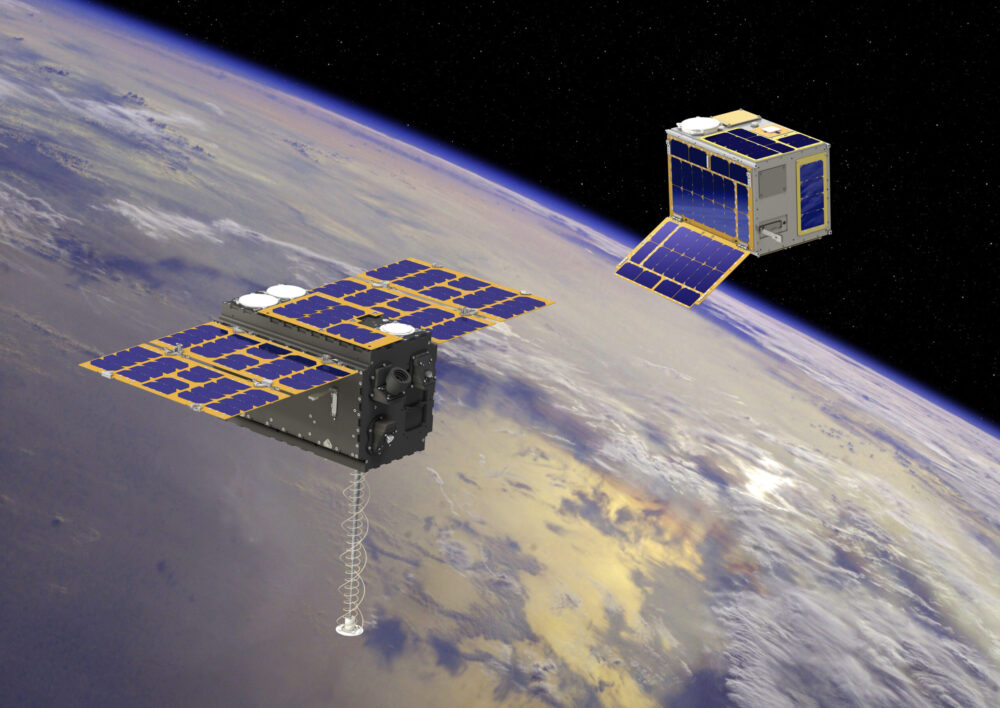
The announcement comes following the launch of the European Space Agency’s (ESA) first Celeste LEO-PNT demonstration satellites (IOD-1 and IOD-2) on 28 March 2026, marking a key milestone in bringing LEO-based signals into the operational positioning environment and ESA’s first step toward extending satellite navigation into low Earth orbit.
As the positioning ecosystem evolves, LEO-based signals are emerging as a complementary layer to established GNSS. Designed to augment systems such as Galileo, LEO satellites introduce a new building block characterized by lower orbital altitude, increased signal strength, and rapidly changing satellite geometry. GNSS remains the foundation of global positioning, delivering proven coverage and consistency at scale.
This evolution is not only about additional signals, but about how positioning systems behave over time. The dynamic geometry of LEO satellites introduces new system characteristics that influence convergence speed, robustness, and performance in challenging signal conditions.
Under its Navigation Innovation and Support Program (NAVISP) Element 2 (EL2) project, co-funded by ESA, u-blox is conducting a technical assessment of the role of LEO signals in multi-layer positioning architectures. This work forms part of a broader effort to bring LEO-PNT capabilities to mass-market GNSS receivers, combining emerging LEO signals with established GNSS systems.
This includes early integration work on u-blox’s X20 GNSS platform, exploring how different signal types and frequency bands can be optimally incorporated into u-blox’s positioning systems. The scope of work includes:
Observation and characterization of emerging LEO signal transmissions
Analysis of interactions between LEO signals and GNSS measurements
Evaluation of the impact of dynamic satellite geometry on positioning performance
Exploring different system-level approaches for integrating LEO signals into future platforms
“U-blox is committed to advancing positioning technologies through focused research and collaboration,” said Jani Käppi, head of technology positioning at u-blox. “Our work within the ESA NAVISP framework allows us to better understand how emerging signal sources can complement GNSS and contribute to robust and reliable positioning performance.”
U-blox expects to contribute to the development of the new LEO satellite ecosystem with significant innovation in the positioning solution, collaborating with key partners like ESA.
The Celeste initiative
The Celeste mission is ESA’s initiative for LEO-PNT (Low Earth Orbit Positioning Navigation and Timing) and is in its in-orbit demonstration phase. This first phase features a demonstration constellation of 11 satellites that will fly in low Earth orbit to test innovative signals across various frequency bands. Its goal is to advance satellite navigation concepts for resilient positioning and timing services.
The Celeste in-orbit demonstration phase was approved at ESA’s Council at Ministerial Level of 2022. The fleet is being developed through two parallel contracts respectively led by GMV in Spain with OHB in Germany as core partner, and by Thales Alenia France as prime and Thales Alenia Italy as space segment responsible and involving over 50 entities from more than 14 countries.
Celeste was further supported in ESA’s Council at Ministerial Level of 2025 (CM25), towards the implementation of the next phase: the LEO-PNT In-Orbit Preparatory phase.
Celeste also contributes to one of the three core pillars of ESA’s new European Resilience from Space (ERS) initiative, endorsed at CM25. ERS addresses critical security and resilience needs for Member States while laying the groundwork for future European strategic space capabilities.
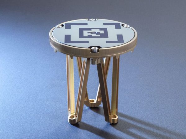
Astroscale of the UK will provide Xona Space Systems with next-generation docking plates for integration into Xona’s growing constellation of low Earth orbit (LEO) satellites. The collaboration supports two critical goals: building a resilient positioning, navigation and timing (PNT) infrastructure and keeping Earth’s orbit safe and sustainable.
Xona is developing Pulsar, an advanced PNT satellite infrastructure based in LEO. Pulsar operates alongside legacy systems like GPS, delivering stronger signals, centimeter-level precision, and built-in protection against interference including jamming and spoofing. As threats to global navigation escalate, a more resilient and secure PNT architecture has become essential for national security, critical infrastructure and connected devices around the world.
“Resilient PNT is a national and economic priority,” said Giorgio Taylor, Director of Business Development, Xona UK & Europe. “Pulsar delivers stronger, faster, and more secure navigational intelligence designed for the threats we face today. Our work with Astroscale reinforces our belief that space infrastructure should evolve to continue meeting user needs, not remain frozen in time.”
Astroscale will provide docking plates for Xona’s future Pulsar satellites as the company scales to launch its full constellation, allowing for future in-orbit servicing, upgrades or safe deorbiting. This supports a more flexible and responsive satellite architecture and helps prevent space debris. These are both key parts of responsible space operations.
An exclusive interview with Julian Thomas, managing director, Racelogic. For more exclusive interviews from this cover story, click here.
In which markets and/or applications do you specialize?
We originally designed our LabSat simulator for ourselves, because we supply GPS equipment to the automotive market. Then, we decided to sell it into that market, which is our primary market, for other people to use. That’s where we started, but it has moved on since then. We supply many of the automotive companies who use it for testing their in-car GPS-based navigation systems.
However, we’ve moved on to our second biggest market, which is the companies that make deployment systems for internet satellites, which use it for end-of-life testing. Several of our customers use it. That’s because we do space simulations, so we can simulate the orbits of satellites. That’s very useful when they’re developing their satellites.
We supply many of the major GPS board manufacturers — such as NovAtel, Garmin, and Trimble — when they’re developing their boards and testing their devices. We supply many of the phone companies — such as Apple and Samsung — and many of the GPS chip manufacturers — such as Qualcomm, Broadcom, and Unicom. More or less any company that’s into GNSS.
How has the need for simulation changed in the past five years, with the completion of the BeiDou and Galileo GNSS constellations, the rise in jamming and spoofing threats, the sharp increase in corrections services, and the advent of new LEO-based PNT services?
It all started off very simple, with just GPS, which was one signal and one frequency. We got that up and working very well and it helped us a lot. Then we got into this market. In the last few years, we’ve had to suddenly invent 15 new signals. We do two systems, really: one is a record-and-replay system. You put a box in a car, on a bike, in a backpack, or on a rocket, and you record the raw GPS signals; then you can replay those on the bench. That requires greater bandwidth, greater bit depth, smaller size, battery power, all of that.
The other is pure signal simulation. We simulate the signals coming from the satellites from pure principles. So, we’ve had to dive into how those signals are structured, reproduce them mathematically, and then incorporate that in into our software. That’s been 15 times the original work we thought it would be, but as we add each signal it tends to get a bit simpler until they add new ways to encode signals, and then it gets complex again. We’ve had to increase our bandwidth, increase our bit depth for the recording to cover all of these new signals.
Because our systems record and replay, they’re used a lot to record real-world jamming. In many scenarios, our customers will take one of our boxes into the field and record either deliberate jamming or jamming that’s been carried out by a third party. Then they can replay that in the comfort of their lab.
With regards to spoofing, we’ve just improved our signal simulation. So, we can completely synchronize it with real time. We can do seamless takeover of a GNSS signal in real time. We can reproduce the current ephemeris and almanac. If we transmit a sufficiently powerful signal, we can completely take over that device. Then we can insert a new trajectory into it. That’s a very recent update we’ve done.
If the complexity and amount of your work has gone up so much in the last few years but you cannot increase your prices at the same rate, what does that do to your business model?
It’s the same people that produce the signals in the first place, so they still have a job. However, as we add more signals and capabilities, we tend to get more customers as well.
Oh, so, you’re expanding your market!
Right, right.
Regarding some of the new PNT services being developed, how do you simulate them realistically without the benefit of recordings of live sky signals?
It is all pure signals simulation. You go through the ICD line-by-line and work out the new schemes. Here’s an interesting anecdote. Our developer who does a lot of the signal development is Polish and is also fluent in Russian. When we were developing the GLONASS signals, he was working from the English version of the GLONASS ICD. He said that it didn’t make any sense. So, he looked at the Russian version and discovered that the English one had a typo. When he used the Russian version, everything worked perfectly. He told this to his contacts at GLONASS and they thanked him and updated the English translation of their document. So, you are very, very much reliant on every single word in that ICD.
Are there typically differences between the published ICD and the actual signal?
No, no. Apart from the Russian one, which had a typo, they’re very good. For example, we’ve recently implemented the latest GPS L1C signal. My developer spent six months recreating it and getting all the maths right and the only way you could test it was to connect it to a receiver and hit “go.” It just worked the first time. He almost fell off his chair. The ICD in that case was very, very accurate.
Hope that Xona’s ICD is just as good.
Yeah.
Are accuracy requirements for simulation increasing, to enable emerging applications?
Yes, absolutely. No one can have too much accuracy. Everyone’s chasing the goal of getting smaller, faster, and more accurate systems. They want greater precision and better accuracy from their simulators, as well as a faster response. We do real-time simulators and they want a smaller and smaller delay from when you input the trajectory to when you get the output. Luckily for us, Moore’s law is still in effect, so, as the complexity of the signals and the accuracy requirements increase, computers can churn through more data. Luckily, we’re able to keep up on the hardware side as well, because much of our processing is done using software. Some companies do it in hardware and some companies do it in software. We concentrate on the software side of things.
Here’s another interesting anecdote from my Polish guy. He noticed that the latest Intel chips contain an instruction that multiplies and divides at the same time but that it wasn’t available in Windows. So, he put in a request with Microsoft for that operational code and they incorporated it into the very latest version of dotnet, which has improved our simulation time by 7%. I see little improvements like that all the time.
Are all your simulators for use in the lab or are some for use in the field? If the latter, for what applications and how do they differ from the ones in the lab? (Well, for starters, I assume that they are smaller, lighter, and less power-hungry…)
All our systems are designed to be used inside and outside the lab. They can all be carried in a backpack, on a push bike, in a car. We do that deliberately, because we come from the automotive side of things, so we have to keep everything very small and compact.
Besides automotive, what are some field uses?
Some of our customers have put them in rockets, recording the signal as it goes up, or in boats. We have people walking around with an antenna on their wrist connected to one of our systems, so that they can simulate smartwatches. There are many portable applications. We have a very small battery-powered version, which makes it very independent.
Are there any recent success stories that you are at liberty to discuss?
Our most exciting one is a seamless transition for simulation that we developed to replace or augment GPS in tunnels. We’ve been talking to many cities around the world that are building new tunnels. Because modern cars automatically call emergency services when they crash or deploy their airbags, they need to know where they are, of course. Cities need to take this into account when they are building new tunnels, which can pass over each other or match the routes of surface streets. Therefore, accurate 3D positioning in the tunnels has become essential. It requires installing repeaters every 30 meters along each tunnel and software that runs on a server and seamlessly updates your position every 30 meters. As you enter a tunnel, your phone or car navigation system instantly switches to this system. It’s been received very well because it’s mainly software and the hardware is pretty simple. We’ve brought the cost down to a fifth of the cost of standard GPS simulators for tunnels. So, we’re talking to several cities about some very long tunnels, which is very exciting.
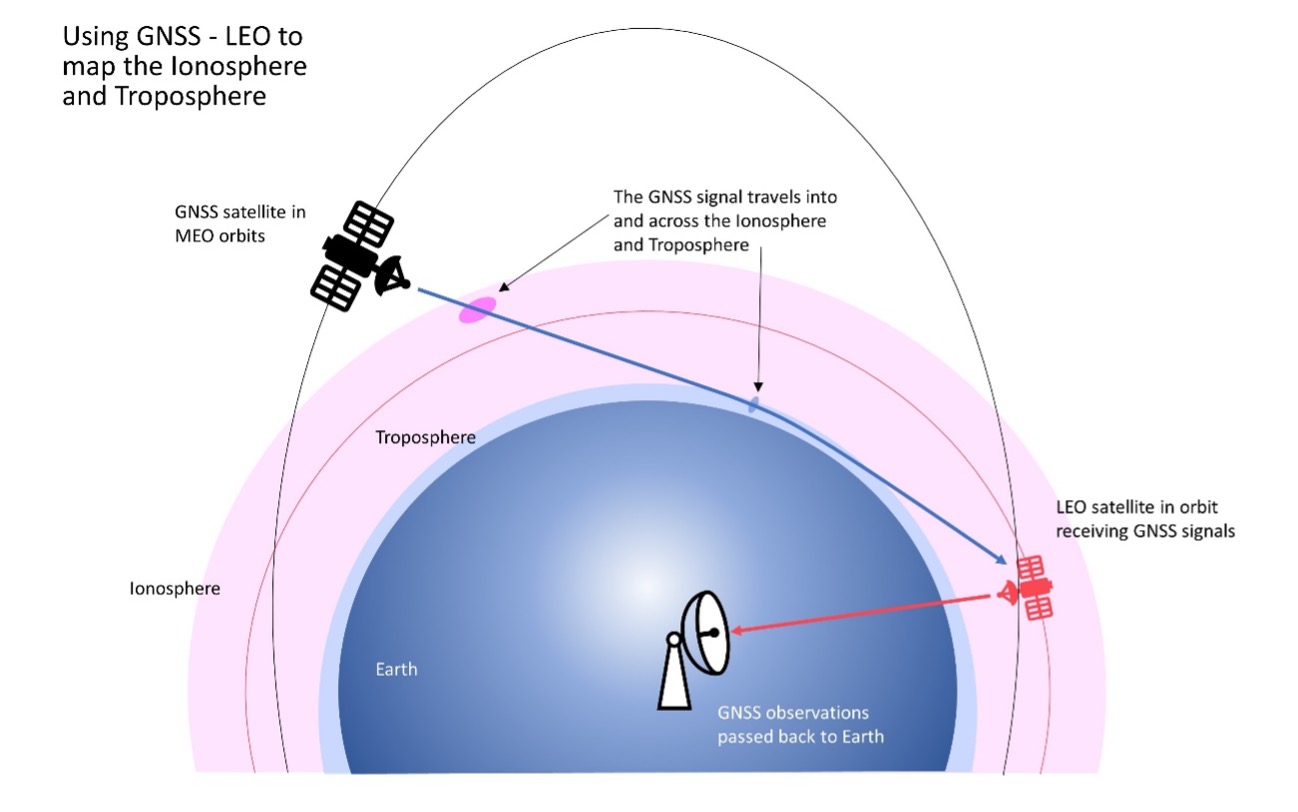
FrontierSI has signed a collaborative agreement with Geoscience Australia, Curtin University and the University of Newcastle to enhance Ginan with features specifically aimed at supporting low-Earth orbit (LEO) satellites as an important component of Geoscience Australia’s Positioning Australia program.
Ginan is Geoscience Australia’s GNSS analysis center software. It delivers a real-time positioning correction service through open-source software and additional positioning products to enable precise point positioning for Australian industry and users.
The design, development and deployment of LEO satellites has grown significantly over the last decade. The agreement with FrontierSI complements ongoing Ginan precise orbit determination (POD) development activities, focusing on the implementation of LEO satellite modeling and the orbit integrator/propagator capabilities needed to enable LEO GNSS data to be processed and high-precision LEO satellite trajectories estimated and predicted.
Such a capability will enable:
better monitoring of LEO satellites for station keeping, collision avoidance and end-of-life purposes
improved ionosphere and troposphere monitoring and modeling through the analysis of GNSS signal occultation, to provide data for weather prediction and precise positioning purposes.
Celestia UK has won a €800,000 European Space Agency (ESA) contract to develop an innovative positioning, navigation and timing(PNT) solution based on LEO satellite constellations for 5G networks and applications.
The contract was granted under ESA’s Navigation, Innovation and Support Programme (NAVISP).
Malachy Devlin, CEO, Celestia UK
Celestia’s LEO-SYN+ project is intended to boost the reliability and performance of GNSS. It will use low-Earth-orbit (LEO) satellite signals of opportunity to provide a resilient position and time reference for 5G networks and improve the robustness of GNSS signals.
It includes development of a PNT receiver compatible with multi-GNSS constellations and LEO signals of opportunity, as well as testing of the solution in 5G networks. A prototype receiver will validate the product design and the technology development, paving the way for additional applications of the technology to other critical infrastructures after the initial ESA NAVSIP roll-out.
To deliver the ambitious project, Celestia UK is partnering with Heriot-Watt University, which brings extensive knowledge in satellite communications and digital signal processing, and The Scotland 5G Centre, the national center for accelerating deployment and adoption of 5G and realizing its economic and societal potential for Scotland.
“It is a great benefit for the business to have won an ESA NAVSIP contract,” said Malachy Devlin, CEO of Celestia UK. “We are looking forward to collaborating with ESA and our partners to unlock the potential to improve the resilience of 5G networks with our PNT solution.”
Ian Sharp, head of Business Development, The Scotland 5G Centre, added,“The Scotland 5G Centre is providing businesses access to 5G services through a national network of innovation hubs, under its 5GConnect Programme. It is well known that 5G will support higher data throughput and interactive services through reduced latency. However, 5G will also provide new possibilities for positioning, navigation and timing (PNT). Use of advanced antennas and positioning over satellite will be critical for outdoor applications where precise navigation is essential to meet safety requirements for the likes of drone navigation and autonomous vehicles. We are delighted to be working alongside Celestia UK, supporting the innovative LEO-SYN+ project, which will utilise our cutting edge 5G network.”
Other sources, such as lidar, can be used to aid navigation in the absence of GNSS signals. (Photo: OxTS)
We discussed complementary PNT with Peter Rylands, senior product manager at OxTS.
What are some of the most promising approaches to complementary PNT and how does simulation technology help?
There are two approaches of particular interest. The first is looking at LEO satellite systems that can provide supplementary and potentially more secure methods of navigation, with global coverage from a single system. But these will still suffer from some of the issues GNSS systems experience, namely, what happens when you can’t obtain a signal?
The second is the use of visual aiding through sensor fusion, such as lidar and cameras, that can provide relative positioning (or absolute positioning once you have a space mapped) using SLAM algorithms. While this may increase onboard hardware dependencies, it creates a localized navigation system that can be better protected from malicious actors.
In contrast, closed-loop systems can look to an infrastructure-based system, allowing free movement within the specific area in which the infrastructure is located and a potentially more reliable source of PNT, especially indoors, where GNSS is not available. Ultra-wideband is definitely the up-and-coming technology here, but systems using Wi-Fi, cameras, Bluetooth and others also are being used.
Simulation, as within many domains, allows users to test on a large scale with fewer barriers to entry than real-world testing and an ease in making iterative changes to find an optimal solution. Whether that is to benchmark performance in locations of interest or to change configuration settings to improve visibility or positioning, simulation allows you to do this without the expense of going straight into the environment itself or configuring the actual vehicle under test.
How does OxTS fit in that mix?
OxTS provides customers with the ability to navigate anywhere; whether for reference data in R&D, georeferencing for survey and mapping, or active navigation of autonomous solutions. To do this we provide an IMU-first offering that we then complement with other technologies. Traditionally, this is with GNSS, to form an INS that can provide centimeter-level accuracy. However, we are also aware of the vulnerabilities of GNSS. For us, this is when it becomes an unreliable source of PNT in denied areas, such as indoors, in urban canyons or under tree canopies.
Because of this, we are also investigating and developing complementary solutions that can enhance our offering for users who need confidence in their position even when GNSS is not available. Whether that is through sensor fusion, our Pozyx UWB solution for indoor navigation or other proprietary software and firmware capabilities.
What kinds of complementary PNT are most useful in addressing specifically the challenges posed by jamming and spoofing and how does simulation help?
We need to look at systems that cannot be impacted by, or have mitigations from, the impact of jamming and spoofing. Solutions that are independent of radio communications or satellite use are then valuable in providing this layer of protection. This is where we could look toward OxTS’s use of IMU technology and visual aiding systems. Simulation technologies would then allow you to run hardware-in-the-loop testing, where the primary GNSS solution can have simulated jamming and spoofing to understand the performance of your complementary and protected systems when GNSS cannot be trusted.
Jackson Labs Technologies PNT-6200 Series, an STL-based time and frequency reference system installed in a 5G application. Photo: Satelles
We discussed Satellite Time and Location (STL) services and complementary PNT with Michael O’Connor, CEO at Satelles.
What is the problem with GPS/GNSS that Satelles aims to solve?
GPS and GNSS are amazing. We designed Satellite Time and Location (STL), the service that we offer, to complement those capabilities. We have focused on three unique aspects in the areas where GPS could use complementary service. First, we provide a fully independent backup. We all know that things can happen, so we aim to provide an independent source of position navigation, and timing (PNT). Second, we focused the high-power aspect of STL to enable us to reach indoors and other places where GPS does not reach. Because STL comes from low Earth orbit (LEO) satellites, the signals are naturally at a higher power.
We also focused on improving the indoor penetration capability by enhancing the signal design and doing some other things. Third, we use modern cryptographic techniques to ensure the security and resilience of the system, specifically to intentional misdirection attacks. If you can ensure that the signal is coming from the satellite and not from a third party you can have a more secure and resilient solution.
To what extent can you replace GPS during an extended outage?
We have never considered LEO PNT as a replacement for MEO (medium Earth orbit) GNSS. GNSS are the primary domain of PNT but there are applications that have additional needs. The more independence you can get, the fewer the common modes of failure, if you can at least have some survivability in the absence of GNSS. That’s one of the services we can offer. It is probably not the most important thing to our customers, honestly. The service we offer is similar to GPS and GNSS in that we have a space segment (the satellites), a ground segment, and a user segment. We have space vehicles, user equipment, and ground infrastructure that supports the space infrastructure.
What’s interesting about the way we work with the Iridium satellite constellation is that the satellites themselves include inter-satellite links. That provides a lot of resilience to ground-based events. The satellites themselves have a time transfer capability between them. So, we don’t require a direct connection to every satellite to propagate a time throughout the network. That’s one unique aspect we can take advantage of with this particular network, Iridium, which is pretty amazing.
Additionally, we have multiple ground infrastructure and monitoring sites and multiple sources of time at those ground monitoring and control stations. For example, some of them rely on GNSS combined with atomic clocks as their master timing source but we also have one installed at the National Institute of Standards and Technology facility in Boulder, Colorado. So, we have multiple primary time sources that we can integrate into our filtering across the network. That, combined, with satellite links, allows us to maintain time for substantial periods independent of GNSS.
How do you define “complementary PNT” and how does Satelles fit in that mix?
Several applications have additional needs beyond what GNSS offer. There are many technologies that can come to bear on that. There’s the LEO satellite base, which is where Satelles fits in, but there are also local and wide-area terrestrial radio navigation sources, network-based time transfer, signals of opportunity, and so on. They all have something important to offer, depending on the application. Satelles’ LEO satellite solution is available today, has global coverage, and is relatively affordable. It leverages the capital investments that have been made to launch the satellites to provide this service globally. The industry is working together to make sure that an awareness of these capabilities is propagated throughout the industries that we serve.
Besides the orbit height, which requires many more satellites, how does your system differ from GNSS?
We do not consider LEO PNT as something that might replace MEO PNT. The fundamental difference is being in lower Earth orbit, which results in a higher received power. That is what allows us to penetrate, just based on the 1/r2 losses. The measurable Doppler signatures give additional observables for PNT calculations, and higher satellite dynamics that can help with multipath. This service relies on many of the same physics and geometry as GPS. We measure the time of arrival of a very similar signal. The signals from the Iridium satellites are even in the L band. Very often we’re using a GPS chip that’s been reprogrammed to track and utilize our service as well as GPS or instead of GPS.
If I explained how GPS works to, say, a high school science class, how much of that basic explanation—about trilateration, spread spectrum, etc.—would also apply to your system?
It’s fundamentally the same. It relies on a lot of the same physics and geometry. We measure the time of arrival of a very similar signal. The signals from the Iridium satellites are even in the L band. Very often we’re using a GPS chip that’s been reprogrammed to track and utilize our service as well as GPS or instead of GPS. There are subtle differences—for example, a lower Earth orbit is faster—but it is very similar.
How would GPS user equipment have to be modified to make use of your service?
We don’t think of STL as something where we are modifying GPS user equipment. Rather, we think about what must be done in an end-user application to meet their needs. For example, one of our partners, Orolia, has a GNSS + STL secure synchronization product that we have delivered to customers in data centers and major stock exchanges around the world. Those are operational and in service. They integrate through standard interfaces, such as PPS or PTP, depending on the type of equipment to which they are connecting.
Ultimately, we don’t think of it is as replacing GPS user equipment. Rather, where a user has a need for PNT, they’re opting for this GNSS + STL solution because they have an indoor need, such as a data center, or they have a need for resilience in the case of a stock exchange.
Another example is Jackson Labs. The Jackson Labs 2600 is also a GNSS + STL solution that generally is integrating with existing 5g. It has a specialized transcoder interface that can work with any existing GNSS-type equipment. In some cases, we’ve taken a chip that was originally designed for GPS and modified its firmware.
Who are the earliest adopters?
Satelles’ LEO satellite solution is available today, has global coverage, and is relatively affordable. It leverages the capital investments that have been made to launch the satellites to provide this service globally. Data centers, stock exchanges and cell phone providers are implementing these capabilities today. The major wireless operators are seeing that more and more of the 5G infrastructure they roll out is going indoors, where GPS doesn’t reach. We provide a solution that integrates with their existing solutions and can provide reliable timing capabilities.
If your solution can survive on its own, why does it need GNSS at all?
In some cases, the user is not using GNSS at all. The product itself has a GNSS capability. User equipment is very affordable and the service is taxpayer-funded. In many cases, especially for indoor installations, the equipment that is installed is capable of tracking GNSS and STL signals, but often it relies on the STL signal itself for timing.
How do you predict STL spreading through various applications and industries?
We have our hands full with the markets we’re going after now, but there are certainly going to be other markets in which the customers will recognize that they have a critical need to implement a backup solution.
In the long run, could LEO satellites replace MEO ones for GNSS?
Sometimes there have been misperceptions in the industry. I’ve never considered that LEO PNT satellites might replace MEO ones. There are excellent reasons why Brad Parkinson, Jim Spilker, Gaylord Green and others decided almost 50 years ago to put GPS in MEO. Those physics haven’t changed. You can cover a large portion of Earth with each satellite. LEO will not replace MEO, but it has unique characteristics that make it a great complement to the GNSS MEO solutions.
Do you have any additional comments about complementary PNT?
It’s good to see that the federal government is encouraging the adoption of complementary PNT, which they often call “GPS backup.” It is encouraging to see the amount of activity on this issue that’s been going in Washington over the last couple of years. Although our company is very focused on delivering a LEO-based PNT service, which has several advantages for customers that need a global capability, many technologies can play an important role in those solutions.
The U.S. Department of Transportation did a fantastic job of looking at several of those technologies across those different categories. The European Union has also had a similar activity recently. Some reports will be coming out soon about that. It is very important that the government understands that this is an important issue for our society and encourages industry to adopt these solutions and is even starting to make some investments toward that. That includes executive order 13905 and some recent funding increases by Congress.
All of that has been very important and positive, as has modifying some of the legislation to be more inclusive of multiple technologies, such as removing the words “land-based” from the National Timing, Resilience, and Security Act this year.
I am involved in an industry consortium, the Open PNT Industry Alliance, with several other companies whose CEOs are in alignment that there is no single answer. Having a thriving ecosystem of technologies and companies trying to solve this important problem is incredibly important and it’s exciting to see.
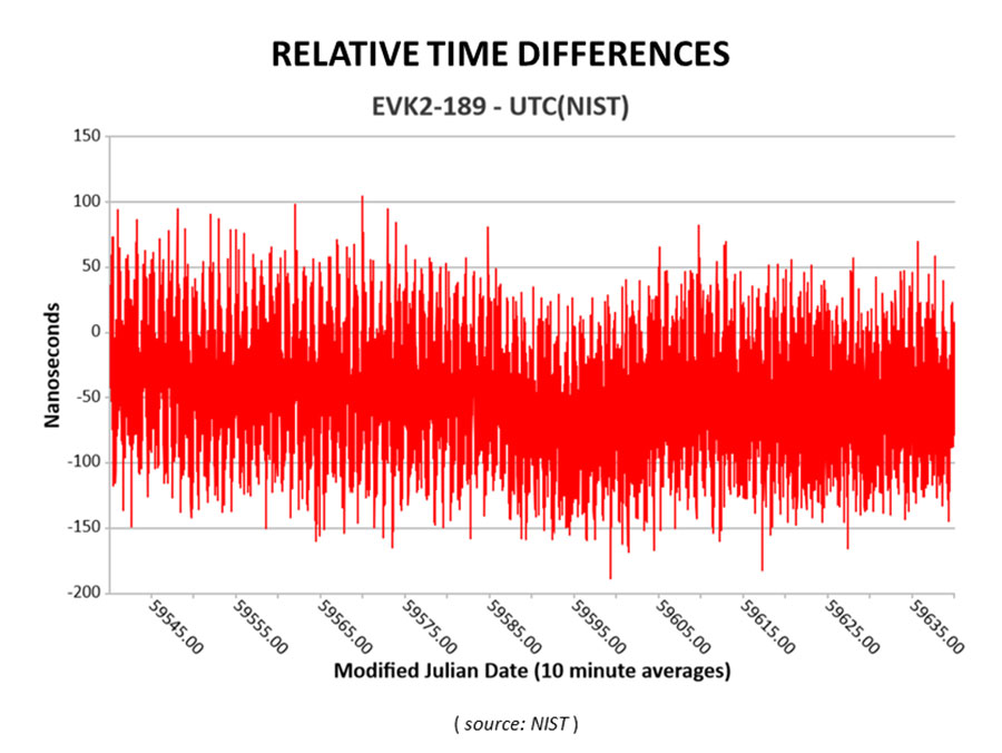
Cooperative agreement expands precision timing distribution options for critical infrastructure and verifies STL’s agreement with UTC via UTC(NIST)
This March 30, 2022, chart of Satelles and NIST testing verifies that STL timing agrees with UTC. (Chart: Satelles)
Satelles Inc., provider of highly secure satellite-based time and location services, has entered a cooperative agreement with the U.S. National Institute of Standards and Technology that directly connects STL’s operational infrastructure to the source of UTC(NIST), the national standard for time and frequency in the United States produced in coordination with the U.S. Naval Observatory.
The agreement calls for Satelles to provide its STL service to NIST. Reciprocally, the agreement includes the introduction of a connection between an STL Ground Monitoring Station (GMS) provided by Satelles to the NIST collection of extremely accurate atomic clocks that maintains the official time scale for UTC(NIST).
The Cooperative Agreement was described in NIST Technical Note 2187, “A Resilient Architecture for the Realization and Distribution of Coordinated Universal Time to Critical Infrastructure Systems in the United States,” published in November 2021.
In February 2021, Satelles delivered and configured an STL GMS at NIST’s Time and Frequency Division in Boulder, Colorado. This facility is home to the ensemble of high-precision cesium beam and hydrogen maser atomic clocks that maintains UTC(NIST).
After conducting a series of successful preliminary tests in the spring of 2021, NIST then directly connected the STL GMS to its primary clock ensemble in June 2021. Comparing timing provided by STL to UTC(NIST), the testing confirmed STL’s long-term stability of better than 25 nanoseconds with short-term time deviation of 50 nanoseconds.
STL from Satelles is a resilient, alternative PNT service from low-Earth-orbit (LEO) satellites that enterprise customers rely on as a primary timing source. Telecom operators, for example, use STL for 5G wireless network deployments where GPS is unavailable indoors or when other timing solutions cannot provide the required level of accuracy.
STL’s agreement with UTC also is important for critical infrastructure and other applications that require an essential contingency capability to protect the operations of PNT-dependent systems and ensure survivability and resilience.
“Satelles has a network of GMS nodes positioned around the world to receive STL signals and calculate the position and timing of the satellites for purposes of producing timing corrections, and
now we are fortunate to have a GMS connected inside NIST’s main time lab,” said Gregory Gutt, president and CTO of Satelles. “It’s an honor to be given direct access to UTC(NIST), especially in an arrangement that delivers benefit to both our customers and NIST.”
Visit satelles.com/nist for more information about NIST reports that detail the performance of STL and collaborations between Satelles and NIST.
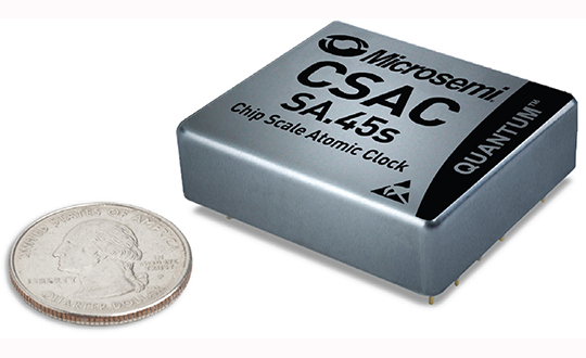
The device provides the accuracy and stability of atomic clock technology while achieving significant breakthroughs in reduced size, weight and power (SWaP) consumption, the company said.
As the newest member of Microsemi’s CSAC product family, the Commercial Space CSAC provides excellent drift performance and built-in 1 pulse per second (PPS) input for GPS disciplining, making the device well-suited for holdover applications.
It is targeted at several other commercial space and space research applications, including:
satellite timing and frequency control;
satellite cross linking;
assured position, navigation and timing; and
Earth observation.
With many spacecraft manufacturers turning to commercial off-the-shelf (COTS) parts to meet performance, schedule and cost requirements, the Commercial Space CSAC offers a solution for many satellite missions.
“With the introduction of the Commercial Space CSAC, we now offer a space-deployable atomic precision clock reference with radiation tolerance in support of the space market’s desire to reduce mission costs and design times using COTS devices,” said Peter Cash, director of the clock business unit at Microsemi. “As the first atomic reference clock with low SWaP available for space, our new device is well-suited to applications requiring precise clock synchronization, including a variety of existing and emerging LEO applications.”
According to a market intelligence report by Euroconsult titled, “Satellites to be Built & Launched by 2026 World Market Survey,” the total revenue for satellite manufacture and launch is expected to be $304 billion between 2017-2026. With revenues of $102 billion, LEO is expected to account for a third of the total market, with 82 percent derived from satellite manufacturing.
“Harris provides the world’s most advanced sensors, payloads and communications technologies; receiving and information processing systems; and analytics, which provide our customers with the integrated information and actionable intelligence they need for mission and business success,” said Tim Lynch, general manager, Mission Solutions at Harris Corporation’s Space and Intelligence Systems segment. “Microsemi’s latest atomic clock will support Harris in delivering complete mission solutions to our customers.”
As a stand-alone atomic clock with a 10-megahertz CMOS-compatible output, Microsemi’s Commercial Space CSAC is a timing module providing an impressive short-term stability (Allan Deviation) and frequency stability across the operating temperature (TempCo), the company added.
A standard CMOS-level RS-232 serial interface is built into the device, which is used to control and calibrate the unit and provide a comprehensive set of status monitors. The interface is also used to set and read the CSAC’s precise internal time-of-day clock.
Microsemi’s radiation-tolerant ruggedized oscillators also include OCXOs and EMXOs for applications that require higher accuracy and can support higher power consumption.
Other key features include:
Power consumption of less than 120 milliwatts (mW)
Less than 17 cubic centimeters volume (1.6 in. × 1.39 in. × 0.45 in.)
Radiation-tolerant: 20 krad
Single event latch-up (SEL) and single event upset (SEU) tested to 64 megaelectron-volts per square centimeter/milligram (Mev-cm2/mg)
Short-term stability (Allan Deviation) of 3.0 × 10⁻¹⁰ at TAU = 1 sec
Frequency stability across temperature range (TempCo) less than 5×10⁻¹⁰
1PPS output and 1PPS input for synchronization and time-keeping
The main objective of this work is to investigation the feasibility and performances of LEO communication satellite constellations as potential navigation augmentation platforms. The further examination of the existing and upcoming LEO communication satellite constellations has been conducted, such as Iridium, Globalstar, Teledesic, One Web, Boeing, SpaceX, Samsung, etc. The comprehensive performances of LEOs for navigation augmentation are evaluated and analyzed in terms of constellation characteristics, footprint, coverage, signal strength, dilution of precision (DOP, including GDOP, PDOP, VDOP, HDOP), and number of in-view satellites, with comparison of these to the current GPS, Galileo and BeiDou systems. The results showed that LEOs present superior performances compared with GNSS systems, and demonstrate promises as navigation augmentation platforms for challenging environments.
Moreover, the real-time signal-aided navigation method is explored, from user geometry and signal ranging errors to position errors. Then, we proposed a navigation system based on signals of opportunity from LEO platform. The proposed system relay on a terrestrial benchmark network consists of several monitoring stations with time synchronization. It would acquire the downlink communication signal from LEO platforms, and then estimate the time difference of arrival (TDOA) between stations with a correlation-based blind detection algorithm. The TDOA estimations and geographical position information are utilized to develop the time-delay-based spatio-temporal distribution model, which can determine the user’s position by matching the model with its estimated TDOA values. The proposed navigation system can operate stand-alone and facilitates the integration of communication and navigation system.
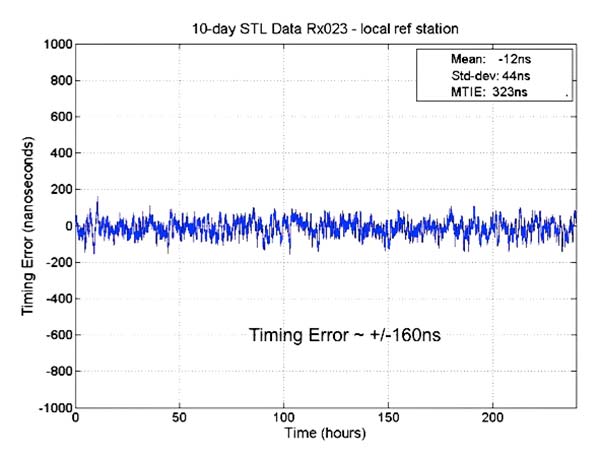
Results from new tests of the Satellite Time and Location (STL) service, using equipment configurations with a differential source and with a more accurate OCXO clock, show timing accuracy of 160 nanoseconds.
The STL service uses a signal from the low-Earth orbit (LEO) Iridium constellation.
In 2016, Satelles demonstrated sub-microsecond timing using a stand-alone TCXO-based receiver (see “Innovation: Navigation from LEO,” July 2017 GPS World).
New testing employed three different configurations of equipment, services and environment, including a Stanford Research Systems (SRS) rubidium vapor frequency reference, based on the PRS10 module, and a Satelles Evaluation Kit (EVK2) STL receiver, comprising a Maxim RF chip, Xylinx Spartan-3 FPGA, TI dual-core DSP chip, and internal OCXO (oven-controlled crystal oscillator) or external clock.
Parameters and equipment for the three tests are:
Optimal. Outdoor antenna, Rubidium clock powered on for months prior to data collection, receiver configured in static mode with a known location, and high-quality antenna.
Sub-optimal. Indoor antenna, Rubidium clock powered on six hours prior to data collection, receiver configured in static mode with an unknown location, and low-quality antenna.
Three independent receivers collecting data, receiver on-board OCXO, indoor antenna, receiver configured in static mode with an unknown location, low-quality antenna. Tests performed: 10 days with no local reference station running; 10 days with local reference station, 20-kilometers away from test receivers, providing timing corrections to STL ground segment.
See Figure 1 for more extensive test results. Also see a previous article.
FIGURE 1. OCXO timing result with base station.
The 66-satellite Iridium LEO constellation transmits overlapping spot beams, which provide location-specific data that changes every few seconds.
Air Force Issues GPS III Follow-on Contract
The U.S. Air Force Space Command released its request for proposals to build 22 new GPS III satellites, called the GPS III Follow-On Phase 2 contract.
The contract will be awarded to a single bidder, and has an estimated dollar value of $10 billion including all options.
Phase 2 is planned as a single, predominantly fixed-price incentive-type contract awarded via full and open competition for production of 22 GPS III satellites. Deadline for proposals is April 16. Delivery of the first satellite is to be in 2026.
Phase 1 contracts awarded in May 2016 to Boeing, Northrop Grumman and Lockheed Martin (builder of the first 10 GPS III satellites) “determined that viable, low-risk, high-confidence sources exist to conduct a full and open competition for Phase 2, the production of 22 GPS III SVs [space vehicles] starting in the FY19 timeframe.”
BeiDou’s Long March
On Feb. 12, BeiDou-3 28 and 29 were launched into medium-Earth orbits, following the launch of a pair of BeiDou satellites on Jan. 11. The satellites form part of a third phase of BeiDou deployment, taking BeiDou coverage from regional to covering the countries along the Belt and Road initiative by the end of 2018, and global by 2020.
Editor’s Note: This online preview presents brief highlights from the upcoming July cover story in GPS World, “Navigation from LEO: Current Capability and Future Promise.” The article is by David Lawrence, H. Stewart Cobb, Greg Gutt, and Michael O’Connor of Satelles, Tyler G. R. Reid and Todd F. Walter of Stanford University, and David Whelan.
Robust position, navigation, and timing services from low Earth orbit (LEO) are here today, providing augmentation to GPS where GPS isn’t available. The addition of navigation signals from LEO provides a number of benefits. The proximity of LEO satellites has the potential to provide much stronger signals than the distant GNSS core-constellations like GPS in medium-Earth orbit (MEO).
Today, the only LEO system with global coverage is the Iridium constellation used primarily for communications.
Figure 1 shows the 31-satellite GPS constellation in contrast with the 66-satellite Iridium network. The scale of the difference in distance (several Earth radii) is extraordinary. The result is that Iridium signals are 300 to 2400 times stronger than GNSS signals on the ground, making them attractive for use in position, navigation, and timing (PNT) applications where GNSS signals are obstructed.
Figure 1. The 66 satellite Iridium constellation in low Earth orbit and 31 satellite GPS constellation in medium Earth orbit.
LEO-based PNT is now mainstream, in the form of real-time signals that have been delivered over the Iridium satellite network since May 2016. This service is made possible by Satelles in partnership with Iridium Communications Inc. in a service called the Satellite Time and Location (STL), a non-GNSS solution for assured time and location that is highly resilient and physically secure. Consumers, businesses, and governments are already using these LEO-based signals in environments with high GNSS interference or occlusion.
The security features of these signals are also used to reliably validate GNSS position, navigation and time (PNT) solutions in real time to help mitigate potential spoofing. Furthermore, the fast LEO orbits of Iridium generate Doppler-frequency signatures significantly stronger than GPS, increasing the utility of the STL signal for positioning applications.
STL field tests demonstrate a positioning accuracy of 20 meters and timekeeping to within 1 microsecond, all in deep attenuation environments indoors. This adds substantial robustness in augmenting the GNSS core-constellations like GPS and also allows for a standalone backup in many applications.
Along with its strong signals compared to the GNSS core-constellations in MEO, Iridium’s global coverage makes it ideal for use in PNT applications where GNSS is obstructed. Figure 1 shows the scale of the difference in altitude with Iridium at 780 kilometers and GPS at 20,200 kilometers. This has substantial implications not only for signal strength but also for coverage.
Though Iridium has twice as many satellites as GPS, at the equator users can often only see one satellite whereas they can see ten from GPS. This was one of the fundamental trades considered in the design of the GPS constellation. The higher the altitude, the more each launch cost; the lower, the more satellites had to be built to provide coverage. To put this in perspective, global coverage for one satellite in view at all times requires fewer than ten satellites in MEO but requires closer to one hundred in LEO.
Future LEO Constellations
The hundreds of LEO satellites needed to match the coverage of GPS may be coming. In late 2014 and early 2015, the International Telecommunication Union (ITU) reported a half dozen filings for spectrum allocation for large constellations of LEO satellites.
In January 2015, OneWeb announced a partnership with Virgin and Qualcomm to produce a constellation of 648 LEO satellites to deliver broadband Internet globally. This represents the next order of magnitude, with tenfold more satellites than Iridium. Within days of this announcement, SpaceX, with support from Google, announced a similar ambition for a constellation of more than 4,000 LEO satellites.
In August 2015, Samsung expressed interest in a proposal for a LEO constellation of 4,600. Boeing joined the race in June 2016 announcing plans for a LEO constellation of nearly 3,000 satellites. These LEO constellations are being proposed to keep up with the rising demand for broadband, not to replace ground infrastructure.
LEO versus MEO
Low- and medium-Earth orbit each have their individual strengths and weaknesses in the context of navigation. Closer to Earth, LEO offers less spreading loss and improved signal strength on the ground. On the other hand, being closer to Earth means that satellites have much smaller footprints. The GPS footprint is threefold larger than Iridium, corresponding to nine times more area covered. Hence, to achieve the same coverage as GPS with Iridium’s altitude, the LEO constellation requires an order of magnitude more satellites.
Another major difference between LEO and MEO is speed. A GPS satellite completes one Earth revolution every 12 hours while an Iridium one does so in only 100 minutes. The shorter the orbital period, the faster the angular rate (also called mean motion) and the more quickly satellites pass overhead.
The swift motion whitens multipath (making it more random–like white noise) as reflections are no longer effectively static over short averaging times. Geometric diversity also leads to effective Doppler positioning and is also desirable for carrier-phase differential GNSS, allowing for much more rapid resolution of integer cycle ambiguities.
Iridium-Satelles Satellite Time and Location (STL)
The STL service has been in operation since May 2016. Many from industry and government are already using this service to achieve a more robust PNT solution. This service will only continue to improve with the Iridium NEXT satellites under deployment; the first ten satellites of this generation were successfully launched in January 2017.
STL is a non-GNSS solution for assured time and location that is highly resilient and physically secure. STL utilizes the Iridium constellation to transmit specially structured time and location broadcasts. Due to their high RF power and signal-coding gain, the STL broadcasts are able to penetrate into difficult attenuation environments, including deep indoors.
Like GNSS signals, these broadcasts are specifically designed to allow an STL receiver to obtain precise time and frequency measurements to derive its PNT solutions. STL is able to augment or serve as a backup to existing GNSS PNT solutions by providing secure measurements in the presence of high attenuation (deep indoors), active jamming, and/or malicious spoofing.
Unlike the MEO GNSS satellites, Iridium uses 48 spot beams to focus its transmissions on a relatively small geographic area. The complex overlapping spot beams of Iridium combined with randomized broadcasts give a unique mechanism to provide location-based authentication that is extremely difficult to spoof.
The July cover story in GPS World magazine will explore all the above topics in more technical detail, and go further into the areas of signal strength in challenging environments, indoor time-transfer capability, and a section on looking forward.
The PNT service using Iridium is perhaps a sign of things to come. On the horizon are constellations like OneWeb which promise the next order of magnitude with 648+ satellites, slated for the 2020s. This most recent scale gives rise to better satellite geometry than GPS today with the added benefits of LEO.
The STL signal using Iridium sets a precedent that could lead to unparalleled navigation services that are robust due to the improved signal strength and precise due to the huge number of LEO satellites coming, each moving quickly and giving the geometric diversity needed to enable fast carrier-phase differential GNSS.
The need for such a service is already present. This would be enabling for the safety-critical autonomous vehicles under development that must operate in challenging urban environments and to a diversity of other future technologies and applications as well.