Tag: lidar

  • Blue Marble Offers Lidar Module Upgrade

    Blue Marble’s Global Mapper V17‘s Lidar Module is an optional enhancement to its software that provides advanced lidar processing tools, including automatic point-cloud classification, feature extraction, cross-sectional viewing and editing, faster surface generation, and more. It is designed for anyone using or managing terrestrial or airborne lidar as well as other point cloud datasets.

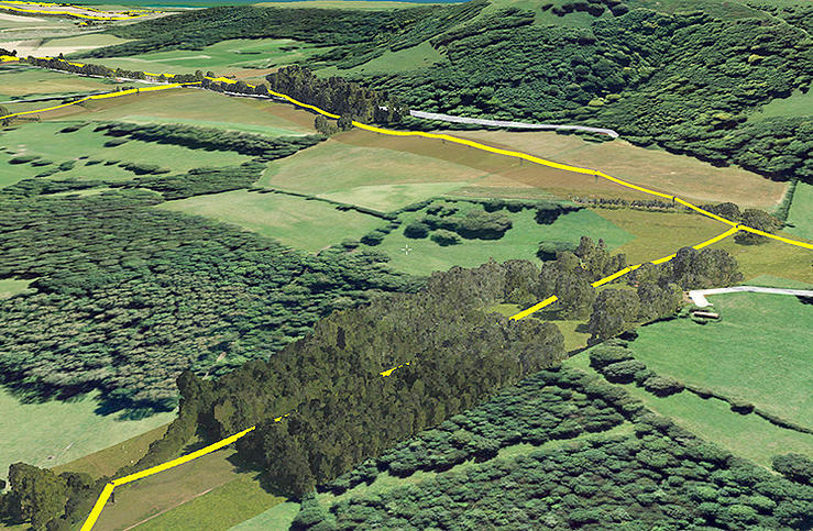
    The Lidar Module was first released with Global Mapper V15, and a host of new lidar tools have since been added. Building on the existing functionality for identifying ground, building and vegetation points in an unclassified point cloud, the latest release of the module includes a powerful new tool for detecting and automatically reclassifying above-ground utility lines.

    After customizing the reclassification parameters, such as minimum height above ground and linear offset threshold, the points representing power lines are automatically attributed with the Wire – Conductor ASPRS lidar class. Analysis of linear patterns in these reclassified points can subsequently be used to create 3D vector lines.

    Addressing a major concern among lidar users, the latest release of the Global Mapper Lidar Module provides an efficient and effective way to remove noise from point cloud data. This powerful filtering tool can reclassify or automatically delete any points that are beyond a prescribed elevation or height above ground threshold within a local area.

    Other enhancements to the module include dramatically faster data rendering and processing as well as updated filtering tools for selecting and, if necessary, removing points based on class, return intensity, color range, and many other parameters.

    Additional functionality offered in the Lidar Module includes:

    • A convenient Lidar Toolbar for easy access to key editing and analysis functions
    • Multiple gridding options for faster DSM or DTM generation
    • Access to point cloud files containing a billion points or more
    • Automatic point classification tools that automatically distinguish building, ground, vegetation and power lines and above-ground utility cables in unclassified layers
    • Feature extraction functionality to automatically create 3D building footprints, trees and power lines
    • Cross-sectional rendering using Global Mapper’s Path Profile tool for viewing and editing the point cloud in a vertical perspective
    • Advanced filtering options to efficiently remove erroneous or unneeded points
    • Detect and reclassify or delete noise points
    • Lidar scripting commands for streamlining workflow
    • Point colorization from underlying imagery offering photo-realistic point cloud rendering in Global Mapper’s 3D Viewer
    • Support for reporting lidar statistics
    • Support for importing and exporting most common lidar formats
    • Support for NIR (near-infrared) data


  • Bluesky Completes Aerial Mapping Project for UK Utilities

    Bluesky Completes Aerial Mapping Project for UK Utilities

    Photo: Bluesky

    Bluesky has completed a multi-million pound aerial mapping project to assess the impact of vegetation on the electricity network of East Anglia and the South East of England. Working on behalf of UK Power Networks, Bluesky undertook the largest ever combined laser mapping and aerial photography survey commissioned by an electricity distribution network operator in the UK — some 34,000 square kilometers.

    The laser mapped (LiDAR) data and aerial photographs were then analyzed to assess the proximity of vegetation to the overhead power lines in order to create a proactive three-year vegetation management program. Bluesky worked in partnership with ADAS, an agricultural and environmental consultancy, to complete the project.

    Dedicated survey planes equipped with a lidar mapping system and aerial survey equipment flew the whole of the South East and East of England. Capturing millions of individual laser mapped height measurements and approximately 310,000 aerial images in just over three months, Bluesky successfully completed the unprecedented data capture element of the project within tight project deadlines, in challenging weather conditions and in adherence with strict Air Traffic Control restrictions.

    The 80 terabytes of raw data was then processed and analyzed to identify which overhead line spans had vegetation infringement; for example the length of vegetation infestation along each span and its location and distance from the overhead line.

    This information has now been incorporated into a 3D web portal that can be viewed from the desktop, enabling UK Power Networks employees to carry out virtual patrols of the network, saving time and reducing the risk of foot patrols, sometimes across difficult terrain including physical barriers such as rivers, ditches, livestock and numerous other potential hazards.

    “This innovative £2.5 million project is of immense benefit to our customers and to the company,” said Nigel Hall, head of service development at UK Power Networks. “The risk-based tree-cutting program will help reduce tree-related power cuts for customers, with the additional benefit that it could be carried out without any disturbance to local landowners because it was done from the air rather than on foot.

    “As a company it will help us get best value from our £19 million annual tree cutting budget, and the web portal will mean staff can carry out ‘virtual patrols’ from their desk, saving them time and reducing the potential hazards if they had had to walk the lines themselves.”

    “Prior to commissioning the LiDAR and aerial mapping project, UK Power Networks undertook regular manual surveys as part of its assessment of network resilience, but the capture of LiDAR and associated aerial photography for the entire catchment area allows for evidence based decision making and long term planning, and provides a proven solution for other network operators,” added Rachel Tidmarsh, managing director of Bluesky.

    Roy Dyer, Head of Arboriculture in ADAS and manager of the ADAS contribution to this contract said, “This has been a ground breaking contract. The combination of Bluesky’s technical ability and ADAS’ consultancy experience in managing vegetation near overhead lines enabled us to successfully deliver this challenging contract and improve the management and resilience of the overhead lines owned by UK Power Networks.”

  • New Esri Book Guides Use of Lidar

    learn-to-make-decisions-using-lidar-data-and-gis-WA new book published by Esri teaches how to use GIS software to analyze and visualize lidar data. Lidar is an optical remote-sensing system that uses a laser to measure topography, vegetation, objects such as buildings, and the ocean floor at some depths. Data collected from lidar can be used to create highly accurate elevation and terrain models.

    Making Spatial Decisions Using GIS and Lidar: A Workbook presents problems that need to be solved using lidar data and the geospatial analysis tools in Esri’s GIS software, ArcGIS for Desktop. The book contains 10 learning modules that focus on how to use lidar data with GIS to answer questions and make informed decisions about real-world situations. Exercises include determining how much land to excavate for an underground parking garage, locating cell-phone towers for maximum signal coverage, placing solar panels based on the amount of solar radiation in an area; analyzing how a coastline has changed after a major hurricane; and making flood insurance rate maps based on hurricane inundation zones.

    The workbook covers basic lidar data analysis techniques, 2D and 3D modeling, volumetric analysis, shadow maps, forest vegetation height analysis, and other lidar-related analyses. The book is a college-level textbook for students and geospatial technology professionals and was written with the assumption that readers are familiar with lidar and have some experience using ArcGIS for Desktop software.

    Making Spatial Decisions Using GIS and Lidar: A Workbook is the third book in the Making Spatial Decisions series written by Kathryn Keranen and Robert Kolvoord. Keranen is an instructor at James Madison University in Harrisonburg, Virginia. Kolvoord is a professor of integrated science and technology at James Madison University. They wrote Making Spatial Decisions Using GIS and Remote Sensing: A Workbook and Making Spatial Decisions Using GIS: A Workbook, also published by Esri.

    Making Spatial Decisions Using GIS and Lidar: A Workbook is available in print (ISBN: 9781589484290; 264 pages, $79.99 or as an e-book (ISBN: 9781589484344). The book is available at online retailers worldwide, at esri.com/esripress, or by calling 1-800-447-9778. Outside the United States, visit esri.com/esripressorders for complete ordering options, or visit esri.com/distributors to contact a local Esri distributor.

  • New TIMMS 2 a Maneuverable Indoor Mapper

    Timms-From-the-angle-WTrimble has introduced its next-generation Trimble Indoor Mobile Mapping Solution (TIMMS) that produces fast and accurate maps of difficult-to-navigate indoor spaces and translates them directly into 2D and 3D models of structured interiors.

    TIMMS 2 is a fusion of technologies for capturing spatial data of indoor and other GNSS denied areas, the company said. It provides both lidar and spherical video, enabling the creation of accurate, real-life representations of interior spaces and all of their contents. The maps are geo-located, meaning that the real world positions of each area of the building and its contents are known and can be easily placed and oriented in a wide area model.

    TIMMS 2 is smaller, lighter and more easily maneuverable than its predecessor. It can negotiate tight corners, closets and catwalks, and can be carried up and down staircases where no elevator is available for travel between building levels.

    “The new Trimble Indoor Mobile Mapping Solution has been designed with greater emphasis on ease of use. It is very easy to maneuver, lift, ship and operate,” said Louis Nastro, director of Land Products at Applanix, a Trimble Company. “Our extensive experience with a broad range of projects with the previous generation TIMMS has led to a number of enhancements in data collection, processing and workflow management — making an indoor mapping project a seamless experience for users both pre- and post-mission. Whatever the building type and shape, TIMMS 2 can deliver exceptional results, both in accuracy and ease-of-use.”

    Building on the success of the first-generation solution, TIMMS 2 also provides improved software workflow to manage the complete process from collection through post-processing to model production. Fully compatible with POSPac MMS, Applanix’ post-processing suite, TIMMS data can be presented in a variety of ways, including integration into Trimble Business Center and other infrastructure management or CAD packages.

    Because of its increased efficiency, speed and ease-of-use, TIMMS 2 is an effective and high-productivity indoor mapping solution for buildings and facilities of all shapes and sizes, according to Trimble, including large or small areas, multi-level, industrial or commercial spaces. Users can obtain holistic 3D indoor geospatial views of all kinds of infrastructure including public buildings (government offices, schools, hospitals); industrial facilities (factories, warehouses); transportation hubs (airports, train stations); retail spaces (malls, concourses); entertainment venues (theatres, auditoriums, sound stages); and residential property (especially multi-occupancy high-rise buildings).

    Maps and models of these spaces can be used for activities including revenue management and space planning; emergency preparedness and disaster planning; and historical building conservation and preservation. In addition, the base map provides a platform on which building owners and managers can serve location-based services.

    Manufactured and sold by Applanix, TIMMS 2 indoor mobile mapping solution is available in the first quarter of 2016.

    Below, Eric Liberty of Applanix, a Trimble company, gives an overview of Applanix’s POS AV, POS AVX 210 and TIMMS indoor mobile mapping system at INTERGEO 2015, which was held Sept. 15-17 in Stuttgart, Germany.

  • Mobile Surveying Solutions from Teledyne Optech Shown at INTERGEO 2015

    3D point cloud collected at highway speeds.
    3D point cloud collected at highway speeds.

    The latest solutions by Teledyne Optech for the productive and accurate collection of spatial data will be on display at INTERGEO 2015, taking place Sept. 15-17 in Stuttgart, Germany — including a new solution for survey-grade mobile mapping.

    At booth C4.019 in Hall 4, Teledyne Optech will present the latest addition to its high-powered Optech Lynx mobile survey systems. The new model is designed for both efficient asset collection and the delivery of engineering survey-grade results, giving operators flexibility for multiple types of jobs. Teledyne Optech will also demonstrate how the advanced features of Optech LMS 3.0 improve collection and processing efficiency by enabling access to survey control.

    Several other Teledyne Optech systems will be at the booth, including the Optech Galaxy airborne mapper. Visitors can take the opportunity to see how Galaxy vastly improves survey efficiency and consistency in variable terrain by letting surveyors ignore multipulse blind zones and keep their swath and point density on the ground constant with its PulseTRAK and SwathTRAK technologies. Forestry and coastal data from the Optech Titan will also be available, with Teledyne Optech experts ready to explain the new techniques that surveyors, government agencies and academics have developed to take advantage of its revolutionary multispectral lidar technology for topo/bathy surveys, land classification and biomass estimation.

    The CZMIL Nova System is designed for airborne coastal and marine mapping.
    The CZMIL Nova System is designed for airborne coastal and marine mapping.

    Groups interested in surveying deeper in turbid waters than any other airborne lidar can also drop by the booth to hear more about the Optech CZMIL Nova. Even smaller organizations with limited budgets can now make use of CZMIL Nova, thanks to redesigned hardware that lets it survey from aircraft as small as a Piper Navajo, plus the ability to rent the sensor and its HydroFusion workflow through the CZMIL Project Program.

    For smaller scale projects, Teledyne Optech will display integrated solutions using the flexible Optech ILRIS terrestrial lidar scanner: Users can rapidly survey open pit mines by combining ILRIS with photogrammetry from the new geo-XR6 UAV, constantly monitor dangerous areas for landslides with the Gexcel OPMMS solution, or even survey harbors above and below water simultaneously with an integrated ILRIS/Seabat sonar system.

    Visitors interested in improving productivity and safety in underground mining can see the Optech Cavity Monitoring System (CMS) V500 in action and try out its new integrated camera, georeferencing tools and more.

  • SBG, Viametris Present 3D Indoor Scanning System at INTERGEO

    SBG, Viametris Present 3D Indoor Scanning System at INTERGEO

    The iMS 3D indoor mapping system by Viametris uses an Ellipse-A by SBG for roll and pitch data.
    The iMS 3D indoor mapping system by Viametris uses an Ellipse-A by SBG for roll and pitch data.

    SBG Systems will join Viametris in presenting a new 3D indoor scanning system at the INTERGEO trade show, which will be held Sept. 15-17 in Stuttgart, Germany.

    The iMS 3D is a mobile 3D indoor scanner generating continuous point clouds. For this brand-new model of indoor mobile mapping system, or iMMS, Viametris chose SBG Systems’ miniature Attitude and Heading Reference Sensor (AHRS), the Ellipse-A. The iMS 3D is easier to transport, install and set up than previous iMMS. The iMS 3D also integrates new sensors, including the Ellipse-A from SBG Systems.

    Based on the SLAM technology, the iMS 3D is equipped with three lidar profilers, each taking 40,000 points per second. The main lidar provides the horizontal profile, which also contributes to the continuous calculation of the iMS 3D position in the building. Two lateral lidars give vertical profiles, including the ceiling. While the user walks, pushing the iMS 3D at normal speed, the 3D profile of the room appears on the screen, since the system records 3D measurements of the same room. Easy to manipulate, one person is enough to survey every corner of the building with the iMS 3D.

    During the survey, the 360-degree camera takes a spherical picture every two meters for a full documentation of the building. This solution makes indoor survey 10 times quicker than traditional methods usually using distance meters, Viametris said, adding that the iMS 3D delivers a combination of point density, acquisition speed and accuracy suitable for the building trade industry.

    At the office, the user accesses a centimeter-level accuracy 3D survey as a point cloud and pictures by using the Viametris processing and browsing software. The user can import the point cloud in CAD software (Autodesk Revit, AutoCAD, MicroStation, Rhino, etc.) to easily produce 2D maps or 3D models. The point cloud can be colorized with the colors of the pictures taken during the survey, which greatly improves the environment understanding. Additionally, the user has access to contextual 360-degree pictures, making objects such as radiators, extinguishers or lights simple to distinguish and locate.

    Ellipse-A.
    Ellipse-A.

    Already integrated in other Viametris ultraportable technologies, the Ellipse-A has been chosen for this new generation of indoor mobile mapping system, or iMMS. “We integrated an Ellipse-A in our 2D system and were very happy with the results. It was obvious to us that the Ellipse-A will be part of our new iMMS,” said Jérôme Ninot, president of Viametris. The Ellipse-A is used to correct the horizontal profile. While the user is pushing the iMS 3D through the rooms, unevenness, slopes and ramps, cables or door thresholds can cause noise in the point cloud. The Ellipse-A keeps the point cloud clean by correcting the horizontal lidar data frames used to build the trajectory.

    The Ellipse-A AHRS provides roll and pitch data accurate to 0.2° at 200 Hz. “The Ellipse sensors are much more efficient than the previous IG-500 product line,” said Mr. Ninot.

    Keeping lidar and camera data precisely synchronized can be difficult because the camera focal time is susceptible to vary. In mobile scanning, even a slight latency might cause an offset. For example, the picture will not be located on the right place inside the point cloud. Viametris decided to connect the camera and the three lidars to the Ellipse-A to ensure a highly accurate and repeatable synchronization.

    At INTERGEO 2015, the iMS 3D will be presented at stand # B4.049 and the ELLIPSE-A will be presented at stand # G4.079.


  • YellowScan Lidar for UAVs Aided by Inertial Nav, GPS RTK

    YellowScan Lidar for UAVs Aided by Inertial Nav, GPS RTK

    A UAV carries the YellowScan lidar.
    A UAV carries the YellowScan lidar.

    SBG Systems joins YellowScan to present a lightweight lidar with inertial and GPS for UAVs. The new product will be presented at the INTERGEO trade show in Stuttgart, held Sept. 15-17.

    The YellowScan lidar is designed for fixed or rotary-wing UAVs, with an embedded Ellipse-E, a miniature inertial navigation system from SBG Systems, which helps obtaining a clear and accurate point cloud.

    The UAV market is continuously growing, especially for professional applications like 3D surveying. Developed for such applications, YellowScan’s R&D team has worked closely with researchers and professionals in industries such as construction, surveying, mining and natural resources to create a comprehensive, high-performance and easy-to-use LiDAR.

    Ellipse-E. The ready-to-use YellowScan is operational at up to 75 meters and delivers a highly dense point cloud accurate to 10/15 centimeter. The solution includes a lidar with a ±50 degree angle that measures 40,000 points per second, an Ellipse-E inertial navigation system coupled with a centimeter-level RTK GPS, an on-board computer, and an integrated battery.

    The Ellipse-E miniature inertial navigation system by SBG Systems.
    The Ellipse-E miniature inertial navigation system by SBG Systems.

    Once mounted on the drone, the user pushes the yellow button and YellowScan is ready to survey. LED lights give useful information on YellowScan state, for instance if the GPS is receiving RTK corrections or not. The user can launch the UAV and begin the survey. Once the task accomplished, a USB stick is used for downloading the data. An office software visualizes the point cloud in a few clicks, before opening it in an industry specific software like Terrasolid, AutoCAD or ESRI.

    The YellowScan research and development team was searching for a high-performance, light and ITAR-free inertial navigation system for motion compensation and data georeferencing. They tested the Ellipse-E, the new miniature inertial navigation systems from SBG. Weighting 12 grams as an OEM version, it provides roll-and-pitch data accurate to 0.2 degree. The heading is accurate to 0.5° with only one antenna. Indeed, the heading computation relies on GPS and accelerometers data. This method is used when GPS positioning is widely available and punctuated by frequent accelerations, such as turns. The R&D team found the test results satisfying, and a point cloud highly clean. “We are very satisfied with this little Ellipse-E. It perfectly matches our technical needs, and we even gained 5 percent on the total weight of the YellowScan,” said Tristan Allouis, CTO at YellowScan.

    Ellipse-E Coupled with External GPS Receiver. The Ellipse-E inertial navigation system is able to connect to any survey-grade GPS receiver and to fuse in real-time GPS position with inertial information. Ellipse-E maintains a reliable position even if GPS masks occur. In this application, the Ellipse-E is coupled with the AsterX-m OEM card from Septentrio, a receiver that uses GPS and GLONASS constellations and works with all types of RTK reference stations.

    At INTERGEO, YellowScan will be in booth # F8.014, and SBG Systems will present the Ellipse-E at booth # G4.079.

    A point cloud made with YellowScan.
    A point cloud made with YellowScan.
  • USGS Selects Woolpert to Evaluate Lidar for 3DEP

    The U.S. Geological Survey (USGS) has contracted with Woolpert to evaluate new lidar (light detection and ranging) technologies to assess the suitability to support the 3D Elevation Program (3DEP).

    This use of the single photon and Geiger mode lidar for this evaluation is new to the commercial market, according to Woolpert Project Director John Gerhard.

    “This technology provides the ability to fly at higher altitudes while acquiring data at an increased point density,” Gerhard said. “The USGS has asked us to provide an evaluation of this sensor technology in support of 3DEP.”

    The USGS is developing the 3DEP initiative to respond to the growing need for high-quality topographic data nationwide, to address issues that include flood-risk management, precision agriculture, natural resource management, infrastructure management and hazard mitigation.

    Woolpert — a national architecture, engineering and geospatial firm — will then evaluate the data, conduct an accuracy analysis, develop final data products and provide a comprehensive report to the USGS by the end of the year.

  • Esri UC: LizardTech Launches GeoExpress 9.5

    LizardTech, a provider of software solutions for managing and distributing geospatial content, launched GeoExpress 9.5 at this week’s Esri International User Conference. The conference is taking place in San Diego, Calif., and LizardTech is exhibiting in booth number 2310.

    GeoExpress enables geospatial professionals to compress and manipulate satellite and aerial imagery. In addition to compressing raster data, GeoExpress 9.5 now features the ability to natively compress LiDAR data to MrSID and LAZ formats, saving up to 75 percent on storage space.

    GeoExpress 9.5 also includes batch color balancing, multipolygon cropping and exporting images to custom dimensions and tiles. Esri UC attendees can see demonstrations of the new features of GeoExpress 9.5 at booth 2310.

    “The launch of GeoExpress 9.5 is particularly exciting because of the many benefits this latest version brings not only to our raster image collection customers, but also LiDAR data collection customers,” said Jeff Young, LizardTech global business development manager. “GeoExpress 9.5 is now your one-stop shop to compress raster and LiDAR imagery to MrSID and LAZ formats.”

    LizardTech will also showcase the rest of the company’s line of geospatial products: Express Server software for high-performance delivery and publication; LiDAR Compressor software, which turns giant point cloud datasets into efficient MrSID files; and the recently updated GeoViewer software, which a fast way to view MrSID and JPEG 2000 imagery.

  • ENVI Analytics Symposium Focused on Remote Sensing

    The ENVI Analytics Symposium (EAS), scheduled for Aug. 25-26 in Boulder, Colo., will bring together experts in remote sensing science to discuss technology trends and the next generation of solutions for advanced analytics.

    Geospatial analytics are important because they can be applied to a diverse range of needs in environmental and natural resource monitoring, global food production, security, urbanization, and other fields of research, according to event organizer, Exelis.

    The need to identify technology trends and advanced analytic solutions is being driven by the staggering growth in high-spatial and spectral resolution earth imagery, radar, LiDAR, and full-motion video data. Join your fellow thought leaders and practitioners from industry, academia, government, and non-profit organizations in Boulder, Colo., for an intensive exploration of the latest advancements of analytics in remote sensing.

    Sponsors and attendees represent organizations such as Airbus Defence and Space, U.S. Fish & Wildlife Services, DigitalGlobe, U.S. Geological Survey, Esri, Naval Post Graduate School, Oak Ridge National Lab and more.

    Learn more at the conference website.

  • Capturing Reality Forum Combines SPAR Europe, ELMF

    The Capturing Reality Forum has issued a call or papers. The event will incorporate the best of SPAR Europe and European LiDAR Mapping Forum (ELMF). Taking place at the Salzburg Congress, Austria, November 23-25, the Capturing Reality Forum will focus on the technologies of laser scanning, LiDAR, 3D data capture and modeling to provide an inspiring platform for professionals to meet, learn and share ideas with industry’s best.

    Industry leaders are invited to submit technical papers to be considered for presentation. Abstracts can be submitted online until August 11. “We welcome international papers which will address recent project examples and the key commercial and technical issues but most importantly those that highlight pioneering research and developments that will impact the future development of the industry. Each abstract will be peer reviewed and we will announce the final program in September,” said Conference Chairman Alastair MacDonald (director of TMS International).

    Headed up by the Diversified UK team, the forum will include a conference featuring leaders from all sectors of the industry, with an international exhibition of the latest technologies running in parallel. The event management team headed by Versha Carter, group director, has previously managed the ELMF and ILMF events and successfully launched the GEO Business show. “We are excited to be involved with the rebranding of these two very established events, which has been received as a very positive next step for the industry,” Carter said. “SPAR Europe and ELMF co-located two years ago, but continued to have separate conference programs. By merging into one, the synergy between the two events and the shared interests, challenges and opportunities will be fully realized.”

    “If you are interested in data capture and imaging on the inside or outside of facilities, the tracking of utilities and monitoring of transport, or modeling external effects on the national coastline or landmass, the Capturing Reality Forum has all the ingredients of a must-attend event,” MacDonald said. “Delegates will be in the company of colleagues from all sectors of the geospatial data capture, visualization and imaging industry. And this will all be happening over three days in the wonderful atmosphere of Salzburg.”

    Papers could include reports on subjects such as: Building Information Modeling (BIM); 3D for asset and facilities management; 3D data capture for as-built conditions; point cloud processing; managing and sharing large data sets; 3D/intelligent modeling; augmented reality and visualization tools; airborne, terrestrial and bathymetric LiDAR; coastal zone, defense and flood plain LiDAR; corridor and utilities mapping; data classification, GIS, data modeling/management; mobile mapping; technology development and trends; and small Unmanned Aerial Systems (sUAS).

    Running alongside the Capturing Reality forum conference will be an exhibition of more than 50 stands displaying manufacturers, software developers and service providers of 3D imaging, laser scanning and LiDAR products. As an extra benefit to delegates, many of the exhibiting companies will host workshops, providing an opportunity for more in-depth discussion.

    Centrally located in mainland Europe, Salzburg is easily accessible from northern, southern, eastern and western European countries. Salzburg Congress is situated in the center of the city and provides a special dimension socially with its seasonal events and Christmas markets.

    “This is an outstanding venue, which has always earned a flood of positive feedback,” Carter said. “The move to Salzburg has been welcomed by the industry and we look forward to hosting the Capturing Reality Forum in the heart of such a beautiful historic city.”

  • Pictometry to Capture Digital Terrain Data of Los Angeles County

    Pictometry International Corp. has secured an order from the Los Angeles Region – Imagery Acquisition Consortium (LARIAC) to provide digital terrain datasets through LiDAR capture of the 4,000+ square mile area that makes up Los Angeles County. Pictometry is a subsidiary of EagleView Technology, a provider of aerial imagery, data analytics and GIS solutions.

    The LiDAR project will allow consortium members access to the digital data and imagery for use in 3D modeling, floodplain and watershed mapping, disaster management, land-use planning, transportation planning, volumetric studies, solar modeling, vegetation analysis, sustainability planning, and more.  

    Slated to begin later this year, the project will capture and deliver LiDAR in accordance with USGS Quality Level 2 specifications. At two points per square meter, this will equate to more than 21 billion individual measurements of elevation across the county.

    Pictometry will also provide the consortium with a number of derivative digital terrain datasets, including a digital terrain model, digital elevation model, digital surface model as well as one and two foot contours of the project areas. “We are looking forward to the LiDAR capture which will be the final phase of the LARIAC4 imagery and mapping project,” said Mark Greninger, geographic information officer, County of Los Angeles. “The digital datasets when combined with Pictometry aerial imagery and our geographic data will provide powerful intelligence and information for all the members of LARIAC.”

    “The elevation data will provide the county and consortium members a core of authoritative, high quality data that will be critical for mapping, analysis and support of the county’s mission,” explained Greninger. “These datasets will be included in our enterprise GIS system, available both internally and externally to allow for more cost-efficient operations.”

    Robert Locke, Pictometry president of Government Solutions, said that the project represents a natural progression in the long-term business relationship that the company has with the consortium. “We are pleased that the County of Los Angeles recognizes Pictometry’s expertise and ability to provide LiDAR and digital models,” Locke said. “While known as the leader in aerial image capture, Pictometry is also extremely qualified and experienced in LiDAR capture and delivery.”

    Pictometry completed most of the LARIAC4 mapping and image acquisition project during 2014, with the remainder to be completed in 2015.