Tag: LightSquared

  • Last Week’s Solar Storm and the Final LightSquared Push

    You may not have noticed it, but last Friday we experienced the first serious geomagnetic storm in this solar cycle (Solar Cycle 24), which began in 2009. Not all types of solar activity (sun spots, solar flares, solar burst, and solar radiation) affect GPS receiver operations. Geomagnetic storms are the ones that can cause problems for GPS receivers if those storms are powerful enough.

    Last Thursday, I received e-mail from Joe Kunches at NOAA (National Oceanic and Atmospheric Administration).

    “The Sun has been erupting and looks like a storm — say G3 level — could be on for Friday, August 5.”

    Joe was right, it hit about a day later, on Friday, August 5, as he predicted.

    The good news is that Joe says we generally have at least a 24-hour warning before a geomagnetic storm starts disturbing the ionosphere.

    That’s what it comes down to, the ionosphere.

    GPS signals being delayed as they pass through the ionosphere end up being the largest source of error in GPS positioning. The signals must pass through the ionosphere, which is full of free electrons. The density of these electrons in the ionosphere affects the speed at which GPS signals travel. If the density of the electrons in the ionosphere was consistent, then it would be straight-forward to create a model and largely mitigate its effects. However, that’s not always the case. The ionosphere has been relatively benign since the last solar cycle, and that’s one of the reasons that GPS accuracy has been so good, especially GPS L1 SBAS systems like WAAS/EGNOS/MSAS, which rely on modeling the ionosphere.

    The problem is geomagnetic storms. They wreak havoc on the free electrons in the ionosphere, making it difficult to accurately determine how much the GPS signals have been delayed.

    The NOAA Space Weather Prediction Center (SWPC) is one of the foremost agencies that monitors the Total Electron Count (TEC) in the ionosphere. With Joe’s help, I was able to obtain dynamic plots of the TEC from last Friday so I could illustrate to you what happened. I was also able to obtain plots from Gavin Schrock at the Washington State Reference Network (WSRN) showing how it impacted the WSRN. I compiled the plots, added some text, and produced the following Youtube video.


    As I wrote in the Youtube video, to get the most updated solar activity information that’s related to high-precision GPS users, you should follow me on Twitter at GPSGIS_Eric.

    If you’re looking for a good backgrounder on how the ionosphere affects GPS, you might want to read this April 1991 GPS World column. Although it’s dated in some respects, the fundamental concepts are solid.

    Last Push on LightSquared

    There’s been some confusion on the FCC comment period regarding the LightSquared/GPS interference issue. The comment period was not extended. The public comment period was July 1 to July 30, 2011. The reply comment period is from August 1 to August 15, 2011. However, it appears the FCC is still logging new comments even after the July 30 cut-off date. Either way, do not hesitate to submit your comments before August 15; just mark it (dropdown menu) as a reply to comments.

    This is your last chance to speak out and let your government know how important GPS is to your orgnization.

    To date, there have been more than 2,900 individual comments electronically filed as well as more than 15,000 submitted in writing to the FCC (15,000 alone from the Boat Owners Association of the United States). The vast majority of the comments support GPS.

    Some good news. On Tuesday, August 9, the FCC held an invitation-only press conference. Click here to read PC World’s summary.

    To read the 2,900+ comments submitted to date, click here; type in proceeding # 11-109 and search.

    Thanks, and see you next time.

    Follow me on Twitter at http://twitter.com/GPSGIS_Eric


  • Out in Front: A Pawn in Their Game

    Maybe we got played. But we put up a good fight. We really had no option to do anything but fight. So we did, and we’re still fighting the LightSquared attack on the GPS signal. It’s not over yet, not by a long shot.

    Suspicions now creep in that the attack may have been a feint, that the company never really intended to do what it threatened: broadcast a very powerful signal from ground towers, on a frequency immediately adjacent to the GPS signal. LightSquared had its eye on another prize instead.

    Here’s what I have heard, independently from two people who follow the telecommunications industry for a living. Party number one:

    “These guys have b..ls.

    Off the record, their business plan is a 100 percent swap.

    So the more GPS gets irritated by their b..ls..t and says get out of the L-band, the more LS like it.

    Tell your friends to recommend that LS use their other [lower] spectrum.

    Now that’s what they don’t want.

    The trade is 40 MHz of new terrestrial spectrum.”

    Party number two, a Wall Street contact, said the same, implying a direct interaction with top-level LightSquared personnel as its source.

    Somewhere in the very early going, back in December of last year, I read a similar speculation, but gave it little credence because it seemed too good to be true. I’m still wary.

    But such deceit seems consistent with the sly and manipulative behavior that LightSquared has evidenced to date, on top of the near-total lack of any engineering or scientific case for its power play on spectrum. Time and again, company spokespersons made their case on legalistic and rule-making grounds, abetted by no less a person than the FCC chair. Any technical language or justification they used was transparently, almost laughably, unfounded.

    That’s the way government works, unfortunately. The laws of man are held above the laws of physics — even when it comes to rewriting the previous laws of man, which, it turns out, had some logic. The MSS spectrum, about which all this furor has raged, turns out to stand for Mobile Satellite Service spectrum. If the LightSquared signal were held to its license, it would broadcast from satellites, with a small provision for ancillary ground broadcast.

    Even with the Technical Working Group’s strong repudiation of both the LightSquared proposal and the FCC’s conditional waiver, and the stern-jawed joint letter from the Departments of Defense and Transportation, we are far from safe. I have seen too many government boards — local, state, and federal — fly in the face of evidence, to believe that facts rule.

    It ain’t over till the statuesque lady sings.

  • The System: Technical Report on LS/GPS Interference

    Once again, developments in the news outpaced print technology’s ability to keep up in the LightSquared saga. Shortly after the July issue went to press on June 27, the TWG final report appeared on June 30. Thus you readers, who received the magazine circa July 15, held old news in your hands. Likely this will occur again.

    Chronologically in this section, from late June to mid-late July:


    Final Report of Technical Group

    The final report to the Federal Communications Commission (FCC) by the technical working group (TWG) tasked to analyze effects of powerful terrestrial L-band transmitters on the GPS signal and services finally appeared on June 30, nearly two weeks after its assigned date. LightSquared had requested an extension and used the time to write many pages of self-justification and legal argument of the company’s case. But the facts are clear: the LightSquared signal would devastate services for users of all GPS receivers tested.

    “Based on the analysis performed, LightSquared should not be permitted to use the L-Band spectrum for a densely-deployed, non-integrated terrestrial-only network. Such a network would cause unacceptable interference to GPS operations, wiping out an installed base of over 500 million units used in a wide array of public safety, aviation, industrial, and consumer applications. While mitigation techniques utilizing filters were discussed in theory, they could not be tested as part of the WG effort because filters do not exist, even in prototypes. No information considered by the WG demonstrated that any mitigation techniques — other than relocation of the proposed terrestrial network to an alternative band — would be successful.” (From the U.S. GPS Industry Council’s overview)

    The final report is not easy to find on the FCC’s labyrinthine website. Download it here.

    LightSquared COO, President Gone

    Harbinger Capital Partners, the hedge-fund firm that owns LightSquared, announced on July 6 that its chief operating officer had resigned by “mutual agreement.” Peter Jenson’s exact role in the application for a FCC conditional waiver is unknown at this time; however, it is certain to have been key.

    On June 30, the date of the TWG report, Harbinger Group Inc., a publicly traded company majority-owned by Harbinger Capital, appointed Omar Asali as acting president, replacing Harbinger founder Phil Falcone, who continues as chairman and chief executive.

    DoD, DoT Say Hands Off L-Band

    The U.S. Departments of Defense and Transportation declared their strong opposition to the LightSquared plan in a June 14 letter to the National Telecommunications and Information Administration (NTIA).

    In their official statement, “The Departments continue to support the National Broadband Plan, but cannot do so at the expense of a global, ubiquitous utility such as the Global Positioning System. The Departments encourage further assessment of any alternative spectrum and/or signal configuration plans.” See www.pnt.gov.

    The Department of Homeland Security was conspicuously absent from the signatory line, as it has been in most public goings-on. Under pointed congressional questioning about its reluctance to enter the ring, a DHS spokesperson averred that the agency had been “carrying a lot of water.”

    Javad Says End P-Code Encryption

    To solve the LightSquared versus GPS controversy, Javad Ashjaee, president and CEO of JAVAD GNSS, has appealed directly to President Obama to discontinue the encryption of P-code, the restricted military GPS signal. “This policy is not helping national security. It is hurting both precision users and the broadband project. We need more broadband, for global, fast, and inexpensive real-time kinematic (RTK) GPS.”

    IIF II Up, Up, and Away

    The U.S. Air Force successfully launched GPS IIF-2 Space Vehicle Number (SVN) 63 aboard a United Launch Alliance Delta IV Medium rocket on July 16 from Cape Canaveral Air Force Station, Florida. This is the second in the series of 12 GPS IIF satellites that Boeing has on contract with the Air Force. Boeing reported the first satellite signals from space received within four hours. On July 20, stations of the International GNSS Service tracking network reported a signal from SVN63’s L-band transmitter. Testing will ensure health of L1, L2, and L5 signals beforethe satellite is turned operational; this is expected in August.

    The satellite joins the GPS constellation of 30 operational satellites. SVN-63 will assume plane D, slot 2A, replacing SVN-24 after nearly 20 years of service.

    The IIF satellites will provide greater navigation accuracy to users through improvements in atomic clock technology and a more robust signal for commercial aviation and safety-of-life applications, through the third civil signal (L5). GPS IIFs will have a longer design life of 12 years, and will continue to deploy the modernized capabilities that began with the modernized GPS IIR satellites, including a more robust military signal.

    A Boeing statement concluded: “With safety checks completed, checkout will begin under the direction of the Air Force GPS Directorate. Checkout includes payload and system checks to verify operability with the GPS constellation of satellites, ground receivers, and the Operational Control Segment system. Boeing will officially turn over SVN-63 to the Air Force 50th Space Wing and the 2nd Space Operations Squadron this fall after the spacecraft completes on-orbit checkout.”

    GPS III Design Review Completed

    Lockheed Martin successfully completed on schedule a system design review (SDR) for the GPS IIIB satellite increment under the U.S. Air Force’s next-generation GPS III program. The company is under contract to produce the first two of a planned eight GPS IIIA satellites, with first launch projected for 2014. The contract, which features a “back to basics” acquis
    ition approach, includes a Capability Insertion Program (CIP) designed to mature technologies and perform rigorous systems engineering for future GPS III increments.

    The GPS IIIB SDR established requirements for the capability insertion planned for the follow-on GPS IIIB satellites and “validated the satellite design will meet the ever-increasing demand of more than one billion GPS users worldwide.”

    GPS IIIA will deliver signals three times more accurate than current GPS spacecraft and provide three times more power for military users, while also enhancing the spacecraft’s design life and adding a new civil signal designed to be interoperable with international global navigation satellite systems.

    GPS IIIB will provide higher power modernized signals, a fully digital navigation payload capable of generating new navigation signals after launch and a Distress Alerting Satellite System payload that relays distress signals from emergency beacons back to search and rescue operations.

    Galileo Finds LS Interference

    The head of the European agency overseeing Galileo filed an official FCC comment, expressing strong concern about the Lightsquared terrestrial signal. Analysis in Europe shows that LightSquared transmissions “have considerable potential to cause harmful interference to Galileo receivers.”

    Video. Meanwhile, the European Space Agency has a video of Galileo in-orbit validation satellite assembly and testing. The first two satellites are destined to launch together at the end of October aboard a Russian Soyuz rocket, from the European spaceport in French Guiana. They will join two experimental satellites already on orbit. See video.

  • Letters to the Editor

    Help Exposing

    Thanks for all your help in exposing the LightSquared fiasco. GPS World played a significant role in bringing the issue to the GNSS community and by exposing the ineptness (or was it venality?) of the FCC. I know there were many people involved in the effort to scientifically document the effects of jamming of GPS by the LightSquared signal, something obvious to any RF engineer. But like all government decisions, the politics and the economics always take precedence in decision making. The battle isn’t over yet but I hope the FCC will do what is best for the billion GPS/GNSS users worldwide and keep LightSquared and anyone else from interfering with our vital national resource. Your efforts and those of others like the GPS Industry Council will continue to play a key role in protecting GPS from intentional interference.

    — Len Jacobson
    Global Systems and Marketing Inc.
    Long Beach, California
    (and on GPS World’s Advisory Board.)

    Daughter of Time

    A terrific think piece, or call-to-action (Out in Front, July issue). I hope it galvanizes many to write, and write again. I am convinced of the urgency and importance of the situation.

    Your earlier column “Tech and Techer” (Out in Front, February) also struck a chord with me and no doubt with many readers of a certain age (and others, of course). It seems many folks now have little patience with the printed word. No doubt the ability to acquire new knowledge (which has a kind of lawlessness to it) is hampered when we are unwilling to take the time to absorb information in a slow and possibly nonproductive way. So many great inventions happened by accident.

    As you suggest, the Internet is a double-edged sword and GNSS is, too, for the shortcuts of everyday life (not for the professional). Still, these are wonderful inventions and here to stay. The good news is folks are aware of the dangers.

    — Jo Joslyn
    Villanova, Pennsylvania

    Bundling Pal

    You wrote “Genachowski has a long-term and reportedly close relationship with President Obama, who appointed him to the FCC chairmanship.” Researching another topic, I came across this:

    “In March 2009, Obama appointed $500,000 bundler and law school pal Julius Genachowski to chair the Federal Communications Commission, an independent agency.”

    A bundler in politics turns out to be someone who solicits and then gathers a number of smaller donations to a candidate, and turns them in as a large handful of individual checks. It’s quite legal, but I understand that it does preserve the anonymity of individual donors.

    I always enjoy your editorial pieces, and I trust the industry will eventually be able to push LightSquared off their frequencies — or at least off the high-band one. But clearly it won’t be without a major struggle — there’s too much money at stake.

    — Adrian Lucas
    former commercial pilot, Canada

  • Expert Advice: Who Won?

    Logan Scott
    Logan Scott

    By Logan Scott

    Thousands of man hours and millions of dollars later, we finally have the 975-page GPS Technical Working Group (TWG) report, confirming what five minutes of back-of-the-envelope calculation predicted. Hooray for our side, good job GPS Industry Council; we’ve won the war and the foe is vanquished, never to brighten our skies again.

    Well, maybe. LightSquared is now bypassing the Federal Communications Commission (FCC) and submitting technical papers directly to the United Nation’s International Telecommunications Union (ITU) Working Party that handles mobile satellite services (MSS) and radio determination satellite service (RDSS spectrum) and orbits (ITU-R WP 4C).

    A few comments to all participants:

    To the FCC: Quoting from the National Legal and Policy Center’s February 2, 2011, rather damning letter to U.S. House members Darrel Issa and Edolphus Towns: It is “the special responsibility of federal agencies to not only avoid conflicts of interest, but to avoid even the appearance of conflicts.” Integrity counts. It shouldn’t require congressional intervention for the FCC to do the right thing. An abbreviated,  10-day comment period ending the Monday after Thanksgiving on a ruling of this magnitude and one which would have severely damaged national infrastructure if left unopposed? What were you thinking?

    After wiping the egg out of your eyes, you also might look around your organization and discover you have engineers. They’re the ones who use terms like bandwidth, compression point, and interference. They can tell you things about engineering issues. Your engineers are actually quite good and know what they are talking about. Use them. Listen to them. Maybe even put some on commissioners’ staff. A B.S. degree shouldn’t be a disqualification for helping to set national policy on technical matters.

    To Department of Homeland Security (DHS): GPS is critical infrastructure and needs to be designated as such. If anything, this exercise has demonstrated how easily we could lose the benefits of GPS. LightSquared was not even targeting GPS, but if implemented as originally planned, its system would have damaged diverse areas of critical infrastructure; both civil and military. As a nation, we are entirely capable of shooting ourselves in the foot; no terrorists needed. We have no backup to GPS; protect it.

    To LightSquared: You have a great system concept, but there are sound engineering reasons why the bands adjacent to GPS were designated for space-to-Earth mobile satellite services (MSS). Separation between GPS and high-power systems is essential, particularly with the current state of the art in GPS. Claims that you have been working with the GPS industry for the last eight years and that we gave “the green light to those plans” (June 30, 2011, Recommendation of LightSquared Subsidiary LLC, page 16) do not ring true. Even the most casual analysis of your plans shows significant harmful interference to GPS.

    Some further observations on your recommendations: Trying to game the system and redefine what constitutes harmful interference (1dB versus 6 dB) is probably not a great idea given the GPS system navigates our airplanes and provides E911 capabilities. We routinely use up all of our margins and then some. A 6-dB hit is a big hit on position robustness.

    Similarly, don’t play games with statistical propagation modeling. Your proposed Walfish-Ikegami line of sight (WI-LOS) models are wholly inappropriate for low-altitude aircraft using GPS for precision approach and landing. They are based on LOS street-canyon measurements made in the city of Stockholm and are not intended for handsets more than 10 feet off the ground. Two-ray models accounting for ground reflections show LightSquared signals at levels 6 dB above free space predictions several miles out (Figure 1). Live-sky testing at Holloman and Las Vegas showed “above free-space” levels even for some ground mobile users (June 15, 2011, National Public Safety Telecommunications Council [NPSTC] filing with the FCC, page 7, Item 3). Coverage models are not appropriate as safety-of-life models.

    Upzoning the entire 1.6-GHz MSS band is not likely any time soon, at least in the United States. Figure out what you can do with less spectrum and less power in the low end of the S-E MSS allocation or find other spectrum; maybe pay for it like other cellular operators did. Don’t forget E-S interference, there are dragons there as well. Develop a transition plan and expect to pay for it.

    Figure 1. LightSquared propagation models can underestimate interference by more than a factor of 100 (>20 dB). (Click to enlarge.)
    Figure 1. LightSquared propagation models can underestimate interference by more than a factor of 100 (>20 dB). (Click to enlarge.)

    To the GPS Industry: We have long lived in a world of clean, unobstructed spectrum — and it has been wonderful. At this June’s JNC2011 conference, Air Force General Kevin McLaughlin (U.S. Strategic Command) noted that space is increasingly “congested, competitive, and contested.” The same can be said for radio spectrum. LightSquared is trying to make good use of ~68 MHz of largely fallow spectrum straddling ours to provide a valuable and sorely needed wireless data service.

    There is no successful business model in providing MSS services only. Motorola and Loral/Qualcomm proved that with their Iridium and Globalstar MSS systems. Both original ventures ended in Chapter 11 bankruptcy. LightSquared is the third or fourth incarnation of Mobile Satellite Ventures (MSV), which ended in bankruptcy. The core business problem is that MSS is expensive to deploy, provides very little capacity (bits/sec/Hz/km2), and these systems offer poor building penetration. Upzoned for terrestrial services (that is, cellular or ancillary terrestrial component, ATC), LightSquared’s spectrum allocation is worth about $15 billion for the license alone at current auction prices, and that’s for only the United States. With spectrum growing increasingly scarce and valuable, we in the GPS industry should expect, and be prepared for, the day when this spectrum is repurposed. It is not my intent to be an apologist for LightSquared, merely to illuminate the fact that this is potentially very valuable spectrum and it is not going to be MSS forever, especially if someone offers to pay for it.

    LightSquared was stopped, at least temporarily, by regulatory constraints applicable only within the United States. In effect, the GPS industry lobbied for a 34-MHz guard band and won — maybe. This is not a sustainable position. LightSquared may yet prevail on the international stage and/or in a diminished capability. Also, be aware that in parts of the world interference now makes GPS unusable, for example, Balkan ports and parts of Africa.

    We in the GPS industry can and must take steps to improve our ability to operate in congested spectrum. The TWG report showed enormous variations in receiver resistance to out-of-band LightSquared interference. Using a 1-dB C/No degradation criteria, in FAA-certified aviation receivers there was 26 dB of variation in LightSquared signal rejection (Table 3.1.1, page 42). In high-precision receivers, more than 30 dB of variation was seen (Table 10, page 243). Against LightSquared F5L (the lower frequency, 5-MHz-wide LightSquared signal, 1526.3–1531.3 MHz) modulation, high-precision receivers showed more than 70 dB variation in susceptibility to LightSquared interference (TWG Appendix H.1.1.10, Figure 38). Clearly, there are good ways to build a receiver, and bad ways. We need to do better.

    Next

    Among the steps to consider:

    • Narrow front-end bandwidths. If you don’t want to be affected by out-of-band jamming, don’t let it in. This is antijamming (AJ) 101. The corollary of course is that most AJ techniques degrade position accuracy, and so it is with filtering. The C/A code is about 2-MHz wide but there are good anti-multipath motivations for using a wider bandwidth. GPS satellites have roughly a 28 to 32 MHz transmission bandwidth. Beyond that, there is nothing except interference. Filter accordingly and don’t forget: antenna selection plays an important role in determining overall receiver frequency selectivity.
    • Higher 1-dB compression point. Consider designing for a higher 1-dB compression point, particularly if you must use a wider bandwidth front end, say for phase linearity in precision survey receivers or for multipath rejection or for military signals. This also improves IP3 and mitigates intermodulation effects. IP3 is the third-order intercept point of an amplifier and is one of the more important parameters in describing the linear range of an amplifier. Low IP3 leads to higher intermodulation distortion, a process wherein two out-of-band signals can mix with each other in the GPS receiver to produce a third frequency within the GPS band. Yes, higher compression points lead to slightly higher power consumption, but out-of-band signal tolerance improves greatly when combined with downstream filtering. In the longer term, consider adaptive equalization methods.
    • Use L2C and L5 signals. Currently, nine satellites on orbit broadcast L2C and one broadcasts L5, with another IIF successfully launched July 16. One major reason precision receivers fare poorly against interference is that they require wide front ends to implement codeless and semi-codeless modes to measure L2 carrier phase for widelane ambiguity resolution. Wide bandwidths are also needed to precisely measure L1 pseudorange, again for ambiguity determination. Using L2C/L5 mitigates the need for wide-bandwidth front ends and at the same time creates signal diversity in carrier-phase tracking.
    • Report interference. One of the most stunning shortcomings in many GPS receivers, both civil and military, is their inability (or unwillingness) to report jamming and spoofing. In my work with DHS on the National Risk Estimate, one recurring theme across industry sectors is how confusing it is when GPS gets jammed. GPS is often deeply integrated with other systems to the point where it becomes invisible until it fails, and then its failure causes weird failure modes in dependant systems. For example, mobile satellite communication systems can fail if the GPS position is wrong; the antenna gets pointed the wrong way. A simple “I am jammed” alert would go a long ways towards diagnosing problems and taking corrective actions. This is as true for LightSquared signals as it is for personal privacy devices.
    • Integrity Monitoring. If you are lucky, interference causes a signals outage. Some interference types can capture receiver tracking loops and yield false positions. The effects of out-of-band interference on tracking are not well understood. Constantly checking for signal integrity and navigation integrity (for example, receiver-autonomous integrity monitoring) can detect many adverse results without imposing a significant burden on the GPS receiver. The algorithms are well documented. Use them.

    Winston Churchill is famously quoted as saying: “Americans can always be counted on to do the right thing — after they have exhausted all other possibilities.” At this point, I think we are still looking at some of the other possibilities and I wouldn’t count the LightSquared situation as a victory for anyone just yet. There is still ample opportunity to snatch defeat from the jaws of victory, but by taking a proactive stance, both politically and technically, we can improve our chances.

    Also, a nice pair of wellies might be a good investment; it’s a big barnyard.


    Logan Scott has more than 32 years of military and civil GPS systems engineering experience. At Texas Instruments, he pioneered approaches for building high-performance, jamming-resistant digital receivers. While at Omnipoint, a cellular carrier, he developed cross-system interference mitigation strategies. He holds 33 U.S. patents.

  • LightSquared: Comments I Submitted to the FCC

    Okay, folks, this is where the rubber meets the road. The FCC public comment period ends this Saturday (July 30). If you use GPS at all, it would be very wise to submit your comments today. Don’t expect the FCC to make a rational decision. There’s a lot of money and political influence in LightSquared’s camp and those can dwarf engineering/technical arguments even if they are overwhleming. The best weapon the GPS user community has is sheer numbers, but we aren’t showing up!

    To date (July 27), only 1,896 comments have been submitted. That’s not even close to being enough to get the FCC’s attention, and many of those are aviation and geocaching. Also, you see the politically connected comments (chiefs of police, mayors, state legislators, etc.) are largely in support of LightSquared. That’s because LightSquared is mobilizing its political influence machine.

    Submitting your comments to the FCC only takes five minutes. You don’t need to write an essay. Here’s what you need to make the FCC aware of:

    1. What you (or the organization you work for) use GPS for.
    2. How much (approximately) your organization has invested in GPS equipment/software.
    3. How much your organization (business or public entity) depends on GPS.
    4. How it would affect your organization (business or public entity) if GPS was interfered with.

    If you are worried about not getting approval in time from your department, etc, just keep your comments generic and don’t mention your organization name. The value is the story you tell about how important GPS is to you and your organization, not the specific names.

    I suggest composing your comments in a word processor (Word, WordPad, Notepad, etc.) first, then copy/paste to the FCC form so you don’t lose your work in case something goes sideways with the FCC website while you are typing.

    Here are simple instructions to submit your comments:

    1. Go to the FCC comment submission website by clicking here.
    2. Type in the following information:
    • Proceeding Number: 11-109
    • Name of Filer: Enter your name
    • Address Line 1: Enter your street address
    • City: Enter your city
    • State: Enter your state
    • Zip: Enter your zip code
    • Type in or paste your brief comments: Copy/paste your comments

    That’s it. Five minutes and you’re done.

    DO NOT assume the Department of Defense, Department of Transportation, the National Telecommunications and Information Administration (NITA) or other organizations that have submitted comments will save the day. They are interested in only protecting their own turf, not yours. I still hear people saying, “The FCC will never let this happen because the Department of Defense or DOT will stop them.” If that was the case, this would have stopped months ago. The further along this goes, the more the following statement rings true (that I wrote back in May):

    “The military is going to be accommodated in the name of national security. The aviation industry is going to be accommodated in the name of safety-of-life. The auto navigation industry is going to be accommodated because they are high-profile. The high-precision user is going to be thrown under the bus because we are the most difficult to accommodate (technically) and don’t have a high profile nor are perceived as significant enough to accommodate.”


    LightSquared’s latest proposal is to begin using its lower frequency spectrum (1526-1536MHz) first. The departments of Defense, Transportation, and NTIA may bite on this as a compromise for LightSquared’s “good faith effort.” LightSquared says this new plan will accomodate all but 0.5% of GPS receivers. To the FCC, it appears like LightSquared is bending over backwards because they’ve accommodated 99.5% of all GPS receivers. If you didn’t know any better, you’d be impressed, too! The problem for you is that the remaining 0.5% of the GPS receivers are your RTK and high-precision GPS receivers that you’ve spent tens of thousands of your money to purchase! LightSquared’s solution is to have you purchase new equipment.

    If you’re interested in reading my comments to the FCC, the following is what I’m submitting to the FCC today. Feel free to copy/paste parts you agree with and incorporate them into your comments if you choose.


    July 27, 2011

    Eric Gakstatter
    Editor – GPS World magazine Survey Scene enewsletter
    Editor – Geospatial Solutions
    High-precision GPS Consultant
    PO Box 663
    West Linn, OR 97068


    Marlene H. Dortch, Secretary
    Federal Communications Commission
    445 12th Street SW
    Washington, DC  20554
    Re: IB Docket No. 11-109


    Dear Ms. Dortch,

    I have serious concerns about LightSquared’s proposal for a nationwide 4G LTE system. I’m afraid that neither LightSquared nor the FCC fully understand the impact of LightSquared’s proposed system on GPS receivers, America’s small businesses, and America’s economy.

    As a Contributing Editor to GPS World magazine, my specialty is high-precision GPS receivers, of which I’ve been involved with for more than 20 years as a product developer, power user, and consultant. I’m in touch with tens of thousands of high-precision GPS users from around the world through my newsletter articles (bi-weekly), webinars, and my attendance at technical conferences. I consider myself and I’m considered by others to be an advocate for the high-precision GPS community.

    Hundreds of thousands of high-precision GPS receivers in the U.S. are used across many market segments including civil/environmental engineering, construction, land surveying, Geographic Information Systems (GIS), agriculture, forestry, road/rail/airport, hydrography, environmental, water/gas/electric/oil/telecom utilities, mining, bridge/dam monitoring, emergency management, defense & intelligence, higher education, and all levels of Fed/State/Local government.

    To illustrate, allow me to describe some examples of how high-precision GPS is being used.

    In road construction, high-precision GPS offers a 5-to-1 efficiency advantage over legacy construction equipment. Can you imagine the delays if road construction projects took five times longer to complete? California’s Department of Transportation (CALTRANS) currently has 846 construction projects ongoing with construction costs of ~$10.5 billion. High-precision GPS receivers are a critical component of these projects. Projects such as the widening project pictured below, are completed way ahead of schedule. For this reason, CALTRANS has invested in 250 high-precision GPS receivers valued at ~$5 million (~$20,000 per receiver).

    CALTRANS Highway 101 project widened the route from four to six lanes to extend the carpool lane for two and a half miles and upgrade a congested interchange in Santa Rosa, six months ahead of schedule


    It’s not just large, high-precision GPS receiver deployments that matter. GPS also keeps the public safe.

    In Florida, the 5.5 mile Sunshine Skyway Bridge spanning Tampa Bay has five high-precision GPS
    receivers permanently mounted on it so engineers can monitor the health of the structure. On an annual basis, more than 18 million vehicles travel over the bridge. High-precision GPS is a core technology that ensures the safety of those 18 million vehicles.

    The structural integrity of the Sunshine Skyway Bridge over Tampa Bay is continuously monitored by high-precision GPS receivers, ensuring the safety of more than 18 million vehicles per year

    It’s not just thousands of public entities that are invested in high-precision GPS technology. Tens of thousands of U.S. small businesses rely on high-precision GPS technology in their daily operations.

    A small land surveying firm owner in Virginia says:

    “I have relied on GPS for survey grade data for at least 15 years. We use GPS every day for all projects. If GPS becomes unavailable or unreliable it will just about put us out of business. Our $500,000 investment would become worthless.”


    A four-person agricultural drainage firm owner states:

    “I am president of a small business that relies solely on high accuracy GPS. We do GPS Ag drainage (I and three other employees) we set a base on site all over the state because close proximity RTK correction is the only way to get the vertical accuracy required to do what we do.  Any GPS interference immediately closes my business and puts four people out of work.”


    Another small land surveying firm says:

    “High-precision GPS allows us to obtain measurements between monuments which are miles apart to control land boundaries … in a couple of hours that 20 years ago would required 20 to 30 hours of field crew time. The change in technology comes with our investment of approximately $100,000 which is very significant for a small firm like ours. If we are to wake up here in the next year and find our equipment useless for high-precision GPS, the effects would be devastating to us and our clients in both private development and public infrastructure.”


    Finally, high-precision GPS users rely on a complex infrastructure of 7,000+ high-precision, fixed-mount GPS base stations deployed nationwide. The infrastructure began with a few receivers in the early 1990s and has been built upon over the past 18 years by the GPS user community volunteering time, money, equipment, and expertise. It would be impossible to replace all of these receivers since the ownership is so disparate. Many are publicly owned and the rest are commercially owned by businesses and used by people in all the market segments I listed above. To illustrate, one such network consisting of more than 875 high-precision GPS receivers is located in the western United States managed by UNAVCO, a university-governed consortium which is sponsored by the National Science Foundation (NSF), National Aeronautics and Space Administration (NASA), U.S. Geological Survey (USGS), and National Oceanographic and Atmospheric Administration (NOAA).

    UNAVCO uses this massive network of high-precision GPS receivers to, among other things, monitor the earth’s crustal plate movement (think earthquake montoring).

    Each dot represents a permanently-mounted high-precision GPS receiver that continuously monitors the Earth’s crustal plate movement


    Another type of high-precision GPS network is called an RTK network. It delivers real-time, high-precision corrections to engineers, surveyors, Geographic Information Systems (GIS) specialists, construction specialists, and others. This particular network, owned by Keystone Precision Instruments, consists of 178 fixed-mount, high-precision GPS receivers and delivers high-precision GPS corrections to users in New York, Pennsylvania, Maryland, Virginia, Delaware, New Jersey, Connecticut, Vermont, Massachusetts, Rhode Island, New Hampshire, and Maine.

    Like the UNAVCO network, the Keystone Precision Instrument RTK Network is a multi-million dollar investment in high-precision GPS infrastructure.

     
    Keystone Precision Instruments’ RTK Network diagram showing 178 fixed-mount, high-precision GPS receivers that provide high-precision GPS corrections to high-precision GPS users in the northeastern U.S.


    Recommendations

    I’m grateful for this 30-day public comment period as I think it will give the FCC and LightSquared a new perspective on the impact that disrupting high-precision GPS receivers would have on the GPS user community and America’s economy.

    Although I’m in favor of a nationwide 4G LTE system, I’m opposed to LightSquared’s proposed plan for the following reasons:

    1. The GPS user community knew this was coming and chose to do nothing. This is false. Contrary to what LightSquared asserts, the GPS user community did not know anything about this potential interference until November 2010. LightSquared and the FCC incorrectly assumed that communicating/negotiating with the U.S. GPS Industry Council (USGIC) was the equivalent of communicating/negotiating with the GPS user community. That is a false assumption. The USGIC does not communicate directly with the GPS user community and never has. That’s not its role. I’ve been personally involved in the high-precision GPS industry for 20+ years and writing a monthly newsletter on high-precision GPS technology for GPS World magazine for the past five years. I attend almost every major GPS conference and high-precision GPS market segment conference in the U.S. and some abroad. The first I’d heard about the LightSquared interference issue was November 2010.

    Furthermore, there is a clear precedent already set that demonstrates how to handle a case very similar to the current LightSquared situation. In 2008, the U.S. Air Force proposed to discontinue supporting the semicodeless technique that is used by virtually every civilian L1/L2 high-precision GPS receiver in existence. It was the first time in history that an action would render several hundred thousand high-precision GPS receivers obsolete, a scale which is very similar to the impact of the LightSquared system.

    There was no industry coalition formed to engage the Air Force. There was no industry outcry. A public/private technical working group was not formed to test the effects on receivers if semicodeless was not supported. Why is that?

    The answer is very simple. The U.S. Air Force, to its credit, did a fantastic job of communicating directly with the GPS user community along with the Department of Commerce. It issued public statements describing the impact the action would have on high-precision GPS receivers.

    The U.S. Air Force did its homework. At the end of the day, it set a sunset date of December 31, 2020, to discontinue supporting the semicodeless technique. It correctly determined that 12 years is about the amount of time that would allow a smooth transition with a manageable financial impact to the high-precision GPS user community.

    Imagine if the U.S. Air Force had set a period of one year to transition away from using the semicodeless technique. That action would have destroyed the high-precision GPS user community resulting in billions of dollars in losses and widespread small business closure
    . Fortunately, they did their homework, understood the impact, and made the correct decision.

    LightSquared, on the other hand, either didn’t do its homework or intentionally kept quiet in order to fly under the radar and push its initiative through before the GPS user community (and others) knew what was happening. In either case, the GPS user community shouldn’t be held accountable in paying for the FCC’s and LightSquared’s lack of communication/notification.

    2. The FCC needs to consider future GPS signals as well as satellite signals from other satellite navigation systems. The FCC needs to investigate the effect of the LightSquared system on the future GPS L1C signal as well as GLONASS L1 (Russia), Galileo L1 (Europe), and Compass L1 (Chinese) to understand the effect on receivers of today and of the future. GPS L1C, Galileo L1, and Compass L1 all use wider bandwidth than today’s GPS L1, which makes them even more susceptible to interference from LightSquared’s system.

    L1 and L5 are the GPS, GLONASS, Galileo, and Compass signals of the future. Those signals will drive hundreds of billions of dollars in revenue because they will bring high-precision accuracy to our everyday lives, which is something only available on very expensive GPS receivers today.

    Again, precedence has been set. Look at what happened to GPS navigation after Selective Availability (SA) was turned off in May 2000. Overnight, GPS accuracy improved from 100 meters to 10 meters, and subsequently the multi-billion dollar market for GPS automobile navigation devices was launched. Companies like TomTom grew from zero revenue to multi-billion dollar corporations.

    The same is expected to happen again when mainstream GPS accuracy improves from 10 meters to well under a meter using the L1 and L5 signals, but that will only occur if the GPS L1, GLONASS L1, Galileo L1, and Compass L1 signals are protected. Some say that L2 can be used instead of L1 in the future. While that’s true for GPS, L1 and L5 have become the international standard while L2 is not supported by the international community.

    3. LightSquared mobile devices are potentially portable GPS jammers. The FCC needs to seriously investigate the interference impact of LightSquared mobile handsets (1626.5-1660.5 Mhz) on GPS receivers. It is already known that Inmarsat (1626.5-1660.5 MHz) devices and Iridium (1616-1626.5 MHz) devices interfere with each other, but Iridium devices are only used in remote areas so it’s not a widespread problem. It is also known that these devices interfere with the GLONASS L1 signal (1597-1605 MHz). We don’t know the extent of the effect that LightSquared mobile devices will have on GLONASS L1, GPS L1, Galileo L1, or Compass L1 signals. The problem is that no LightSquared mobile phones are available to test. Yes, lab simulations can be performed, but LightSquared devices will be made in Asia, among other places, where the designers won’t care one bit about GPS interference. There is not an acceptable design margin, if any, to allow for sloppy LightSquared device designs.

    The consequence of LightSquared mobile devices interfering with GPS L1, GLONASS L1, Galileo L1, and Compass L1 is hard to imagine and might be worse than interference from the 40,000 LightSquared towers. Although the LightSquared mobile devices are much lower power (2-3 watts vs. 1,500 watts), LightSquared has announced they intend to deploy more than 250 million mobile devices, which could behave like portable GPS jammers.

    Please pay attention this important technical issue that many have chose to ignore.

    4. LightSquared needs to permanently abandon using the upper frequency spectrum (1545-1555 MHz) for terrestrial broadcasting. The idea of LightSquared using its licensed upper frequency spectrum (1545-1555 MHz) for terrestrial purpose needs to be permanently abandoned. It’s clear from the test results that this causes widespread GPS interference no matter which class of GPS is used.

    Finally, I would like to emphasize that the GPS user community should bear no cost as a result of any interference from LightSquared’s system. The GPS user community was blindsided in November 2010. While you can debate whether about the communication between the FCC, MSV/Skyterra/LightSquared, and the U.S. GPS Industry Council, no case can be made that the GPS user community knew of MSV/Skyterra/LightSquared’s intentions earlier than late last year, yet the FCC and LightSquared expect the GPS user community to bear the cost of interference caused by LightSquared’s system?

    Furthermore, far too little testing has been completed in order to fully understand the impact of LightSquared’s system on GPS receivers. Yes, we have a rough idea of the scale of interference from the test reports submitted in June 2011, but the devil is in the details.

    Even if LightSquared only uses the licensed lower spectrum (1526-1536 MHz), as it has proposed as an alternative, the number of high-precision receivers affected would be at least 200,000 at an estimated replacement cost of $10,000 per unit which equates to a total equipment replacement cost of $2 billion dollars. That does not include the cost of removal/installation, lost productivity, required software upgrades, and training. Does the FCC expect the GPS user community to bear that cost?

    For the above reasons, I recommend that the FCC deny LightSquared’s request to proceed and encourage them to use spectrum outside of the MSS band. The resources expended by federal/state/local governments and private corporations to vet LightSquared’s proposal to use the MSS band has run into the tens of millions of dollars, if not more than a one hundred million dollars. I’m afraid the cost of further vetting will double or triple the expenditure as well as result in tremendous opportunity cost as significant resources are expended by public and commercial entities to continue this debate.

    Thank you for your attention. If you feel that further testimony is needed, I’m more than happy to oblige.

    Sincerely,

    /S/ Eric Gakstatter

    Eric Gakstatter
    Principal – Discovery Management Group LLC
    Editor – GPS World Magazine Survey Scene enewsletter
    Editor – Geospatial Solutions
    PO Box 663
    West Linn, OR 97068
    Thanks, and see you next time.
    Follow me on Twitter at http://twitter.com/GPSGIS_Eric
  • Europe Finds LightSquared Harm to Galileo Signal

    The head of the European Commission’s Directorate General for Enterprise and Industry, the agency that oversees all operations of the Galileo program, has filed an official comment on the Federal Communications Commission’s (FCC) docket regarding the Lightsquared proposal to broadcast a powerful terrestrial signal. Heinz Zourek addresses Julius Genachowski, FCC chair, as follows:

    “I am writing to express our deep concerns about the LightSquared system that is proposed for operation in frequencies immediately below the radionavigation-satellite service (RNSS) allocation at 1559-161OMHz. This band is the core band used by global satellite navigation systems including GPS and you are no doubt aware that Europe is at the advanced planning stage for its own system, Galileo, which will be operational by 2014/15, and that will also use this RNSS allocation.

    The band immediately below 1559MHz, allocated by the Radio Regulations to the mobile-satellite service (MSS), has been used for satellite based transmissions for many years and has proved to be broadly compatible with RNSS systems above 1559MHz. The LightSquared proposal for a terrestrial network deployment in MSS spectrum would completely change the nature of radio transmissions in the band. What are now neighbour MSS transmissions at similar receive power levels to RNSS would in future be many orders of magnitude higher and with the potential to severely disrupt reception of RNSS signals.

    Analysis carried out in Europe, including by our own technical partner the European Space Agency, has shown that transmissions from LightSquared base-stations do indeed have considerable potential to cause harmful interference to Galileo receivers operating in the United States. Interference effects have been determined to occur in the range 100m to almost 1000km, depending on the type of receiver being used. This obviously presents a grave threat to the viability of providing a Galileo service covering US territory – a service which many studies have shown will not only benefit Galileo users, but those of GPS too as the two systems will be interoperable through a common signal design providing significantly improved coverage and accuracy in urban environments. The European Commission is also concerned about potential impacts to safety critical aviation applications. Europe is covered by the EGNOS system, which is equivalent and interoperable with the US WAAS, and so it is vital that EGNOS/WAAS receivers fitted to aircraft entering US airspace do not suffer degradation to the availability and reception of their navigation signals.

    The Galileo system will also contribute to the global COSPAS-SARSAT system through the MEOSAR programme and includes a dedicated space-to-Earth linle in the band 15441545MHz acting as a return channel to distress beacons, in accordance with Article 31 of the Radio Regulations. Intended for the maritime and aviation sector the possibility of disruption to this safety related application within US territory should not be ignored. Whilst recognising that the rules governing worldwide radio usage, enshrined in the ITU Constitution and the Radio Regulations, allow the USA freedom to decide on spectrum matters within its own territory, Article 4 of the Radio Regulations makes it clear that ITU Members States are expected not to cause harmful interference to systems of another country that operate in accordance with the Radio Regulations.

    We are confident that the process put in place by the FCC to deal with internal US concerns about the threat to GPS reception will reach appropriate conclusions and that these will take into account our own concerns about reception of Galileo signals. However, the receivers may not have identical characteristics and therefore we would be grateful that Galileo and EGNOS receivers will also be taken into account within the FCC’s decision making process, thus giving us sufficient assurance that users will be able to receive Galileo and WAAS signals in US territory without risk of harmful interference.

    Yours sincerely,

    Heinz Zourek

  • To Solve LightSquared Issue, Javad Ashjaee Calls for End to P-Code Encryption

    To solve the LightSquared versus GPS controversy, Javad Ashjaee, president and CEO of JAVAD GNSS, has appealed directly to President Obama to discontinue the encryption of P-code, the restricted military GPS signal. His comments came in the context of the LightSquared/GPS interference imbroglio, as part of his solution to the conflict over spectrum. “This policy is not helping national security. It is hurting both precision users and the broadband project. We need more broadband, for global, fast, and inexpensive real-time kinematic (RTK) GPS.”

    Ashjaee, a longtime leader in high-precision GNSS equipment, made the remarks during a panel discussion at the Esri Survey Summit, and expands upon them in a video posted on his company’s website: “A Solution for LightSquared.” In the video, he calls the LightSquared saga “a good thing, because it brings the issue of in-band interference to many GPS users, especially surveyors and high-precision users.”

    He goes on to address three issues: collateral damage, why high-precision receivers are more affected by the LightSquared attack, and finally a proposed solution to the problem.

    In the first section, he disputes the assertion that LightSquared interference to 5 percent (surveyors) and 1 percent (military) of GPS users should be tolerated as collateral damage. “When you add substance to the numbers, you see how quickly this argument fails. The military is the backbone of our national security, and high-precision users are the backbone of our financial security and growth.”

    On the second topic, he gives two reasons why high-precision receivers are more affected by the LightSquared signal, briefly summarized here as:

    • the crucial importance of the arrival time of the signal edges; the edges are first to be distorted by interference. Narrow filters, proposed as a solution by LightSquared, also blur the signal-edge shape.
    • the encryption of P-code on L1 and L2 bands, degrading their effectiveness by a factor of 1,000, according to Ashjaee. “Encryption does not do any good to anybody.”

    As his solution to the problem, Ashjaee says Lightsquared should stay further away from the GPS signal, and use a cascade of filters; secondly, he calls on President Obama to discontinue P-code encryption, at least until the new L2 signal is operable in 8 or 10 years. “This would make GPS less vulnerable to the LightSquared project and others like it.”

    In a subsequent conversation with GPS World, Ashjaee likened the P-code situation to that of selective availability (SA), another U.S. government effort to restrict use of high precision. Ashjaee recalled campaigning vigorously against SA in 1991, with full-page ads in GPS World depicting the Mona Lisa painting with many missing parts. “Selective availability is a step backward in providing the best of this excellent work [GPS] of science and art. As the leader in GPS technology, we consider selective availability as being neither good science nor good politics,” the ad copy reads.

    Ashjaee adds with a twinkle, “[A former director of the GPS Wing] told me that a high general in the Air Force had that ad pinned to the wall behind his desk. Why? Who knows. Perhaps he agreed with it.”

    SA was discontinued in May 2000.

    (As an interesting historical side-note, in an adjacent ad in the same January 1991 issue, the company advertised “Ashtech’s True P-Code Advantage.” At that time, P-code was not encrypted. The copy reads:

    “GPS was designed as a dual-frequency system and the Ashtech P-12 GPS receiver enables users to take full advantage of GPS capabilities. Dual-frequency reception eliminates ionospheric refraction effects, so medium-to-longer baselines can be measured more accurately.

    “High-quality P-code measurements on both bands also enable shroter station occupation time, further increasing productivity for survey crews.”

    “P-code correlation produces carrier-phase measurements of higher accuracy because of significantly higher SNR over conventional codeless techniques. This, combined with the P-12 receiver’s ability to measure full-wavelength L2 carier-phase, allows nearly instantaneous integer cycle-phase ambiguity resolution for kinematic survey, precision navigation, and other applications.

    “Unlinke conventional codeless techniques, ‘true P-code’ tracking provides inherent immunity from jamming for uninterrupted tracking in areas of high interference.”)

    “The U.S. policy of national security and P-code is 30 years old,” Ashjaee resumes. “This policy was devised at the time we were head-to-head in the Cold War with Soviet Union. They had missiles targeted at us, we had missiles targeted at them. That’s why we encrypted the P-code. But this situation is gone. There is now an agreement between Obama and [Russian president] Medvedev that citizens of the two countries can have 3-year visas to visit each other. Our missiles are not targeted at each other.”

    “Since the inception of GPS, there is no shred of evidence that GPS has ever been used to attack any U.S. national security, let alone its P-code signals.”

    Further, Ashjaee pointed out, “At that time, GLONASS did not exist, and we did not want them to use our system. Now GLONASS exists, and its signal is arguably more robust than GPS.”

    Ashjaee called on President Obama to turn off P-code encryption. “This policy is not helping national security. It is hurting both precision users and the LightSquared project, which we all desperately need. We need more broadband. They know the system is not good, and they want to put another clear code [on L2]. It will take 8 or 10 years. Turn off encryption temporarily until we have it. Encryption can be turned on in a fraction of a second whenever needed.”

    “Turning off P-code encryption not only makes the GPS signalmore robust to LightSquared, but also protects it against all kind of other interferences, including harmonics of innocent signals like harmonics or radio stations.”

    He embraced the use of wideband communication between base and rovers for RTK GPS. “We have base and rovers, with VRS networks. The corrections must be transmitted from base to rovers. Now we have a mess of communications: UHF (different in every country, difficult to certify in every country), spread-spectrum, VHF, Ethernet, WiFi. These are kludgey communications. If we have broadband, similar to Lightsquared, we have RTK globally, fast, and inexpensive.”

    In a separate conversation with GPS World, another expert in high-precision use confirmed that “we have worked very hard in the past, when bandwidth was much more expensive, to minimize the bandwidth required to send differential GPS corrections with minimal latency. Sensor fusion has mitigated the latency issue as well. As robotics applications increase, not only base-rover communications but tons of data relevant to precise positioning, sensor fusion, including vision, RF ranging, path planning, mission planning, obstacle detection, and so on, will be needed. Industrial, scientific, and medical (ISM) band spread-spectrum and ultra-wideband (UWB) ranging systems have a lot of problems that 4G systems could alleviate.”

    “We need a coalition to save GPS and Lightsquared,” concluded Ashjaee. “It’s a nice complement.”

    “Broadband would be a good help to our industry, and to our technology. We want global, universal wideband communication, either through towers or satellites, or through any means to transmit base station or VRS network corrections to rovers.”

    Ashjaee offered to debate the P-code encryption issue with representatives from the GPS Wing, State Department, Department of Defense, PNT ExCom, and others, at the annual GPS World Leadership Dinner, held during the ION-GNSS conference each September. “It will be a very lively debate,” he said. “Add Tom Stansell, too. And representative of LightSquared.”


  • LightSquared: 1, High-Precision GPS: 0

    At stake is the high-precision GPS industry as we know it. If LightSquared’s current proposal is approved by the FCC, it will render tens of thousands, and possibly hundreds of thousands of GPS receivers obsolete starting as early as next year. The FCC is accepting public comments until July 30 and replies to those comments until August 15. After the public comment period is closed, the FCC can render a decision at any time. Last weekend, I spoke alongside LightSquared and the Coalition to Save Our GPS in a two-hour panel discussion at the Esri Survey Summit in San Diego. Here’s my report.


    Last weekend, I attended the Esri Survey Summit in San Diego. This year was different in that it was combined with the ACSM (American Congress on Surveying and Mapping) annual conference. Part of the conference Plenary on Saturday were 30-minute presentations by LightSquared and the Coalition to Save Our GPS. The following morning (Sunday), there was a two-hour discussion panel on the LightSquared/GPS interference issue, in which I participated.

    At stake is the high-precision GPS industry as we know it. If LightSquared’s current proposal is approved by the FCC, it will render tens of thousands, and possibly hundreds of thousands of GPS receivers obsolete starting as early as next year. The FCC is accepting public comments until July 30 (see also instructions at the bottom of this column) and replies to those comments until August 15, 2011. After the public comment period is closed, the FCC can render a decision at any time.

    The FCC is clearly biased on the LightSquared/GPS issue favoring LightSquared. There’s a lot of pressure to push the U.S. National Broadband Plan, which includes improving Americans’ accessibility to high-speed wireless connectivity to the Internet. After only 2 ½ weeks on the job, FCC Wireless Telecommunications Bureau Chief Rick Kaplan stated earlier this month that “We need to make sure we aren’t locking out valuable spectrum because of inefficient transmission,” obviously referring to the LightSquared/GPS interference issue.

    The LightSquared propaganda machine has been effective in bending the ear of technically-challenged policymakers into believing GPS receivers are using LightSquared’s spectrum without permission, and that GPS receiver designers have known this issue was coming since as early as 1995. Both statements, of course, are not true as I’ve written before, as has GPS World editor Alan Cameron (see LightSquared, FCC Rebuttals Distort Record), and as published on the Coalition to Save Our GPS website.

    Last weekend’s Survey Summit was perhaps the best opportunity to date for land surveyors and other high-precision GPS users to speak out and let LightSquared and our policymakers know how crucial high-precision GPS/GNSS receivers are to their operations. The discussion content was very good and our industry clearly made its points, but it was all for naught.

    Esri got LightSquared Executive Vice President Jeffrey Carlisle to fly in from Washington D.C. to speak at the plenary and then participate in the discussion panel along with myself, moderator John Matonich (NSPS), Dr. Javad Ashjaee (JAVAD GNSS), Dr. Joe Paiva (consultant), Curt Sumner (ACSM), and Peter Large (Coalition to Save Our GPS). However, it was a lost opportunity. Only fifty or so people attended the discussion panel, and I’m sure Mr. Carlisle flew back to Washington D.C. to report that the high-precision GPS users just rolled over, and they are not nearly the roadblock that might have been anticipated.

    LightSquared: 1, High-Precision GPS Users: 0

    A few key points from the discussion panel I think are worth noting:

    It’s a joke, but LightSquared is probably going to win the argument that the “GPS industry knew this was coming.” It is going to win not because it is correct, but because Jeff Carlisle was an FCC employee for several years and knows which buttons to push at the FCC, where to find documents that are publicly available — but not reasonably accessible to the general public, in my opinion — and how to misrepresent them.

    Who is the “GPS industry” that LightSquared and the FCC refer to?

    When LightSquared and the FCC refer to the “GPS industry,” they certainly are not referring to the GPS user community (you and I), which is expected to bear a huge financial burden (you and I will need to buy new GPS equipment) if the LightSquared proposal is approved.

    In nearly all of its documents, LightSquared refers to discussions and agreements with the U.S. GPS Industry Council (USGIC). I have a problem with this, and so should you. The USGIC is a sort of chamber of commerce for GPS manufacturers. If you perform a Google search for the U.S. GPS Industry Council, you won’t find a website, you won’t find a listing of council members, nor will you find much other information about it.

    The USGIC, in other words, does not maintain a high public profile.  To be fair, it is an industry council, not a user council.

    To be further fair, the Industry Council did negotiate an agreement several years ago with a former version of LightSquared (under different ownership then) and with the FCC, along certain business terms and technical parameters. That agreement did not harm GPS users in any way; in fact, it contained some inherent protections for GPS users. The current version of LightSquared has completely changed both its business plan and those technical parameters — turned them on their heads, as a matter of fact — but blithely continues to claim that this was all worked out and agreed to previously.

    Nevertheless, how has it come about that the USGIC was the negotiator with LightSquared and its predecessors for you and I regarding your GPS equipment when you’ve never met a USGIC representative, and never had a chance to provide comments before negotiations with LightSquared and its predecessors on such a critical issue?

    When I made a statement about this during our discussion panel, Jeff Carlisle called me a “fear-monger,” if I recall correctly, and he referred to my assertion that the USGIC is a chamber of commerce as “ridiculous.” I think he needs a little education.

    The analogy I used was that when Walmart wants to build a store in your town, it does not negotiate with the Chamber of Commerce, because the Chamber of Commerce does not represent the citizens. Walmart negotiates with the City Planning Department and City Planning Commission, which is comprised of citizens of the community, who are directly impacted and must bear the consequence of the development.

    The reason LightSquared is in this controversial and expensive predicament today is because it chose the incorrect organization to negotiate with.  Perhaps on purpose, so it could maintain later that it had negotiated with someone.

    This is not virgin territory. There is a clear precedent on this subject. Do you remember back in 2008 when the U.S. Air Force (GPS stewards) wanted to discontinue supporting the semicodeless technique that is used by virtually every civilian dual frequency GPS receiver in existence? It was the first time in GPS history that an action would render several hundred thousand high-precision GPS receivers obsolete, a scale which is very similar to the effect that the LightSquared system would have on high-precision GPS receivers today.

    Do you recall an industry coalition being formed to fight it? Do you recall an industry outcry? Do you recall a technical working group being formed to test the effects on receivers if semicodeless was not supported?

    The answer is no.

    Why is that
    ?

    The answer is very simple. The U.S. Air Force, to its credit, did a fantastic job of communicating with the GPS user community along with the Department of Commerce. It issued public statements describing the impact the action would have on GPS receivers. It held a public comment period. The following statement from its website succinctly summarizes its approach:

    “The Office of Space Commercialization worked hard to raise awareness of the size and significance of the high-end GPS user community, which was poorly understood within the government. The Office collected industry information to quantify the installed base of codeless/semi-codeless GPS equipment, estimate its economic value, and determine an acceptable time frame for its replacement. The Office also issued a request for public comments to receive broad stakeholder feedback.”

    In other words, it did its homework. At the end of the day, the U.S. Air Force set a date of December 31, 2020 to discontinue supporting the semicodeless technique. It correctly determined that 12 years is about the correct amount of time that would allow a smooth transition with a manageable financial impact to the GPS user community. Users would naturally upgrade their equipment during that period.

    Imagine if the U.S. Air Force had set a period of one year to transition away from using the semicodeless technique. That action would have destroyed the high-precision GPS user community, and the continued adoption of high-precision GPS technology would have been set back for years. Fortunately, it did its homework.

    LightSquared, on the other hand, either didn’t do its homework or intentionally kept quiet in order to fly under the radar and push its initiative through before the GPS user community (and others) knew what was happening.

    During the discussion panel, I wanted to (and I think I did) make three points very clear:

    1. The high-precision GPS user community did not know this was coming, period.
    2. There was a precedent already set that clearly illustrated how to successfully communicate to the high-precision GPS user community when an action is proposed that would effectively render hundreds of thousands of high-precision GPS receivers obsolete.
    3. The high-precision GPS user community should not bear any cost related to LightSquared implementing its system.

    That said, I’m not saying “no” to LightSquared.

    I get the 4G wireless broadband argument that LightSquared and the U.S. National Broadband Plan make. I want high-speed internet on my smartphone too. I want my phone to work in elevators and elevator-like environments that LightSquared promises. I think this might be a boost to the economy.

    While I’m not saying “no” to LightSquared, I’m saying “no” to LightSquared’s proposal at this moment. There are still waaaaay too many unknown issues to be understood and resolved.

    A few of them are:

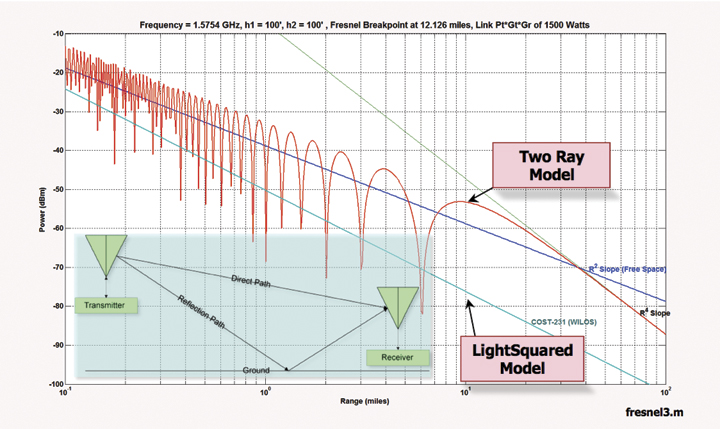
    • Even using the lower frequency spectrum in its new proposal (1526-1536MHz), at least tens (maybe hundreds) of thousands of your high-precision receivers will need to be replaced. Who will bear that cost?
    • More testing is needed to understand exactly what the effect of using only the lower frequency spectrum will have on all types of GPS receivers. That was not LightSquared’s original roll-out plan and therefore wasn’t tested extensively to determine its affect on GPS receivers.
    • The idea of using the upper frequency (1545-1555MHz) for high-powered terrestrial broadcast needs to be permanently abandoned.
    • The effect on GLONASS L1, Galileo L1, Compass L1, and GPS L1C need to be extensively tested to understand the effect on GNSS receivers of today and of the future. Galileo L1, Compass L1 and GPS L1C all use wider bandwidth than today’s GPS L1 C/A, which makes them even more susceptible to interference from LightSquared’s system.
    • A serious effort needs to be made to understand the effect of LightSquared’s mobile devices on GPS/GNSS receivers. LightSquared’s mobile devices will operate in the 1626.5-1660.5MHz frequency spectrum, above the GPS L1 spectrum and GLONASS L1 (~1597-1605MHz). It’s been reported that Inmarsat devices (using LightSquared’s 1626.5-1660.5MHz mobile device spectrum) do not fare well around Iridium phones (1616-1626.5MHz), which is very close to GLONASS L1.

    We have to be very careful and test these scenarios because once the plug is pulled, you can’t suck the water back out of the drain. There’s no turning back. Also, the FCC doesn’t have a solid history of making good decisions in the wireless arena. In the words of noted wireless industry guru Andrew Seybold (BlackBerry, HP, AT&T, Motorola):

    “The history of wireless is littered with examples where the FCC acted on a request by a vendor, approved the deployment of a system, and later learned that the new system created interference to other services.”

    In fact, Mr. Seybold writes that LightSquared shouldn’t be permitted to move forward at all. On July 6, 2011, he published the following:

    “Okay, I admit it. I don’t believe LightSquared should be permitted to use what was supposed to be satellite spectrum for a terrestrial broadband network. Not only that, I don’t believe LightSquared has a sound business plan. Building more than 40,000 cell sites, maintaining them, and reselling the bandwidth to others who want to sell it to its customers, does not pencil out in my book. The margins will be too slim, especially given the fact that prices for both voice and broadband services keep falling in the United States so margins will continue to be squeezed. But apart from a faulty business plan, the main reason I am opposed to LightSquared’s plan to build this network is that if there is the slightest chance it will interfere with GPS receivers, it simply should not be permitted to be built.”


    To file comments with the FCC: Comments may be filed electronically using the Internet by accessing the ECFS: http://fjallfoss.fcc.gov/ecfs2/. Filers should follow the instructions provided on the website for submitting comments. In completing the transmittal screen, ECFS filers should include their full name, U.S. Postal Service mailing address, and IB Docket No. 11-109.


    Thanks, and see you next time.
    Follow me on Twitter at http://twitter.com/GPSGIS_Eric


  • U.S. Defense, Transportation Say Keep Wireless Comm Away from L-Band

    The U.S. Departments of Defense and Transportation declared their strong opposition to the proposal of LightSquared Subsidiary LLC to operate a nationwide broadband service within the spectrum immediately adjacent to GPS signals, in a letter sent on June 14 to the National Telecommunications and Information Administration (NTIA). The agencies acted on behalf of the on behalf of the National Executive Committee for Space-Based Positioning, Navigation, and Timing, which they are responsible for co-chairing.

    The Departments asked the NTIA administrator to advise the Federal Communications Commission (FCC) to continue to withhold authorization for LightSquared to commence commercial service per its proposed deployment of a terrestrial service within the 1525-1559 MHz bands. LightSquared’s proposal is to deploy a network of 40,000 base stations along with some satellite coverage over 139 major markets in the United States.

    According to their official statement, “The Departments continue to support the National Broadband Plan, but cannot do so at the expense of a global, ubiquitous utility such as the Global Positioning System. The Departments encourage further assessment of any alternative spectrum and/or signal configuration plans.”

    The DoD/DoT letter was sent just prior to the original deadline for the final report of the Technical Working Group commissioned by the FCC to research and recommend on this matter. Certainly, the respective signers were cognizant of the contents of that report, at least on the test results regarding interference with GPS. As it turned out, on June 15 LightSquared asked for more time, and was granted a two-week extension. The final report was filed with the FCC on June 30.

    The Departments’ position followed an interagency review of the findings of the National Space-Based Positioning, Navigation, and Timing Systems Engineering Forum (NPEF),  tasked to assess the GPS impacts of LightSquared’s deployment plan as originally filed. The NPEF determined that, if permitted to operate as originally planned, LightSquared’s signals would significantly interfere with GPS users and, as a result, impact national security, economic security, and public safety nationwide. The NPEF report served as working material for the TWG report.

    The NTIA Administrator forwarded the letter and report to the FCC Chairman on July 6. These materials can be found at www.PNT.gov.

  • Final Report of FCC Working Group: Lose LightSquared from L-Band

    “Based on the analysis performed, LightSquared should not be permitted to use the L-Band spectrum for a densely-deployed, non-integrated terrestrial-only network. Such a network would cause unacceptable interference to GPS operations, wiping out an installed base of over 500 million units used in a wide array of public safety, aviation, industrial and consumer applications. While mitigation techniques utilizing filters were discussed in theory, they could not be tested as part of the WG effort because filters do not exist, even in prototypes. No information considered by the WG demonstrated that any mitigation techniques — other than relocation of the proposed terrestrial network to an alternative band — would be successful.” (From the U.S. GPS Industry Council’s overview of the WG report)

    The final report to the Federal Communications Commission (FCC) on three months of research by the technical working group (TWG) tasked to investigate and analyze effects of powerful terrestrial L-band transmitters on the GPS signal and services finally appeared on June 30, nearly two weeks after its assigned date. LightSquared had requested an extension, and apparently the lawyers on its staff used the extra time to write many pages of self-justification and further argumentation of the company’s case. But the facts are clear: the LightSquared signal would devastate services for users of all GPS receivers tested.

    The final report is not easy to find on the FCC’s labyrinthine website. Read the full “final report of the Working Group (WG) that was formed to study the GPS overload/desensitization issue as described by the Federal Communications Commission (FCC) in DA 11-133” here.

    See also four appendices:
    one, “Appendix A.1: MOPS Based Procedure for Minimum Recommended Testing of LightSquared RFI to GPS Aviation Receivers”
    two, “Appendix G.2: from Alcatel-Lucent Labs, LightSquared L-Band GPS Receiver Equipment Impact Evaluation Testing”
    three, “Appendix H.1.1: JPL/NASA Report on Laboratory Testing of Receivers for the Space-Based Sub-Team and the High Precision Sub-Team”
    and four, “Appendix H.1.10: High Precision Receivers – NAVAIR Anechoic Chamber Test Results.”

    Full data for all device tests conducted by the Working Group is available for download at: ftp://twg:[email protected]

    GPS World readers may also be interested in the thoughtful and intelligible analyses provided by the U.S. GPS Industry Council (“Overview of the Final Report of the Working Group”) and the Coalition to Save Our GPS (“FCC-Mandated Working Group Report Documents Pervasive Harmful Interference with GPS“).

    The TWG conclusions of widespread disruption and harm to GPS services are consistent with those reached by third parties that have reported independent analyses: RTCA, Inc., a Federal Advisory Committee that evaluates aviation, and the National Public Safety Telecommunications Council (NPSTC).

    “The TWG faced an extraordinary challenge of trying to determine if the laws of physics would allow the high-power LightSquared signals to co-exist in adjacent radio spectrum with the low-power satellite signals of GPS over and above the complex regulatory challenges of managing spectrum sharing,” said Charles Trimble, chairman of the U.S. GPS Industry Council. “In the end, the laws of physics won out.”

    Trimble, who co-chaired the TWG, added, “There is no single, simple solution that can eliminate interference for all classes of GPS receivers in the near term. GPS touches every aspect of our lives.  It goes beyond the most widely known navigation applications such as car navigation and cell phones to hugely important applications such as agriculture, electric power grids, communications networks, infrastructure monitoring and construction.”

    Regarding possible effective solutions, he offered the view that “greater separation of the LightSquared signals and those of GPS are necessary if the value of GPS is to be protected and broadband communications can grow to its potential over the long term.”

    In the area of high-precision receivers used for precision agriculture, survey, construction, machine control, mining, geographic information systems (GIS), structural deformation monitoring, and science, the group found that damaging interference existed at times at very long distances for the LightSquared transmitters. NovAtel president and CEO Michael Ritter said, “Allowing LightSquared to interfere with the utilization of these high precision receivers would eliminate the productivity improvements provided to these industries and applications during the past 20 years and will result in significantly higher prices for goods and services from these industries to the consumer.”

    Key Results and Findings from the WG Report:

    1. The LightSquared Terrestrial Broadband Service Will Cause Harmful Interference to Nearly All GPS Receivers and GPS-Dependent Applications

    2. Limited Testing of LightSquared Terrestrial Broadband Operations in the “Lower” 4G LTE Channel Does Not Eliminate Harmful Interference to GPS Receivers and GPS-Dependent Applications.

    3. Increasing Filtering on GPS Receivers Is Not an Available Mitigation Technique.

    •  No Suitable Filters Exist;
    •  Even if Filters Were Available, They Have Undesirable Performance Impacts on GPS Receivers That Have Not Been Evaluated.
    •  Increased Filtering Does Not Mitigate Interference to Hundreds of Millions of GPS Users in the Installed Base.

    4. The Only Feasible Solution to the Harmful Interference Effects LightSquared’s Proposed 4G LTE Terrestrial Broadband Service Will Cause to GPS Receivers and GPS-Dependent Applications Is to Relocate the LightSquared Service to Spectrum that is Not Adjacent to GPS/RNSS, outside of the L-Band.


  • The Economics of Disruption: $96 Billion Annually at Risk

    The Economics of Disruption: $96 Billion Annually at Risk

    The Economic Benefits of Commercial GPS Use in the United States and the Costs of Potential Disruption” was presented by Nam D. Pham, Ph.D., of NDP Consulting, during a June 21 webinar sponsored by the Coalition to Save Our GPS.

    The author stated that his study concentrated on GPS use in precision agriculture, construction, and surveying. It explicitly does not encompass GPS use in aviation, nor in the consumer sector, nor in timing or financial infrastructure.

    The report states: “The direct economic benefits of GPS technology on commercial GPS users are estimated to be over $67.6 billion per year in the United States. In addition, GPS technology creates direct and indirect positive spillover effects, such as emission reductions from fuel savings, health and safety gains in the work place, time savings, job creation, higher tax revenues, and improved public safety and national defense. Today, there are more than 3.3 million jobs that rely on GPS technology, including approximately 130,000 jobs in GPS manufacturing industries and 3.2 million in the downstream commercial GPS-intensive industries. The commercial GPS adoption rate is growing and expected to continue growing across industries as high financial returns have been demonstrated. Consequently, GPS technology will create $122.4 billion benefits per year and will directly affect more than 5.8 million jobs in the downstream commercial GPS-intensive industries when penetration of GPS technology reaches 100 percent.

    Further, “the GPS industry directly creates jobs and economic activities, which spur economic growth. Evidence shows that innovative industries, such as the GPS industry, create both high- and low-skilled jobs during economic expansions and downturns, pay their employees higher-than-national-average wages, raise output and sales per employee, increase U.S. competitiveness, which is reflected in increased exports and reduced U.S. trade deficits, and spend large sums on R&D and capital investment. In addition to creating these direct economic benefits, innovative industries create productivity benefits to the downstream industries, including increased sales, profits, and investment returns. Empirical studies have shown sustained productivity benefits support further growth and job creation in downstream industries and the U.S. economy as a whole.”

    Finally, “The direct economic costs of full GPS disruption to commercial GPS users and GPS manufacturers are estimated to be $96 billion per year in the United States, the equivalent of 0.7 percent of the U.S. economy. This annual total cost is the sum of $87.2 billion and $8.8 billion imposed on commercial GPS users and commercial GPS manufacturers, respectively. GPS user costs consist of $67.6 billion per year in foregone GPS benefits — increased productivity and input cost savings — and another $19.6 billion book value of investment losses in GPS equipment. GPS manufacturer costs consist of $8.3 billion per year in foregone commercial GPS equipment sales and an additional $0.55 billion per year in R&D spending and associated costs to attempt to mitigate the so-called LightSquared Problem.Systemn

    “If the operation of LightSquared will disrupt 50 percent of commercial GPS equipment, the direct economic impacts are expected to be $48.3 billion per year. Except the R&D spending and the opportunity cost of R&D spending performed by GPS manufacturers to find attempt to mitigate interference, direct economic costs to commercial GPS users and foregone GPS equipment sales are assumed to be half of total direct costs under the scenario of 100 percent degradation. In addition to direct economic impacts, there are other forgone direct and indirect economic and social benefits that are threatened by the LightSquared Problem. On the macroeconomic level, GPS disruption would reduce productivity and, consequently, hinder the competitiveness of GPS downstream users.”

    figure1
    Figure 1. Revenue shares of GPS equipment in North America, 2005–2010, according to Bone, Dominique and Stuart Carlaw, 2009, “Global Navigation Satellite Positioning Solutions,” ABI Research; and authors’ estimates.


    figure2
    Figure 2. Commercial GPS equipment revenues in North America, 2005–2010, according to Bone, Dominique and Stuart Carlaw, 2009, “Global Navigation Satellite Positioning Solutions,” ABI Research; and authors’ estimates.