Tag: mapping

  • Trimble NetR9 Reference Receiver Aimed at Infrastructure, Scientific, and Network Apps

    Trimble NetR9 Photo: Trimble
    Trimble NetR9. Photo: Trimble

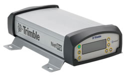
    Trimble has introduced an innovative Global Navigation Satellite System (GNSS) reference receiver for infrastructure, precise scientific, and network applications. The Trimble NetR9 GNSS reference receiver is a Continuously Operating Reference Station (CORS) receiver that can support the demanding applications for the earth science community and for the surveying, construction, mapping, and agricultural industries, Trimble said, adding that the NetR9 was designed to provide the user with maximum features and functionality from a single receiver.

    The Trimble NetR9 reference receiver offers 440 channels for robust GNSS constellation tracking. The receiver supports a wide range of satellite signals, including GPS and GLONASS signals. In addition, Trimble is committed to providing Galileo-compatible products in advance of Galileo system availability, the company said. In support of this plan, the Trimble receiver is capable of tracking the experimental Galileo GIOVE-A and GIOVE-B test satellites for signal evaluation and test purposes.

    The Trimble NetR9 reference receiver can be used as a standalone receiver or as part of a network solution. Specific applications include high-accuracy positioning as part of a Trimble VRS network, as a mobile field base station or CORS for real-time kinematic (RTK) corrections, as a scientific reference station collecting information for specialized studies, as a field campaign receiver for post-processing applications, and as support for Differential Global Positioning System (DGPS) coastal beacons. In addition, the Trimble NetR9 reference receiver can be used for monitoring the integrity of VRS networks as well as the deformation of physical infrastructure such as bridges, dams, mines, oil platforms, and other natural and manmade structures.

    The Trimble NetR9 reference receiver’s large internal memory (8 GB) allows post-processed results for base stations to be computed after survey completion, improving the accuracy of the survey. The highly compressed secure internal memory allows for more than 20 years of 15-second dual-frequency GPS data storage. In addition, the NetR9 also has USB logging capability for additional storage capacity, Trimble said.

    The receiver supports the new CMRx communications protocol, which provides correction compression for optimized bandwidth and full utilization of all satellites in view. This gives the customer more robust positioning data and reliable positioning performance, Trimble said.

    Optimized for field use with built-in rechargeable batteries, the NetR9 reference receiver consumes very little power and can be used for projects with remote connectivity and in extreme weather conditions. It has an IP67 rating, which means it is sealed against dust and can survive immersion in up to a meter of water for approximately 30 minutes. It also meets MIL-STD 810F standard for drops, vibration, and temperature extremes.

    The Trimble NetR9 has its physical memory built into the circuit board, providing greater protection of data, particularly under extreme conditions. Multiple built-in serial ports supply communications and power to support field use, whether connecting to a radio for RTK surveys, direct communication with a satellite phone for remote operations, or for ancillary input devices such as inclinometers and meteorological sensors, and it offers Bluetooth communication with a cell phone for real-time data streaming. In addition, both power and Ethernet can be supplied over a single cable using Power over Ethernet (PoE) technology.

  • On the Edge: Lost Graves, Trail of Tears

    By Steven M. Di Naso, Vincent P. Gutowski, Harvey Henson, and Ryan Leonard

    During the winter of 1838–39, the great Native American Cherokee Nation trekked across southern Illinois, in a forced removal by the U.S. government from their ancestral homeland in Tennessee. Harried, unequipped, and unsupported by their captors, thousands died on the Trail of Tears. Burial records were not kept, and burial locations remain lost to this day. Local history suggests that some Illinois settlers allowed the Cherokee to bury their dead on small plots of land adjacent to their own family cemeteries. One such plot, the Campground Presbyterian Church cemetery near Anna, Illinois, may contain unmarked Cherokee graves.

    Researchers from Southern Illinois University and Eastern Illinois University used GPS to navigate and precisely map probes of a ground-penetrating radar (GPR) instrument in the cemetery. We monumented the geophysical survey grids using real-time kinematic (RTK) DGPS. Site topography was also mapped using GPS, as were the individual cemetery headstones. Adding geographic information systems (GIS) software to our mix to map cemetery headstone distribution and record headstone attributes (dates of death, names), we could determine chronological gaps within the cemetery that coincide with the probable emigration of the Cherokee.


    GPR and electromagnetic conductivity produced contour plots of high-resolution magnetic gradient data. Small dipolar anomalies detected are typically related to disruptions within near-surface soil horizons and may correspond to locations of shallow graves: the lost final resting places of many Cherokee.

    By close examination of the geophysical survey data and the anomalies produced from them, we were able to present plausible if not possible locations of several gravesites. However, at this time, and for obvious reasons, the actual location must remain secure and cannot be published.

    The figure below shows a mosaic of amplitude depth slices at .30–.70 meter intervals from processed interpolated 250-MHz GPR profile data. White rectangles denote known graves. Most marked graves were imaged, although some were represented as more subtle anomalies on this display. Some possible unmarked graves were interpreted at UTM coordinates xxxx, yyyy.


    The cemetery is within working distance of CORS station ILCB at Southern Illinois University. Two RTK GPS units communicating with the station via CDMA cellular radio used real-time differential corrections along a variable baseline length of approximately 28.5 kilometers, enabling mapping of the site at centimeter-accuracy resolution.

    Survey data were edited, mapped, and analyzed with a GIS. Family genealogy polygons were generated using last names, to produce family distribution plots throughout the cemetery.


    Manufacturers

    The study, supported by a National Park Service grant with Southern Illinois University at Carbondale, used two Leica 1250 RTK GPS units, a Leica TC802 robotic total station, and Esri ArcGIS ArcInfo. Equipment was provided by Kara Company of Countryside, Illinois.

  • Apogee Offers Mapping, Geospatial Product Licenses for Educational Use

    Apogee Mapping has released amLibrary, a spatial data bundle that includes the company’s four flagship products and is packaged exclusively for use by higher education institutions.

    The bundle includes Apogee’s amElevation, amHillshade, amContour, and amWater. AmElevation is a national dataset of 1-arc second digital elevation data (DEM); amHillshade comprises nationwide 40, 200, and 1,000 foot contours in a smoothed vector format; amHillshade is a national set of tiled raster topography offered in both grayscale and full-color; and amWater is a premium vector hydrography dataset derived from information generated by the U.S. Environmental Protection Agency. AmLibrary also includes 50 data layers depicting environmental, climactic, and geologic data. Bundled together, this information provides GIS users with comprehensive and detailed terrain data that can be used as a basis upon which to conduct research and perform complex spatial analyses, according to Apogee Mapping.

    AmLibrary is offered exclusively to colleges and universities in either MapInfo TAB format or ESRI Shapefile format. Full product documentation, layer, and metadata are provided with the product.

  • 700,000 IKONOS Images Available through EVC Store

    East View Cartographic (EVC) has added 700,000 IKONOS satellite images to the online EVC Store. According to EVC, this is the first time that IKONOS imagery has been available in a fully functioning e-commerce environment complete with the support of experienced customer service representatives. Customers can browse available images geographically and place an order directly online, or get further personalized help from a representative.

    EVC President and CEO Kent Lee described this addition as “A significant step forward in online imagery sales. Customers can buy IKONOS imagery online as easily and quickly as they can book a flight on Expedia.” Lee added, “This will allow GIS professionals to easily order an IKONOS scene informed by full scene metadata and a large preview pane of the scene without having to wait for a quote. It will also allow customers without GIS experience to quickly see what is available over their area of interest.” East View Cartographic is an authorized reseller of IKONOS imagery via an agreement with GeoEye.

    This extensive catalog of satellite imagery could not be easily browsed and purchased online without EVC’s MetaLog Store. MetaLog Store is a robust platform with the ability to display large collections of data geographically, sort and filter using metadata, and allow online purchases. MetaLog Store powers EVC Store and is also available as a turnkey geospatial data management system.

    This selection of IKONOS imagery with less than 25 percent cloud cover is the first of EVC’s imagery offerings to be added to EVC Store. New IKONOS data will be added on an ongoing basis, and SPOT imagery will be added to the website in the near future. Currently, SPOT imagery, QuickBird imagery, customized IKONOS scenes, and additional satellite imagery can all be ordered through EVC customer service representatives.