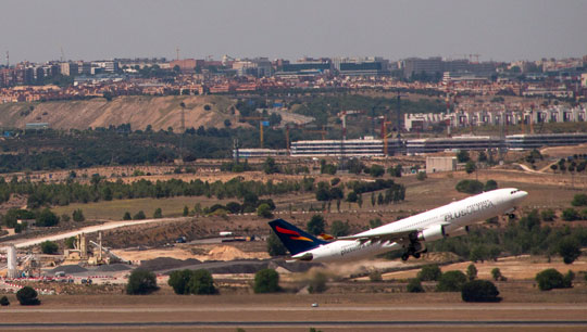
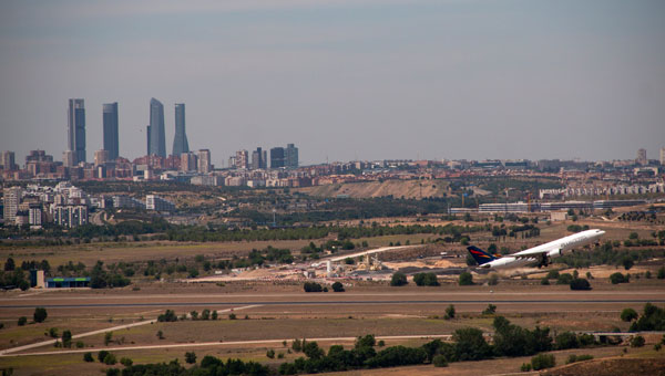
Skyfora, a Finnish weather data company building a new global data layer for weather and AI, has raised €6.5 million to transform GNSS telecom infrastructure into a real-time atmospheric sensing network.
The funding comes as demand for high-resolution weather data surges, driven by AI forecasting models, climate volatility, and the growing need for weather-resilient operations.
GNSS metrology system
Traditional weather forecasting relies on sparse networks of expensive ground stations, weather balloons, and radar systems — methods that leave vast gaps in coverage, particularly in urban areas and developing regions. Instead, Skyfora combines atmospheric physics, advanced signal processing, and artificial intelligence to extract weather intelligence from GNSS data.
GNSS meteorology turns every GNSS receiver into a weather sensor. The more receivers in an area, the higher the resolution of atmospheric data achievable.
GNSS signals traveling through the atmosphere are delayed by water vapor. By measuring these delays from multiple satellites and ground stations, Skyfora can create detailed 3D maps of atmospheric moisture — a critical input for weather forecasting.
Once the atmospheric data is captured and reconstructed, the system uses AI and high-performance computing to turn it into accurate, actionable forecasts.
Using existing GNSS receivers
Skyfora’s core technology uses GNSS receivers already installed in telecom networks, complemented by StreamGNSS hardware where telecom GNSS is not available, to measure atmospheric humidity with high precision and frequency. The GNSS signal delays are processed into real-time weather data streams that power next-generation AI weather models and forecasting systems, enabling more accurate, earlier, and hyperlocal predictions.
The company’s approach addresses a structural bottleneck in weather forecasting: most of the world’s atmosphere remains underobserved, and existing observation infrastructure cannot provide the data coverage and resolution required by modern AI models. Skyfora’s solution scales using existing infrastructure, requiring no new hardware at telecom sites.
Skyfora operates active deployments across multiple countries, working with telecom operators, meteorological institutions, forecasting partners and weather-affected industries to build out real-time atmospheric sensing on a global scale.
Latest capital round partners
The new capital will be used to accelerate the commercial scale-up of Skyfora’s software platform and atmospheric data products, expand partnerships with telecom operators, forecasting providers, meteorological institutions and weather-affected industries, and grow the team. The primary focus is on scaling deployment and market adoption: bringing Skyfora’s real-time data, API and atmospheric intelligence dashboard to market.
The round includes equity participation from Eviny Ventures, Ugly Duckling Ventures, Lumo Labs and the European Innovation Council (EIC) Fund, alongside non-dilutive funding from Business Finland.
The company is actively working to deploy datasets and customer opportunities across several countries in Europe, the United States, Africa and the Middle East.
ICAO Secretary-General Juan Carlos Salazar told delegates at the 2026 World Overflight Risk Conference in Vallarta, Malta, that emerging military technologies — including long-range weapons systems, unmanned aircraft systems (UAS), GNSS radio frequency interference, and advanced air defense systems — pose growing risks to civil aviation.
“We must now reach beyond the boundaries of aviation as we have known it,” Salazar said, adding that increasingly sophisticated weaponry is creating conditions in which civilian aircraft face a heightened risk of being targeted or caught in crossfire.
While praising the aviation industry’s ability to reroute flights and maintain operations during the recent Middle East crisis, Salazar said operational flexibility alone cannot address the underlying security threats posed by weapons systems.
He commended states and airspace users for measures taken to mitigate safety and security risks during the escalation in the Middle East, noting that more than 10 states partially or fully closed their airspace, significantly disrupting international air transport.
“This commitment to resilience, adaptation, safety and security is the foundation of our industry,” he said, calling for concrete steps to prevent civil aviation facilities, airports and aircraft from being targeted.
Salazar cited ICAO Assembly Resolution A42-4 and Article 3 bis of the Chicago Convention — which prohibit the use of weapons against civilian aircraft — as the legal basis for stronger protections. He said, however, that international law alone has proven insufficient as regional conflicts intensify.
Following ICAO guidance, Salazar urged states to take three immediate actions: rapidly share threat intelligence when activities pose risks to civilian aircraft; strengthen risk assessment and timely decision-making; and improve coordination between military and civilian authorities to prevent misidentification of civilian aircraft as military targets.
ICAO is finalizing a Global Crisis Management Framework to coordinate responses when civil aviation faces threats. Salazar said the reactive framework must be paired with proactive measures to prevent attacks.
The organization is also updating its Manual Concerning Safety Measures Relating to Military Activities and its Risk Assessment Manual for Civil Aircraft Operations Over or Near Conflict Zones, with a focus on improving how authorities, airlines and air navigation service providers assess threats from malicious activity.
Recent disruptions during the Middle East crisis demonstrated both the industry’s adaptability and the economic impact of operating in an increasingly militarized airspace environment. ICAO regional contingency frameworks have supported rerouting when airspace becomes unsafe, but officials said such measures are costly and temporary, not solutions to underlying security risks.
The two-day Malta conference, which opened April 21, brought together aviation officials and security experts from multiple regions to discuss implementation of safety protocols and information-sharing mechanisms. The Safer Skies initiative also serves as a framework for those discussions.
Salazar’s remarks mark one of ICAO’s most direct acknowledgments of growing risks to civil aviation arising from conflict zones, reflecting the organization’s core mission to maintain safe and secure international air travel amid rising geopolitical tensions.
Following the conference, Salazar met with Myriam Spiteri Debono to discuss global and regional developments affecting aviation, with a focus on the role of multilateral cooperation in addressing emerging challenges, including conflict-zone risks. He also commended Malta’s aviation sector.
Salazar was accompanied by Nicolas Rallo, director of ICAO’s European and North Atlantic Regional Office.
The Qatar Civil Aviation Authority (QCAA) this week is hosting the Joint ICAO Europe and North Atlantic (EUR/NAT) and Middle East (MID) Workshop on GNSS Radio Frequency Interference, reports the Qatar News Agency.
The workshop is organized jointly by the ICAO EUR/NAT and MID Regional Offices and is being held in Doha, Qatar, Nov.18-20.
In the opening session, Mohamed bin Faleh Al Hajri, QCAA manager, reaffirmed Qatar’s commitment to enhancing aviation safety and efficiency through close collaboration with ICAO and regional partners.
The workshop brings together countries and stakeholders from the EUR/NAT and MID regions to address the increasing threat that GNSS radio frequency interference poses to aviation safety and efficiency. Al Hajri emphasized the importance of active participation to exchange experiences, strengthen cooperation, and build sustainable partnerships that support GNSS resilience.
He highlighted that hosting the workshop reflects joint efforts aimed at strengthening the robustness and reliability of GNSS — a core pillar in ensuring the safety and efficiency of international air navigation.
Regional dialogue
The workshop aims to:
facilitate regional dialogue on the operational impact of GNSS radio frequency interference
share experiences among participating States and stakeholders
explore measures to improve reporting mechanisms, enhance mitigation strategies, and strengthen the overall resilience of satellite-based navigation systems.
It also seeks to reinforce cooperation between the EUR/NAT and MID Regions to safeguard the infrastructure and integrity of GNSS-based navigation systems.
The increasing prevalence of GNSS spoofing in commercial aviation poses significant safety concerns and highlights the need for robust alternative positioning, navigation and timing (A-PNT) sources. This form of electronic warfare, which uses fake signals to confuse aircraft navigation and safety systems, has become a growing issue for civilian flights worldwide.
Pilots told The Wall Street Journal that spoofing incidents have risen in recent months. According to analyses from SkAI Data Services and the Zurich University of Applied Sciences, the number of affected flights per day increased from a few dozen in February to more than 1,100 in August 2024.
The issue of spoofing has expanded beyond active conflict zones near Ukraine and the Middle East, and now affects hundreds of civilian pilots daily on a global scale. The modern cockpit’s heavy reliance on GPS technology means that falsified data can have far-reaching consequences, breaching multiple aircraft systems and causing disruptions that may last anywhere from a few minutes to an entire flight.
According to anonymized reports shared with government agencies and industry groups, pilots have experienced many alarming incidents, including sudden clock resets, false terrain warnings and unexpected flight path deviations. This surge in GNSS spoofing attacks highlights the vulnerability of critical navigation systems and raises significant concerns about aviation safety in an increasingly complex environment.
All jammed up The Wall Street Journal reported that in August 2024, a United Airlines flight from New Delhi to the New York area encountered a GPS spoofing incident that affected its navigation systems for the duration of the flight.
Initially, the flight seemed to adhere to the standard GPS route across Asia, mirroring the path taken by previous flights heading to Newark Liberty International Airport. The spoofing attack, originating in the Black Sea region south of Ukraine, caused the aircraft’s GPS coordinates to deviate progressively from its actual position throughout the remainder of the flight.
Even after the plane had left the affected area, its reported GPS location continued to show erratic behavior, occasionally making sudden jumps. This suggested that the navigation equipment was struggling to recalibrate accurately. While alternative navigation systems ensured the flight’s safe completion of its intended route, the compromised GPS data indicated that it had terminated in the Atlantic Ocean. In reality, the aircraft landed safely at its scheduled destination in Newark.
Keeping operations safe Aviation safety officials said spoofing has disrupted some flights but has not posed major safety risks. Pilots are trained to use A-PNT systems as backups. However, managing false GNSS signals and alerts risks dividing the operator’s attention if a more severe problem arises.
“If we lose an airplane because of workload issues because of these problems we’re encountering, compounded with an emergency, that is going to be a horrendous event,” said Ken Alexander, the Federal Aviation Administration’s chief scientist for satellite navigation, during a pilot union forum in Washington, D.C.
Airlines are collaborating with aircraft manufacturers, parts suppliers, and aviation safety authorities to devise immediate solutions and long-term strategies. For example, the International Air Transport Association (IATA) and the European Union Aviation Safety Agency (EASA) are openly discussing these challenges and holding workshops to share best practices. Safety bulletins have also been issued for operations where spoofing and jamming are known to have occurred.
Industry insiders told The Wall Street Journal that the development of new equipment standards to enhance civilian aircraft resilience against spoofing attacks is not expected to be finalized until 2025.
Navigating issues across sectors According to anonymized reports collected by OpsGroup, an aviation safety organization that includes pilots, dispatchers and other airline staff, various attacks have caused navigation issues across multiple sectors.
GNSS spoofing has disrupted operations in Europe but has not endangered flights, said Florian Guillermet, executive director of the European Union Aviation Safety Agency. Pilots had to divert to airports they did not intend to land at, and earlier this year, an airline temporarily halted operations at an Estonian airport that was not equipped with ground-based navigation as a backup for GNSS.
Boeing said manufacturers, carriers and regulators globally are contributing GPS expertise for solutions to ensure safety. Boeing and Airbus are working with airlines to help develop procedures to assist pilots, the companies said.
United and American said their pilots are equipped with several ways to navigate with precision, even with GPS interference. American said it has not experienced disruptions or significant safety concerns from GPS interference.
Insights from industry experts
During the 64th Civil GPS Service Interface Committee Meeting — hosted at ION GNSS+ 2024 from Sept. 16-17 — The presentation “Complementing GNSS for Resilient Performance Based Navigation” by Okuary Osechas Ph.D., and Gary A. McGraw, Ph.D., addressed the critical role of complementary positioning, navigation and timing (CPNT) technologies in aviation, particularly in light of increasing threats to GNSS.
The presentation highlights the impact of radio frequency interference (RFI) on aviation, including jamming and spoofing. These pose significant risks to aviation safety by reducing operational margins. The prevalence of these threats is increasing, necessitating alternative navigation solutions.
Performance-based navigation (PBN) is essential for modern aviation, enhancing efficiency and flexibility. However, it relies heavily on GNSS, making it vulnerable to disruptions, again highlighting the need for CPNT services.
Integrating CPNT sources ensures resilient navigation capabilities. This includes leveraging legacy navigation aids and modernized terrestrial systems. Various complementary technologies such as eDME, eLORAN, LDACS-NAV and LEO SATNAV are being assessed for their operational effectiveness, compatibility and potential to support aviation needs.
The researchers recommend the following to address these challenges:
Near-term solutions: Implementing eDME for backward compatibility. Medium-term strategies: Utilizing eLORAN for wide-area time distribution. Long-term goals: Developing LDACS-NAV to enhance spectrum efficiency and standardization. Collaborative efforts: The presentation calls for international cooperation in research and development to advance standards and infrastructure investments in complementary PNT technologies.
Researchers from the University of Texas at Austin have identified an Israeli air base as a large source of widespread GPS disruptions affecting civilian airline navigation in the Middle East, reported TheNew York Times.
The spoofing disruptions involve the transmission of manipulated GPS signals, which can cause airplane instruments to misread their location. Lead researchers Todd Humphreys and Zach Clements stated they are “highly confident” that Ein Shemer Airfield in northern Israel is the source of these attacks. The Israeli military declined TheNew York Times’request forcomment.
The research team utilized data emitted by the spoofer and picked up by satellites in low-Earth orbit (LEO) to determine its location. They then confirmed their calculations using ground data collected in Israel.
Spoofing, along with GPS jamming, has significantly increased over the past three years, especially near war zones such as Ukraine and Gaza. In these areas, militaries interfere with navigation signals to redirect aerial attacks.
The Middle East has emerged as a hotspot for GPS spoofing, with TheNew York Timesreporting that a separate analysis estimatesmore than50,000 flights have been affected in the region in 2024 alone. Researchers from SkAI Data Services and the Zurich University of Applied Sciences, analyzeding data from the OpenSky Network and, found that these attacks have led pilots to mistakenly believe they were above airports in Beirut or Cairo.
Swiss International Air Lines told TheNew York TimesNYTthat their flights are spoofed “almost every day over the Middle East.”
The issue extends beyond the region, with Estonia and other Baltic nations having blamed Russia for disrupting signals in their airspaces. Additionally, in April 2024, Finnair temporarily suspended flights to Tartu, Estonia, amid the rise of GPS jamming in the region affecting civilian air travel.
The attacks have not led to significant safety risks as pilots can use alternative navigation methods. However, they do raise concerns.
Jeremy Bennington, vice president of Spirent Communications, told TheNew York Times, “Losing GPS is not going to cause airplanes to fall out of the sky. But I also don’t want to deny the fact that we are removing layers of safety.”
The spoofing attacks may cause false alerts about planes being too close to the ground, leading to navigation confusion and possibly compromising flight safety.
As these disruptions continue to affect large areas far from active conflict zones, the aviation industry and international authorities are under increasing pressure to address this emerging threat to air travel security.
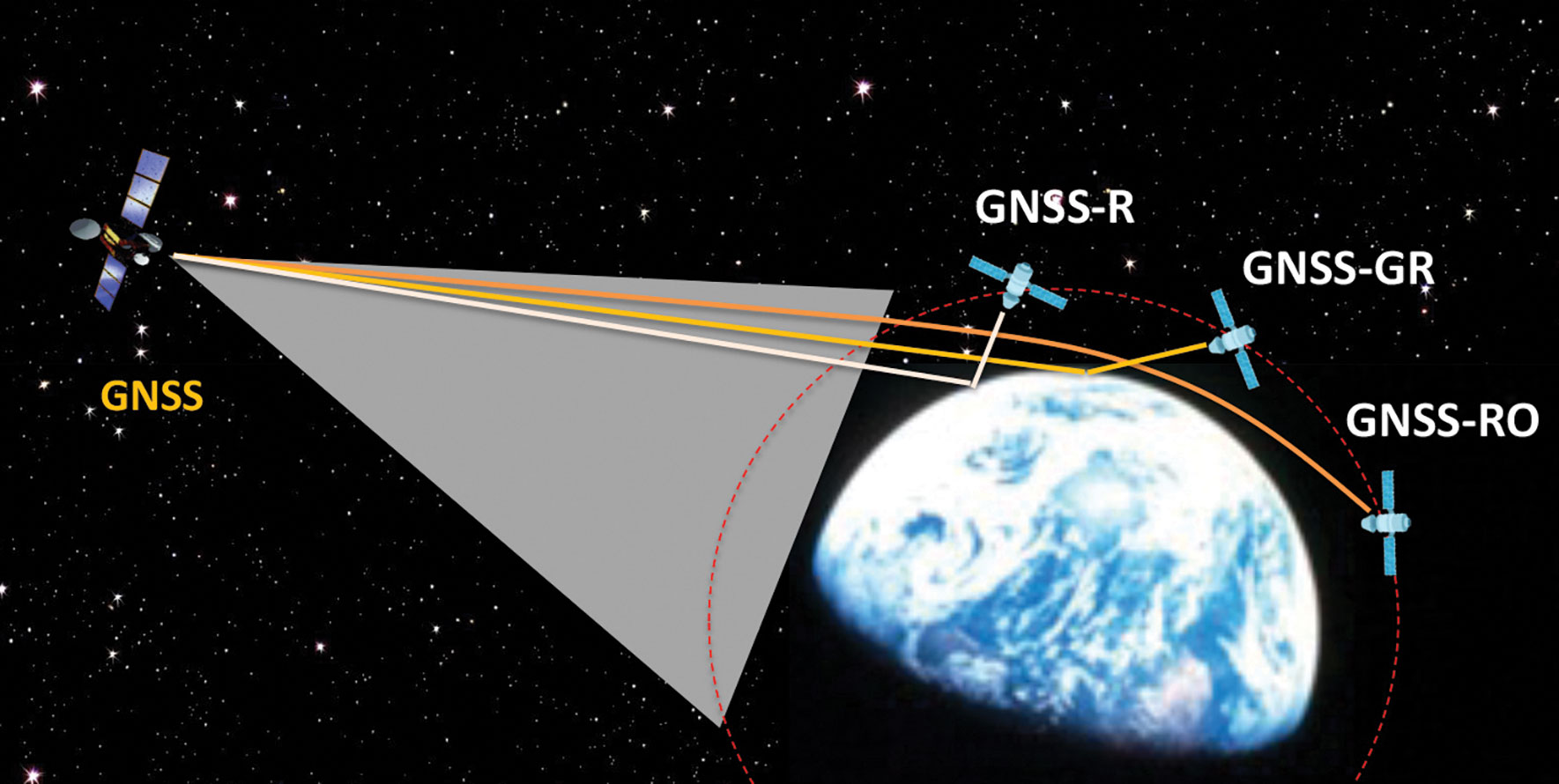
Figure 1: Scientific observations with GNSS radio occultation (GNSS-RO), GNSS grazing-angle reflectometry (GNSS-GR) and GNSS reflectometry (GNSS-R) techniques from low-Earth orbit (LEO). (Figure provided by the author)
Global navigation satellite systems (GNSS) for peaceful uses are facing a hard reality due to increasing regional conflicts in recent years. As a dual-use technology, GNSS for civil, commercial and scientific applications is vulnerable to both denied/degraded service and flex power operation from GNSS satellites and to jamming from the ground.
One of the vulnerable scientific applications is the use of GNSS receivers on low-Earth orbit (LEO) satellites that utilize the civil navigation signals for Earth observation. These remote sensing techniques, such as GNSS radio occultation (GNSS-RO), GNSS grazing-angle reflectometry (GNSS-GR) and GNSS reflectometry (GNSS-R) (see figure 1), are designed to observe weak GNSS signals either bounced off from Earth’s surface or refracted by the atmosphere. Thus, GNSS flex power operation and intentional radio frequency interference (RFI) can severely degrade the quality of the scientific data or even prevent Earth observation.
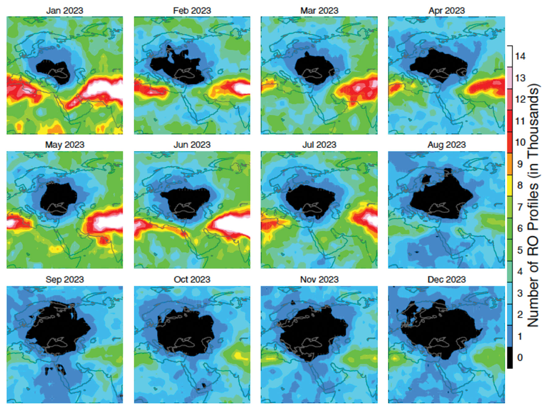
One example of such impacts is a dramatic decrease of GNSS-RO observations over Europe and the Middle East during 2023. Monthly statistics from Spire show the region without GPS-RO measurements grew substantially from the localized Ukraine-Russia conflict zone in January to a much wider area in Eastern Europe and the Middle East in December 2023 (see figure 2).
Figure 2: Number density distribution of monthly GNSS-RO measurements from the GPS tracking by the Spire constellation over Europe and the Middle East in 2023. The black area indicates no data. (Figure provided by the author)
This vast data void in the science observation is likely a result of the intensified electronic warfare used in Ukraine-Russia and the nearby conflict regions. The Spire RO receivers are configured to track the civil signals from GPS, GLONASS and Galileo. To increase signal protection against jamming in a conflict zone, GNSS service providers often use flex power operation. However, flex power operations can cause poor quality tracking with the RO receiver due to weaker signal power. Unlike a precise orbit determination (POD) antenna, the GNSS-RO antennas typically have a high gain to improve the detection of weak GNSS signals at limb and occulted views. However, if the transmitter power of civil signals drops below a quality-control (QC) threshold, the data are flagged as bad. This results in a poor coverage of Spire GNSS-RO in the conflict zones.
Lost or degraded GNSS-RO, GNSS-R and GNSS-GR observations are unfortunate, as these all-weather sensing, long-term stability, and high-accuracy measurements are becoming increasingly important in scientific research. GNSS-RO is a remote sensing technique that uses the GNSS-LEO link to profile Earth’s atmosphere and ionosphere with high vertical resolution. Since the first GNSS-RO six-satellite constellation, known as Constellation Observing System for Meteorology, Ionosphere and Climate-1 (COSMIC-1), these high-quality RO profiles have become a key data source for weather forecasting, climate monitoring, model evaluation, and space weather research. The current backbone of GNSS-RO observations comes from the COSMIIC-2 and Spire constellations, which have been producing more than 20,000 profiles per day since 2020. GNSS-R is a bi-static radar technique that uses the GNSS signals reflected by the surface for altimetry, ocean surface wind speed, wave height sea ice, soil moisture, and inundation measurements. At a view angle between GNSS-RO and GNSS-R, GNSS-GR can provide complementary measurements for sea ice and atmospheric column water vapor. Because of low-cost LEO SmallSat/CubeSat constellations with the GNSS receivers, geoscience studies have benefited greatly from the sampling density and coverage of these new data.
Civilization and science have been diverted by wars before. Despite the increased dependence on GNSS in recent years, their vulnerability to jamming and flex power operation poses a great challenge for scientific observations that need uniform global coverage.
NASA’s Ingenuity took this picture on Jan. 18, 2024. The sand-dune, rock-less area where Ingenuity last showing the shadow of its damaged rotor blade. (Image: NASA)
It appears that the little extraterrestrial drone that could has come a cropper on Mars and now will not be flying again – it is permanently grounded. The Jet Propulsion Lab (JPL) crew managing Ingenuity was running a regular scouting trip over a featureless sand-dune area on Dec. 22, 2023. Suddenly, the UAV’s visual navigation system malfunctioned, which led to a hard emergency landing.
When the autonomous navigation system did not have any landmarks to match its digital reference map, it reverted to an emergency landing. Maybe the poor guy should have had a few moments to gather its airborne wits and to come down softly, but alas at the same time the connection with the rover was lost, he dove for cover and broke a chunk off at least one of the counter-rotating blades. This now apparently prevents further take-offs. Mars’ atmosphere is only 1% as dense as Earth’s, so those rotors need all their designed lift capabilities to grab enough ‘air’ and get the 4 lb helicopter airborne. The flight control system may be unable to cope with the resulting compromised lift profile. Either way Ingenuity’s flying days are over, according to NASA.
Conceptual design for the Sample Recovery Helicopters (Image: Aerovironment/ NASA/ JPL)
Ingenuity completed 72 flights over the course of three years, surpassing its original 30-day mission to prove the possibility of a miniature, autonomous helicopter flight on Mars. After its initial four flights, NASA and JPL chose the UAV to scout out safe paths for the Perseverance rover from an airborne perspective.
All is not lost for Ingenuity, however. AeroVironment, the UAV manufacturer that co-developed Ingenuity with NASA/JPL, has been awarded another contract to design and develop two prototype ‘sample-return’ helicopters for NASA’s next major Mars expedition.
Building on Ingenuity’s design, the new UAV will have wheels and a grappling contraption to pick up sample tubes, which could assist in the Mars sample recovery mission. Perseverance is currently expected to be the lead in transferring cached sample tubes to the new Sample Retrieval Lander for return to Earth, but the new helicopters provide a different backup option on Mars for pick-up and transport of the tubes.
Back here on Earth, the latest tragic news from the Middle East — the UAV attack on the US Tower 22 military outpost in Jordan which cost three soldiers their lives and injured at least 34 others — appears to have been due to a lack of defensive capability. Earlier news releases indicated that the kamikaze UAV had arrived at the same time as the expected return of a U.S. UAV from the base, implying that defenses may have been taken down temporarily. It now seems that there was little active defense to prevent the attack.
The attacking UAV reportedly came in very low, and the base was unable to track its approach. The base is said to have defensive signal jamming capabilities, but without radar visibility of the UAV and knowing an attack was in progress, the jammers may have been ineffective or inactive.
Tower 22 was thought of as a low-risk-of-attack U.S. base, perhaps supporting another U.S. base in Syria with logistics, so no active drone suppression system had been provisioned. This assessment, and those for similar bases in the area and around the world, may perhaps have to be revised and sufficient active defenses may need to be installed.
While U.S. and Ukrainian forces deal with attacking drones, Iran has unveiled its latest addition to its arsenal of one-way killer unmanned aircraft.
Image: Iranian Military Media
Iran displayed the Shahed-238 in public in November 2023, so there may have already been enough time to get some of these very fast-flying vehicles through the manufacturing process and begin deliveries to Russia and Iranian proxy agents. The advantage of jet-power is of course significant speed over propeller-driven variants, while the range may be significantly less for the same fuel capacity. The disadvantage for the United States and Ukraine is that most fielded conventional UAV detection radars have difficulty seeing fast targets in time to activate and aim defensive weapons.
The situation for Ukraine and the United States in the Middle East appears to be worsening as large numbers of Iranian-supplied and locally manufactured kamikaze UAVs are pumped into the war zone and ‘hot spots’ in the Middle East.
It is sad that Mars aerial views may be limited as Ingenuity seems to be permanently grounded, and the Middle East doesn’t sound too safe to be hanging around in either! Further escalation of prices might be expected, too, as a good part of the volume of cargo ships settle into sailing around Africa. Let’s look for better news in the coming months.
Three U.S. service members were killed and dozens wounded during a UAV attack on U.S. forces stationed in northeastern Jordan near the Syrian border, President Joe Biden and U.S. officials said on January 28.
Biden blamed Iran-backed groups for the attack, the first deadly strike against U.S. forces since the Israel-Hamas war erupted in October 2023 and sent shock waves throughout the Middle East.
“While we are still gathering the facts of this attack, we know it was carried out by radical Iran-backed militant groups operating in Syria and Iraq,” Biden said in a statement.
At least 34 personnel were being evaluated for possible traumatic brain injury, a U.S. official told Reuters, speaking on the condition of anonymity. Two officials said some wounded U.S. forces were medically evacuated from the base for further treatment.
The Islamic Resistance in Iraq – an umbrella organization of Iran-backed militant groups — claimed attacks on three bases, including one on the Jordan-Syria border.
The attack is a major escalation in the already tense situation in the Middle East, where war broke out in Gaza after the Palestinian Islamist group Hamas attacked Israel on October 7, killing 1,200 people. Israel’s subsequent assault on Gaza has killed more than 26,000 Palestinians as of January 2024, according to the local health ministry.
Since then, U.S. forces have come under attack more than 150 times by Iran-backed groups in Iraq and Syria. U.S. warships have also been fired at by Iran-backed Houthi forces in Yemen, who are regularly attacking commercial ships passing through Red Sea waters off Yemen’s coast.
While the United States has maintained an official line that Washington is not at war in the region, it has been retaliating against the Iran-backed groups in Iraq and Syria and carrying out strikes against Yemen’s Houthi military capabilities.
Referring to the fallen soldiers, in his statement released by the White House Biden said: “We will carry on their commitment to fight terrorism. And have no doubt — we will hold all those responsible to account at a time and in a manner of our choosing.”
Electronic warfare in the Middle East and Ukraine is affecting air travel far beyond the battlefields, unnerving pilots and revealing unintended consequences of a tactic that experts believe will become more widespread, reportedThe New York Times.
Planes are losing satellite signals, flights have been diverted and pilots have received false location reports or inaccurate warnings that they were flying close to terrain, according to European Union safety regulators and an internal airline memo viewed by The New York Times. The Federal Aviation Administration (FAA) has also warned pilots about GPS jamming in the Middle East.
Following Russia’s invasion of Ukraine in early 2022, radio frequency interference only continues to increase across the Middle East as of autumn 2023. These interferences can involve jamming GNSS signals to obstruct or block them using noise, or mimicking signals to trick GNSS receivers into picking up counterfeit satellite signals, known as spoofing.
Aircraft systems have been unable to detect GPS spoofing and ultimately correct for it. According to Opsgroup, an organization that monitors changes and risks in the aviation industry, one Embraer jet bound for Dubai nearly veered into Iranian airspace in September before the pilots figured out the plane was chasing a false signal.
“We only realized there was an issue because the autopilot started turning to the left and right, so it was obvious that something was wrong,” crew members reported to Opsgroup.
Issues arise
With the rise of electronic warfare, the strain on aviation could be a sign of more serious economic and security issues.
The U.S. government calls GNSS signals “an invisible utility.” Smartphones, cars, stock exchanges, data centers and countless industries rely on them for time, navigation or both. Similar systems exist around the world, such as Galileo in Europe, Glonass in Russia, QZSS in Japan, NavIC in India and BeiDou in China. One study from Britain said a five-day disruption of satellite signals could cost the country $6.3 billion.
Minor interference with GPS signals is fairly common. GPS jamming devices, while illegal to use, are inexpensive and easy to obtain from vendors on the internet. Governments, too, have been more willing to overtly interfere with signals as a tactic in electronic warfare.
It is not always possible to distinguish jamming from spoofing, or to determine who is behind the interference. Israel said in mid-October it had restricted GPS in the region and had warned pilots not to rely on satellite navigation systems for landing.
Russian interference is well-documented. A 2019 report by the Washington-based analytical nonprofit group C4ADS showed extensive spoofing from a Russian-controlled air base in Syria. Reports also indicated that, when Russian President, Vladimir Putin, traveled to remote locations or Russian-occupied Crimea, he was flanked by mobile GPS-spoofing technology.
Jamming is common in conflict zones. Spoofing, until recently, was considered rare.
The interference has been felt up to 190 miles away from battlefields and “appears to go well beyond simple military mission effectiveness,” according to Eurocontrol, Europe’s primary air-traffic-control manager. The worst-affected regions include the aerial space above the Black Sea area from Turkey to Azerbaijan; the Mediterranean Sea extending from Cyprus to Libya; the Baltic Sea near Poland and Latvia; and the Arctic near Finland and Norway.
Airbus said it recorded nearly 50,000 interference events on its aircraft last year, more than four times as many as the year before. This came on top of an over twentyfold jump in radio-interference events from 2017 to 2018, as recorded by a voluntary incident reporting system run by Eurocontrol. Eurocontrol said the increased jamming since 2018 was most likely meant to interfere with battlefield UAVs.
In the Middle East, there have been reports of false signals telling pilots their aircraft were directly above the airport in Tel Aviv despite being far away. Opsgroup said it had received around 50 similar reports. In some cases, onboard equipment showed that planes were approaching airports in Baghdad, Cairo or Beirut, Lebanon, when they were not.
Looking ahead
Spoofing is hard to distinguish because the signal appears legitimate. Only Europe’s Galileo incorporates an authentication system that can verify when a signal is from its satellites. Galileo, which currently is the most accurate and precise navigation satellite system, plans to introduce an even stronger level of authentication, according to the European Commission.
But even Galileo’s authentication cannot protect against one of the most dreaded types of spoofing, known as “meaconing.” In a meaconing attack, a spoofer would record satellite signals, and then rebroadcast them with an amplification or a delay. Experts have not publicly confirmed any meaconing attacks in the Middle East.
Opsgroup said the latest events should prompt manufacturers to re-examine the integration of satellite signals in aircraft electronics, known as avionics, without a safeguard that can identify false signals.
In this environment of intentional GPS jamming and spoofing, Israel has produced a leading anti-jam technology company, InfiniDome, located in Caesarea. According to co-founder Omer Sharar, the company has been working to defend GPS signals for more than seven years and has also seen the rise of devices to jam the GPS L1 frequency that anyone can buy online for $100.
Most readily available jammer electronics only output interference disrupting GPS L1, which is commonly installed for vehicle tracking and UAV guidance. InfiniDome says it has successfully protected trucking, UAV operations and others in Israel and around the world with its Infinidome GPSdome-1 and GPSdome-2 anti-jam products.
It is clear the conflict’s repercussions extend well beyond the battlefield, highlighting the critical need for security assessments or alternative PNT systems to protect civilians. While there is going to be a significant impact on commercial airline travel to and from Israel while hostilities continue, there is hope for a possible long-term solution for the intense jamming that has plagued the region for years.
In March, the U.S. government received an unusual inquiry about GPS disruptions. It was from a user in Iran reporting what appeared to be “circle spoofing” — a phenomenon that had only previously been observed in China.
“Some of GPS devices received fake signal and show the fake valid location. Yesterday I test a device, it can get signal and give real position. After 10 minutes the device show moving around a big circle in tehran by 35 km/h speed. I can’t fix this problem by restarting the device.
“The GPS module time is correct but the location is not. I attach Excel file of data and map of the track. I can’t get any response from Communications Regulatory Authority (CRA) of The I.R. of Iran. Do you know about this?”
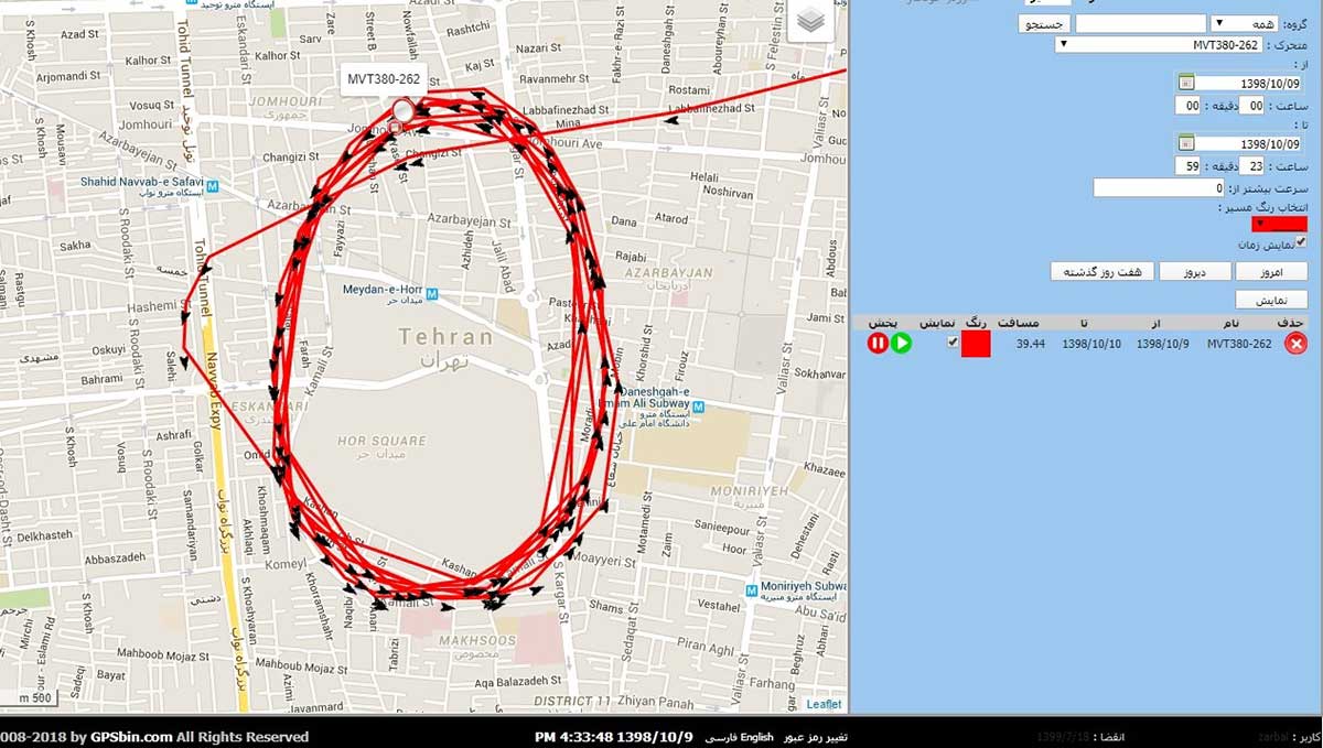
Here is one of the images provided by the reporting source:
GPS spoofing device in operation at Iran’s Army Command and Staff College. (Screenshot courtesy of Dana Goward)
A little internet research showed that the spoofing was taking place at or near Iran’s “AJA University of Command and Staff,” formerly called the “War University.” It is the staff college for Iran’s Army.
Reports to the U.S. government about GPS disruption are normally listed on the U.S. Coast Guard’s Navigation Center website. This one has not been posted. Coast Guard officials said that it is because the report was received by another agency and did not contain sufficient information. Attempts by Coast Guard personnel to contact the reporting source for more information to enable the report to be posted were unsuccessful.
GPS spoofing is often easiest to detect in maritime areas. Ship automatic identification system (AIS) transmissions include location data and are detected by satellite. The data is then aggregated and used by various companies for a number of applications. Viewing ship location reports over time has revealed thousands of ship receivers spoofed to airports in Russia, and hundreds spoofed into circles (presumably around the spoofing device) in China.
Clearly, though, any system that aggregates and displays GPS location data can help detect wide area spoofing activity.
Strava is a mobile app for runners and cyclists. The company aggregates location data and displays it on a heat map to highlight athletes’ favorite routes.
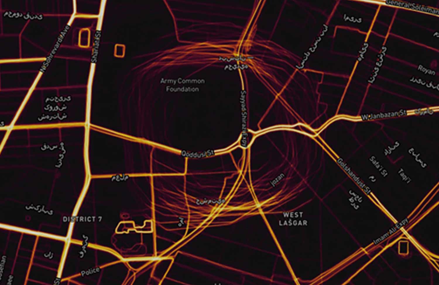
The Strava heat map for Tehran shows that circle spoofing has also been employed in at least one other location. The below screenshot shows GPS-enabled fitness trackers circling a government complex that houses offices for several defense and technology-related organizations.
This heat map shows GPS spoofing at a government complex in Tehran,which houses the Ministry of Defense, Communication Regulatory Authority, Telecommunications Infrastructure Company, and Ministry of Telecommunications and Technology. (Screenshot: courtesy of Dana Goward)
Iran was the first nation to publicly announce it had the ability to spoof GPS signals and seems to have used it to great advantage.
In 2011, a CIA drone that had been operating across the border in Afghanistan landed at an Iranian airfield. Iran’s government claimed that its forces had sent false signals to the drone’s GPS receiver in order to capture it.
At first, U.S. government officials said that this kind of spoofing was not possible. Several months later, Prof. Todd Humphreys demonstrated how it could be done to a drone at the University of Texas football stadium.
U.S. officials then admitted that spoofing was possible, but said it wasn’t what happened to the CIA drone. At the same time, they offered no alternate explanation of how the drone was captured.
In 2016 Iranian forces captured two U.S. Navy boats that had strayed into Iran’s territorial waters. This was just after President Obama had succeeded in pressing that nation to give up nuclear weapons research, and was on the same day as Obama’s last State of the Union address. There was little reason for the U.S. Navy boats to have veered so far off course, and it was clear that the Iranian Navy was waiting for them.
Many speculated that Iran had spoofed GPS signals to lure the U.S. Navy boats into Iranian waters. U.S. officials have denied that this was the cause of the incident, but have not publicly offered an alternate explanation other than “mis-navigation.”
During heightened tensions in the Persian Gulf in 2019, Iran shot down a U.S. surveillance drone and President Trump seemed ready to launch a retaliatory strike. This was called off at the last minute. According to some reports, the strike was canceled because of the likelihood the drone was in Iranian airspace at the time.
At about the same time British intelligence was warning merchant vessels in the area that Iran was attempting to use GPS spoofing to lure them into Iranian waters as a pretext for seizing the ships.
While the Middle East has been a hotbed of jamming and conventional spoofing for years, these recent circle-spoofing incidents are the first of the kind we know of in the region. It may well be that Iranian forces have recently received equipment from China and are experimenting with it. They could also be using it to deter GPS guided drones and disrupt other surveillance systems in the vicinity of sensitive government facilities.
As part of the Open Geospatial Consortium’s (OGC) Testbed 13, the OGC is requesting information to identify, assess and gather the current state and available geospatial data and services in the Europe and Middle East regions that may be used to support the development, testing and demonstration of OGC standards and technologies advanced during Testbed 13.
OGC Testbed 13 participants will implement services, access data, and demonstrate capabilities using the services and data identified during this request for information (RFI).
The overarching theme for Testbed 13 is mass population migration. The Testbed aims to understand and document how information sharing and safeguarding tools and practices — including open geospatial standards — can enable cross-domain interoperability on an international level for structured communication exchange and border surveillance to assist law enforcement and humanitarian aid operations.
The demonstration scenario for Testbed 13 will focus on addressing challenges related to the coordination of multi-regional/national operations arising from the current exodus of people from the Middle East to Europe. This includes any messaging related to the displacement and mass movement of populations in response to conflict.
As an OGC Innovation Program initiative, Testbed 13 will investigate and develop new or enhanced OGC web service or encoding specifications over a wide variety of technology work areas. These technologies will be tested and demonstrated in an architecture and a deployed environment in support of the mass migration theme, as shown in the following diagram:
A wide variety of source data or data provider services available for public use are needed to support the scenarios and use cases associated with this testbed. As such, OGC is looking for your help in providing us with information on the availability of these data and services.
The following is a partial list of types of source data or services, required over the area of interest, that could support the development of, and testing in, Testbed 13:
Map data and/or services
Feature data and/or services, such as road networks, rivers, water bodies or water sources, jurisdictional boundaries, etc.
Satellite imagery and/or services
Predictive model related data, such as base and ancillary data as well as outputs of predictive models
Medical and Health facilities and locations (or could be part of other feature data sources or services)
Recommendations for additional source data or services that provide data of various types across the region of interest, are available for public use, and could support the scenario, development, and testing in Testbed 13, are welcome and encouraged.
For more information on Testbed 13, view the Call for Participation. The RFI is available for download. Instructions on how to submit responses to, or questions concerning, the RFI are available in the download.
LizardTech, a provider of software solutions for managing and distributing geospatial content, has expanded its global presence with several new business partnerships and product purchases during the first half of 2015.
During the last six months, national governments, energy organizations and infrastructure owners and operators have all bought LizardTech software in countries such as Canada, Sweden, Norway, Germany, United Kingdom, Spain, South Africa, Saudi Arabia, Turkey, Oman, Australia and the Philippines.
“We are delighted with the progress we have made in promoting LizardTech’s remarkable MrSID-based software throughout the European, African and Middle Eastern market places and beyond into Asia Pacific,” said Quarry One Eleven Founder Alistair Maclenan. “LizardTech is a great client that understands the power of marketing and in-region representation. Their support has been a huge factor in the partnership and sales successes we have seen for their image compression, preparation and distribution products.”
“We have had an exciting first half of the year which illustrates that our products are in demand all over the world,” said Jeff Young, who directs Global Business Development at LizardTech. “These sales validate the sustainability of LizardTech over the last 23 years through partnerships in multiple continents. We take pride in our customer’s loyalty and continued commitment to our MrSID image compression format.”