CoreLogic announced its patented ParcelPoint technology has expanded to include data coverage for 138.5 million parcels, 97 percent of which are actual parcel boundary polygons.
According to the announcement, it is the most comprehensive parcel database in the U.S., covering 2,605 counties across the country. CoreLogic has maintained the nation’s largest parcel database since 2008, when initial coverage totaled 90 million parcels.
The company reports that the ParcelPoint spatial data provides the parcel boundaries and centroid points defined by actual latitude/longitude coordinates that are vital to identifying the geographic location of an individual property, ownership information, as well as property address and assessor parcel number (APN). Data is sourced from public records in various formats, and are then checked for geometric errors, positional accuracy, and attribution. The parcels are standardized for consistency and then incorporated into a spatial dataset to create uniform information for widespread use.
Esri introduces the public beta version of its cloud-based Geotrigger Service that helps developers easily create location-aware apps for iPhone and Android without compromising battery life. The beta Geotrigger Service is available at no cost and feedback from developers will be used to shape the official release.
The Geotrigger Service allows apps built on the Esri location platform to quickly gather business intelligence such as where people are and when the app is used. Developers can also design apps that send messages to users when they arrive at or leave areas defined by a geofence.
“On the Esri location platform, we already offer a host of services for developers from geocoding and geoenrichment to routing maps. The Geotrigger Service boosts this offering with location-awareness and location-based alerts,” said Johan Herrlin, Esri’s senior business strategist.
Developers can use the Geotrigger Service for apps across all industries including:
·Retail and Loyalty: Engage customers with personalized content and deals the moment they enter a store.
·Real Estate: Send messages to prospective home buyers when their search criterion matches a nearby home.
·Energy Management: Use location to automatically manage power consumption at home or in the office.
·Tourism: Bring public attractions to life by informing tourists of interesting locations as they explore a city.
·Public Alerts: Notify citizens about events such as road closures or civic emergencies based on past locations.
Qualcomm Incorporated has announced that its subsidiary, Qualcomm Technologies, Inc., is enhancing location precision in smartphones and tablets initially in China with support for China’s BeiDou Satellite Navigation System.
Supporting the BeiDou constellation within Qualcomm IZat location solutions increases the number of satellites that Qualcomm-based devices can access to provide greater position location accuracy. Qualcomm is collaborating with Samsung to launch the first wave of BeiDou enhanced consumer smartphones, demonstrating the commitment of the companies to provide technology that delivers optimum performance for location-based services within China and globally.
Powered by the Qualcomm Snapdragon 800 processor (MSM8974), the Samsung Galaxy Note 3 (WCDMA 3G version SM-N9006 & TD-LTE 4G version SM-N9008V) uses the industry’s first, integrated tri-band location platform to provide more accurate and responsive location data to mobile users. It does so by concurrently processing signals from multiple satellite networks. Armed with this capability, users will have more enjoyable experiences using their location-based services, even in the most challenging of environments.
Leveraging Qualcomm IZat location solutions, Samsung will be able to deliver an optimal user experience with quick and accurate location information and services in China. Historically, this has been a challenge in some locations, especially in urban canyons, where devices may suffer from low visibility to satellites blocked by tall buildings that obstruct the signals. Bringing BeiDou-enabled phones to China means the Galaxy Note 3 has access to more satellites, which increases location accuracy. This ultimately improves customers’ pedestrian navigation, speeds local searches and enhances other location-based services.
Qualcomm’s mobile chipsets feature interoperability with existing constellations, which use tri-band hardware integration to deliver improved location capabilities in an optimal way, with enhanced accuracy, and with no additional increase in power consumption. In Snapdragon and Gobi™ chipsets, global positioning support is built into the modem and RF chips, enabling the location signals to be processed in the modem, instead of waking up the apps processor, thus saving power without sacrificing location accuracy.
“This industry-first implementation of BeiDou in a smartphone underscores Qualcomm’s leadership in the location industry. More than 3 billion devices which feature Qualcomm’s location technology have shipped to date and the introduction of BeiDou is the latest step to evolve our technology,” said Amir Faintuch, president, Qualcomm Atheros. “We see BeiDou’s support being an important factor for OEMs in China, and globally as well. With this new location enhancement, we believe our customers can bring greater differentiation with advanced performance, applications and services.”
Esri’s releases new versions of Collector for ArcGIS and Operations Dashboard for ArcGIS include display, configuration, and workflow enhancements that improve field data collection and enterprise oversight. Both apps are available at no cost to Portal for ArcGIS customers and ArcGIS Online subscribers.
According to the announcement, Collector for ArcGIS is a configurable field data collection app for iOS and Android. The new version of Collector includes support for iPad and Android tablets. Templates, selection results, directions, and more, can now be viewed alongside the map on mobile devices with larger screen real estate. The updated Collector app also expands the types of data that can be collected. It now allows the input of GIS features of all primary shape types (e.g., points, lines, and polygons). The app also gives you the ability to view and control GPS accuracy when capturing features so you can stream positions from the GPS as you move.
Data capture often involves recording repetitive information at different locations and/or multiple features of different types at the same location. To reduce that manual repetition, Esri introduced a continuous collect mode that allows you to copy the location or attributes of the last collected feature.
Esri reports that they also updated Operations Dashboard for ArcGIS, that provides a common operational picture for monitoring, tracking, and reporting events to people within your organization. The new version of Operations Dashboard improves the way you work with data. Because you can potentially use Operations Dashboard to view extensive lists of information, Esri added the ability to search within lists to quickly find what you need. You can now see charts, graphs, custom text, and photo attachments within the pop-up windows. You can also filter the map and all widgets using relative time, such as within the last hour or month, or after a specific date. This helps you monitor and analyze data that changes rapidly over time.
Operations Dashboard for ArcGIS now fully supports Portal for ArcGIS as well as ArcGIS Online. A new configuration utility is available to Portal customers, making it easy to sign in and deploy the Operations Dashboard app on-premises.
Collector for ArcGIS can be downloaded from the Apple App Store and Google Play. Operations Dashboard is available through ArcGIS Online. Portal for ArcGIS users can access the Operations Dashboard app from the Customer Care portal.
TomTom released the 6th edition of its Traffic Index which reveals that on average, commuters around the world are spending 8 working days a year stuck in traffic.
According to the announcement, the Traffic Index is the world’s most accurate barometer of traffic congestion in 169 cities across six continents. It compares travel times during non-congested hours (free flow) with travel times in peak hours. The Index takes into account local roads and highways. Based on these comparisons, the report has compiled the top ten most congested cities, ranked by overall Congestion Level, in Q2 2013, these were:
1. Moscow
2. Istanbul
3. Rio de Janeiro
4. Warsaw
5. Palermo
6. Marseille
7. São Paulo
8. Rome
9. Paris
10. Stockholm
“We are seeing a clear pattern which shows that congestion levels increase as economies emerge from recession. The traditional responses to tackling congestion, like building new roads or widening existing ones are no longer proving effective. The way traffic is managed needs significant change,” says TomTom’s Chief Executive Officer, Harold Goddijn.
TomTom reports that the Traffic Index is based on detailed knowledge of the global road network and aims to help drivers, businesses and governments manage traffic congestion effectively.
“The findings from the Traffic Index also show that real-time traffic information has the potential to ease congestion in urban areas by routing drivers away from gridlock, and help commuters to make smarter decisions.” added Goddijn.
Trimble introduced the next generation of its Trimble GeoExplorer data collection solution. The new Geo 7X includes an integrated laser rangefinder module, extended GNSS capabilities and improved hardware performance. Together with robust field and office software, the new Trimble Geo 7X handheld can enhance productivity in difficult physical conditions and challenging GNSS environments.
According to the announcement, when faced with either obstructed satellites or inaccessible locations, GIS professionals now have the geospatial data collection tools they need—in a single package. For times when occupying a position is simply not possible, users can take advantage of Trimble’s new Flightwave technology. With Flightwave technology, users can easily capture offset measurements from the Geo 7X’s rangefinder module for direct integration with Trimble data collection software. Users can simply point and shoot to log the position, avoiding dangerous conditions or right-of-way challenges. In addition, Trimble’s field-proven Floodlight technology enhances field productivity when heavy overhead cover obstructs satellite signals.
The Geo 7X is compatible with existing and planned GNSS satellite systems—including GPS, GLONASS, Galileo, QZSS and now BeiDou—to maximize productivity with additional satellites and ranging signals.
Featuring a new 1 GHz processor and 4 GB of memory running Microsoft Windows 6.5 Professional operating system, the Geo 7X offers enhanced computing performance. Other standard features include a 4.2 inch sunlight readable LED touch display and a 5 MP camera for geo-tagging assets. For wireless connectivity, the integrated modem allows users to send and receive data via GSM networks as well as Verizon’s CDMA network in the U.S. And with its IP65 rating, the rugged handheld GNSS receiver is sealed against water and dust.
With the introduction of the Geo 7X, Trimble also delivers updates to its field and office software portfolio to extend Trimble’s end-to-end data collection solutions with new software workflows and compatibility. In addition to the field-proven Trimble TerraSync and Positions software, the Geo 7X now supports the customizable data collection workflows of Trimble TerraFlex software. Consisting of mobile software and Cloud services, TerraFlex offers a fast and efficient way to collect, process and manage data. Field data is automatically synced with a central server to streamline office operations and drive higher productivity.
“We believe that true productivity is being able to map assets—the first time, every time and anywhere. We’ve built upon our productivity-enabling Floodlight technology and pushed it forward several steps,” said Alain Samaha, business area director of GIS and geospatial software solutions for Trimble’s Geospatial Division. “Users now can position themselves in the optimal location and accurately measure assets remotely with a single, integrated device together with simple software workflows. The Trimble Geo 7X allows mobile GIS users to be productive wherever they need to work.”
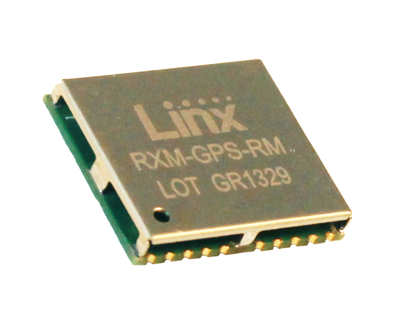
Linx Technologies announces its launch of the high-performance, low-cost RM GPS receiver modules. Using the built-in MediaTek MT3337 chipset, the RM module can simultaneously acquire on 66 channels and track on up to 22 channels, providing standard NMEA data messages through a UART interface. A simple serial command set can be used to configure optional features.
According to the company, the RM receiver module is a cost-effective GPS solution that offers no-frills, basic operation in a compact 15 x 13 millimeter package. The MediaTek MT3337-based RM Series is self-contained and only requires an antenna. It powers up and outputs position data without any software set-up or configuration, making the RM Series easy to integrate, the company said.
The receiver operates down to 3.0 volts and has a low tracking current of 12mA. The module has built-in receiver duty cycling that can be configured to periodically turn off the module for added power savings. This low-power consumption helps maximize runtimes in battery powered applications, such as consumer recreational positioning, marine, location and tracking, cargo tracking, and other asset monitoring systems.
In addition, the available GPS Master Development System connects a RM Series Evaluation Module to a prototyping board with a color display that shows coordinates, a speedometer and compass for mobile evaluation. A USB interface allows simple viewing of satellite data and Internet mapping, as well as custom software application development.
Cambridge Consultants introduces radar-based technology detection system to help agricultural vehicles avoid collisions. The new radar system helps prevent this by protecting the perimeters of the vehicle from potential hazards – giving audible and visual warnings to the driver.
“We have identified a huge demand for this type of agricultural technology as we see a continued increase in advanced farming techniques in the face of impending population growth and food shortages,” said Gary Kemp, programme director at Cambridge Consultants. “We’ve created practical technology that’s simple to operate and install but is also low cost and incredibly effective.”
According to the announcement, the radar units are designed to be installed on the front and rear of a vehicle as well as on the boom ends, and can detect multiple collision hazards in a wide field of view which maximises coverage. The technology can process many different moving and stationary obstacles – and instantly send an alert to the driver to warn of a potential collision. The low-frequency (5.8GHz) system is based on standard manufacturing principles, making it a cost-effective solution. The patented short-range radar technology provides unbeatable performance from a compact, low-cost sensor. The sensor simultaneously tracks multiple objects in 3D over a wide field of view and up to 30m range. Real-time collision prediction algorithm identifies hazards early, giving the driver ample time to take avoiding action
The company will be showcasing its latest farming technology at the Agritechnica International Exhibition, November 12-15, in Hanover, Germany, hall 17, stand C38.
When looking at geospatial technology, I like to use the analogy that GIS software is the engine and GIS data is the fuel. We have many choices of powerful GIS software engines (Esri, Intergraph, QGIS, GlobalMapper, MapInfo, etc.). That technology remains relatively unchanged. Before the software vendors harp on me, yes, I get that new bells and whistles are added to software every year to enhance software functionality. Yes, maybe there’s a new database technology that indexes massive databases significantly faster. Yes, maybe there’s a new software tool that makes generating 3D visualizations or augmented reality much easier and faster. But just like your automobile, motorcycle, train, airplane, etc., they all need fuel to run. Data is the fuel.
The analogy doesn’t fit perfectly. After fossil fuels are used once, they are not reusable. Obviously, that’s not the same for GIS data. Some GIS data, like street data, is used daily over and over again by millions of people around the world in their Garmin, TomTom, and Magellan auto navigation units. However, in the fossil-fuel world, engines and fuel are matched reasonably well. In the geospatial world, the engines and fuel aren’t matched. The GIS fuel (data) is far behind the engine (software). In other words, GIS software is starving for data. There are so many applications for GIS yet to be realized, and vast majority of the unrealized apps are due to the lack of data.
For example, imagine carrying your iPad (or other tablet) in the street and pointing it down at pavement. Imagine, on the screen of your iPad, being able to “see” all of the infrastructure underneath the pavement such as water lines, sewer lines, and communications lines. What’s keeping those types of apps from being deployed today? The answer: the lack of accurate geospatial data.
The lack of geospatial data is no more apparent than at the 2013 Esri International User Conference in July and the Intergeo conference in Germany earlier this month.
In the exhibition areas, three trends were clearly apparent:
1. Mobile devices
2. UAVs
3. High-precision GNSS receivers
Clearly, all three of these are related to collecting GIS data.
Following are some comments and photos of each trend.
Mobile Devices
A few short years ago, mobile devices suitable for GIS data collection were a specialty item, and we had a few limited choices. Ever since the smartphone explosion and Apple introducing the iPad, it’s been mobile devices galore. A tremendous number of consumer mobile devices have been introduced. Most have failed, but the trend has generated a tremendous amount of R&D effort that manufacturers have leveraged to make industrial mobile devices for the geospatial community, such as the following:
Most, if not all, of these devices are designed and manufactured in China.
Juniper Systems is one of the few remaining U.S.-based rugged handheld manufacturers, introducing the new Archer 2 at Intergeo.
UAVs
There’s no denying that UAVs are going to play a large role in geospatial applications. In some geographic regions of the world, they are already being deployed for mining, agriculture, accident reconstruction and other mapping applications. The low-cost and and quick, convenient deployment make it a very attractive technology for time-sensitive and cost-sensitive applications that require imagery.
In the U.S., it is illegal to use UAVs for commercial applications unless you have a Certificate of Authorization from the Federal Aviation Administration (FAA), which are only granted to some universities and some government agencies. President Obama ordered the FAA to generating guidelines for integrating the use of commercial UAVs into the U.S. airspace by 2015. For the latest FAA progress on matters regarding UAVs, you can visit this FAA web page.
The current FAA rules are a bit odd. In the U.S., you are allowed to fly “hobby” UAVs up to 400 feet above the ground if you’re at least 1/4 mile away from an airport. If you take that same UAV and abide by the same restrictions as hobbyists, but use it for commercial purposes, it’s illegal. Take a look at this article by NBC News.
High-Precision GNSS Receivers
I’ve been writing about this for awhile, but it’s worth mentioning that RTK GNSS receivers are getting cheaper and cheaper. Whereas in the past, there have only been a handful of RTK GNSS receiver vendors, there are now at least twice as many as before, and increasing every year. This is good for the user community because it increases competition. The result is better products at lower prices. This trend will continue.
NSPS (Formerly ACSM) Radio Hour
Last week, I was a guest along with David Doyle (retired NGS Geodesist) on the NSPS Radio Hour discussing a variety of GNSS-related items such as the U.S. federal government shutdown and LightSquared. A recording of the radio show is available in MP3 format. You can listen or download it here.
CMTINC.COM announces the release of the Utility Data Collection app for the Apple iPad. This powerful GPS/GIS mapping and data collection app was mainly designed for utility asset management and meter reading. However, it could also be used by other professionals who need to map points, lines and areas and record pertinent information for the mapped Features, such as for fish & wildlife, natural resources, land management, oil and gas, archaeology, sales route management, and others.
According to the announcement, the Utility Data Collection app provides a dedicated data entry form for entering meter readings and other observations. The meter readers can opt to have the meter route displayed on a satellite map. They will be able to tell which meters have been read as the corresponding symbols will display in a different color on the map. They will also be able to sort and search the meter records. The import and export functions makes it easy to set up meter routes, upload meter database and export meter readings.
Between the monthly meter reads, the app can be used by the maintenance crew to map the locations and record the conditions of land plots, utility poles, utility meters and other equipment. The surveyed items can be easily tagged with pre-defined descriptions as well as photos taken on the spot.
The company reports that the Utility Data Collection app is the answer for small towns and utility cooperatives who are looking to transition to a newer and more effective utility management and meter reading system on a budget.
Blue Marble Geographics announced the release of a fully managed .NET version of the GeoCalc 6.6 software development kit (SDK). Now .NET developers can get all of the accuracy and power of the GeoCalc toolkit in a fully managed .NET control. Blue Marble’s geospatial data manipulation, visualization and conversion solutions are used worldwide by thousands of GIS analysts at software, oil and gas, mining, civil engineering, surveying, and technology companies, as well as governmental and university organizations.
According to the announcement, GeoCalc is a fully object-oriented class library for software developers. Available on a number of platforms, not only does it support a massive amount of geodetic objects out of the box but the tool also has a direct connection to the OGP’s EPSG Geodetic Parameter web registry. This allows you to directly update your EPSG definitions whenever you need it and to supplement our already huge database with even more objects for coordinate transformation. Blue Marble’s geodetic toolbox leverages an XML data source, enabling secure and powerful data transformation management through interfaces and logic that allow you to lock down your datasource via password protection. The toolkit includes a variety of tools for improving data quality management from a development level allowing the software developer to work with the survey expert to provide powerful coordinate transformation software. With the release of the fully managed .NET platform, developers now can get all of the accuracy and power of the GeoCalc toolkit in a fully managed .NET control.
“This fully managed version of GeoCalc has come about from working closely with a number of our developer customers over the past year,” stated Blue Marble President Patrick Cunningham “We’re pleased to make powerful, reliable coordinate transformation available for any software environment and happy to assist our customers at the same time. When we say customer driven development, we mean it.”
The company reports that the GeoCalc fully managed SDK is built on Microsoft’s 4.0 .NET architecture. This means all of the memory management details are handled entirely by the .NET virtual machine and the CLR (Common Language Runtime). Using this standard Windows framework increases security, performance, and usability for anyone working inside the latest Microsoft development environments. This new version of GeoCalc streamlines the development process as 32 and 64 bit compatibility issues are handled entirely by Visual Studio, and the new code base means only one application needs to be delivered for both environments. The single DLL redistributable framework makes windows deployment much easier in many cases, lowering development costs and speeding up time to market.
Trimble has introduced the Trimble V10 Imaging Rover, an integrated camera system that precisely captures 360 degree digital panoramic images for visual documentation and measurement. The Trimble V10 Imaging Rover enables professionals in a broad range of industries—including survey, GIS, engineering, and oil & gas—to quickly capture rich, complete data of their surrounding environment. In the office, users can take measurements and create comprehensive deliverables using Trimble Business Center office software.
According to the announcement, the Trimble V10 with Trimble VISION technology, leverages calibrated imaging sensors allowing digital images to be captured directly from the range pole. Twelve calibrated cameras—seven panoramic and five downward-looking—integrated in the Trimble V10 provide complete site visualization and documentation with a 60 MP panoramic image that can be used to make photogrammetric measurements.
Easy to use with one button operation, the Trimble V10 enables geospatial professionals to perform work where there are many features to collect or where features are complex or difficult to capture, such as oil and gas industrial facilities, and capture increased amounts of data in less time. Trimble Access field software running on the Trimble Tablet Rugged PC offers a simple and intuitive process to capture and review images and store observations.
The solution works standalone or can be seamlessly integrated with the Trimble R10 GNSS receiver and Trimble S-series total stations such as the VX, S8 and S6 so that panoramic images can easily be captured along with high-accuracy positions for an accurate geospatial dataset. Combined with the Trimble Tablet and Trimble Access field software, the Trimble V10 collects visual documentation of the jobsite with corresponding positioning information for subsequent office measurement.
To quickly generate traditional and innovative deliverables, Trimble Business Center provides intuitive close-range photogrammetry tools to efficiently extract survey grade measurements from the Trimble V10 images. The rich image data can also be later mined to satisfy new customer requests, saving time and reducing the need for revisits to the job site.
“The Trimble V10 Imaging Rover ushers in a new era for geospatial data capture—positions from pictures,” said Phil Sawarynski, business area director of Imaging Solutions for Trimble’s Geospatial Division. “The capability to easily integrate panoramic images into traditional datasets and take measurements from those images sets a new standard for positioning applications.”