A San Juan interagency hotshot crew member refers to a map on his iPad as he coordinates execution of their burnout operation. (Photo credit: Esther Godson)
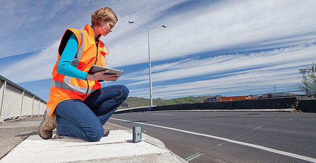
Every year thousands of acres of forests are engulfed in fires. Recognizing the benefits of geospatial technology, the United States Forest Service (USFS) Geospatial Management Office (GMO) is using Avenza System Inc.’s award-winning PDF Maps mobile app to deliver interactive digital maps to firefighters and emergency response teams situated in forests across the United States and its territories.
The USFS fights wildfires and other natural disasters in more than 155 national forests and 20 national grasslands, totaling an estimated 193 million acres or 30 percent of all federally managed lands. The USFS GMO is responsible for the implementation of the Forest Service geospatial program which includes using technologies such as GIS, remote sensing, cartography, geodesy and GPS.
The centered blue GPS position on an operations map pinpoints the user’s location. (Photo credit: Carl Beyerhelm)
With increased use of digital solutions, the USFS benefits from Avenza’s PDF Maps app geospatial technology in enabling its thousands of firefighters and support personnel. The PDF Maps app aids emergency response teams who use digital devices for work in the field.
The app provides constant access to geographic information and points of interest, with additional interactive features such as measuring, place marking and location tagging. The app operates without the risk of lost reception due to cell tower proximity and does not rely on an Internet connection to use map data. It uses GPS to obtain and display an accurate position on the ground regardless of network connectivity.
A hardcopy map is compared to its digital counterpart cached on a smartphone. (photo credit: Kari Greer)
“Accessing maps on mobile devices ensure responders have accurate and current geographic information while they’re out in the field,” said Carl Zulick, Geospatial Information Officer, USFS. “Avenza’s PDF Maps app makes it possible for teams to use any map digitally without requiring a data connection while involved in an emergency situation. Since the maps are location-aware and interactive, we can capture real-time data, photos, and locations. This data can be shared to assess the situation and make necessary strategic changes and improve situational awareness.”
The PDF Maps app is available now on the iTunes App Store and Google Play Store free of charge for personal recreational use. A Windows version is currently in public beta release. Commercial, government and academic use licensing is available for a nominal annual fee. Pricing of each map is set by the publisher and free maps remain free to users through the PDF Maps app in-app store. Commercial use licensing starts at US$49 per year and drops on a per-device basis as deployment numbers increase.
Mobile maps help air-tanker pilots avoid the mapped yellow areas, where application of aerial fire retardant is restricted. (Photo credit: Max Wahlberg)
Bruce Donaldson of Red Hen Systems LLC gave a presentation about MediaMapper Mobile, an Android app with extensive utility for ISR professionals and civilians, on a panel at the Innovative GEOINT Application Provider Program (IGAPP). IGAPP was held in St. Louis on Oct. 20. Donaldson is Red Hen’s Intelligence Surveillance and Reconnaissance (ISR) manager.
During his years of field service, Donaldson worked to address the need for Mobile Geo-Intelligence platforms that can rapidly collect, process and disseminate geospatial data and other multimedia within 24 hours of a mission.
At its essence, MediaMapper Mobile enables users to:
Geotag video, photos, audio and other notes. Annotate ground track logs. Create audio and visual notes connecting them to points of interest. Tag features from a touchscreen.
See track log (a.k.a breadcrumb trail). View on a map along with GPS details about location, including latitude, longitude, and altitude. Inspect media objects and other sensor streams. Share with others with XML and KML/KMZ.
Use with Vectronix, LTI or Trimble laser rangefinder (compass, tilt, range, calibration). Or, triangulate your location by taking two or more photos of the same object. Once the feature is identified in these images, MediaMapper Mobile will do the calculation to show you where the object was and where you were when you took the photos.
Configure settings for GPS devices, cameras, shuttering automations for intervalometry (time/distance).
Log files, manage collection projects, and complete inspection forms on site.
Transfer your raw multimedia data files and their track logs from your Android device to a laptop, tablet or server to view and analyze on Google Earth, Esri ArcGIS, FalconView or MediaMapper for desktop.
Patrol/Event Recorder with NMEA compliant record schemas compatible to MediaGeotagger and GEM2MISB for Esri ArcGIS and the free Full Motion Video module.
The Western Forestry and Conservation Association (WFCA) has announced that registration for the Fifth Annual Field Technology Conference (FTC) is open. FTC 2015 is hosted by WFCA, Pacific Northwest Aquatic Monitoring Partnership (PNAMP) and StreamNet. The conference will be held Nov. 18-19 at the Holiday Inn Convention Center in Portland, Ore.
The Field Technology Conference offers attendees an insightful look at trends in field data collection hardware (smartphones, handheld/tablet computers, GPS receivers, laser rangefinders, and other data collection instruments), remote sensing (UAVs, photogrammetry, lidar) and mapping software (data collection, data processing, map building) along with outdoor demonstrations and a field trip.
“This will be our fifth conference. With the addition of the fisheries track and participation from the Civil GPS Interface Committee, we should have a significant attendance increase this year,” said moderator/co-organizer Eric Gakstatter. “We continue to attract speakers with strong expertise in their disciplines to present their work and thought leadership.”
The conference offers three tracks:
Common field technology: Discussing field data collection technology used across all disciplines such as UAVs, GPS, and mobile devices.
In addition to the three technical tracks, there will be outdoor technology demonstrations as well as a fisheries field trip to a local slough for a live demonstration of field data collection technology (space limited).
On the second day of the two-day conference, there will be presentations from the Civil GPS Interface Service Committee (CGSIC). CGSIC is the only forum in which civilians have the opportunity to interact directly with US GPS authorities.
FTC 2014 attendees included representatives from Federal/State/Local government, Fortune 1000 companies, Native American tribes, higher education and natural resource consultancies.
The registration fee is $250 if registered by Nov. 5 and $295 if registered after that date. The government rate is $195 and $245 if registered after that date. Attendance to the CGSIC presentations on November 19 is free of charge and open to the public (lunch not included).
The registration fee includes lunch on both days as well as refreshments during breaks. The conference room rate is $99/night plus tax. After Oct. 27, the reduced rate will be subject to availability.
To register or learn more about the conference agenda, go to the conference website.
Sponsorship opportunities are available. Please contact Richard Zabel [email protected], 503/226-4562.
The PennDOT TDS developed by GeoDecisions enables collection and processing of millions of data points.
GeoDecisions, an information technology company specializing in geospatial solutions, has developed a new traffic data system (TDS) that processes more than 20 million new records per month for the Pennsylvania Department of Transportation (PennDOT).
Built on the Esri platform, the TDS helps PennDOT’s Bureau of Planning and Research better manage the download of traffic data from collection sites throughout the commonwealth of Pennsylvania.
“Built to Federal Highway Administration standards, GeoDecisions’ redesign of our TDS provides us a method to seamlessly introduce new counting devices, more efficiently verify our raw traffic data, and speed up our process for creating yearly traffic volume maps,” said Andrea Bahoric, planning division manager with PennDOT.
The new TDS improves PennDOT supervision of 45,000 short-term or portable counters that classify vehicles, record traffic volume and weight, and determine driving speed. The system’s mobile Field Operations Module (FOM) also streamlines in-pavement counter inventory and maintenance activities.
“FOM enables PennDOT field technicians to use smartphones or tablets to perform site reviews and document issues,” said Greg Ulp, senior project manager with GeoDecisions. “Convenience and efficiency are critical factors when enhancing technology and managing assets.”
PennDOT’s predecessor traffic data management system contained nine applications with dated technology requiring manual intervention to collect and verify information. GeoDecisions’ TDS redesign features five modules streamlined for better performance and usability. The new automated system includes remote user access and cutting-edge GIS mapping, web service, database and coding technologies.
“Our transportation system solutions provide a proven business model for analytics, reporting, reliability, and technology workflow management,” said Tom Saltzer, vice president of government delivery with GeoDecisions. “PennDOT’s redesigned TDS is a long-term collection, verification, and geospatial solution that reflects their ongoing enterprise GIS investment strategy.”
BYOD Sub-Meter Positioning for Mapping and GIS Professionals
Employees bringing their own mobile phones and tablets to their jobs in the field enables them to complete more tasks using fewer devices. However, this practice introduces operational and security vulnerabilities.
By Matt van Doorn
In the mapping and GIS industries, mobile devices such as smart phones and tablets have a growing presence in the field; they enable businesses to work smarter and more efficiently. The Bring Your Own Device (BYOD) trend — essentially the use of commercial-grade devices for work purposes — will likely not slow down. BYOD is not without its pain points. Organizations face many security vulnerabilities when commercial-grade devices access critical data via corporate IT networks. Additionally, there are applications where a mobile device’s location capabilities are not accurate enough for GIS professionals to efficiently and effectively locate an asset and collect data.
Company IT departments have multiple options that control and monitor access to combat BYOD security issues; however these options do not resolve the accuracy issue. Traditional company-issued handheld integrated receivers for data collection are designed to meet accuracy demands in almost any physical environment condition. While these devices are the most appropriate technology option for some applications, they tend to be expensive for the positioning tasks where a smart phone or mobile device is “good enough.”
What to do when better accuracy on a mobile device is required, but it doesn’t make sense to invest thousands of dollars in a traditional receiver? With proper research, field professionals will find professional solutions that pair with consumer-grade smart devices to produce the requisite accuracy for a fraction of the cost of a traditional receiver.
Requirements and Accuracy
At a minimum, handheld receivers destined to work in conjunction with mobile devices must meet the following requirements:
The device must have moisture ingress protection to function properly in snow, ice, rain or dust environments.
The device must survive falls in hard terrain. It should have shock, drop and vibration protection.
The device must last the full workday for the professional to complete all workflows on a single battery charge.
Legacy company-owned receivers typically meet the requirements above and have had a long-term reputation for accurately providing positioning data. These devices are still the appropriate solution for environments where it does not make sense to take a smart device, such as a remote location in rough terrain where the smart device may not perform.
However, a smart device can in many cases enable the employee to be more efficient. Thanks to the accessory market, many of the above-listed requirements can be easily addressed. For example, smart-phone juice packs can fix the battery longevity issue; cases can protect against weather, shock or dropping; and screen covers can address the sunlight screen visibility issue. With a smart device in hand, GIS and mapping professionals not only have access to GPS data, but they are able to access and complete other work-related tasks from the same device such as email, internet access and voicemail. Plus, a smart phone is only a fraction of the cost of traditional receivers.
The most critical component that smart devices still cannot address is sub-meter accuracy, which many mapping and GIS professionals require to successfully do their job.
Accuracy Drives Cost. Mapping and GIS businesses are acutely aware of the efficiencies created by greater accuracy. With poor information, errors become increasingly costly. When robust, accurate data is collected, there is a direct correlation to improved workflows and operations. This allows professionals to be more strategic in ensuring that applications are effective and efficient across operations.
Aerial and satellite imagery made initial steps toward generating more accurate data collection, bringing mapping and GIS professionals to within a 50-centimeter range of the assets. Subsequently, high-speed lidar collection tools, designed to capture large areas at 5–10 cm accuracy, came to the market. While these tools significantly improved data collection, precise measurement typically requires more time, more expense and highly specific instruments in order to generate more data.
Today, handheld receivers can achieve high accuracy without using survey-grade tools, in applications that include:
Mapping: Any application, including locations, quantities, densities, specific areas and map change.
Aquatic monitoring
Buried utility infrastructure/cable location
Water/wastewater disposal
Location and elevation measurements: for example, elevation data on manholes or trunk lines.
Requirements vary across applications and industries. The mapping/GIS professional must determine the level of accuracy their workflow requires.
Accuracy Evaluation
A typical smart device, properly assisted, can achieve an accuracy range of up to 5–6 meters when used to locate an asset. In many cases this is good enough. To obtain positioning data, iOS devices use the application “Location Services,” which is available on multiple mobile platforms. Location Services enables location-based apps and other applications to use information from GPS and cellular and Wi-Fi networks to determine location information. The location provided by a hybrid system with cellular-assisted GPS (A-GPS) allows the device to identify location within a 5–6 meter range of an asset. Wi-Fi positioning alone can determine a location with an accuracy of about 74 meters, and cellular positioning alone offers about a 600-meter range for location, according to industry sources (www.windowscentral.com/gps-vs-agps-quick-tutorial).
However, cellular positioning can be limited when there is no network available. In remote or industrial settings, this could create difficulties in asset location. In water/wastewater, for example, when a GIS professional is in a ditch looking for a valve or a meter and there isn’t a network connection, the accuracy level provided without GPS may not be sufficient for that application. When A-GPS is not available due to a lack of cellular network, GIS professionals also have to deal with convergence time.
Another example involves searching for a manhole cover when the ground is covered by a couple feet of snow. In this case, the 5-6 meter range is quite large and could lead to a lot of time spent digging until the manhole is uncovered. This wastes time and energy, and leads to higher costs. Some receivers have the sub-meter capability and can provide the location data directly to the professional’s consumer-grade smart device through Bluetooth. By simply pairing the receiver with a cellphone, the GIS professional can quickly locate the asset, collect data and move on to the next task.
Accuracy Solutions
Location shortcomings in consumer-grade devices generally boil down to antenna performance. Consumer-grade smart devices are designed for exactly that: consumers. With antennas for Wi-Fi, Bluetooth and GPS built into the small device, there will be compromises in location accuracy. When location must be pinpointed, an integrated handheld receiver can enhance accuracy. Receivers are readily available with 12 channels parallel tracking. Some receivers can also support multiple satellite constellations, including GPS, GLONASS, Galileo, Beidou, and QZSS with up to 44 channels of parallel tracking. The accuracy of these devices is further supported by augmentation: WAAS, EGNOS, MSAS and GAGAN. These receivers can provide sub-meter accuracy, with asset location with as close as 60 centimeters. Some devices also support Virtual Reference Stations (VRS) and Trimble’s Real Time eXtended (RTX) correction service for sub-meter accuracy. Some RTX services achieve real-time sub-meter accuracy with IP and cellular connectivity, or over satellite L-band.
A receiver that integrates with the workflows of various mapping and GIS softwares as well as third-party applications will pair up nicely with a mobile device. The computations are all done for the professional, and will transmit signals via Bluetooth into the host devices using NMEA protocol. On iOS and Android devices, the location is available through the Location Services API. Third-party applications are also able to work with the receiver through consumer-grade devices that utilize the location services API. Some receivers are available across operating systems including iOS, Android and Windows, and are available to upgrade to the latest smart device whenever needed.
Important Device Attributes
Receivers designed to be compatible with a variety of smart devices can be shared among multiple devices. When it is time for a smart device upgrade, the new device can easily integrate with the receiver. Additional features that make these receivers especially convenient to use in the field include:
Small size: Mapping and GIS professionals don’t always have an extra hand available to carry an extra device. If it can fit in a vest, jacket pocket, pouch, clipped onto a belt, or pole mounted it will function in many scenarios.
Lightweight.
Rugged: Some receivers comply with MIL-STD-810 ruggedness with IP65 rating for shock, drop and vibration.
Battery life: for field performance for a full work day.
External antenna port: An accessory port for external data if the collecor needs to be mounted on top of a vehicle, or in a hard hat situation; a bonus feature worth consideration.
BYOD Trend and Limitations
The smart-device market will not cool down anytime soon. Gartner Research predicts that in 2015, almost 2.3 billion devices will be shipped worldwide. Whether these smart devices are provided by the company or truly BYOD, they will need to be augmented to effectively serve the applications they are intended to support. Solving the security issue can have a bearing on whether a company chooses to let employees use their own device or provide one; either way, enhancing the location capabilities of the device can be easily achieved with accurate receivers.
Matt van Doorn is a product management, product marketing, market management and business development professional at Trimble Navigation. He has years of experience in the data communication and telecommunication industry with deep knowledge of international markets.
Hexagon Geospatial has introduced an early access program for technologies associated with the Hexagon Smart M.App experience. The two applications available in the early access program are M.App Chest and GeoApp.UAS.
M.App Chest provides a simple means to quickly upload, organize, and share imagery and point cloud data in the cloud. M.App Chest also provides optional compression capabilities along with streaming and delivery via web services.
“M.App Chest provides a better experience to easily upload, store and share geospatial data,” said Mladen Stojic, President of Hexagon Geospatial. “M.App Chest can standalone or compliment other Hexagon Smart M.Apps, providing a simple, cloud-based environment for managing imagery and point clouds.”
GeoApp.UAS was built by Hexagon Geospatial’s partner, Geosystems GmbH. GeoApp.UAS enables rapid processing of UAS data at the speed it is captured. With an intuitive workflow, GeoApp.UAS enables robust photogrammetric processing of UAS data on the cloud.
Interested individuals can register for the opportunity to participate in the early access program on the M.App Chest or GeoApp.UAS product pages. Hexagon Smart M.Apps will be launched at HxGN LIVE Hong Kong in November 2015.
The United States Geological Survey (USGS) continues to support the delivery of its digital maps through Avenza Systems Inc.‘s PDF Maps app. It has widened the selection to more than 120,000 US Topo topographic maps on its digital mapping platform, which provides digital users access to USGS’ rich map content and extends its reach with a growing base of mobile consumers.
The app currently aids a growing number of people who reference digital devices for work or recreation. Travelers, scientists and conservation and environmental decision makers already make use of USGS topo maps, but the expanded use of the maps via the PDF Maps app provides current USGS topo map users the ability to digitally access maps in areas with little to no internet reception and input notes and images within the map all while tracking current position.
The USGS produces US Topo maps on a continuous basis with more than 18,000 revised quadrangles produced every year. Currently, thousands of maps from USGS’s extensive library are now available in Avenza’s PDF Maps database, including the most current variations that reflect the changing landscape of the country.
Many historical maps can also be accessed, with thousands more dating back 130 years being added in the near future, according to Avenza. The app provides constant access to geographic information and points of interest, with additional interactive features such as measuring, place marking and location tagging. Avenza’s PDF Maps app operates without the risk of lost reception due to cell tower proximity, making it the ultimate traveling tool since it does not rely on an internet connection to use map data and obtain and display location.
“Distinguished map publishers like the USGS fully recognize the shift to digital and how consumers are accessing and consuming information that was once static and digitally implementing it into their daily lives and making it more interactive,” said Ted Florence, president of Avenza Systems Inc. “Avenza’s PDF Maps app is an example of how a digital tool can expand the utility of a map beyond location guidance; it is also a tool to capture an experience in real-time. As the industry continues to evolve to fit into the world of a mobile consumer, we look forward to strengthening our ties with groups like the USGS.
PDF Maps app 2.6 is available on the iTunes App Store free of charge for personal and private use. PDF Maps app is also available for use with Android devices in the Google Play Store free of charge for personal non-commercial use. A Windows version is currently in public beta targeted for a release later this year.
Spectra Precision introduced at INTERGEO this week new and enhanced products in its portfolio of survey solutions. With the new additions, survey and construction professionals have more positioning instrument choices to meet their job requirements, the company said.
Spectra Precision made the announcement at INTERGEO 2015, the world’s largest conference on geodesy, geoinformatics and land management.
The new and enhanced products include:
Spectra Precision FOCUS 35 RX – A new range of motorized total stations providing high-speed, accuracy and precision in measurement. The FOCUS 35 RX robotic instrument moves the power of the observer from the instrument to the range pole, improving efficiency. The speed of observation and precise positioning of the FOCUS 35 RX Robotic Total Station is provided by patented StepDrive motion technology, which controls the horizontal and vertical motion of the motors, eliminating the need for traditional motion locks. The FOCUS 35 RX includes a tracking sensor that uses LockNGo FastTrack tracking technology, enabling the instrument to constantly lock onto the prism.
The FOCUS 35 RX is available in 2”, 3” or 5” accuracies, features market leading extended operating time with its dual battery system and is controlled externally by Spectra Precision Ranger, Nomad, or T41 data collectors running Spectra Precision Survey Pro or Spectra Precision Layout Pro field software on the Ranger or Nomad.
“The streamlined design, extremely light weight, very quick turning speed and exceptional battery life enhance the overall value-proposition of the FOCUS 35 RX and make this instrument a very compelling choice for a wide range of survey and construction applications,” said Olivier Casabianca, Spectra Precision Business Area Director. “With the introduction of the FOCUS 35 RX, Spectra Precision continues to expand and improve its portfolio with powerful solutions using new technologies.”
Spectra Precision Nomad 1050 Data Collector — The Nomad 900 has been updated with new features and capabilities. The Nomad 1050 has more RAM, more Flash and more speed. The base processor is now 1 GHz compared to 806 MHz on Nomad 900 and the Nomad 1050 has 512-MB RAM and 8GB flash storage. The other major enhancement is a new 3.75-G dual-mode GSM and CDMA WWAN modem to provide fast and versatile connectivity for Spectra Precision customers. Also, the new WWAN module uses an internal antenna eliminating the need for an external antenna.
Spectra Precision Survey Pro 5.7 Field Software — Constant improvement and enhancement continues with Survey Pro. Survey Pro version 5.7 contains significant changes to enable more productive field data collection. Included in this update are new map displays that enable viewing and managing most of the map features that are located on the main map display. The GNSS and robotic staking screens can also display a map view to include background maps along with the standard dynamic guidance control option. The GNSS offsets routine has been updated and now includes a distance-distance option. For those customers who wish to use GNSS and robotic simultaneously, there are now enhanced options for configuration and switching between modes.
Spectra Precision Survey Office v3.60 Software — Spectra Precision Survey Office now includes enhanced functionality; support for the Spectra Precision FOCUS DL-15 Digital Level and the import of leveling data from any DiNi level; least squares and 5 and 7 parameter Helmert transformations with reports; Geoid 12B support and grouping by country in the Coordinate System Manager; Point Cloud support plus many more additional enhancements.
Spectra Precision MobileMapper Field GIS Application for Android Devices — A new version of the popular MobileMapper Field GIS application now running on Android devices. This new software is dedicated to GIS data collection and focuses on simplicity to maximize the number of field personnel contributing to the geospatial business. Primarily for MobileMapper 300 users, the application will be the key component of Spectra Precision’s Bring Your Own Device (BYOD) solution. This makes it possible to pair Android tablets and/or smart phones with the MobileMapper 300 GNSS receiver to collect GIS data with survey-grade accuracy.
“With the introduction of these new and enhanced products into the Spectra Precision portfolio, survey and construction professionals have a wider range of economical choices to get the job done,” said Olivier Casabianca. “These new Spectra Precision optical products complement the ground-breaking line of Spectra Precision solutions, enabling Spectra Precision to offer a complete range of survey products.”
Trimble debuted its new R2 GNSS receiver at INTERGEO 2015, held this week in Stuttgart, Germany.
The R2 GNSS receiver is a receiver that works with Trimble handheld devices and iOS, Android or Window mobile handhelds, smartphones and tablets using Bluetooth or USB connectivity. When paired with a mobile device, the receiver adds professional-grade GNSS capabilities for better accuracy. The rugged Trimble R2 provides GIS and survey professionals the flexibility to choose the mobile device, workflows and accuracy they need based on applications.
Trimble R2 GNSS Receiver for Mobile Devices
The Trimble R2 GNSS receiver is compact and portable, weighing 2.4 pounds. With one button operation and field swappable battery, the receiver can be pole or vehicle mounted or carried on a backpack. The R2 is a multi-constellation receiver that supports GPS, GLONASS, Galileo, BeiDou and QZSS satellite signals as well as SBAS.
With a variety of standard and optional correction capabilities, the Trimble R2 can achieve sub-meter to centimeter positioning for a broad range of accuracy requirements. The receiver is an option for the Bring Your Own Device (BYOD) strategy.
“Today’s geospatial professionals require flexible solutions which allow for configuration to meet their specific job requirements,” said Ron Bisio, general manager of Trimble’s Surveying and Geospatial Division. “The Trimble R2’s versatility to support GIS and survey workflows as well as BYOD deployment enables geospatial professionals to collect data using the mobile device, workflow and accuracy they choose.”
Workflows – GIS and Survey Field Software
Designed for both GIS field data collection and survey workflows, the Trimble R2 receiver integrates with Trimble TerraFlex mapping and GIS field software and Trimble Access survey field software.
TerraFlex software is a scalable cloud-based solution for geospatial data collection. By pairing the R2 with a smart device or Trimble handheld running TerraFlex, the solution addresses a wide variety of field requirements, including attribute-rich GIS data collection on consumer and professional devices.
Trimble Access software supports the workflows of everyday surveying tasks such as topographic and control surveys and specialized surveying tasks such as roads, monitoring, tunnels and mines. By pairing the receiver with a Trimble handheld running Trimble Access or TerraFlex field software, the Trimble R2 is a versatile solution that supports the full range of geospatial data collection workflows for both GIS and survey applications.
Flexible Accuracy
It us capable of receiving a broad range of corrections from traditional RTK, VRS networks and SBAS to Trimble RTX correction services via cellular/IP connections or satellite (L-band), the Trimble R2 provides high-accuracy data worldwide.
The R2 GNSS receiver can leverage the entire portfolio of subscription-based Trimble RTX correction services to accommodate a wide range of applications and accuracy requirements. This includes CenterPoint RTX (less than 4 centimeters), RangePoint RTX (less than 50 centimeters), and ViewPoint RTX (less than 1 meter) correction services.
Trimble debuted its new R2 GNSS receiver at Intergeo 2015, held this week in Stuttgart, Germany.
The R2 GNSS receiver is a receiver that works with Trimble handheld devices and iOS, Android or Window mobile handhelds, smartphones and tablets using Bluetooth or USB connectivity. When paired with a mobile device, the receiver adds professional-grade GNSS capabilities for better accuracy. The rugged Trimble R2 provides GIS and survey professionals the flexibility to choose the mobile device, workflows and accuracy they need based on applications.
Trimble R2 GNSS Receiver for Mobile Devices
The Trimble R2 GNSS receiver is compact and portable, weighing 2.4 pounds. With one-button operation and a field swappable battery, the receiver can be pole or vehicle mounted or carried on a backpack. The R2 is a multi-constellation receiver that supports GPS, GLONASS, Galileo, BeiDou and QZSS satellite signals, as well as SBAS.
With a variety of standard and optional correction capabilities, the Trimble R2 can achieve sub-meter to centimeter positioning for a broad range of accuracy requirements. The receiver is an option for the Bring Your Own Device (BYOD) strategy.
“Today’s geospatial professionals require flexible solutions which allow for configuration to meet their specific job requirements,” said Ron Bisio, general manager of Trimble’s Surveying and Geospatial Division. “The Trimble R2’s versatility to support GIS and survey workflows as well as BYOD deployment enables geospatial professionals to collect data using the mobile device, workflow and accuracy they choose.”
Workflows – GIS and Survey Field Software
Designed for both GIS field data collection and survey workflows, the Trimble R2 receiver integrates with Trimble TerraFlex mapping and GIS field software and Trimble Access survey field software.
TerraFlex software is a scalable cloud-based solution for geospatial data collection. By pairing the R2 with a smart device or Trimble handheld running TerraFlex, the solution addresses a wide variety of field requirements, including attribute-rich GIS data collection on consumer and professional devices.
Trimble Access software supports the workflows of everyday surveying tasks such as topographic and control surveys and specialized surveying tasks such as roads, monitoring, tunnels and mines. By pairing the receiver with a Trimble handheld running Trimble Access or TerraFlex field software, the Trimble R2 is a versatile solution that supports the full range of geospatial data collection workflows for both GIS and survey applications.
Flexible Accuracy
The receiver is capable of receiving a broad range of corrections from traditional RTK, VRS networks and SBAS to Trimble RTX correction services via cellular/IP connections or satellite (L-band), the Trimble R2 provides high-accuracy data worldwide.
The R2 GNSS receiver can leverage the entire portfolio of subscription-based Trimble RTX correction services to accommodate a wide range of applications and accuracy requirements. This includes CenterPoint RTX (less than 4 centimeters), RangePoint RTX (less than 50 centimeters), and ViewPoint RTX (less than 1 meter) correction services.
The latest solutions by Teledyne Optech for the productive and accurate collection of spatial data will be on display at INTERGEO 2015, taking place Sept. 15-17 in Stuttgart, Germany — including a new solution for survey-grade mobile mapping.
At booth C4.019 in Hall 4, Teledyne Optech will present the latest addition to its high-powered Optech Lynx mobile survey systems. The new model is designed for both efficient asset collection and the delivery of engineering survey-grade results, giving operators flexibility for multiple types of jobs. Teledyne Optech will also demonstrate how the advanced features of Optech LMS 3.0 improve collection and processing efficiency by enabling access to survey control.
Several other Teledyne Optech systems will be at the booth, including the Optech Galaxy airborne mapper. Visitors can take the opportunity to see how Galaxy vastly improves survey efficiency and consistency in variable terrain by letting surveyors ignore multipulse blind zones and keep their swath and point density on the ground constant with its PulseTRAK and SwathTRAK technologies. Forestry and coastal data from the Optech Titan will also be available, with Teledyne Optech experts ready to explain the new techniques that surveyors, government agencies and academics have developed to take advantage of its revolutionary multispectral lidar technology for topo/bathy surveys, land classification and biomass estimation.
The CZMIL Nova System is designed for airborne coastal and marine mapping.
Groups interested in surveying deeper in turbid waters than any other airborne lidar can also drop by the booth to hear more about the Optech CZMIL Nova. Even smaller organizations with limited budgets can now make use of CZMIL Nova, thanks to redesigned hardware that lets it survey from aircraft as small as a Piper Navajo, plus the ability to rent the sensor and its HydroFusion workflow through the CZMIL Project Program.
For smaller scale projects, Teledyne Optech will display integrated solutions using the flexible Optech ILRIS terrestrial lidar scanner: Users can rapidly survey open pit mines by combining ILRIS with photogrammetry from the new geo-XR6 UAV, constantly monitor dangerous areas for landslides with the Gexcel OPMMS solution, or even survey harbors above and below water simultaneously with an integrated ILRIS/Seabat sonar system.
Visitors interested in improving productivity and safety in underground mining can see the Optech Cavity Monitoring System (CMS) V500 in action and try out its new integrated camera, georeferencing tools and more.
Esri revealed the winners of its Storytelling with Maps Contest at the Esri User Conference, highlighting grand prize winner Joyce John’s Snow Journal story map for the City of Boston. John’s story map incorporated data-rich maps, videos, photos, and text to craft an engaging story of how the city dealt with historic amounts of snow in Boston earlier this year.
As the grand prize winner, John, a member of the City of Boston’s GIS team, will receive a one-year ArcGIS Online subscription for five users plus a plaque and certificate.
“Story maps harness the power of geography to tell stories in the most engaging ways,” said Allen Carroll, program manager, storytelling. “The winners of our Storytelling with Maps Contest demonstrate the endless ways people can use this rich medium to share their stories with the world.”
Storytellers from around the world submitted more than 400 entries that covered the full gamut of Esri Story Map templates. Contest judges selected the following 18 story maps as winners from across the five contest categories:
Best Travel, Destinations, and Recreation
First Place: Elizabeth Frank for Living on the Edge: The Extremes of Human Inhabitance
Second Place: GIS Team, County of Simcoe (Ontario, Canada), for Matchedash Bay Loop Trail
Third Place: Daragh McDonough, Donegal County Council, for The Hills of Donegal, Ireland
Honorable Mention: Yasser Ayad, Clarion University of Pennsylvania, for Al Qahira: A Trip to the Past
Best Infrastructure, Planning, and Government
First Place and Grand Prize: Joyce John, City of Boston, for Snow Journal
Second Place: Alberto Fiorillo, VeloLove/Legambiente, for GRAB: Grande Raccordo Anulare delle Bici
Third Place: Pat Landrum, San Diego Association of Governments (SANDAG), for LOSSAN: Coastal Rail Corridor
First Place: Emily Wilson and Chester Arnold, University of Connecticut, for Connecticut’s Changing Landscape
Second Place: Garry Simmons, Wilmington Grammar School for Girls (UK), for Journey into Danakil: Hottest Place on Earth
Third Place: Anna Mölter, Colorado State University, for Pittsburgh—Health Impact of Black Carbon Air Pollution
Best Culture, History, and Events
First Place: Chris Ingram, Santa Clara County Fire Department, for The San Francisco 1906 Earthquake and Fire
Second Place: Mark Gallant, EntertainMaps.com, for Ottawa’s Eyewitness: Thomas Burrowes
Third Place: Gordon Campbell, COGS/NSCC, for Pilot Francis Mackey and the Halifax Explosion
Best Conservation, Environment, and Sustainability
First Place: Greenbelt Land Trust and FLO Analytics for Bald Hill Farm: A Legacy for Corvallis, Oregon
Second Place: Dan Kelly and Sylvia Busby, The Nature Conservancy, for Ogooué: Field Notes from Gabon’s Great River
Third Place: Thomas Skowronski, National Rural Electric Cooperative Association, for Cooperative Solar: Driven by Cooperative Principles
Honorable Mention: Lindsay Withers and Carolyn Ives, The Trust for Public Land, O’ahu Projects
Submissions were judged on a range of factors. Each selected story map combined design, user experience, impact, and overall creativity with an interesting and engaging story.
All first-place winners will receive a GoPro camera. Second- and third-place winners will receive a copy of the Esri Press book Cartographica Extraordinaire: The Historical Map Transformed. All winners will also receive a plaque and a certificate in honor of their award-winning story maps.


 The
The