A point cloud is fundamentally a simple construct. It is a collection of points in 3D space, each point being given a coordinate in Cartesian convention. The points can also be given other properties, often these will be indicative of how they were obtained.
Examples might include the time at which they were “seen” by the surveying device that collected the data. The intensity or error in position that the point has might also be included.
Often point clouds will have around 100 million points after conducting a survey. Photography can also be overlaid on point clouds using photogrammetry techniques to essentially build 3D photography.
Image: OxTS
INS survey: point clouds
The principal method of collecting point-cloud data is by using lidar. Lidar technology is akin to radar: light is sent out from the device and bounces back off of objects. The difference is that radio uses large wavelength radio waves and lidar uses small wavelength lasers for high precision.
The time for light to return to the device is used with the speed of light to calculate the distance away. Typically, a lidar device will contain lasers with a fixed vertical angle, but which spin around in the horizontal plane. Internally, the device knows at what angle the laser is pointing vertically and its azimuth angle. This gives the device the position of the point on the object in 3D spherical coordinates.
The lasers inside produce thousands of points per second. Intensity, mentioned above, refers to the intensity of the reflected beam and indicates the reflectivity of the object.
What is a georeferenced point cloud?
Lidar requires navigation data to conduct a survey. We combine the navigation data with the lidar data to create georeferenced point clouds. Lidar devices know where points are in relation to each other, but they need to be told where they are in the world to be able to build a point cloud while moving the lidar.
The navigation data often comes from an inertial navigation system (INS). An INS is a sophisticated combiner of inertial measurement unit (IMU) and GNSS data to get the best navigation data — so a device knows where it is in the world and how it is moving.
The coordinates from the INS are added vectorially to the point coordinates of the lidar to get the final coordinates that would be used in the point cloud. This allows a user to put their lidar device on a vehicle like a van or an unmanned aerial vehicle (UAV) with an INS, to survey large areas efficiently instead of doing multiple static surveys and stitching them together.
Photo: OxTS
What are point clouds used for?
There are a wide range of applications for which point clouds can be used. They are increasingly used in real time for robots and autonomous driving computers to understand their environment and navigate through it. The data in a point clouds is convenient for recognizing and identifying surfaces and objects; for example, other cars, road signs and lane markings.
OxTS has been a global leader in inertial and GNSS technologies since 1998. OxTS is fundamentally involved in helping car manufacturers get the navigation data they require to go with lidar data in autonomous vehicle development, and in point clouds creation for use in surveying.
Distances and volumes are easy to calculate using point-cloud analysis software, and intensity can help identify different materials.
Another feature that lidar offers is multi-returns. This allows a laser pulse (which has a finite cross-section) to bounce back off of multiple surfaces to give multiple points from the same pulse. This is particularly useful for seeing windows and also seeing through them, and also for a myriad of other uses such as seeing the top of a treeline and the ground when flying over with a UAV.
It can also be used to see snow depth. The lidar can see the top layer of snow and also gets another strong return from the ground beneath.
At OxTS, we see lidar point clouds being used for driverless-car and work-vehicle development, coastal and forest management, infrastructure monitoring (signs, drains, bridges, road surfaces, railroads, etc.), creating 3D models of cities, pipeline exploration and more.
The final product is a simple file format, for which the possibilities are almost endless — and we see new applications using point clouds all the time.
“We cannot have GPS signals be a single point of failure for transportation and other critical infrastructure sectors. More safety applications will depend on PNT in the future. Public confidence in these will be critical.
“People will not be comfortable getting into an automated vehicle or with platooning driverless trucks heading down the highway if they think that their invisible hand is not reliable and that their GPS might be spoofed.
“Getting public adoption of other PNT capabilities — space-based, terrestrial, and self-contained — integrated with GPS technology will be critical to the success of any such system.”
— Diana Furchtgott-Roth, Deputy Assistant Secretary for Research and Technology, U.S. Department of Transportation, Nov. 20, 2019, Edinburgh, U.K.
A Single Point of Failure
The Department of Transportation (DOT) is responsible for leading civil positioning, navigation, and timing (PNT) issues for the United States. At the moment, the U.S. GPS provides the vast majority of PNT services in the U.S. and around the world. Yet, like all space-based systems, its signals are weak and very vulnerable to interference.
A recent example of how dangerous that can be in automated transportation systems was revealed recently in an accident report released by the British government. Interference from an unknown source caused a 15.5 kg drone to get away from its operator and crash. Fortunately, no one was hurt. The report cited analysis showing that such a weight could have easily killed someone on the ground.
Even more concerning, GPS signal characteristics are well known and therefore easy to imitate. Thousands of cases of “spoofing” have been documented with government and malicious actors causing receivers to report they are far from their actual location. In the worst cases, this can cause accidents or enable criminal acts.
One result of all of this is the President of the United States issuing an Executive Order encouraging “responsible use” of PNT systems. It also directs steps to encourage development and adoption of alternative systems. This includes a White House-level plan for research and development of non-Global Navigation Satellite System (GNSS) PNT.
In Europe the European Union (EU) has warned that space based PNT alone is insufficient for “…critical applications requiring continuous availability and fail-safe operations.” The EU has also established a monitoring system to detect sources of GNSS interference, and the European Space Agency (ESA) has established an on-going program funding study of both space and terrestrial alternate PNT systems.
Multiple Cooperating Systems
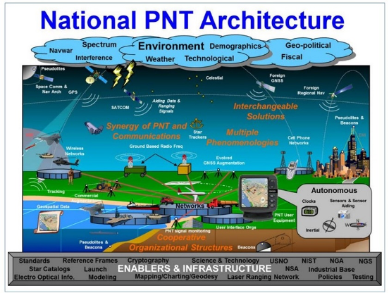
The ultimate solution, though, according to senior government officials, will be development and use of many diverse PNT systems working together to ensure users have what they need when and where they need it.
Image: DOT
The National PNT Architecture, jointly developed by the US departments of Defense and Transportation, envisions a multitude of PNT sources ranging from GNSS provided by national governments, to inertial and clock suites acquired by users as needed.
“Many people are fond of talking about a GPS backup,” said one administration official.
“It’s more appropriate to use the plural ‘backups’ since one system isn’t going to meet everyone’s needs. Even GPS doesn’t meet everyone’s needs which is why we require complementary PNT capabilities.”
The idea that multiple redundancies are required for an essential function as long been a core principle of systems engineering. This is clearly foundational in the National PNT Architecture.
It is also a feature in more recent documents.
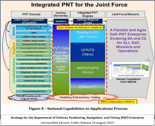
One example is the U.S. Department of Defense’s (DoD) PNT strategy publicly released in August of last year. It envisions use of a multitude of systems as a way of “Ensuring a U.S. Military PNT Advantage.”
Image: DOD
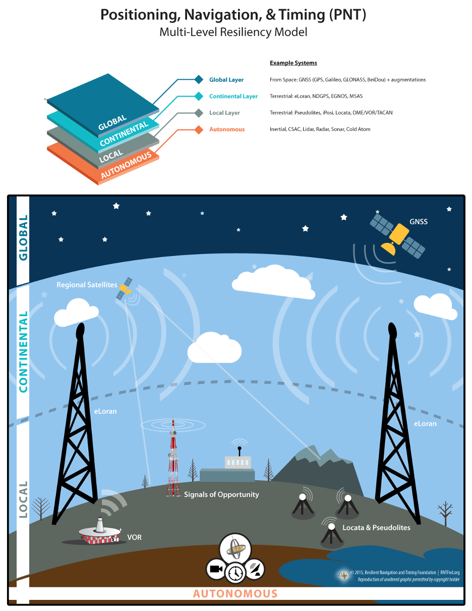
It categorizes these in three layers. A global layer of GNSS and other satellites, a regional layer that includes STOIC and eLoran, and a local/autonomous layer populated by inertial, clock, lidar, radar, scene matching and beacon-based systems.
Another project taking the architecture approach is described in detail by the recently completed MarRINav report. Sponsored by the European Space Agency, it analyzed the PNT needs of maritime commerce in the United Kingdom.
The project concluded that a “hybrid approach” using GNSS, eLoran, and the short-range R-mode VDES would be the best and least expensive combination for maritime. It also recommended a local navigation system such as Locata for port cargo operations. The study found that such a combination of systems would also benefit other transportation and infrastructure sectors.
Implementation
Yet identifying solutions is often much easier than making them happen. Especially for national projects with dozens of stakeholders. Stakeholders who may often have competing interests. And there is always the question of “Who pays?”
In the United States both the Congress and the executive branch of the U.S. government are addressing these issues, and in potentially complementary ways.
Congressional Mandates. With GPS as the cornerstone, both the DoD strategy and the National PNT Architecture show the need for one or more complementary systems to “overcome PNT capability gaps, predominantly resulting from the limitations of GPS.”
According to one senior official close to the issue, these systems need to be, “integrated with GPS and each other” and within the U.S. “serve all parts of the country — urban, rural, wilderness — even coastal maritime areas.” The idea being that they will constantly reinforcing GPS services while also serving as a safety net for users when during GPS disruptions.
The National Timing Resilience and Security Act of 2018 requires DoT to begin filling this layer in the National Architecture by the end of this year. The law, passage of which was overwhelmingly supported by both parties, mandates the department establish a difficult to disrupt, wide area, terrestrial timing system to backup (and complement) GPS timing signals. The system also must be expandable to provide navigation services. Even as a timing service, though, it has the potential to make navigation more reliable. Studies have shown that combining such a timing signal with GPS and other GNSS signals can dramatically decrease users’ vulnerability to jamming and spoofing.
The law also enables the system or systems to be established by leveraging commercial entities and expertise through cooperative agreements, public-private partnerships, and similar arrangements. These tend to be the most expeditious and least costly methods for putting such services in place. As such, they are expected to be very attractive to government program and contracting officials.
On military side, the in-process National Defense Authorization Act for 2021 requires DoD to quickly complete this part of their architecture also. Hinting that the department has failed to respond to combatant commanders “Joint Urgent Operational Needs,” it directs DoD to provide warfighters non-GPS PNT by 2023. It also directs the department to “enable civilian and commercial adoption of [these] technologies and capabilities”.
Presidential Order. The administration’s approach is outlined in a February 2020 presidential Executive Order. The order focuses on commercial entities that contract with the government, critical infrastructure, and research and development.
It calls for, within the next 24 months, agencies to “develop contractual language for inclusion … n the requirements for Federal contracts … with the goal of encouraging the private sector to use additional PNT services and develop new robust and secure PNT services.” The hope is that these new services will be adopted beyond just those companies who routinely serve government needs.
The departments of Energy, Transportation, and Homeland Security are also required to publish plans on how they will engage various critical infrastructure sectors to evaluate the degree of responsible use of PNT by each.
Also, the White House Office of Science and Technology Policy (OSTP) is tasked to “coordinate the development of a national plan… for the R&D and pilot testing of additional, robust, and secure PNT services that are not dependent on global navigation satellite systems (GNSS).” OSTP has already begun this and is seeking input from the public.
Competition and Many Players
Because PNT user needs are so varied and nuanced, most industry observers see growing opportunities for existing and potentially new providers.
“Systems and equipment that improve GNSS services, or that complement and augment GNSS are likely to find ready markets,” said Andrew Bach, a consultant on financial and other PNT issues. “User demands and needs are only going to become more sophisticated as their economic exposure increases.”
Congressional and administration focus on alternative PNT should enhance and multiply such opportunities. So, while there may be no silver bullet for solving national PNT concerns, the need for a robust and resilient architecture of PNT systems will likely mean abundant opportunities for providers.
When I was a kid in the 1960s, I was entranced by the vision of the future. Decades later, we’re here, with personal jetpacks nowhere in sight. What gives?
Photo: Photo: ridvan_celik/E+/Getty Images
When I was a kid in the 1960s, I was entranced by the vision of the future offered by science fiction books, movies, television shows and comics. Advances in technology would deliver us so many wonders — flying cars, hoverboards, robot servants. Disneyland was in on it, with an entire section of the park named Tomorrowland and its now-quaint “Carousel of Progress” attraction.
But the coolest thing would be that jetpack. You could slap it on your back and take off into the atmosphere, traveling wherever you wished like a bird. Certainly by the distant year 2020, we would all be jetting around the atmosphere from place to place.
(It didn’t occur to me that would mean strapping an actual jet engine to my body, along with highly flammable jet fuel. Where’s the fun in that?)
Decades later, we’ve all arrived in the “future,” with personal jetpacks nowhere in sight. What gives?
Then again, what I didn’t imagine in our future was a system that could pinpoint my exact location anywhere on the globe, estimate my time of arrival, and tell me about the traffic up ahead.
Back in the 1960s, that was seriously science fiction. Nor did we accurately predict the effect that capability would have on our daily lives. GPS along with internet-capable smartphones have thrust us into the Information Age.
The internet is a promise delivered, in its own way. Having a repository for all of the world’s information was another future concept, but usually envisioned with a giant worldwide computer that eventually turned on its makers.
As for flying cars, we are gradually getting there. Drone technology, supported by GNSS technology for its navigation, has led to unmanned craft and is heading toward vehicles capable of transporting people. We just need to be a little more patient.
In the spirit of looking back and ahead, check out our 30th Anniversary Supplement, which arrived with this issue. In it, experts from across the industry share memories and thoughts, and gaze into their crystal balls to predict the future of GNSS.
The White House Office of Science and Technology Policy is asking for ideas on what technology to research to protect GPS. The research and development dollars are earmarked for projects that minimize or eliminate disruption to critical infrastructure from intentional and unintentional interference.
The office is seeking input “from all interested parties on the development of a National Research and Development Plan for Positioning, Navigation, and Timing (PNT) Resilience.
“The plan will focus on the research and development (R&D) and pilot testing needed to develop additional PNT systems and services that are resilient to interference and manipulation and that are not dependent upon global navigation satellite systems (GNSS).
“The plan will also include approaches to integrate and use multiple PNT services for enhancing resilience,” the RFI states.
The effort is specifically headed by the Subcommittee on Resilience Science and Technology (SRST.) “The input received on these topics will assist the subcommittee in developing recommendations for prioritization of R&D activities,” the RFI states.
Deadline for comments is 11:59 pm ET on Sept. 9.
Responses should be submitted via email to [email protected] — include “RFI Response: PNT Resilience” in the subject line of the message.
By David Zilkoski, contributing editor, survey scene
David B. Zilkoski
I attended The Ohio State University (OSU) to obtain my graduate degree in Geodetic Science in 1979. Therefore, I will admit that I am a little biased — once a geodesist, always a geodesist. The basic definition of geodesy is the applied science for determining the size and shape of the Earth, designing and realizing reference frames, and determining where you (and anything else) is on the Earth.
In OSU’s geodesy heyday (1960–1990s), many Americans trained were sent by federal agencies: National Geospatial-Intelligence Agency (NGA), NOAA/National Geodetic Survey (NGS), USGS, Army, Navy and Air Force. During the 1970s, NGS was sending two employees back to school every year. These agencies needed geodesists because they were undertaking major projects such as NGS’ to readjust the U.S. national horizontal (NAD83) and vertical geodetic (NAVD88) networks.
I was one of the employees that NGS sent to OSU to be trained to support the NAD83 and NAVD88.
The advancements in satellites and computers have enabled geodesy to expand into many different disciplines. Geodetic science and technology now underpin many sciences, large areas of engineering (such as driverless vehicles and drones), navigation, precision agriculture, smart cities and location-based services. Geodesy is actually more important than ever.
Today, the environment is different. U.S. federal agencies still need geodesists for developing enhanced and refined geodetic models and tools. However, major U.S. companies, such as Google and FedEx, as well as the automobile industry, precision farming companies and mining companies also need more accurate geodetic models, tools and algorithms. Therefore, these companies also need trained geodesists to perform important research on topics that address their specific geodetic requirements.
Today, OSU’s Geodesy Department is training very few American citizens. As the U.S. moves toward achieving geodetic-grade positioning in real-time in support of new applications such as driverless vehicles and drones, the number of trained geodesists should be increasing, not decreasing [Note: In 1990, there were 92 geodetic science graduate students. In 2019, there were 25; only three were U.S. citizens]. OSU and other universities need to educate and train the next generation of the nation’s scientific workforce of highly skilled research geodetic scientists that will expand industry’s research expertise.
The shortage of American geodesists poses a significant economic risk for the U.S. Europe and China train many more geodesists than the US. There are very few geodetic science programs in the U.S. today, and education in geodetic proficiencies has been fragmented. The OSU graduate program is one of few surviving geodetic science programs.
Users of geodetic products and services need to support geodetic departments in universities so that U.S. geodesy programs can grow to meet the geospatial demands of the future. The geospatial component of the economy is worth about $500 billion/year. So why are we allowing its foundational discipline to shrink in this country?
On June 25, 1945, ION held its first organizational meeting on the Los Angeles Campus of the University of California.
According to ION, 55 people attended this meeting, where a “temporary” organization was established until a general meeting could take place in the fall when articles of incorporation could be drafted and adopted, council members elected and the vision for ION could begin to take shape.
The global impact of ION has been documented in its more than 2,600 technical papers that have been published in Navigation, the Journal of the Institute of Navigation. Navigation was first published in March 1946.
The Institute of Navigation is a non-profit professional organization advancing the art and science of positioning, navigation and timing.
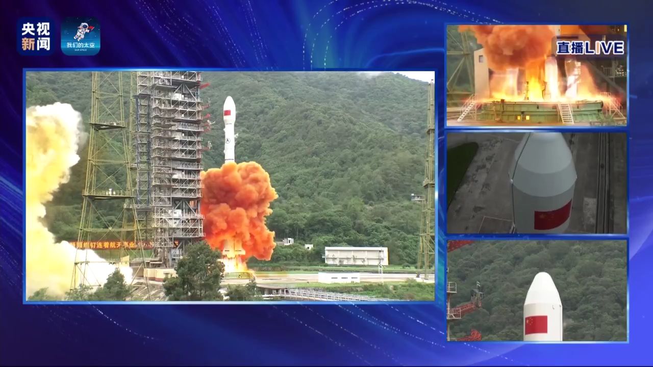
China completed its worldwide BeiDou navigation satellite system with the launch of its final satellite on June 23, according to China Global Television Network.
The satellite launched aboard a Long March-3B carrier rocket from the Xichang Satellite Launch Center at 9:43 a.m. Beijing time (0143 GMT) on Tuesday, marking the completion of the country’s domestically developed BeiDou constellation.
The launch followed a delay of after originally being scheduled for July 16 because of a technical issue discovered in pre-flight tests.
The final satellite is a geostationary earth orbit satellite of the BDS-3 system. It is the 30th BDS-3 satellite and the 55th BeiDou satellite. BDS-3 is a a 30-satellite navigation system.
BDS-3 offers high-precision positioning and short message communication.
Begun in 1994, BDS-1 was completed in 2000 to provide services to China. In 02012, BDS-2 was finished, and has provided navigation service to the Asia-Pacific region. Once the final satellite achieves orbit and is checked out successfully, BDS-3 will provide navigation services worldwide.
The 1,174 page set of reports are comprehensive and document the first phase of what is intended as a multi-phase effort.
Graphic: RIN and RNTF
The webinar will present how maritime positioning requirements were systematically developed; an assessment of current and future positioning systems to deliver the required performance and integrity; rigorous gap analysis, showing where performance falls short, as well as options to solve these issues; and a roadmap of steps needed to take — and by whom — toward maritime resilient positioning.
Webinar speakers will include Jonathan Turner of the MarRINav project team, Alan Grant of the Royal Institute of Navigation and Dana Goward of the Resilient Navigation and Timing Foundation.
In 2018 the first-ever European Radionavigation Plan said “It is recognized that [..] GNSS should not be the sole source of PNT information. Alternative PNT systems, not necessarily using radio frequencies, should thus be put in place where the criticality of the application requires it.”
Graphic from MarRINav report showing system of systems approach to PNT resilience and reliability. (Image: Resilient Navigation and Timing Foundation)
In 2019 the European Space Agency (ESA) published a permanent open call for proposals for positioning, navigation, and timing studies and systems, including those that had nothing to do with space.
“Maritime navigation and port operations are critical for almost every nation,” said Jonathan Turner, one of the MarRINav project team. “As an island nation with a strong maritime heritage, we in the United Kingdom perhaps have an even greater appreciation of this.” Turner is co-founder of the blue economy solutions company NLA International, which led a team of eight organizations cooperating on the project.
While MarRINav focused its analysis on the United Kingdom, the intent was to provide information, and an analysis framework, that could also be used by other nations.
Maritime is one of sectors most dependent upon GNSS, according to the project reports, and a sector with great awareness of GNSS vulnerabilities and their consequences. MarRINav concludes that integrity and resilience are two of the most important parameters for maritime navigation.
Maritime is also one of the sectors most ready to integrate space and terrestrial navigation systems, according to the report’s authors. The International Maritime Organization has already introduced a performance standard for a multi-system receiver, or MSR, that will incorporate a wide variety of navigation signals.
Despite the distractions of Brexit over the last four years, the United Kingdom has been particularly focused on its vulnerability to GNSS outages.
In February of this year the UK government announced it was establishing a virtual National Timing Centre to protect the nation from the risk of GNSS failure, and in March the final MarRINav report was published.
Among the project’s findings are that:
The United Kingdom needs a comprehensive maritime PNT architecture with multiple, diverse sources to ensure continuity of maritime operations
Such a “hybrid solution” could benefit other sectors, especially if non-maritime needs were considered early in the design
New PNT systems should be terrestrial and sovereign
Establishing such a system for the UK has a very positive benefit to cost ratio
Important aspects of the new architecture are E-GNSS (Galileo and EGNOS), Enhanced Loran (eLoran) and the Ranging Mode (R-Mode) of the VHF Data Exchange System (VDES), and complemented by the development of a specific Maritime Receiver Autonomous Integrity Monitoring (M-RAIM) algorithm.
LOCATA or a similar local positioning system should be implemented at UK ports to provide a backup for container operations.
Satelles Satellite Time and Location may have potential, but its utility has yet to be demonstrated for maritime.
Inertial Labs’ TAG-200 two-axis and TAG-300 three-axis gyroscopes are designed for use in harsh environments. (Photo: Inertial Labs)
Inertial Labs has released its TAG-200 two-axis and TAG-300 three-axis gyroscopes, developed for electro-optical systems, gimbals, line-of-sight, and pan and tilt platforms for stabilization and pointing applications.
According to the company, TAG-200 and TAG-300 utilize advanced performance, tactical-grade MEMS sensitive elements, of which size, power consumption, reliability and performance are ideal for accomplishing complex tasks requiring accurate stabilization of assorted platforms.
The gyroscopes, designed for use in harsh environments, can withstand extreme shock and vibration in accordance with MIL-STD-810 ground mobile use, Inertial Labs added. In addition, they are fully digitized, include built-in test functionalities and have no moving parts.
Key advantages of the dual TAG-200 and triple TAG-300 axis gyroscopes include low noise, low latency, wide bandwidth, high data rate, low bias drift, low VRE, high MTBF and ITAR-free, Inertial Labs said. The gyroscopes are factory calibrated over operational temperature range with low non-orthogonality and misalignment between sensitive elements. They’re also QA/QC tested and supplied with individual calibration and acceptance test certificates.
Inertial Labs, based in Paeonian Springs, Virginia, manufactures orientation and navigation sensor solutions.
UPDATE: The search was called off on Tuesday afternoon. Additional information is available in this Evening Standard article.
David Last (Photo: @harriethallphoto via Dana Goward)
Just before 13:00 GMT on Nov. 25, a private plane piloted by David Last, former president of the Royal Institute of Navigation, disappeared from radar and hit the sea approximately two miles off the coast of Wales.
On-going search and rescue efforts have recovered pieces of wreckage and personal effects.
“Last was one of the most respected and well-loved figures in the worldwide positioning, navigation, and timing community. His loss creates a hole that cannot be filled,” said Dana Goward, president of the Resilient Navigation and Timing Foundation. “David was a close personal friend. Our grieving will not be brief.”
According to BBC News, the search for the missing plane and its pilot off the Welsh coast resumed on Nov. 26. North Wales Police said the light aircraft was flying from Caernarfon Airport to the Great Orme, Llandudno, and back on Monday when it disappeared. There were no other passengers and officers were supporting the missing pilot’s family.
The Maritime and Coastguard Agency said the search has resumed around Puffin Island, near Penmon, Anglesey. A plane carrying a sonar technology camera is searching the area as well as a lifeboat, helicopter and coastguard teams on foot.
David Last was a U.K. consultant engineer specializing in radio navigation and communications systems, professor emeritus at the University of Bangor, Wales, and past president of the Royal Institute of Navigation.
He also was a member of the expert panel and co-author of the January 2018 Blackett Report.
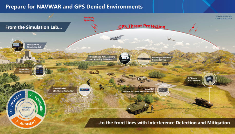
Resilient positioning, navigation and timing (PNT) company Orolia has nearly tripled new U.S. military orders for specialized resilient PNT solutions in the third quarter of 2019, the company stated in a press release.
Orolia said its solutions are helping to meet growing military demand for assured operations in Navigation Warfare (NAVWAR) and GPS-denied environments.
In the third quarter, Orolia unveiled its new Simulation and Interference, Detection & Mitigation (IDM) suite, announced the acquisition of GNSS simulation company Talen-X and introduced new advanced GNSS jamming and spoofing countermeasures.
The new U.S. military orders include the full range of Orolia’s resilient PNT solutions.
“This rapid industry response affirms Orolia’s commitment to delivering trusted military solutions for GPS denied environments,” said Paul Zweers, Orolia vice president of sales and marketing.