The U.S. Department of Transportation is preparing for a GPS backup and complementary positioning, navigation and timing demonstration for the Department of Defense at the Joint Base Cape Cod, Massachusetts.
Demonstration for testing is expected to begin in the spring of 2020, and DOT is seeking contractors to make Building #2410 at the base functional so that the demonstrations can be held there.
Diana Furchtgott-Roth, deputy assistant secretary of Transportation for Research and Technology, is leading the project. Working through the Volpe National Transportation Systems Center, Furchtgott-Roth’s goal is to demonstrate as many of the technologies as possible and conclude the effort by March of next year.
The 28th edition of the European Navigation Conference (ENC 2020) will be held May 11-14 at the International Congress Center in Dresden, Germany.
The conference is hosted by the German Institute of Navigation (DGON). Because of the rapid development of analog and digital technologies, there is increasing progress in performance of GNSS.
The conference brings together scientists, engineers and international experts to discuss new ideas, latest research results, future developments and new applications. High-level presentations will allow each participant to receive an in-depth view on the current status of satellite navigation technology. Topics include:
GNSS Updates & Policies
GNSS Algorithms & Techniques
Resilience and Autonomy
Multi-Sensor & Data Fusion
Aviation & Marine Navigation
Space & Science Applications
Mobility and Transportation
Speakers. Keynote speakers will be Julia Klöckner, Federal Minister of Food and Agriculture, and Dr. Pascale Ehrenfreund, German Aerospace Center, chair of the Executive Board.
Expo. A technical exhibition provides an opportunity for companies, agencies and research institutions to display their offerings; it will be directly placed in the conference area.
Abstracts. The European Navigation Conference aims to provide a forum for both academic and industrial professionals in navigation topics from all over the world and to bring together academicians, researchers, engineers, system analysts, graduate and undergraduate students with government and non-government organizations to share and discuss both theoretical and practical knowledge. Experts are invited to submit outstanding and valuable original research papers and participate in the technical exhibition during the conference. The deadline for abstracts is Nov. 1, 2019.
About Dresden. The city of Dresden is located at the river Elbe and has a long and colorful history. Although Dresden is a relatively recent city of Slavic origin, it is well-known as the capital and royal residence for the Electors and Kings of Saxony, who for centuries furnished the city with cultural and artistic splendor. After the reunification process in 1989, Dresden has regained importance as one of the cultural, educational, political and economic centers of Germany and Europe.
News from the U.S. Army Space and Missile Defense Command/Army Forces Strategic Command
The secretary of the United States Army has designated the U.S. Army Space and Missile Defense Command/Army Forces Strategic Command as the Army’s representative to identify and advocate for positioning, navigation and timing (PNT) information as well as establish and formalize joint navigation warfare, or NAVWAR, requirements.
“Navigation warfare is really about taking a look at different position, navigation, and timing signals and figuring out how the signals flow; the potential for adversaries to disrupt our ability to use them in the future; and how can we not only protect ourselves from the enemy denying us with those abilities, but also how can we do the same to our enemies and affect them and disrupt them in a multi-domain operational environment,” said Col. Timothy G. Dalton, USASMDC/ARSTRAT U.S. Army Training and Doctrine Command, or TRADOC, Capabilities Manager for Space and High Altitude, or TCM SHA.
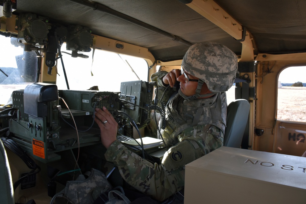
Soldiers in the field learn how to operate in a NAVWAR environment. (Photo: U.S. Army)
What NAVWAR Does. NAVWAR allows the Army to take deliberate defensive and offensive actions to assure U.S. forces PNT information through coordinated employment of space, cyberspace and electronic warfare operations. PNT data enables the Army to precisely move, shoot and communicate; extend its operational reach; control the tempo of operations; and perform mission command, all without adversarial interruption.
NAVWAR capabilities include electronic protection which includes systems and capabilities required to defend platforms and systems against electronic acts in the GNSS electromagnetic spectrum.
The Army has more than 250,000 GPS-dependent systems.
Additionally NAVWAR provides electronic support to sensors and software used to search for, intercept, identify, locate or localize, and report sources of intentional and unintentional radiated GNSS electromagnetic interference for mitigation and planning future operations.
NAVWAR can also provide electronic attack with capabilities to seize and sustain the initiative by actively degrading or denying the GNSS electromagnetic spectrum to adversaries in multi-domain operations.
The Army is dependent on the use of this data with a typical brigade combat team depending on more than 28 different systems and 600 total systems that leverage PNT. The Army has more than 250,000 GPS-dependent systems.
“As the Army goes forward in multi-domain operations, what we see the battlefield becoming is a contested environment,” Dalton said. “What that means is there are adversaries that will look to challenge the United States across all operational phases and domains. These enemies will have the capability to disrupt signals, like GPS, that can impact a wide range of military and civilian activities.
New NAVWAR Concept. SMDC is developing a TRADOC-sponsored Army NAVWAR concept that will be used to establish a baseline for how the Army will execute the NAVWAR fight.
The Army is highly dependent on the use of GPS-delivered PNT data. NAVWAR prevents the use of GPS by hostile forces while ensuring unimpeded use for U.S. forces and allies.
“In the command’s advocacy role we work with the joint and Army communities to examine what the Army needs to be able to accomplish the mission through navigational warfare,” Dalton said. “We work with a community of interest to determine the requirements that will build capability and reduce shortfalls in this mission area.
“This includes activities like updating doctrine, our organizational structure, ability to train the force, and ultimately determine if we need additional equipment, or holistic solutions to protect capabilities and disrupt the enemy on the navigation warfare side,” he added.
Training and Research. SMDC, in conjunction with U.S. Forces Command and the Joint Navigation Warfare Center, supports training events under degraded GPS conditions. The goal is to enable tactical formations to develop and train tactics, techniques and procedures that enable Army formations to work.
“We help develop and focus the capability requirements for the Army,” Dalton said. “But we are integrating with a larger community, led by the Assured Positioning, Navigation and Timing Cross-Functional Team that is focused on modernizing the Army in this mission area.”
SMDC is the Army lead for institutional unity of effort on NAVWAR with several research, development, test and evaluation and capability integration efforts working on the issue independent of one another.
“It is definitely an exciting time for NAVWAR,” Dalton said. “The Army, services and Department of Defense, as a whole, have started to embrace the importance of this mission area and understand the competitive advantage the U.S. and our partners can gain while denying the adversary the ability to conduct operations with respect to navigational warfare.”
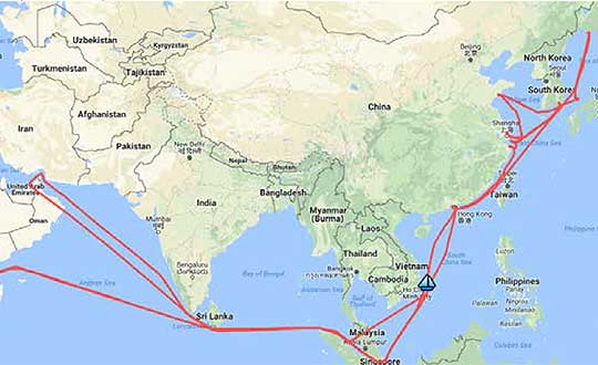
A year-long project aboard a commercial cargo ship collected tens of thousands of snapshots of radio-frequency interference in the GNSS band on a passage from Spain to Korea and back. Most interference was detected in busy port areas, less interference while transiting along coasts, and while least frequent, interference was still found in the open ocean.
Researchers at the German Aerospace Center (DLR) are still analyzing the vast amount of GNSS disruption data collected during the year-long project. Two papers have already been published about this project, and more are on the way, according to principle researcher Emilio Pérez Marcos.
In a paper presented at the Institute of Navigation last year, Marcos and his co-authors outlined the results of the last five months of this unique sampling experiment. Detection equipment was mounted on a large Hapag-Lloyd container ship. The antenna was mounted about 50 meters above the water line and provided a line-of-sight of 25km or more. The L1/E1 and L5/E5a frequency bands were continuously monitored. In addition to a “Snapshot” recording device used to save raw data samples (time snapshots), a more resilient DLR multi-antenna receiver was used to assess the impact of interferences in beamforming array GNSS receivers (semi-resilient).
As might be expected, the most interference was detected in busy port areas. Less interference was experienced while transiting along coasts. While it was the least frequent, interference was still detected during open ocean transits.
Table: Emilio Pérez Marcos and co-authors
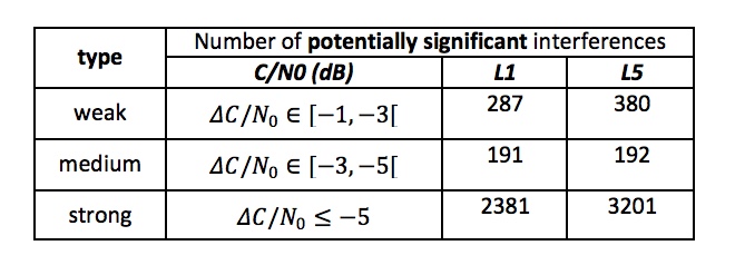
Of the 39,045 snapshots recorded, 6,632 contained radio frequency interference at 1dB or higher. Separate tests have shown that many single antenna GNSS receivers begin to perform poorly with interference signals greater than 1dB. The other 32,413 snapshots could represent interference signals that may have come from weaker transmitters, sources more distant from the ship, been the result of adjacent band transmissions, or other phenomena.
Three particularly strong and persistent interference incidents were noted in the paper.
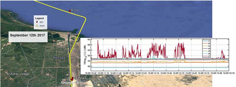
The first was detected when the vessel was transiting the Suez Canal northbound. The interference lasted around five hours and 60km. At several points the interference prevented the DLR semi-resilient GNSS receiver from working properly, which would mean that any single antenna GNSS receiver would cease to function completely.
Vessel going north in Suez Canal. RFI detectable during approx. 60 km. Inset: Eigenvalues during the 5 hours that the RFI was detectable. (Graphic: Emilio Pérez Marcos)
The second caused the DLR receiver to fail when the vessel was entering Jebel Ali, the port of Dubai in the United Arab Emirates. The DLR receiver provided some resilience thanks to its beamforming capabilities; again any other receiver would have suffered the interference effects earlier being unable to provide any PVT. The receiver did not return to proper operation for 11 days and 5,000km. The reason for this is uncertain and under investigation.
Particularly strong interference (45dB) caused the third incident and resulted in the DLR receiver failing for three days. It began when the ship was entered the highly trafficked Malacca Straits.
The equipment used also allowed researchers to determine direction of arrival for the interfering signals and to evaluate whether the interference was a spoofing signal.
For the reported strong interference events, DLR consulted the captain of the ship, who attested and confirmed the loss of PVT in the ship’s own GNSS receiver, with all the consequences that this implies for the systems that rely on it.
The paper, “Interference and Spoofing Detection for GNSS Maritime Applications,” was presented at the ION GNSS+ conference in Miami in September of 2018. It described the last phase of a yearlong measurement effort aboard the ship by DLR. An earlier phase of the campaign has also been published in E. P. Marcos et al., “Interference awareness and characterization for GNSS maritime applications,” 2018 IEEE/ION Position, Location and Navigation Symposium (PLANS), Monterey, CA, 2018.
The authors are preparing additional papers to describe more of the results from the larger project.
Association recognizes key role the agency has played in furthering GPS.
The GPS Innovation Alliance (GPSIA), an organization dedicated to furthering GPS innovation, creativity and entrepreneurship, commends NASA — the U.S. National Aeronautics and Space Administration — on its momentous 60th anniversary. GPSIA celebrates the occasion by recognizing the vital role NASA has played in furthering and facilitating the growth of GPS around the world.
NASA has long been an integral supporter of GPS technologies, from its origins in the first space shuttle program, to the launch of the International Space Station (ISS), to the recent announcement of plans to develop an artificial intelligence-based GPS for space.
Throughout its history, NASA has played a critical role in the success of expanding GPS systems. NASA manages the Navigator GPS receiver, developed by its Goddard Space Flight Center, which has pushed GPS satellites out of lower earth orbit and beyond to enable high altitude applications and track weaker and more rural GPS signals with increased accuracy.
The Global Differential GPS System (GDGPS), a network of more than 350 GPS monitoring stations from 200 contributing organizations in 80 countries developed and operated by NASA’s Jet Propulsion Laboratory, provides an unparalleled combination of real time positioning accuracy and availability and acts as the largest network providing global, multiply-redundant, real time coverage of all GPS satellites at all times.
“GPS contributes immeasurable value to our economy and is used in almost every industry sector,” said NASA Administrator Jim Bridenstine. “It is crucial for our way of life on Earth — the way we communicate, navigate, conduct banking transactions, and so much more rely on our GPS systems. As NASA looks to its future endeavors in exploration and discovery, GPS will remain a cornerstone of technology to accomplish its missions. NASA looks forward to its continued work with the GPS Alliance.”
With the establishment of the National Executive Committee for Space-Based Positioning, Navigation, and Timing in 2004 and other governing bodies since, NASA has also acted as a thought leader on policy trends in the field, advising on and advocating for protections of GPS , one of the world’s most important and ubiquitous public resources.
“The alliance, on behalf of its members and the GNSS industry, congratulates NASA on six decades of cutting-edge innovation and wishes the agency continued success for many decades to come,” said J. David Grossman, executive director of the GPS Innovation Alliance. “As one of the most recognizable technologies in the world, GPS supports navigation, public safety, financial transactions and utilities and varied industries worldwide. We applaud NASA for its unwavering commitment to scientific innovation and to GPS around the globe, now and in the future.”
The GPS Innovation Alliance recognizes the ever increasing importance of GPS and other GNSS technologies to the global economy and infrastructure and is firmly committed to furthering GPS innovation, creativity and entrepreneurship. The GPS Innovation Alliance seeks to protect, promote and enhance the use of GPS.
The conference, sponsored by the Royal Institute of Navigation (RIN), is a premier forum for the presentation of research and advances in navigation. The theme of INC2018 is Navigation Challenges and Societal Benefits.”
According to RIN, INC2018 will offer a unique format of multiple keynotes throughout the three days. The sessions and themes will address key navigation topics, including cognition in navigation; human factors in navigation systems; connected autonomous vehicles; innovations in accuracy and indoor navigation, innovations in resilient positioning, navigation and timing; mapping, imaging and augmented reality; and progress in quantum.
This year’s INC will also feature a one-day symposium covering topics related to cognitive navigation. According to RIN, cognitive navigation is distinguished from other kinds of navigation methods/technology by the dependence on some type of representation of the to-be-navigated space. The goal of the symposium is to bring academics and industry experts together to facilitate the development of our understanding of and design for cognitive navigators, so that buildings and technology can work in a seamless way with human psychology.
Rohde & Schwarz’s Navigation and Guidance Solutions Learning Center offers brochures, articles, technical documents, videos and posters. (Image: Rohde & Schwarz)
Rohde & Schwarz has updated its Navigation and Guidance Solutions Learning Center with several features, including application notes, white papers, training videos and products for aerospace and defense applications.
Rohde & Schwarz provides accurate, flexible, high-performance test solutions to cover every need — from design, development, calibration and production to operational maintenance for ground based systems and advanced hybrid constellation simulations for GNSS systems, the company said.
The navigation learning center now includes the latest Rohde & Schwarz solutions for GNSS testing and avionics testing. It highlights the latest company products, including aeronautical radio navigation measurement solutions, vector signal generators and GNSS signal simulators. It also provides users with brochures, articles, technical documents, videos and posters.
The navigation center is organized under three main categories: radar and electronic warfare test, satellite communication systems, and navigation and guidance.
The U.S. Army is drafting new rules for the use of GPS receivers in weapon systems to combat spoofing and jamming attacks, as well as signal loss in GPS-denied environments, according to news reports.
The six- to seven-page capabilities requirements document is awaiting a signature from Army leadership, according to Willie Nelson, director of the assured PNT (positioning, navigation and timing) cross-functional team. Nelson spoke to reporters Oct. 9 at the Association of the U.S. Army annual meeting in Washington, D.C.
The Army has been trying for years to complete a GPS requirements document, a “system of systems architecture for assured PNT.” But with virtually every device equipped with GPS, the document would have been too big and too broad, Nelson said.
(Photo: U.S. Army)
The approach now is for separate sets of requirements: one for mounted equipment (now complete and awaiting the signature), a dismounted requirement, and situational awareness.
The difficulty facing the Army is the plethora of PNT systems in use. For instance, an armored personnel carrier may have five to seven unconnected GPS receivers, some with encryption, some without. The weakest receiver could negatively affect the vehicle, Nelson said.
With the new requirements, Army vehicles will have a consolidated, networked, software-based PNT solution. Dismounted receivers used by soldiers will have similar requirements.
Industry will be asked for specific solutions within each of the PNT sectors rather than an “all of the above” solution.
The Army is also expected to create a training program for soldiers that operate PNT systems.
Researchers from NASA’s Frontier Development Lab (FDL) and Intel are proposing a way to navigate on a new planet using artificial intelligence (AI).
The researchers presented their planetary navigation research during an Intel event on Aug. 16.
The immense challenge of building GPS-similar constellations around every planet or moon could be avoided by using imagery, according to researchers Andrew Chung, Philippe Ludivig, Ross Potter and Benjamin Wu.
The team developed a system for simulating the Moon’s surface so that AI could be used for navigation on the surface.
How It Works. The researchers created a highly detailed digital model of a virtual moon using 2.4 million images of its surface. The images represent ones that might be taken by a rover.
The AI learned what this moon looks like by being fed the millions of images, and then used its neural network to create a model of the virtual moon.
According to the team’s presentation, this was enough to effectively enable navigation on the virtual moon’s surface.
With the model in place, a person merely needs to take a photo of their surroundings on the surface. Based on the photo, the AI determines the person’s location and shows how to navigate to a destination. The AI would even understand the distortions of known features from the point of view of the camera.
The team wants to try to do the same thing with a real celestial body: Mars. They think they have enough satellite images to make it work.
If they’re right, the first Martian visitors could navigate the Red Planet by photo.
By Sam Pullen, Stanford University; Jim Kilfeather, Jim Goddard, Tom Nowitzky, Brinda Shah, Wen Doong, David Kagan, and Kerry Greer, Globalstar. To be presented at ION-GNSS+ 2018.
Globalstar is developing a connected car program for continuous, worldwide service to vehicles via satellite and terrestrial communications links.
This combines PPP corrections provided globally by the second-generation Globalstar low-Earth orbit (LEO) constellation with local-area corrections via LTE cellular signals in urban areas for connectivity anytime, anywhere. Both signals are broadcast at 2.4 GHz and include pilot channels used for ranging, augmenting GNSS ranging and providing robustness against jamming and spoofing.
The program provides enhanced navigation via continuous augmentation of GNSS with data derived from ground-based reference networks for sub-meter accuracy and integrity bounds on navigation errors to probabilities as low as 10-9 per operation. When this is combined with other on-board sensors and data such as lidar, radar, optics and IMUs, it will be possible to operate autonomously under almost all conditions with a very high degree of safety.
The key is combined use of PPP corrections globally and local-area CDGNSS/RTK corrections in high-density urban regions where it is economically beneficial. Both sets of augmentations are made available to vehicles. The global approach on the left side of the figure is primary, given its near-worldwide coverage based on the LEO satellite network broadcasting corrections within its licensed communications spectrum at 2.4 GHz. The P/N-modulated pilot component of the Globalstar satellite signals will be used for ranging to augment GNSS and provide additional robustness to RF interference or spoofing at GNSS frequencies.
The Korea Research Institute of Ships and Oceans Engineering (KRISO) has awarded UrsaNav a contract to supply an eLoran Transmitter Test Bed System in the Republic of Korea.
UrsaNav, the exclusive, worldwide distributor of Nautel’s NL Series transmitters, will provide eLoran transmitter technology, as well as timing and control equipment.
A meeting to kick off the eLoran work. (Photo: UrsaNav)
The contract, awarded through UrsaNav’s agent Dong Kang M-Tech, represents the first phase in a broader program to upgrade Korea’s Loran-C stations to be the foundation of a sovereign Enhanced Loran (eLoran) positioning, navigation and timing (PNT) service.
The Republic of Korea recognizes the challenges associated with relying solely on space-based signals, the relative ease with which those signals can be jammed or spoofed, and the necessity to provide trusted time and position to its citizens and critical national infrastructure, UrsaNav said in a press release.
The press release also included the following description of the importance of eLoran.
Accurate time and position are necessary components upon which many critical infrastructure sectors rely, including maritime, aviation, electrical distribution, telecommunications, finance/banking, and digital broadcast. A complementary PNT (CPNT) service provides continuity of operations through alternative and diverse timing and positioning information. CPNT is a vital element in ensuring national security and assuring Trusted Time and Trusted Position.
eLoran is the latest in the longstanding series of low-frequency (LF), LOng-RAnge Navigation (LORAN) systems. It meets the accuracy, availability, integrity, and continuity performance requirements for maritime harbor entrance and approach maneuvers, aviation En Route and Non-Precision Approaches, land-mobile vehicle navigation, and location-based services. It provides bearing (azimuth) information, even when the user is not moving, and has built-in integrity. Users within the coverage area can simultaneously synchronize their timing to absolute (not relative) UTC. Of equal importance is that the eLoran signal includes one or more Loran Data Channels that are available to provide one-way, low data rate, “Short Message Service” information.
eLoran is completely independent of GPS/GNSS, operates in the internationally protected 90 to 110 kHz spectrum, is built on internationally standardized Loran-C, and provides a high-power PNT service for use by all timing and navigation users. SAE International expects to release eLoran standards this year. The RTCM also has maritime-related eLoran standards underway.
eLoran is a key vertex of a Resilience Triad that would typically include space-based, terrestrial, and at least one other PNT source. It is a very-wide area (i.e., country-wide or “continental”) source of PNT that continues providing a resilient solution even when GNSS may be unavailable or untrustworthy. eLoran delivers information comparable to that of GNSS, but with completely different phenomenology. It is a very high-power, LF, pulsed transmission, whereas GNSS are low-power, UHF, multiple modulation scheme transmissions. eLoran is literally at the other end of the spectrum from GNSS, and has completely dissimilar failure modes. That is, an issue that disrupts GNSS is unlikely to disrupt eLoran. The unique characteristics of eLoran enable its use in environments where GNSS does not work very well, or at all (e.g., indoors, underwater, underground, and in mountain or urban canyons).
eLoran is exceptionally difficult to spoof or jam, and it is nearly impossible to do so at a distance. Just as equipment required to spoof and jam GNSS must mimic relatively low powered GNSS transmissions, spoofing and jamming eLoran requires very high powered transmissions. Equipment needs alone to disrupt eLoran over a significant area would be almost prohibitive for any actor other than a nation state engaged in open conflict. This is the reason that an independent assessment by researchers at Stanford University described eLoran as “for all practical purposes, unjammable” across any significant area. A MITRE paper concluded: “The analysis shows a very low probability of successfully producing operationally significant interference.”
The 2018 International Navigation Conference (INC), which will take place Nov. 12-15 at the Mercure Bristol Grand Hotel in Bristol, United Kingdom, will focus on navigation challenges and societal benefits.
According to event organizers, the keynote speakers at the event will focus on developments in resilient positioning, navigation and timing (PNT) innovations; PNT for connected autonomy; human factors and cognition in navigation; mapping and imaging; and progress in quantum technology.
In addition, sessions and themes at INC 2018 will address key navigation topics topics from technical, regulatory, ethical, cognitive and human perspectives.