At the opposite end of this book, my esteemed colleague Eric Gakstatter gives you his Top Five news stories of the recently passed year, from a system point of view. Spend five minutes here in this column, and I’ll toss up the Top Ten for GNSS business, as reported in this magazine.
Not the biggest money deals or revenue generators, at least not in the short term. But the most significant in terms of breaking new ground, pushing out frontiers, integrating with other technologies — the modes through which industry grows and prospers.
I’m leafing through my back copies in reverse order. This listing goes not by prominence, but by reverse chronology.
PNDs Up, Then Down By 2015. When you are doing well, rest assured that someone is gaining on you. Smartphones will gradually take over the personal nav market. Stay flexible, innovate, and be prepared to change horses in midstream.
Rockwell Delivers New MUE. While military user equipment gave this industry its start, the receivers themselves have always lagged behind product available to civil users. Still, security features in the GB-GRAM-M foreshadow what all receivers may eventually require.
Triumph V.S. from JAVAD. Supercharged with capabilities, a veritable surveyor’s arsenal, and probably a gamechanger — whether or not it makes it in the marketplace. A visionary product.
NovAtel OEMV-1DF. Almost every month, another smallest-yet consumer-grade GPS receiver emerges. But when high-precision, dual-frequency receivers grind down their footprint and power requirement, you know this is a future wave that will sweep everything along. Not the only tiny high-performance OEM receiver, mind you, just the latest.
LLC Rusnavgeoset. The joint venture between Trimble and a Russian company will help drive the commercialization of GLONASS, an aspect that system has not yet truly seen. We all talk about the second GNSS of choice, but the second commercialized GNSS is what we really want.
Smartphone Explosion. The flipside to the first story. This year’s models from Apple iPhone, Google Android, Blackberry, Windows Phone 7, and all their kin, if not built around location as Apple claimed, certainly have it as core feature. The flip of the flipside: pricing for the GPS component is cut-throat. Absolutely the worst you’ve ever seen.
GPS-Enabled USB Drive. That’s all it takes — well, download some software and buy a contract — to make a laptop location-aware.
Spirent Assisted-GLONASS Testing. One more sign that the Russian system, against betmakers’ odds, may yet become the trusty sidekick. Soon, if your mobile doesn’t have it, it’s not top-of-class.
One-Chip Receivers-Plus. Hardly breaking news, since it’s been talked about and even done, sort of, for years. TI, Broadcom, Qualcomm, CSR, and silent runners like Sony and Panasonic are all adding some communication transceiver(s) to GPS and squeezing them onto a single piece of silicon.
No News Is Big News. Actually not reported here or anywhere, because neither party wants to reveal anything, but some of the biggest deals are cut by chip manufacturers (such as STMicroelectronics, to name just one), with automobile makers around the world. Like it or not, the car/truck is the dominant mechanical paradigm of our age. And if location is in it . . .
We are indeed fortunate to be part of, and partners in, such a vital scene. Best wishes for this New Year.
Yowza!!, an application designed for the latest GPS-enabled iPhone 3G and 3GS models and iPod Touch, brings relevant coupon offers to customers based on their location.
“Any time you insert a concept such as location into a marketing program, you end up with a far more compelling value proposition,” states Mike Wehrs, president of the Mobile Marketing Association.
Sales and discount offers via Yowza!! can be updated in real-time and targeted by region or store location. “The phone will deliver a list of stores within one mile that have offers on Yowza!!,” said August Trometer, co-founder of the recent startup. Users show the barcode and digital mobile coupon on their handset at checkout to redeem the discount on their purchase.
“We work directly with merchants; they provide us with their latitude and longitude, we get the GPS coordinates, do a database search with a proprietary algorithm,” said Trometer. “The phone constantly goes back and forth between our app, touching data from our database. When the person touches their location, it touches a new set of data in the database. The phone will work with them to keep delivering the closest store. There’s a lot of work on the database end of things.”
One drawback of the app is that it has to be turned on to work — it does not sit in the background, waiting to be activated by incoming offers. “Users have to give the application access to their GPS coordinates,” explained Trometer. “But the power of the device and all the applications it brings make it silly to turn off the location capability.”
Retailers that have signed with Yowza!! include Sears, McDonald’s, The Container Store, and more. Unlike traditional forms of couponing such as newspaper ads, Yowza!! offers can be updated in real time and targeted by region or store location.
Trometer expects to announce Yowza!! capability through other GPS-equipped phones: Blackberry Storm, Google’s Android-based phone, and the Palm Pre. “All three makers allow developer access to the GPS and this is very important, it’s crucial, obviously. They also have a high-res screen, which is a requirement for our scannable barcode that the user shows to the merchant.”
Referring to GPS handsets that lack a high-res screen, he claims “The other phone manufacturers really have an uphill battle right now.”
Whose GPS? The source of the GPS chip within Apple’s iPhone remains a mystery. “Even people who have done teardowns of the devices, the chips are completely blank,” says Trometer.
“There are so many possibilities, we’re just scratching the surface right now with what can be done,” Trometer said. “The mind reels with the things that can be done with that.”
>> SURVEY & CONSTRUCTION
Hemisphere, Juniper Jointly Offer DGPS Receiver for Demanding Environments
Juniper Systems and Hemisphere GPS offer the XF101 DGPS receiver for the Archer Field PC, designed to deliver sub-meter DGPS to location-based applications in demanding environments.
According to the companies, the Hemisphere GPS XF101 DGPS receiver provides: Crescent GPS technology for sub-meter accuracy; COAST technology to maintain accuracy during temporary loss of differential signal; optional external antenna for centimeter-level accuracy; low power consumption; modular connection for rapid field use; real-time or post-processed DGPS data collection; and multipath minimization.
The XF101 with the Archer is priced at less than $2,500. It fully supports mobile GIS applications such as ESRI ArcPad and OnPoz GNSS Driver.
>> AVIONICS
NovAtel Receiver for Next-Gen WAAS
NovAtel announced receipt of a contract from the U.S. Federal Aviation Administration (FAA) to develop the next generation Wide Area Augmentation System (WAAS) reference receiver, the GIII. Total contract value can go up to $9.7 million.
NovAtel has worked with the FAA WAAS program since 1995, providing and supporting two previous generations of reference receivers for the WAAS ground network. The technology refresh will add support for new L1C, L2C, and L5 signal capabilities, on a qualified RTCA DO-178B software and DO-254 hardware platform. The WAAS GIII receiver program is scheduled to be completed over the next three years, and will include growth provision for further signal capability such as Galileo. As many as 14 receivers will be produced in the GIII development and qualification program.
>> FLEET TRACKING
AT&T, Trimble Fleet Management
AT&T has broadened its fleet and mobile asset management portfolio with the latest version of Trimble’s GeoManager solution, which helps reduce fuel and maintenance costs by enabling operators to manage their vehicle assets more efficiently.
Trimble GeoManager enables transportation and field-service fleet operators to track their mobile workers and assets through software and GPS modems running on AT&T’s wireless network. GeoManager integrates GPS, wireless data communications, and a browser interface to help manage mobile workers, the mobile worker’s work, and the mobile worker’s assets.
AT&T and Trimble have jointly offered fleet-tracking solutions for several years. The GeoManager update features improved map and status, new landmark uploads, WLAN usage, schedule report enhancements, driver logs, and organizational hierarchy modifications.
>> TIMING
Timing Vulnerability Concern Grows
Industrial and enterprise users in telecommunications and utilities privately express concern over revelations from the April Government Accounting Office (GAO) report, “Global Positioning System: Significant Challenges in Sustaining and Upgrading Widely Used Capabilities.” The GPS signal is used for synchronizing almost all global computer networks belonging to the military, utilities, banks, telecomms, television companies, and many more.
Backup? What Backup? These same companies point to a continued lack of commitment on the part of the U.S. government to stable and reliable backup for GPS. As long ago as 2007, in comments before the Department of Transportation, wireless carrier Sprint Nextel stated: “Sprint Nextel Corporation respectfully requests that the U.S. government continue to operate and invest in the LORAN-C and eLORAN systems. Should the DOT and DHS decide to decommission the LORAN-C system, Sprint Nextel recommends that the agencies delay doing so until the eLORAN system is fully operational. Sprint Nextel and other communications providers use the frequency signals of the Global Positioning System, LORAN, and atomic clocks for multiple levels of redundancy and diversity in their networks. Therefore, Sprint Nextel urges the DOT and DHS to carefully weigh decisions which might impact LORAN’s availability to the nation’s voice and data communications networks.
“The loss of a primary reference source (PRS) can negatively impact a telecommunications network, and those impacts can vary from minor short-term noise impairments to long-term network-wide outages. Both traditional wireline services and newer wireless services require a precise frequency reference for basic service delivery . . . . The continental U.S. portion of the Sprint Nextel network requires a PRS at thousands of switch sites, interconnection sites
, and cell tower sites to ensure reliable service delivery.”
Deadlock on Capitol Hill. Competing resolutions to either discontinue or adequately fund LORAN and eLORAN continue fencing in Congressional subcommittees in both chambers. Nothing has changed since Sprint commented two years ago — aside from a potential rise in the susceptibility of GPS to jamming, unintentional interference, and decreased availability.
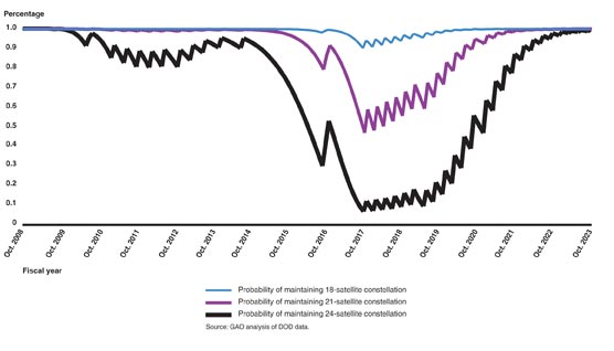
GAO REPORT, FIGURE 5. Probability of maintaining constellation of at least 18, 21, and 24 GPS satellites based on reliability data as of March 2009 and a two-year GPS III launch delay.
>> TIMING
Telecom Clock from EndRun
EndRun Technologies announced a Telecom Clock Option for its Meridian Precision GPS Timebase, which provides accurate and stable GPS-synchronized outputs for military communications, aerospace, broadcast, engineering and calibration laboratories, telecommunications, and more.
The option was designed as a plug-and-play module that can supply any combination of E1, T1, J1 and/or composite clock outputs. An alarm output is also available and single-satellite mode (SSM) is supported. The Telecom Clock Option can be installed in EndRun’s GPS or CDMA-based Meridian and Tycho product lines.
NovAtel Inc. announced today that Hexagon Canada Acquisition Inc. has successfully taken up all of the shares tendered and not validly withdrawn pursuant to its tender offer for all the outstanding common shares of NovAtel, at an offer price of U.S. $50 in cash per share.
The tender offer and withdrawal rights expired at 5:00 p.m., New York time, on November 27 2007. According to the depositary for the offer, a total of 8,647,240 common shares of NovAtel were tendered and not validly withdrawn prior to the expiration of the offer (including 306,716 shares delivered pursuant to the guaranteed delivery procedures). Shareholders who validly tendered prior to the expiration of the offer and whose shares were not validly withdrawn will promptly receive the offer price of US $50 in cash per share.
As a result of the purchase of the common shares of NovAtel in the tender offer, Hexagon, through Hexagon Canada Acquisitions Inc., now owns approximately 93.3% of the outstanding common shares of NovAtel, including shares owned by Hexagon or any of its affiliates prior to the offer.
Hexagon intends to acquire the remaining outstanding common shares of NovAtel not previously tendered by means of a compulsory acquisition in accordance with Canadian law, on the same terms as the common shares acquired under the tender offer. After the consummation of the compulsory acquisition, Hexagon intends to cause NovAtel’s common shares to cease to be traded on the Nasdaq Global Select Market.
Following the completion of the compulsory acquisition, NovAtel will become a wholly owned subsidiary of Hexagon but will conduct its business relations with other subsidiaries of Hexagon on an arms length basis.
“Hexagon is excited for NovAtel to be joining the Hexagon group. We expect great things from NovAtel as it continues to operate independently and grow as a pure play supplier in the market for high precision Global Navigation Satellite System technology solutions to OEMs,” said Ola Rollen, CEO and president of Hexagon AB.