A major new global-scale venture by China’s Internet giant Baidu aims to put artificial intelligence behind the wheel of fully autonomous vehicles on the road by 2020.
Regulatory considerations aside, the technical challenges are considerable, but like its U.S. counterpart Google, Baidu is pushing a big pile of chips onto its artificial intelligence (AI) bet.
Similar to Android, it has made much of the Apollo program’s code, which is completely open-source and available on Github.
The ecosystem, launched at the Baidu developers conference in Beijing in April, has enlisted at least 50 partners worldwide, with more anticipated.
A key participant is AutonomouStuff, which started out as an autonomous components supplier, but lately self-transformed into a full-fledged system integrator, with core GNSS and inertial capabilities drawn from manufacturers in the positioning, navigation and timing (PNT) industry.
Other Apollo partners include major Chinese auto manufacturers; tier 1 suppliers such as Bosch, Continental Automotive and ZF Friedrichshafen AG; components providers such as NVIDIA and Microsoft Cloud; mapper TomTom; and drive-sharing companies.
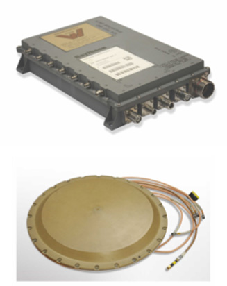
AutonomouStuff kitted out two standard Lincoln MKZ sedans for demonstration drives at the Beijing conference, with one technician completing each vehicle in about three hours — a task that would normally take a team of workers up to six weeks. The two Lincolns then drove simultaneously, driverless, around a test track.
The technology has been developed to be transferrable to other vehicles. Models already demonstrated include the Ford Fusion, a street-legal golf-cart-type electric vehicle called the Polaris GEM, and an off-road Ranger buggy platform.
AutonomousStuff presents the Apollo kit at the Baidu developer’s conference in April. (Photo: AutonomousStuff)
How It Works
Each car is modified by adding lasers, camera, radar sensors, GPS and inertial measurement unit (IMU), a drive-by-wire computer interface and computer engine.
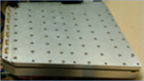
Laser Sensors. A 64-beam lidar sensor on the roof gives a 360-degree field of vision for mapping, and lidar localization algorithms drawing on more than 2.2 million points of data per second generate a point cloud giving distance, angle and intensity values. This data is integrated with data from the GPS and IMU to generate a base map. Two smaller lidar sensors on the front corners of the vehicle provide obstacle detection and tracking.
Rotating four-beam laser sensors with 110-degree view and 200-meter range cover blind spots and facilitate fusing all raw data into one scan. Together, they detect other cars, trucks, bikes, pedestrians and background objects, and generate detailed data on their position, motion and shape. Distance and angular resolution data are used to offset camera and radar data.
Cameras. The platform uses two visible-light cameras mounted on the windshield, relying on laser sensors for nighttime operation. An image-processing chip provides real-time detection of lanes, vehicles and pedestrians, and measures dynamic distances from the vehicle.
Radar. Five radar sensors provide object detection, with various placements around the vehicle, and varying ranges and fields of view. Jointly, they provide a 360-degree bubble around the car.
Navigation. The kits provide GPS navigation combined with a tightly coupled IMU to provide data when GPS is not available.
Together, this provides accuracy to 2 cm, according to the company, when used with a real-time kinematic (RTK) base station; this obviously limits vehicle range. Another option is to use correction data from satellite-based correction services such as TerraStar, yielding achievable accuracies on the order of 4 cm.
Documentation
The aim of the Apollo project is to enable partners and customers to develop their own self-driving systems. The information supplied by Baidu encompasses a complete set of end-to-end instructions to convert a regular car to an autonomous-driving vehicle:
Software Instructions. A set of files that contain:
architecture of the classes and the files within each class.
code instructions for:
coordinate system
third-party libraries
calibration table.
Hardware Documents. Instructions to install the hardware and software for the vehicle include:
Vehicle:
industrial PC (IPC)
GPS
inertial measurement unit (IMU)
controller area network (CAN) card
hard drive
GPS antenna
GPS receiver
Software:
Ubuntu Linux
Apollo Linux kernel
Hardware reference guides:
vehicle
IPC
GPS
CAN card
https://youtu.be/eiSfP-Rn6n4
Manufacturers
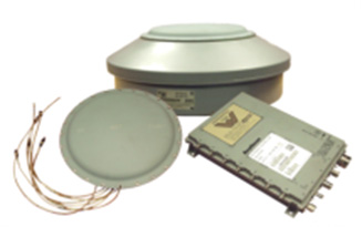
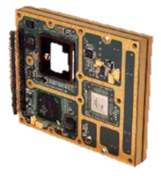
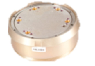
The AutonomouStuff Apollo kit incorporates a choice, depending on user needs, of a selection of NovAtel GNSS receivers, including the ProPak6 GNSS receiver and the SPAN-IGM-A1 GNSS+IMU combined system, IMUs such as the IMU-ISA-100C incorporating Northrop-Grumman Litef GMBH’s inertial measurement technology, and antennas such as the GNSS-703-GGG-HV high vibration triple-frequency GPS, GLONASS, BeiDou, and Galileo antenna.
A 64-beam Velodyne lidar sensor and 16-beam HDL-16E provide laser data.
The onboard computer system is the AStuff Nebula embedded controller, an IPC powered by an Intel Skylake core i7-6700 CPU. The CAN card used for the IPC is the ESD CAN-PCIe/402.
At the Baidu Create conference in Beijing, Baidu named NovAtel’s partner, AutonomouStuff, as a member of its autonomous driving ecosystem, Project Apollo.
Project Apollo has been initiated to provide an open, comprehensive and reliable software platform for Baidu’s partners in the automotive and autonomous driving industries. Partners can use the Apollo open software platform together with the reference hardware platform to accelerate development of their customized autonomous vehicle solutions.
Based on their extensive experience in autonomous system development, AutonomouStuff will provide the “Apollo Kit” to Baidu Apollo partners. The Apollo Kit includes the vehicle — a Lincoln MKZ with by-wire kit installed — and all hardware, software and services required for an Apollo partner to quickly begin developing their autonomous vehicle.
Accurate and reliable positioning is essential to any autonomous system. NovAtel SPAN GNSS/INS products will provide position, orientation and time as a critical component of the Apollo Kit.
“NovAtel is proud to support Baidu and Project Apollo with our high-precision SPAN GNSS+INS positioning solutions,” said Allan MacAulay, business development manager for NovAtel’s Safety Critical Systems Group, who was at the event in Beijing. “We were thrilled to be included in the off-the-shelf, ready-to-use 1.0 reference vehicle and hardware and Apollo Kit announcements by Baidu and AutonomouStuff at Baidu Create. Our technology is a key component on various Baidu autonomous and mobile mapping vehicles, demonstrating our extensive, long-standing support for Baidu and capability in the autonomous driving space.”
“This is a revolutionary movement that will have a major impact on the way developers utilize technology in the future,” said AutonomouStuff CEO Bobby Hambrick. “Apollo is a breakthrough. What used to take decades can now be available in one single day. NovAtel’s reliable GNSS/INS positioning technology is vital to accelerating autonomy development, and as our long-term partner, we are delighted to extend our collaboration to the Apollo Kit. The relationship between Baidu and AutonomouStuff, where NovAtel provides a key technology, is going to change the industry significantly.”
In early 2015, NovAtel took an important step towards delivering positioning solutions to the automotive and autonomous driving industries for serial production by forming a specialized Safety Critical Systems Group.
The group comprises highly skilled engineers with backgrounds in functional safety, as well as all aspects of GNSS and Inertial Navigation Systems technology. The Safety Critical Systems Group is focused on creating positioning products that will meet the exceptional performance and safety requirements of autonomous vehicles at the necessary production volumes and the required price point.
NovAtel’s OEM7 v7.03.00 firmware is now available on all OEM7 receivers. The OEM7700, OEM719 and OEM729 can be updated to the 7.03.00 firmware, which supports new features like the SPAN Land Vehicle technology, direct inertial measurement unit (IMU) connections and tracking of the NavIC Indian regional satellite system on the L5 frequency.
The SPAN Land Vehicle feature provides performance benefits specifically for extended loss of GPS signals, robust alignment routines and improved attitude performance for fixed-wheel land vehicle applications. During extended periods of GNSS outage, typically in low-dynamic operating environments or in dense urban canyons, the SPAN Land Vehicle feature optimizes integrated GNSS+INS performance to maintain accurate position, velocity and attitude.
To achieve this, NovAtel uses intelligent vehicle dynamics modeling and its patented Antenna Phase Windup Technology. Intelligent vehicle modeling identifies IMU errors in the integrated GNSS+INS system that accumulate after extended GNSS outages and reduces the impact of those errors within the SPAN solution.
NovAtel’s Antenna Phase Windup technology is used to sense changes in direction and, when combined with intelligent vehicle modeling, corrects for IMU errors in attitude (roll, pitch, yaw).
Users can now connect SPAN enabled OEM7 receivers directly to the ADIS-16488 and Epson G320N IMUs using an SPI interface, and to the STIM300 IMU using RS422, without the need for an interface card.
OEM7 receivers with NavIC L5 frequency tracking enabled will be able to access the test signals of the Indian Regional Navigation Satellite System (IRNSS) before it becomes operational (targeted for early 2018).
MarketReports.biz has published a detailed market research study focused on the GNSS Market across the global, regional and country level.
The GNSS Market 2017 report provides a 360-degree analysis of the market from the point of view of manufacturers, regions, product types and end industries.
The research report analyses and provides the historical data along with current performance of the global GNSS industry, and estimates the future trend of GNSS market on the basis of this detailed study. The study shares “GNSS Market” performance both in terms of volume and revenue.
Companies mentioned include Harxon Corporation, NovAtel, Trimble, Tallysman, JAVAD GNSS, Stonex, Sokkia, Spectracom and Leica Geosystems.
In my April column, I introduced the basic concepts behind GPS anti-jam technology, along with a bit of history around its evolution. I knew this was a popular topic, but I didn’t anticipate the enormous amount of positive correspondence I’ve received since, including many inquiries about where to buy this technology and who is entitled to have it.
So this month we return to the controlled reception pattern antenna (CRPA) topic, to look specifically at the major suppliers of GNSS anti-jam technology in a bid to help you select the best fit for your requirements.
As mentioned in April, CRPAs can trace their roots back to military radar developments in the 1970s and 1980s. It’s no surprise, then, that the main players in the CRPA market tend to be large defense primes. But there are many smaller companies, universities and research institutions that also play in the CRPA arena these days.
What about export?
When GNSS jamming was a little-known military problem, the situation was simple: anti-jam was a military technology for military applications only. Later, as GPS evolved into a dual-use technology, critical infrastructure and civilian applications brought a new demand for anti-jam in non-military domains.
Confusion then abounded about who exactly is entitled to make use of anti-jam technology. There are two distinct factors here: security classification, and export control. Let’s clear these up.
Security classification is simple: If a product is classified, it is only available to customers who hold the appropriate level of security clearance. Usually it is the performance and vulnerabilities of a product that would attract a classified status. As you might expect for in-service military products, the military would not wish everyone to know the performance and weaknesses of its deployed technology. This is why many datasheets for CRPAs omit performance information.
The second issue is export control. This, of course, varies by country. In the U.S., a CRPA developed towards a defense program is likely to have International Traffic in Arms Regulations (ITAR) restrictions attached to it. In Canada, CRPAs are subject to the Controlled Goods Program. In the UK, CRPAs sit on the “dual-use” export control list, which recognizes that CRPAs have both military and non-military application. An export license is usually required.
Before I go any further, a little disclaimer: I am not making any product recommendations in this article. There are many things to consider when choosing anti-jam technology, and you should always consult a navigation warfare expert and carry out appropriate evaluations prior to choosing a product. You should also seek guidance from your own government regarding any restrictions on export or import.
With that out of the way, let’s look at the offerings of a few suppliers. This is by no means a complete list, but I did manage to catch up with a few of the major players to ask them about their anti-jam technology offerings.
NovAtel
I spoke with Peter Soar, business development manager, Military and Defence, at NovAtel about NovAtel’s offerings.
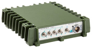
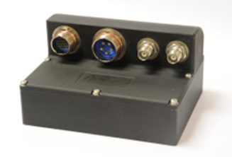
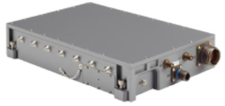
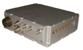
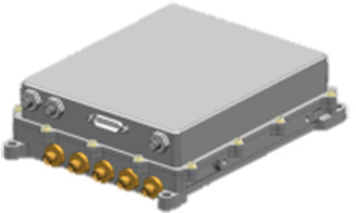
Peter Soar: “The GAJT-710 series are retrofittable GPS anti-jam products that combine a seven-element controlled reception pattern antenna (CRPA) and the antenna electronics in a single unit. The GAJT-AE-N is a GPS anti-jam antenna electronics system that supports a separated four-element antenna.”
Photo: NovAtel
Photo: NovAtel
Photo: NovAtel
Main features: “All three products protect the GPS L1 and L2 bands simultaneously, and are suitable for military (SAASM) receivers as well as open-signal receivers, normal civil receivers and ‘survey grade’ receivers. The wideband design means that the units are ready for M-code. In the GAJT-710, there are seven antenna elements for up to six independent nulls on both frequencies, and the GAJT-AE-N supports four antenna elements, for up to three independent nulls. All products use space-frequency adaptive processing for increased degrees of freedom. System messages provide an indication of jamming presence, even when the nulling is defeating the jamming.”
Intended market: “GAJT-710ML is optimized for land use, while GAJT-710MS is used for maritime and littoral applications. Both types are currently in use on mobile platforms and fixed installations. The GAJT-AE-N is optimized for smaller platforms such as unmanned air vehicles, and is currently in use on a variety of platforms. GAJT products have been shipped to customers in 16 countries to date.”
Example customers: “The GAJT-700ML (a predecessor to the 710ML) was selected for trials by the Canadian Army through the Build in Canada Innovation Program, with exercises performed on the Artillery Observation Post Vehicle (LAV III OPV). Both GAJT variants were selected for field testing by the U.S. Army Communication-Electronics Research Development and Engineering Center (CERDEC) through the U.S. Army Rapid Innovation Fund. The United States Naval Observatory (USNO) selected the GAJT-710ML to satisfy a requirement at sites throughout the Department of Defense Information Network (DoDIN). The GAJT-AE-N is deployed on the Schiebel Camcopter S-100, and was also selected for testing on the M777C1 Howitzer by the Canadian Army.”
Situation with regards to export: “All GAJTs are designed and built in Canada. As such, they are subject to the Controlled Goods Program of Canada, but they are free from ITAR for non-U.S. customers.”
Raytheon UK
Some Raytheon products were mentioned briefly in the April column; I caught up with Alan Wright, business development executive, Force Protection, to get the latest information.
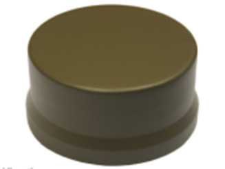
Alan Wright: “Raytheon UK offers a range of anti-jamming products ranging from high-performance products with multiple-element CRPAs to low size, weight and power products. Our current product lines utilize either analog or digital technologies to suit specific end-user requirements.”
Product
Image
Key Features
GAS-1
Analog technology, 7 antenna elements, switchable L1/L2 protection, minimal quiescent time delay, nulling, J/N, M-code signal bandwidth, AE/antenna integrated variant, fiber optic output variant.
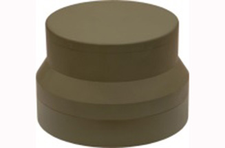
Digital technology, 5 antenna elements, simultaneous L1/L2 protection, low size, weight & power, STAP, nulling, J/N, direction finding, anti-spoof, jamming flag, M-code signal bandwidth.
Landshield
Digital technology, integrated 4-element antenna, simultaneous L1/L2 protection, low size, weight and power, STAP, nulling, J/N, direction finding, anti-spoof, jamming flag, M-code signal bandwidth, switched antenna variant.
MiniGAS
Analog technology, integrated 4-element antenna, simultaneous L1/L2 protection or L1 with L2 passthrough, low size, weight and power, minimal quiescent time delay, nulling, jamming flag.
MicroGAS
Analog technology, integrated 2-element antenna, simultaneous L1/L2 protection, very low size, weight and power, minimal quiescent time delay, nulling.
Intended market: “With over 25 years’ experience, Raytheon UK is a world leader in the development, production and supply of GPS Anti-Jamming (GPS-AJ) systems to the majority of the world’s military forces (including the U.S. DoD and UK MOD), with solutions developed and certified for air, maritime and land applications. Raytheon UK has designed and manufactured in excess of 10,000 GPS anti-jam units for the worldwide market.”
Situation with regards to export: “GAS-1, ADAP and SAS are subject to U.S. ITAR restrictions. Landshield, MiniGAS and MicroGAS are free from ITAR and subject to UK export control.”
Rockwell Collins
I spoke with Al Simon, business development for navigation products/solutions, to get the latest on Rockwell Collins’ offerings. Rockwell’s portfolio includes some CRPA products aimed specifically at weapons. Al kindly provided the following table to summarize:
Product
Image
Platform
Key Features
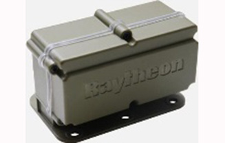
Integrated GPS Anti-Jam System (IGAS)
Weapons (Embedded)
GPS receiver + AJ, nulling and beamforming, spatial, 20 in3, <2 lbs, up to 4 RF antenna inputs, 90+ dB J/S performance *, GPS (simultaneous L1 & L2), path to M-code
Strategic Anti-Jam Beamforming Receiver (SABR)
Weapons (Embedded)
GPS receiver + AJ, nulling and beamforming, STAP, 46 in3, <3 lbs, up to 7 RF antenna inputs, 120+ dB J/S performance*, GPS (simultaneous L1 & L2), path to M-code
NavStorm+
Weapons
Nulling, spatial, 6.9 in3, <.6 lbs, up to 5 RF antenna inputs, 20,000 G shock, 90+ dB J/S performance*, GPS (simultaneous L1 & L2), path to M-code
NavFire
Weapons
Nulling, spatial, 2 in3, <.2 lbs, 1 or 2 RF antenna inputs, 25,000 G shock, 85+ dB J/S performance*, GPS (L1 or L2), path to M-code
DIGAR-200
Airborne, Maritime, Ground
Nulling and beamforming, spatial, 218 in3, <11 lbs, up to 7 RF antenna inputs, 110+ dB J/S performance*, GPS (simultaneous L1 & L2), path to M-code
DIGAR-300
Airborne, Maritime, Ground
Nulling and beamforming, STAP/SFAP, 69 in3, <5 lbs, up to 7 RF antenna inputs, 125+ dB J/S performance *, GPS (simultaneous L1 & L2), path to M-code
Small Platform AJ (Pre-Production)
Ground, Airborne
Nulling and beamforming, STAP/SFAP, 45 in3, <3 lbs, up to 7 RF antenna inputs, 95+ dB J/S performance*, GPS (simultaneous L1 & L2), path to M-code
STAP (Space Time Adaptive Processing); SFAP (Space Frequency Adaptive Processing)
* Beamsteering mode. Actual performance is classified
Situation with regards to export: All listed products are unclassified, but are subject to U.S. ITAR restrictions.
Roke Manor Research
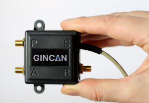
This column wouldn’t be complete without a few words on my own organization. Roke has been developing anti-jam CRPAs since the 1980s, but rarely offers its own products. Typically Roke develops bespoke anti-jam and anti-spoof technology for other defense organizations, including for some products already listed above. Examples of bespoke developments for more specialist markets include Gincan and the Helium antenna.
Photo: Roke
Photo: Gincan
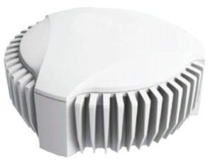
Main features: Both these products are aimed at the commercial civilian market, but do also have defense interest. The Gincan is a very basic low-cost CRPA, with just two antenna elements. The Helium is a conical spiral design, using four antenna elements, and is primarily aimed at protecting GNSS in critical infrastructure. The Helium has excellent low-elevation performance. Both antennas feature very low latency, making them particularly suitable for timing receivers.
Intended market: The Gincan is primarily aimed at providing a basic level of anti-jam capability to the automotive mass market, including cars and trucks, but also has been adopted by some lightweight UAV platforms. The Helium is aimed directly at timing receivers for critical infrastructure, including mobile base stations, digital TV networks, stock exchange and financial institutions, and power and utility grids.
Example customers: Gincan has been delivered to 42 countries, with a mixture of commercial, defense and national security customers. Helium is a relatively new product, and is being trialed on infrastructure in two countries.
Situation with regards to export: Both products are unclassified and suitable for commercial use. They are subject to UK export control as dual-use items, and are ITAR-free.
Others
There are many other suppliers of CRPA technology — unfortunately, too many to cover in this column. Mayflower Communications offer a good range of CRPA products in the form of their NavGuard range. Some other suppliers include Cobham Antenna Systems, BAE Systems Rokar, Thales, Harris Corporation, L-3 Interstate Electronics and Lockheed Martin. I encourage you to contact these companies for the latest information if you are contemplating a CRPA product. If you’re a CRPA supplier and I’ve missed you, please feel free to post a link to your products in the comments section below.
So, that was a bit of a whirlwind tour through some of the products currently around. CRPAs come in all shapes and sizes, and they all have their own particular characteristics and subtleties.
I conclude by reiterating my earlier point. Always conduct a threat analysis, seek the help of a navigation warfare expert if necessary, and properly evaluate your choices. Happy choosing!
SPAN Land Vehicle optimizes integrated GNSS + INS performance for land vehicles during periods of extended GNSS outage, in low dynamic operating environments, or in dense urban canyons. SPAN Land Vehicle ensures that accurate position, velocity and attitude is maintained during such difficult operating environments.
NovAtel uses intelligent vehicle dynamics modelling and its patented Antenna Phase Windup technology to achieve the exceptional performance of SPAN Land Vehicle. The intelligent vehicle modeling identifies inertial measurement unit (IMU) errors in the integrated GNSS + INS system that accumulate after extended GNSS outages, and reduces the impact of those errors within the SPAN solution. NovAtel’s Antenna Phase Windup technology is used to sense changes in direction, and when combined with intelligent vehicle modelling, corrects for IMU errors in attitude (roll, pitch, yaw).
SPAN Land Vehicle performance can be enhanced even further by adding an external sensor such as a Distance Measurement Instrument (DMI), dual antennas or any other external position, velocity or attitude input. It is available on NovAtel’s entire line of SPAN supported IMUs.
NovAtel, the OEM supplier of high-precision GNSS positioning technology, unveiled its Oceanix Nearshore correction service at the Ocean Business show in Southampton, U.K.
Oceanix Nearshore, a subscription-based GNSS correction service for Precise Point Positioning (PPP), provides exceptionally reliable subdecimeter positioning for marine applications such as dredging, hydrographic survey, mapping and coastal patrolling.
The robustness of Oceanix infrastructure sets it apart from the competition. Oceanix precise corrections data is generated utilizing a network of over 80 strategically located GNSS reference stations globally.
Oceanix’ high-rate corrections ensure the full accuracy of carrier phase is gained for enhanced solution accuracy. Oceanix corrections are delivered via geostationary satellites over L-band directly to the enduser, providing reliable high accuracy positioning worldwide.
“NovAtel is in the unique position to have control over the entire PPP data generation process as well as the positioning algorithms that drive GNSS receiver performance, delivering the best user experience for our marine customers,” said Miguel Amor, chief marketing officer for Hexagon Positioning Intelligence. “With the launch of Oceanix Nearshore, our customers now have the ability to obtain not only world-leading GNSS technology, but also a truly robust correction service and integrated support all from a single vendor.”
Oceanix offers multiple subscription durations so that our clients can obtain the service that best fits with the needs of their application. Driven by the NovAtel CORRECT positioning engine, Oceanix Nearshore delivers 4 cm horizontal and 6 cm vertical accuracy rms. Algorithms proprietary to NovAtel CORRECT greatly enhance the accuracy and recovery speed from GNSS signal interruptions.
GeoMax has updated the firmware on its Zenith35 Pro GNSS receiver, which was introduced in November 2016.
The update is for NovAtel’s OEM7 Measurement Engine built into the receivers. Update OM7MR0102SN0005 addresses a real-time kinematic (RTK)-network connection issue preventing reception of corrections when connecting to selected NTRIP networks in some countries.
Note that the receiver’s onboard firmware version remains unchanged at 2.01.
The compact and fully ruggedized Zenith35 Pro has 555 channels. Its multi-constellation and multi-frequency capability supports all satellite systems today and in the future.
The Zenith35 Pro incorporates “Tilt&Go” functionality that allows users to measure inaccessible points. This significantly increases efficiency in the field, since leveling time is eliminated. Tilt and compass values for each measurement are stored for quality control and documentation purposes.
The unit is IP68-rated for water and dust, and is shock protected.
NovAtel has launched its OEM7 7.200 version firmware. Version 7.200 firmware introduces powerful new positioning functionality including the company’s Interference Toolkit (ITK).
The ITK allows users to detect and mitigate intentional interference such as the adversarial jamming of GNSS signals, as well as the unintentional interference from external sources. The new RTK Assist corrections service assures continued high-accuracy positioning when signals from a real-time kinematic (RTK) network are unavailable or disrupted.
With the ITK, NovAtel’s OEM7 customers can auto-detect and report in-band radio frequency (RF) interference so that any interference adversely affecting their receiver’s positioning performance can be quickly nullified.
In combination with the 7.200 firmware launch, NovAtel is introducing NovAtel Connect 2.0, the latest version of its PC-based graphical user interface (GUI). Running on Microsoft Windows 10, NovAtel Connect 2.0 offers significant user enhancements including features to optimize ITK functionality.
Firmware version 7.200 expands NovAtel’s proprietary correction service capabilities with the introduction of two new subscription-based offerings:
TerraStar-L 40-centimeter correction service. This Precise Point Positioning (PPP) correction service delivers exceptionally robust 40-cm-level positioning performance at an entry-level price point, anywhere on earth without the need for a base station. With corrections derived from the fully redundant TerraStar network infrastructure, the new service is designed for broad accuracy positioning applications such as agriculture, construction or GIS.
RTK Assist correction bridging service. This globally available service allows users to maintain RTK-level accuracy when RTK corrections are disrupted. RTK Assist uses multiple geostationary satellites to beam corrections directly to the receiver to bridge outages that can occur with local RTK networks.
“Developing products that not only deliver high-precision, high-accuracy positioning, but also assure our customers’ position is central to our mission at NovAtel,” said NovAtel’s director of product management, Neil Gerein. “The release of OEM7 firmware version 7.200 reflects our company’s commitment to continually enhance positioning performance, whether by expanding receiver capabilities, or in mitigating unintentional or intentional interference as reflected with the capabilities of our new Interference Toolkit.”
For more details on all 7.200 firmware capabilities, see this PDF.
Two new topic areas and presentations have been added to this Thursday’s free webinar on Signal Interference: Detection and Mitigation.
The speakers will explore anti-jamming protection with controlled radiation pattern antennas (CRPAs) and with dual-polarized antennas. The latter topic is also the cover story for the February issue, which demonstrated a significant improvement in positioning accuracy and robustness against interference with a dual-polarization approach: a gain in terms of C/N0, particularly for low-elevation angle satellites and valuable in urban environments.
Headshot: Kirk Burnell
Kirk Burnell from NovAtel joins the Feb. 2 panel to present “How to deliver assured positioning, navigation and timing in GNSS-compromised environments.”
He will look at applications that stress the importance of high-reliability PNT. Compromised GNSS signals due to unintentional interference is of great concern, but intentional interference due to jamming is much more insidious. Anti-jamming protection via controlled reception pattern antenna (CRPA) technology is now available to a wide range of users. A brief explanation of the technology will be followed by a few use-cases where CRPAs have been deployed in a variety of applications.
Burnell, Core Cards Product Manager for NovAtel, has worked at the company since 2015. With an education in survey engineering, Kirk has been working with precision GNSS system designers and integrators in both support and product management capacities for more than 20 years.
Headshot: Matteo Sgammini
Matteo Sgammini of the German Aerospace Center (DLR) will talk about work with dual-polarized antennas: the principles of operation of such an antenna array and how one performed in real-world jamming and non-jamming scenarios. This ION GNSS+ 2016 presentation became the cover story for GPS World’s February issue.
Innovation editor Richard Langley writes in his introduction to the February column, “All GNSS satellites transmit RHCP [right-hand circularly polarized] signals and therefore most GNSS receiving antennas are designed for such signals. However, a funny thing can happen to a satellite signal on the way to a receiving antenna. If the signal bounces off a nearby structure or the ground or the sea surface, its polarization is modified and it will become LHCP [left-hand circularly polarized] or a combination of the two polarizations.
“A primarily LHCP antenna can capture a significant portion of the energy in such a RHCP signal and could provide a strong response to a reflected signal when the line-of-sight signal is missing or very weak. So, there could be a benefit in having a dual-polarized antenna to improve positioning capability in marginal situations. Furthermore, jamming signals can be of arbitrary polarization and a dual-polarized antenna array with beamforming capability could better separate and mitigate such interference.”
February cover story. Photo: GNSS
Researchers at the DLR equipped a GNSS receiver with a diversely polarized antenna array to combine signal processing in the spatial and in the polarization domain. Tests show a significant improvement in receiver robustness against interference compared with the general single-polarization case.
The carrier-to-noise-density ratios of the line-of-sight components are improved since the receiver can use the power present on the left-hand circularly polarized channels, particularly for satellites with low elevation. Interference mitigation improves due to the possibility of filtering in the polarization domain and the additional number of available degrees of freedom.
Sgammini received a Masters degree in electrical engineering from the University of Perugia, Italy and now works at the Institute of Communications and Navigation, DLR. He is currently pursuing a Ph.D. in electrical engineering with research interests in interference mitigation techniques for GNSS. His research activity includes adaptive filtering, array signal processing and estimation theory for GNSS.
As the number of GNSS signals being tracked increases, so does the potential for interference to dismiss the performance gains of using those additional signals.
To maximize performance and efficiency, prepared PNT users need their equipment to be able to detect when interference is present and mitigate it.
Developers, integrators and users need mitigation tools to protect and preserve GNSS measurement quality, maintaining high-quality multi-frequency multi-constellation positioning performance, even in challenging RF environments. This is essential particularly on the integration journey, especially during prototyping and when encountering unforeseen interference events in field testing, in order to produce fully successful integrated products.
The one-hour webinar also will include a follow-up Q&A session with the speakers. Burnell and Sgammini join Patrick Casiano of NovAtel and Rick Hamilton of CGSIC on the speaker panel. Casiano will present an Interference Toolkit that measures RF spectrum levels and allows the user to apply mitigation tools to protect and preserve GNSS measurement quality. Hamilton will explain the proliferation of jammers, aspects of illegal use, coordinated government response to interference events, and regulations to prohibit manufacture, import, export, sale and use of jammers.
NovAtel Inc. is showcasing its high precision positioning technology as part of AutonomouStuff’s “Roadmap to Autonomy” exhibit at the 2017 Consumer Electronics Show (CES), Jan. 3-8 in Las Vegas. The exhibit is located at the MGM Grand in the Skyline Terrace Suite.
AutonomouStuff provides research and development platforms for the safe and reliable testing of automation technologies.
It uses NovAtel’s exceptionally robust SPAN GNSS + Inertial (INS) technology to provide the highly precise, continuous 3D positioning necessary to evaluate robotic and autonomous solutions for autonomous applications.
NovAtel’s SPAN technology combines a high-performance Global Navigation Satellite System (GNSS) receiver with an Inertial Measurement Unit (IMU) to deliver deeply-coupled centimeter-level positioning. SPAN provides robustness against short GNSS outages, using IMU updates to bridge the positioning solution. SPAN also provides high data rate position, velocity and attitude (pitch, roll, heading) updates to capture the full real-time motion profile of a vehicle. Widely deployed in the automotive R&D space, SPAN supports applications ranging from autonomous navigation to V2X systems, where it is utilized to provide a source of vehicle ground truth.
As a committed technology partner, NovAtel has worked closely with AutonomouStuff to optimize SPAN for AutonomouStuff’s vehicle perception kits. As a result of these efforts, AutonomouStuff is able to offer three different levels of positioning performance — “good, better, best” — based on the grade of IMU selected.
“We are always excited to work with the team at NovAtel and cannot wait to show off their ‘good, better, best’ SPAN GNSS options for autonomy in our suite at CES,” said AutonomouStuff CEO Bobby Hambrick. “Their solutions are a significant piece of autonomous research and development. With three kit options, there is something for everybody. We’ve done the work for you, allowing you to choose which kit is best for you based on your accuracy needs and price range.”
The collaboration with AutonomouStuff is reflective of NovAtel’s commitment to the development of fully autonomous vehicles for a wide range of industries. In May 2016, NovAtel announced the formation of a new Safety Critical Systems (SCS) Group, tasked with developing functionally safe GNSS positioning products that will meet the exceptional performance and safety requirements of autonomous vehicles.
“Our team made significant progress in 2016 towards product definition, GNSS integrity for automotive applications, and corporate TS 16949 compliance,” said Jonathan Auld, Director of the SCS Group at NovAtel. “As the world leader in high precision GNSS technology for more than 20 years, NovAtel is leveraging its extensive experience developing safety critical systems for the aviation industry to meet the future safety thresholds required for driverless cars.”
AutonomouStuff and NovAtel representatives will be available in the MGM Grand Skyline Suite during the CES to answer customer questions. To set up a meeting with the NovAtel SCS team at CES 2017, attendees can contact Allan MacAulay, Business Development Manager, SCS ([email protected]).