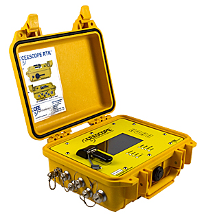
The NovAtel OEM6 GNSS receiver card used in the CEESCOPE echo sounder has been replaced with NovAtel’s latest low-power, high-performance OEM729 receiver.
With 555 channels, the new GNSS option brings a vast increase in available channels for future-proofing, improved interference rejection and better performance in challenging environments, the company said.
The TerraStar L-Band support remains.
The OEM729-equipped CEESCOPE is available with a built-in UHF radio modem and direct Ethernet connectivity to the GNSS receiver for NTRIP cell-phone real-time kinematic corrections.
NovAtel has integrated its high-precision positioning engine and correction services with automotive-grade multi-frequency GNSS chipsets from STMicroelectronics: specifically, the Teseo APP (Automotive Precise Positioning) and Teseo V.
The integration demonstrates possibilities for vehicle localization solutions. NovAtel is part of Hexagon’s Positioning Intelligence Division.
STMicroelectronics’s Teseo APP and Teseo V provide multi-frequency GNSS data for PPP (precise point positioning) and RTK (real-time kinematic) for accurate positioning capabilities.
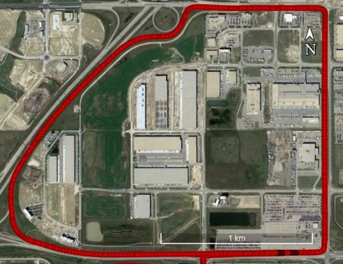
The Teseo V SBAS and Teseo V NovAtel PPP tests took place in a light urban environment. (Image: NovAtel)
NovAtel’s positioning engine combines the GNSS measurements from these chipsets with inertial measurement unit (IMU) data and Hexagon PPP correction services on the demonstration platform to deliver centimeter-level PPP positioning solutions in real time.
“Working closely with STMicroelectronics using their Teseo APP chipset allowed us to innovate and speed up the development of our assured positioning solution tailored specifically for safe positioning of autonomous vehicles,” said Jonathan Auld, VP Engineering and Safety Critical Systems from NovAtel.
NovAtel’s positioning engine architecture enables a flexible integration with different GNSS receiver chipsets, IMUs and processor environments, providing automotive manufacturers with additional flexibility when it comes to selecting components and subsystems of advanced driver assistance systems (ADAS) and autonomous driving solutions.
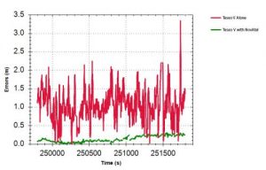
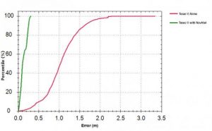
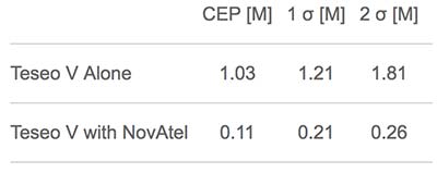
Test results: Horizontal position errors. Teseo V alone is shown in red, Teseo V + NovAtel in green. Test results: Horizontal cumulative error distribution. Teseo V alone is shown in red, Teseo V + NovAtel in green. (Chart: NovAtel)
Test results: Horizontal cumulative error distribution. Teseo V alone is shown in red, Teseo V + NovAtel in green. (Chart: NovAtel)
The positioning engine is being developed to ASIL-B standards according to ISO26262 and will include a proprietary GNSS integrity solution to ensure safe positioning within defined protection limits that are tailored to the customer’s application requirements.
“NovAtel’s choice of the automotive-quality ASIL-capable Teseo APP to integrate with their GNSS positioning engine is enabling them to develop a world-class safety-critical positioning offering to the automotive industry,” said Antonio Radaelli, Director, Infotainment Business Unit, STMicroelectronics.
NovAtel technology continues to be an integral part of the connected and autonomous car ecosystems, including academic research, industry development and real-life applications. The company’s automotive positioning solution includes automotive GNSS antenna technology, GNSS/INS positioning engine, and global correction services.
Q: What are the key criteria in selecting a GNSS antenna for a particular application?
Jerry Freestone, Chief Engineer, Antennas and Anti-Jam, NovAtel
A: Performance, size and cost. Size and cost are easy for the integrator to assess; determining the necessary antenna performance to achieve the desired system-level performance is difficult to evaluate. Obtaining the complete GNSS solution from a single source is ideal; vendors that sell both antennas and receivers will generally understand the minimum system-level performance their solutions can provide for a given application and deliver the optimized solution to meet all three criteria.
Brandon Oakes, Director, North American Sales and Marketing, OriginGPS
A: Antenna selection for GNSS applications must consider performance, size and cost. Successful GNSS deployments start with the antenna selection in mind rather than waiting until the end and letting other design constraints drive the antenna selection. Patch antennas are always our preferred solution due to polarization, robustness and our patented integration method that minimizes bandwidth shift. Chip antennas are attractive due to their size, but consideration must be paid to ground-plane size and detuning.
Satellite operator Iridium asked the Federal Communications Commission (FCC) in April 2017 to modify its license to add a new class of ground stations called Certus for expanded terrestrial, maritime and aeronautical operations.
Iridium’s 66-satellite constellation provides, in addition to mobile communications signals, the Satelles time and location service: microsecond timing accuracy and 20- to 50-meter unaided position accuracy worldwide (see the “Innovation” column, July 2017 GPS World).
GPSIA. The GPS Innovation Alliance (GPSIA) commented in September, “GPSIA seeks to ensure that radio navigation satellite service (RNSS) receivers operating in the 1559–1610 MHz band are adequately protected from out-of-band emissions (OOBE) generated from the new Certus mobile Earth station (MES) terminals that will operate on the second-generation Iridium satellite system.
“GPSIA and Iridium are actively engaged in constructive discussions regarding the adequacy of that protection, but no final resolution has yet been reached. [….]
“In the unlikely event that GPSIA is unable to reach an agreement with Iridium, it asks the commission to impose limitations on the operation of Certus terminal devices to protect GPS/RNSS operations in the 1559–1610 MHz band at a level equivalent to what terrestrial terminals in the same and other frequency ranges provide at –95 dBW/MHz.”
Iridium Certus infographic.
Hexagon. Hexagon, the parent company of GPS manufacturer NovAtel, commented on Jan. 8, “Certain statements in the modification application regarding output power and amount of terminals to be deployed cause great concern regarding the unimpeded operation of radio navigation satellite service (RNSS) receivers. The application does not include enough information to simulate the impact properly.
“Hexagon politely requests that the FCC will exercise the same due diligence [as] during previous modification applications close to the RNSS bands (for example docket 11-109) and establish a technical working group or a similar testing process that ensures unimpeded coexistence of the modified Iridium terminals with the established RNSS systems.”
Documents related to the case can be found here, on the FCC International Bureau website.
Renesas will use NovAtel’s high-performance SPAN tightly coupled GNSS and inertial navigation system (INS) technologies with GNSS correction services for live autonomous vehicles and advanced driver assistance systems (ADAS) demonstrations throughout CES.
SPAN GNSS+INS products provide position, orientation and time solutions that are critical for autonomous applications.
NovAtel’s assured positioning technology not only delivers solutions based on signals from satellite constellations but also uses vehicle behavior modelling, inertial sensor integration and GNSS correction signals to improve accuracy and significantly reduce interruptions in availability.
Image: NovAtel
Renesas relies on NovAtel products to provide high integrity and accurate positioning for autonomous driving, ADAS, connected car feature demonstrations and automotive solutions that will be showcased at CES 2018.
With the commitment to ensure autonomous vehicles have assured positioning solution, a team of engineers formed the Safety Critical Systems Group at NovAtel to meet the exceptional performance and safety requirements of autonomous vehicles at the necessary production volumes and price point required.
Since its formation, the group has made many positive partnerships in the automotive industry.
NovAtel and Renesas are currently collaborating on implementing NovAtel’s high-performance GNSS+INS positioning solution with the Renesas R-Car H3 system-on-chip (SoC). The R-Car H3 is compliant with the ISO 26262 functional safety standard for automotive applications, which aligns with NovAtel’s automotive strategy.
NovAtel has a long history providing industry leading high-precision GNSS solutions that are high quality and reliable. As an ISO 9001 certified company, NovAtel is also developing an extensive product line of receivers, antennas, correction signals, positioning algorithms, sensor fusion solutions and systems that fulfill specific safety requirements of the automotive industry such as ISO 26262.
Q: How will safety issues raised by increasing autonomous traffic — in the air and on roads — affect the GNSS industry?
Sanchit Agarwal, VP, Field Operations, Nearmap
A: Due to increasing autonomous traffic, the GNSS industry will have to adopt the concepts of collective tracking mechanisms in the shared ecosystem. Inherently, all the cars/drones (rovers) will have the sensors to track the traffic “on-the-fly” and make intelligent navigation decisions, but in case of any system malfunction, the collective tracking of devices can facilitate “social” interactions between the rovers. This will serve as an added layer of security in case an autonomous social member goes rogue!
Zak M. Kassas, Assistant Professor, University of California, Riverside
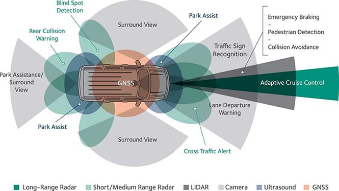
A: Future autonomous vehicles will demand full situational awareness and extremely reliable, accurate and secure navigation systems. GNSS will not meet the stringent demands of these autonomous vehicles. To address the inevitable situations where GNSS signals become unusable (due to attenuation or interference) or untrustworthy (due to spoofing), receivers should be coupled with sensors such as IMUs, lidar and cameras, and exploit the plenitude of ambient signals of opportunity such as cellular, digital TV and Wi-Fi.
Jonathan Auld, VP of Engineering and Safety Critical Systems, Novatel
A: Safety issues raised by increasing autonomous automotive and airborne traffic will escalate the product development standards and performance requirements of GNSS software, hardware, and correction services used. The GNSS industry is challenged to increase accuracy on lower cost platforms by utilizing multi-frequency, multi-constellation, sensor fusion and precise point positioning. To be able to rely on GNSS in auto-guidance applications, the industry also needs to incorporate GNSS integrity functionalities into our products.
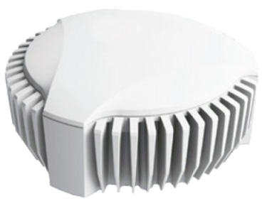
NovAtel’s GPS Anti-Jam Technology (GAJT) has been selected for the United Kingdom’s Type 26 frigates to meet a requirement as part of a protected navigation system.
The frigates are 21st-century warships that will replace the Type 23 frigate as the workhorse of the British Fleet, undertaking the Royal Navy’s three core roles — warfighting, maritime security and international engagement — on the world stage.
GAJT-710MS
GAJT protects GPS-based navigation and precise timing receivers from intentional jamming and accidental interference, ensuring that the satellite signals necessary to compute position and time are always available. It is a commercial off-the-shelf (COTS) product, and comes in versions suitable for land, sea, fixed installations and smaller platforms such as unmanned aerial vehicles (UAVs).
Warships, military vehicles and platforms, networks and timing infrastructure can all benefit from the protection that GAJT provides. There is no need to replace GPS receivers already installed, because GAJT works with civil and military receivers including SAASM and M-code.
The Type 26 frigates of the British Fleet will use NovAtel anti-jam technology. (Photo: BAE Systems)
“The selection of GAJT for the Type 26 frigates is the result of cooperation between Drumgrange, with its proven track record for rapid realisation of demanding defence design tasks, and Forsberg Services, an established navigation systems company and NovAtel dealer whose high quality manufacturing was instrumental to the project,” said Peter Soar, business development manager for military and defence at NovAtel. “GAJT is in use operationally and has been shipped to 16 allied nations around the globe. We are grateful for the rigorous technology selection process conducted which led to this choice.”
NovAtel’s commitment to precise, assured positioning and timing is central to the design of the GAJT antenna. The company’s lean manufacturing techniques and quality processes mean that it can ramp up quickly to meet volume requirements. Reliability is assured by NovAtel’s industry-best low return rate.
Assessing the performance of autonomous systems under real-world conditions requires an ultra-precise ground truth reference against which to benchmark vehicle performance. A GNSS-plus-inertial post-processing software can provide this capability, taking real-time GNSS data — which are subject to outages, obstructions, weather-induced errors and more — from the vehicle and correcting the solution. This can improve meter-level data to centimeter-level, a critical standard for safe autonomous performance. A free webinar on Nov. 30 gives both a high-level overview and close-in details of this process.
Many sub-systems must function flawlessly and interact seamlessly for safe autonomous vehicle performance. Fielding such a vehicle requires rigorous testing, repeated many times; this in turn requires close comparison of the vehicle’s real-time GNSS data to a ground truth of its performance. Post-processing software that combines GNSS with inertial navigation system (INS) data, to bridge GNSS outages common in real-world driving, can provide this capability. Whether the tests are evaluating potential sensor suites, benchmarking their own solutions, or generating high-definition maps, post processing maximizes the accuracy of the solution by processing previously stored GNSS and INS data forward and reverse in time, and combining the results.
Novatel’s Waypoint software package, Inertial Explorer, offers this capability, whether lower-grade or high-end inertial sensors are employed. An examination of the process is afforded in the free webinar, from the converging viewpoints of three speakers:
Steven Waslander, associate professor at the University of Waterloo, heads a project collecting 1,000 km of data in all-weather conditions for a new public road driving dataset focused on autonomous driving challenges. He directs the Waterloo Autonomous Vehicle Laboratory (WAVELab), extending the state of the art in autonomous drones and autonomous driving through advances in localization and mapping, object detection and tracking, integrated planning and control methods and multi-robot coordination.
Terry Lamprecht, director of products at AutonomouStuff, a supplier of components, services and software that enable autonomy, will discuss verifying proper installation, and creating a baseline data set to benchmark against data collected on autonomous vehicles in real-time.
Natasha Wong Ken, product manager at Waypoint, will give a high-level technical overview of post-processing techniques and settings, including forward and reverse processing, tightly vs. loosely coupled, PPP vs. differential, and more.
Registration for the November 30 webinar is free. For those not able to attend the live broadcast, all audio and presentation slide components can be downloaded after air date for viewing at convenience.
Some of the new capabilities explored jointly by NovAtel and AutonomouStuff are covered in the August cover story, Autonomous Assembled.
A new report describes the benefits growers can experience using NovAtel’s TerraStar-C and TerraStar-L precise point positioning (PPP) technology with a SMART6-L GNSS receiver for automatic steering.
The report, “DLG Test Report 6802, NovAtel SMART6L receiver PPP Automatic Steering Test,” was issued by the German Agricultural Society or Deutsche Landwirtschafts-Gesellschaft (DLG).
DLG promotes technical and scientific progress in the agriculture and food sectors. Set up to test equipment and machinery, the DLG Test Center Machinery and Farm Inputs provide impartial information for practitioners.
DLG awards a DLG-APPROVED quality mark to farm machinery that passes a limited test programme within a DLG usability test. Using a Fendt 828 Vario tractor, combined with the Fendt “VarioGuide RTK” steering system and the NovAtel SMART6-L receiver, steering accuracy was tested using both TerraStar-C and TerraStar-L correction services.
NovAtel’s TerraStar-C correction service provides a 5 cm or less (95%) position accuracy, and TerraStar-L provides a 50 cm or less (95%) position accuracy with a 15-cm pass-to-pass accuracy. The DLG test is designed to measure steering accuracy under various conditions as part of the criteria to receive the DLG-APPROVED quality mark.
The DLG test reported that NovAtel’s TerraStar-C correction service achieved 2-3 cm system steering accuracy on an A-B run on an even track at 8 km/h, and a 3.4 cm accuracy at 15 km/h. The long-term accuracy was reported at 3-4 cm over a 24-hour period. Also, the pass-to-pass error was less than 3 cm over the duration of an hour.
The DLG test reported NovAtel’s TerraStar-L correction service at 17-18 cm accuracy during an hour A-B run on an even track at 8 km/h, and 10-11 cm accuracy on a contour run at 5 km/h. The pass-to-pass error remained below 15 cm for the duration of the tests.
NovAtel’s SMART6-L was awarded the DLG-APPROVED quality mark after successfully completing the PPP autosteering test.
Esterline CMC Electronics and NovAtel Inc. have entered a new strategic partnership, extending their collaboration in GNSS positioning technology that started in the late 1990s.
The partnership will see NovAtel’s GNSS measurement technology integrated into a new Esterline CMC-designed multi-constellation, multi-frequency chipset for certified aviation use.
The DO-254 Level A certified chipset will allow both companies to develop new GNSS receiver solutions for use in a variety of safety critical applications, including DO-178C Level A certified products designed for commercial aviation, military and unmanned aerial systems (UAS).
Combining the capabilities of NovAtel’s GNSS expertise with Esterline CMC’s aviation and certification experience will allow the companies to bring innovative solutions to the market, meeting the requirements of new and evolving industry standards as the modern age of multi-constellation, multi-frequency GNSS positioning in aviation is ushered in, the companies said.
NovAtel and Esterline CMC plan to combine their resources to deliver competitive solutions with a new standard for excellence in this application space.
“Esterline CMC and NovAtel have a highly successful and growing relationship built on the strengths of both companies often described as ‘1+1 yields 3,’” said John Studenny, director, aviation GPS products at Esterline CMC. “While Esterline CMC Electronics is an acknowledged industry leader with its reliable, dependable, DAL-A certified CMA-5024 and CMA-6024 landing system receivers, our company will usher in a new generation of high-performance Multi-Constellation-Multi-Frequency (MCMF) GNSS products certified to the highest levels, supporting current and new aircraft GNSS precision approach.”
“We are proud to extend our long-standing and successful collaboration with Esterline CMC Electronics,” said Jonathan Auld, vice president of engineering and safety critical systems at NovAtel. “We believe that this partnership will strengthen the technology portfolio of both companies. NovAtel is a major supplier of precise GNSS technology to mission-critical military and civilian UAS, for example, and with this new, certified chipset we will extend our solution portfolio with assured positioning solutions to meet the emerging industry standards.”
The Jawaharlal Nehru Technological University-Hyderabad (JNTU-H) and Hexagon Capability Centre India (HCCI) have established a GNSS laboratory at the Centre for Spatial Information Technology, JNTU-H, reports Telangana Today.
The university is located in Kukatpally, Hyderabad, in the Indian state of Telangana.
The lab is equipped with NovAtel GNSS receivers, antenna, systems, cables and other hardware components. The equipment enables reception, processing, analysis and development of navigational data and applications to augment curriculum for JNTU-H students for research and education.
The establishment of the GNSS lab will also provide an opportunity to the students, scholars and faculty members to carry out research in satellite-based navigation and to develop advanced applications.
HCCI will provide internship to the students with financial support and job opportunities. This provision will not only be for CSIT students, but also for students with geo-informatics background from other constituent units of JNTU-H.
After opening the lab, Michael Kinahan, the software director of Hexagon Positioning Intelligence (NovAtel products division of Hexagon group) discussed various technical aspects of the NovAtel products with the potential of applying high-precision positioning capabilities to solve real-world challenges.
NovAtel’s Kirk Burnell explains how the company can bring you assured positioning through its product line at Intergeo 2017, which took place Sept. 26-28 in Berlin, Germany.
 The NovAtel OEM6 GNSS receiver card used in the CEESCOPE echo sounder has been replaced with NovAtel’s latest low-power, high-performance OEM729 receiver.