Tag: OCX

  • Benefits coming from GPS III constellation

    Benefits coming from GPS III constellation

    That was then. This is now.

    When managed by a new ground control system, GPS III satellites will offer triple the accuracy and eight times the anti-jamming capabilities of the satellites currently comprising the U.S. Air Force’s GPS constellation. Users military and civilian will reap ample benefits.

    Everything changed for space-based positioning, navigation and timing around the world on Dec. 23, 2018. Or maybe it didn’t. The innovations heralded by the launch of the first GPS III satellite will take years more to occur. We tabulate here the advances that Generation Three will bring over GPS-to-date, and review the timeline for their actual arrival.

    While these new capabilities exist — in concept — in space, they can’t be leveraged on the ground (or in the air, or at sea) until a sufficient number of additional GPS III satellites have joined the constellation, and until a new ground control system comes online. This will occur — perhaps — in 2023. At that time the satellites’ talents will be unleashed.

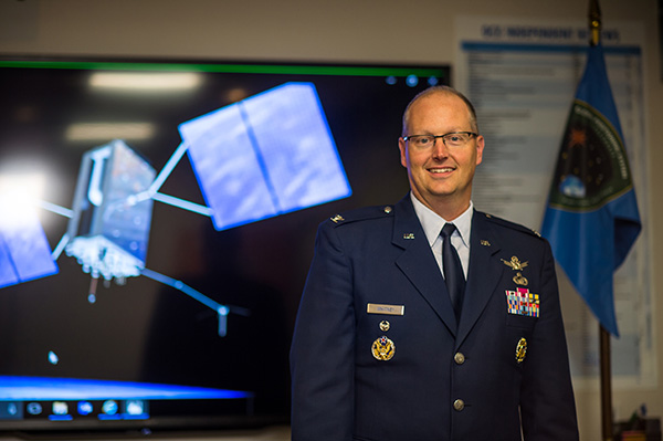
    “As more GPS III satellites join the constellation, it will bring better service at a lower cost to a technology that is now fully woven into the fabric of any modern civilization,” stated Lt. Gen. John Thompson, commander of the U.S. Air Force’s Space and Missile Systems Center and the Air Force’s program executive officer for space.

    The many GPS III upgrades should make the service more reliable and accurate for civilians, more secure against those who want to jam military users, and more cyber-secure for everyone.

    TALKIN’ ‘BOUT OUR GENERATION

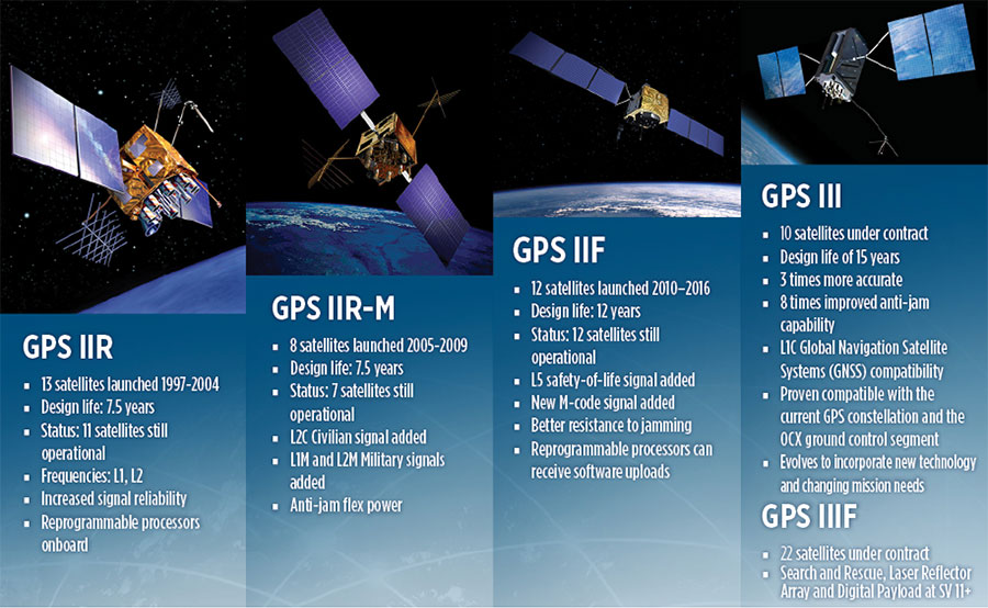
    GPS constellations have grown through six major iterations since 1978. The sixth, GPS IIF, rose during the years 2010 to 2016. Those 12 satellites are all designed to last 12 years. Some of their notable features include the ability to receive software uploads, better jamming resistance and increased accuracy.

    GPS III, the seventh generation, will launch nine more satellites to join SV01 already in space. GPS III SV02 is scheduled to launch in July of this year, SV03 in late 2019, and SV04 in 2020. The final III payload should rise in 2023. From that point on, the follow-on era of GPS IIIF takes over.

    How Long, How Long? “Projections for how long the current constellation will [continue to] be fully capable have increased by nearly two years to June 2021, affording some buffer to offset any additional satellite delays,” reported the Government Accounting Office at the end of 2017. This provided some schedule buffer for launching the first GPS III satellite, but it did not reduce the desire to launch as soon as the booster rocket became available.

    The new birds will introduce new capabilities to meet higher demands of both military and civilian users: once filled out, the GPS III constellation will bring three times better accuracy and up to eight times improved anti-jamming capabilities. Spacecraft life requirement will extend to 15 years, 25 percent longer than the latest GPS satellites and twice the original design life of the oldest satellites on orbit today.

    The new L1C civil signal broadcast by GPS III is an interoperable signal with other international global navigation satellite systems, like Galileo, improving connectivity for civilian users.

    GPS III will eventually actualize full M-code capability — carried aboard the IIR-Ms and IIFs but not yet completely implemented — in support of warfighter operations. GPS III M-code capability exceeds that of GPS IIR-M and GPS IIF.

    GPS III will complete the deployment of the L2C civil signal and the L5 safety-of-life signal capabilities that began with \GPS IIR-M and GPS IIF satellites.

    Finally, GPS III will enact improved integrity: the ability of the satellite to detect and issue alerts on its own reduced accuracy, should that phenomenon ever occur.

    Military Signal Power Up. Encrypted M-code signals will be up to eight times more powerful than currently. This makes them more reliable. but also enables the sats to overcome efforts to jam their signals.

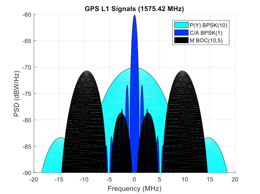
    Other signals also offer increased signal power at the Earth’s surface. L1 and L2: −158.5 dBW for aC/A code signal and −161.5 dBW for the P(Y) code signal. L5 will be −154 dBW.

    Family Features. The most recent generations of the GPS constellation. IIR, IIR-M and III were produced by Lockheed Martin, while IIF was built by Boeing. One GPS IIA satellite is still in operation, at 25 years young (design life was 7.5 years). All satellites carry Harris Corporation payloads. (Graphic sourced from: Lockheed Martin and Boeing Co.)
    Family Features. The most recent generations of the GPS constellation. IIR, IIR-M and III were produced by Lockheed Martin, while IIF was built by Boeing. One GPS IIA satellite is still in operation, at 25 years young (design life was 7.5 years). All satellites carry Harris Corporation payloads. (Graphic sourced from: Lockheed Martin and Boeing Co.)

    L SIGNALS

    L2C, the second open GPS signal, after L1 C/A, has been available from every new GPS satellite since the first IIR-M launch in 2005. L5, the third open GPS signal, became available with the first IIF launch in 2010. Now L1C, the fourth open GPS signal, joins the band, broadcasting from every new GPS satellite, starting with the recent GPS III launch (see First Light).

    The first GPS III satellite is in checkout and testing that could last up to 18 months before it enters service. “After its Dec. 23 launch, GPS III SV01 successfully completed its orbit raising and deployment of all of its antennas and solar arrays. On Jan. 8, the satellite’s navigation payload began broadcasting navigation signals,” said Johnathon Caldwell, Lockheed Martin vice president for navigation systems. “On-orbit testing continues, but the navigation payload’s capabilities have exceeded expectations and the satellite is operating completely healthy.”

    Testing, Testing. Using the Air Force’s Back-to-Basics program, which involved early prototyping and simulations, Lockheed Martin developed GPS III with an approach that involved rigorous quality-build certificates, component testing and system-level testing. The comprehensive requirements verification and validation process ensured more than 30,000 requirements were achieved. The system functional qualification includes the performance verification in multiple environmental tests, including the acoustic, thermal vacuum (TVAC) and electromagnetic spectrum.

    “We consider thermal vacuum the gold standard for testing any satellite before it goes into operations,” Col. Steve Whitney, director, GPS Directorate, wrote in GPS World in December. “It really is putting the craft through the paces. When it goes through the testing, the satellite is on. It is working. It is exposing it to the heat and the cold and the zero pressure while the satellite is functional. The entire thermal vac testing from start to end is about 70 days. Test like you fly. From the time it launches and deployment sequence, we test it like it is real. Minus the shaking, the satellite thinks it is getting launched. Meanwhile, our people are looking at the data and its health. TVAC is a huge milestone for a satellite to go through and come out no issues.”

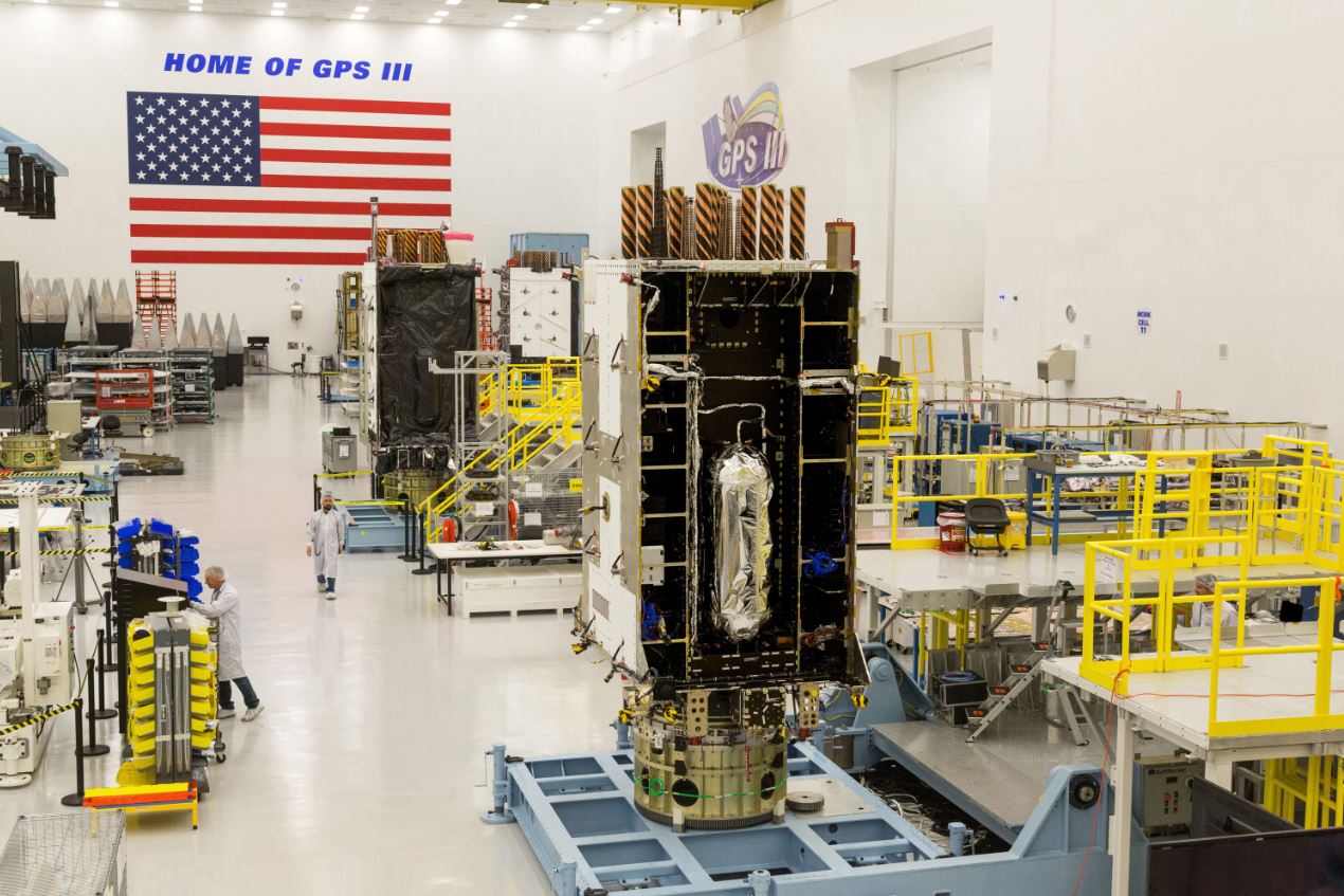
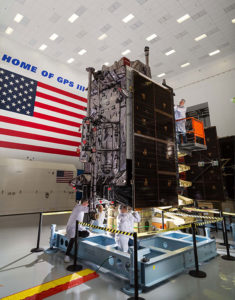
    To date, more than 90 percent of parts and materials for all 10 GPS III satellites have been received from more than 250 aerospace companies in 29 states.

    BRAIN OF THE BUNCH

    THE FIRST GPS III satellite was fully assembled and entered into SV single-line flow when Lockheed Martin technicians integrated its system module, propulsion core and antenna deck. (Photo: Lockheed Martin)
    THE FIRST GPS III satellite was fully assembled and entered into SV single-line flow when Lockheed Martin technicians integrated its system module, propulsion core and antenna deck. (Photo: Lockheed Martin)

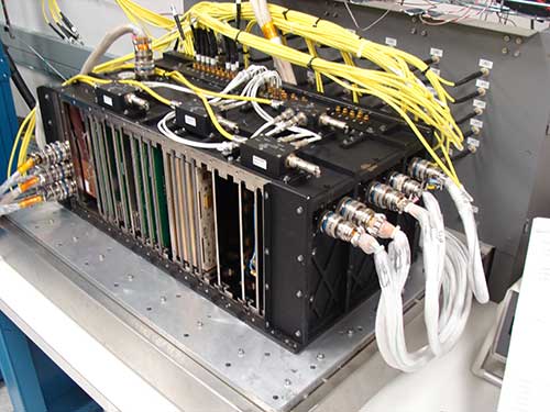
    Harris Corporation is a subcontractor to Lockheed Martin for development and production of GPS III Mission Data Units (MDUs) and transmitters for the GPS space section. Six have been delivered.

    The Harris MDU, together with the Atomic Frequency Standards and the L-band transmitter equipment, make up the Navigation Payload Element. The MDU performs the primary mission of the GPS satellite: generation of the navigation signals and data on a continuous basis. The MDU controls the generation of the precise timing signals used for navigation signals while distributing the timing signals to other satellite components.

    This MDU is 70 percent digital. The next to come, aboard GPS IIIF satellites, will be fully digital.

    When asked about the advantages of an all-digital payload, Harris Corporation’s Jason Hendrix, PNT program director, told GPS World in April 2018, “The advantages and the 30 percent difference are the timekeeping system portion. We’re moving from manual, analog timing to digital to deliver to the Air Force more flexibility. It’s a nice option to have to be able to reprogram in orbit and maybe enhance capabilities desired in the future.”

    LIVING BETTER, LIVING LONGER

    Greater mission longevity is one of the key improvements GPS III delivers over those currently in service. Space Vehicles 1–10 have a planned mission life of 15 years, 25 percent longer than their predecessors. That begs the question, “How long should a satellite live in space, with technology innovation occurring almost annually?”

    Advanced payload technology provides a partial answer. Lockheed Martin and Harris point to new payload capabilities with built-in flexibility to adapt satellites in orbit to technology advances, as well as changes in missions. According to Harris, the fully digital navigation payload will provide the ability to change and upgrade the satellites incrementally over mission life.

    In late 2017, Lockheed announced a partnership with NEC Corporation to introduce artificial intelligence for computer learning in orbit. The company touted significant advances in processors and a move toward next-generation antennas, arrays and transmitters to drive more satellite flexibility, capability and resilience.

    FROM THE GROUND UP

    GPS IIIF’s M-Code can be broadcast from a high-gain directional antenna in a concentrated, high-powered spot beam, in addition to a wide-angle, full-Earth antenna. (Artist rendering: Lockheed Martin)
    GPS IIIF’s M-Code can be broadcast from a high-gain directional antenna in a concentrated, high-powered spot beam, in addition to a wide-angle, full-Earth antenna. (Artist rendering: Lockheed Martin)

    GPS III’s military upgrades require new ground control stations, a replacement effort called OCX that has suffered repeated delays and cost increases, due to the complexity of the programming and requirements modifications. The new jamming-resistant military signal will not be available until the new, highly complex ground control system is available, and that is not expected until 2022 or 2023. Delay and cost considerations were driven in part by full implementation of all Department of Defense 8500.2 “Defense in Depth” information assurance standards without waivers, giving it the highest level of cybersecurity protections of any DoD space system.

    Deliverables for GPS OCX are divided into three blocks. Block 0 delivery took place in fall 2017, enabling it to support the December launch. Block 1 delivery will take place in 2021, providing full operational capability to control both legacy and modernized satellites and signals. Block 2, delivered concurrently with Block 1, adds operational control of L1C and modernized M-code.

    In 2018, wrote Col. Whitney of the GPS Directorate, “We have actively utilized the [Block 0] system in a variety of exercises, training events, compatibility tests and launch readiness events. We also completed a comprehensive security review of the system to demonstrate our readiness to start operations. The system is ready to go. We continue to work the development of the OCX Block 1 system and are wrapping up the initial coding of the system early in 2019, leading into our integration and test campaign.”

    Given delays in OCX, “the Directorate is actively working two major upgrades to bridge the gap,” Whitney continued. “The first is GPS III Contingency Operations (COps) modification which will allow the 2nd Space Operations Squadron (2SOPS) to command and control the GPS III family of vehicles in a mission state matching today’s legacy signals for all users world-wide. The second modification is M-code early use (MCUE), which enables 2 SOPS to operationalize the Modernized GPS military (M-code) navigation signals for the warfighter.”

    Before December’s launch, OCX underwent rigorous cybersecurity vulnerability assessments that tested the system’s ability to defend against both internal and external cyber threats. GPS OCX prevented the broadcast of corrupt navigation and timing data in all tests, bolstering the program’s readiness for GPS III.

    “We’ve built a layered defense and implemented all information assurance requirements for the program into this system,” said Dave Wajsgras, president of Raytheon Intelligence, Information and Services. “The cyber threat will always change, so we’ve built OCX to evolve and to make sure it’s always operating at this level of protection.”

    The new Harris navigation payload offers a smooth transition to use of OCX. The payload for the first 10 GPS III satellites has been verified for OCX compatibility so the same OCX commands will seamlessly port to the Harris fully digital design, minimizing integration risks and associated costs.

    According the the GAO, “Full M-code capability —which includes both the ability to broadcast a signal via satellites and a ground system and user equipment to receive the signal — will take at least a decade once the services are able to deploy military GPS user equipment (MGUE) receivers in sufficient numbers.” The April 2019 issue of GPS World will review M-code implementation across U.S. DoD platforms.

    THE FUTURE’S NOT OVER YET

    In spring 2018, Lockheed Martin submitted a proposal for the GPS III Follow On (GPS IIIF) program, which will add enhanced capabilities to the satellites. New hardware — a high-gain directional antenna — aims signals in a spot beam at a limited area, but blasts the signal at high power for strategic use by the military.

    Inter-Satellite Links. Block IIIF satellites will carry laser retro-reflectors to enable orbit tracking independently of the satellites’ radio signals, which in turn will allow satellite clock errors to be disentangled from ephemeris errors. A standard feature of GLONASS, this is included in the Galileo positioning system, and was flown as an experiment on two older GPS satellites, 35 and 36.

    In September 2018, the Air Force selected Lockheed Martin to build up to 22 additional satellites under the GPS IIIF program.

  • Directions 2019: GPS program looks toward GPS III launch

    Directions 2019: GPS program looks toward GPS III launch

    Col. Steve Whitney stands beside a statue of General Schriever at Los Angeles Air Force Base, home of the GPS Directorate. (Photo: U.S. Air Force/Joseph Juarez, Sr.)
    Col. Steve Whitney stands beside a statue of General Schriever at Los Angeles Air Force Base, home of the GPS Directorate. (Photo: U.S. Air Force/Joseph Juarez, Sr.)

    By Col. Steven Whitney
    Director, Global Positioning Systems Directorate

    Navigating across the world’s roads with GPS is easy. Navigating through the shifting construction zones, detours, and forks of the GPS Enterprise is not always so straightforward.

    For that reason, the GPS Directorate has placed more emphasis on illustrating, both figuratively and literally, the roadmaps leading to the integration of the GPS Enterprise.

    Before linking everything together, let’s start with an update on each major program effort. This way you can zoom out to see the path ahead; hopefully minimizing any “route recalculating” along the way.

    Program Updates

    The journey to build the new GPS III satellites has been full of twists and turns but we are now close to our destination – in this case the GPS orbit of 12,550 miles above the Earth.

    We not only have 10 GPS III Space Vehicles simultaneously in production at Lockheed Martin’s manufacturing facility in Waterton, Colorado, but are also going full swing on preparations to launch our first vehicle in December 2018 on a SpaceX Falcon 9 rocket – more on this later. The GPS III satellites provide signals designed to improve the user’s ability to navigate.

    In addition to the increased power and greater accuracy, GPS III adds a civil new signal, L1C, designed for compatibility with the international Global Navigation Satellite Systems (GNSS) community.

    GPS IIIF. In September 2018, the Air Force awarded the GPS III Follow-on contract to Lockheed Martin. This $7.2B contract for 22 satellites was the result of a competitive process for a production effort. Based on the GPS III technical baseline, the GPS IIIF family of satellites embraces modernization and capability improvements in multiple areas.

    First, a Regional Military Protection capability will provide increased anti-jam capabilities. Furthermore, a new Search-and-Rescue (SAR/GPS) payload will provide improved timeliness of global search-and-rescue operations. Additionally, a Laser Retro-reflector Array (LRA) payload will enable precise ranging measurements and the program will implement a Unified S-Band capability to address consolidation of telemetry, tracking, and commanding frequencies.

    Finally, the program will host a redesigned Nuclear Detonation (NUDET) Detection System (NDS) solution that has a lower overall size and weight. We look forward to the continued partnership with Lockheed Martin and will be looking collaboratively at opportunities to add additional capabilities incrementally over the life of the 22 GPS IIIF satellite production line.

    OCX, the Next Generation Operational Control Segment. Last year Raytheon delivered the initial system, known as OCX Block 0, to support the launch and on-orbit check-out of the GPS III satellites. This past year, we have actively utilized the system in a variety of exercises, training events, compatibility tests, and launch readiness events.

    We also completed a comprehensive security review of the system to demonstrate our readiness to start operations. The system is ready to go. We continue to work the development of the OCX Block 1 system and are wrapping up the initial coding of the system early in 2019, leading into our integration and test campaign.

    The journey over the past few years has been challenging, but we have emerged stronger, armed with better metrics, and a culture of integrated development (often called DevOps) which puts us on a path to success. There will be challenges and risks in the path ahead but rather than mountains to climb, I see these more as standard blocking and tackling of a software intensive program.

    Col. Whitney next to an artist's depiction of a GPS III satellite in orbit. (Photo: U.S. Air Force/Van Ha)
    Col. Whitney next to an artist’s depiction of a GPS III satellite in orbit. (Photo: U.S. Air Force/Van Ha)

    Legacy Ground Sustainment. Running in parallel to these modernization efforts is the all-important work to sustain our existing GPS infrastructure of our current Operational Control System (OCS). These sustainment efforts ensure GPS continues to be the gold standard in positioning, navigation, and timing but also are a crucial “on-ramp” to facilitate a smooth merge onto the modernized GPS capabilities.

    Since 2014, the GPS program office has incrementally implemented several upgrades that not only maintain our satellite constellation delivery of GPS signal-in-space accuracy of 50 cm, but also significantly increases the cybersecurity posture of the legacy OCS.

    These upgrades culminated with a deployment of the latest modification in October 2018, which finished a worldwide modernization of our entire control system hardware and software. This latest upgrade, known as Version 7.5, virtualized the network, implemented two-factor authentication, and improved encryption for mission data.

    Legacy Ground Improvements. Given the delays in OCX, the Directorate is actively working two major upgrades to OCS to bridge the gap. The first is GPS III Contingency Operations (COps) modification which will allow the 2nd Space Operations Squadron (2SOPS) to command and control the GPS III family of vehicles in a mission state matching today’s legacy signals for all users world-wide. The second modification is M-Code Early Use, which enables 2SOPS to operationalize the Modernized GPS military signals (M-Code) navigation signals for the warfighter.

    User Equipment. As I write this article, soldiers, sailors, marines and airmen are testing and integrating mature, next-generation GPS receiver cards providing more accurate and reliable position, navigation, and timing (PNT) solutions. In 2019, the first increment of Military GPS User Equipment (MGUE) is on track to complete card-level testing to inform Service procurement strategies.

    This exciting work is the culmination of nearly two decades of modernization efforts throughout the GPS Enterprise. In the near term, we are utilizing M-Code capable lead platforms ­— USAF B-2 Bomber, USMC Joint Light Tactical Vehicle, USN Arleigh-Burke Class Guided Missile Destroyer, and Army Stryker combat vehicle — to prove out those capabilities.

    The second increment of MGUE focuses on requirements for precision guided munitions, a joint common modular handheld unit, as well as circuit cards and components for low size, weight and power needs. With MGUE, the DoD and services are poised to have enduring PNT solutions the warfighter can leverage for years to come.

    Integration Roadmaps

    The delivery of individual programs is the stepping stone in the capability deliveries to the warfighter and our civilian users. However, it is our ability to unite a diverse collection of programs and stakeholders, across the GPS Enterprise, which defines our success as the GPS Green Monsters. We have done this by linking cross-program enterprise teams so the sum of the whole is greater than its parts.

    Enterprise Road to Launch (ERTL). The goal is pulling together a series of firsts (new satellite, new ground system, and new launch provider), which has not been done before in the modern GPS Era, to deliver the spacecraft safely on-orbit and under control. Our journey to this historic launch has taken time and effort, and we are enthusiastically awaiting the final steps.

    The first GPS III spacecraft is safely at Cape Canaveral and ready to go. The control system has been tested and run through its paces. The integrated launch team has conducted its exercises and reviews. All signs point to launch in December 2018.

    The launch itself is a significant milestone, and marks a beginning of the orbital phase of GPS III. The Road to Launch team is prepared to execute the launch, the check-out and the day-to-day on-orbit housekeeping until the ground updates are complete to transfer the new GPS III satellite into the active constellation later in 2019.

    Enterprise Road to Mission (ERM). The goal is bringing the GPS III satellites into the active constellation providing mission similar to today’s capabilities. A key enabler of the ERM IPT’s success is their development of the first-ever Enterprise “Integration Playbook”, which is the tangible, documented output of a significant dedicated planning effort.

    The Playbook captures how all the pieces and efforts from each stakeholder community tie together to achieve Operational Acceptance of the first GPS III satellite, the USNDS payload, and the COps modification to OCS. The “Playbook” describes in clear and concise terms how these deliveries integrate across the GPS Enterprise, as well as how tasks and milestones from various stakeholders converge to achieve clear end states.

    Enterprise Road to M-Code Mission, or ERM-M-Code. Shifting now to our military users, the purpose of the ERM-M-Code team is to lead the early delivery of a more robust, resilient, jamming/tampering-resistant PNT signal capability to warfighters.

    The rollout of the operational M-code capability depends on the success of the M-Code Early Use modification to OCS, installation of new M-code signal monitoring equipment at sites around the globe, modification of mission planning software, Military GPS User Equipment Increment 1 development, service lead platform integration efforts, and operationalization of space receivers.

    Our ultimate objective is to improve the ability of the Combined Space Operations Center (CSpOC) to respond to urgent PNT needs of the combatant commanders, as they engage more sophisticated adversaries. We remain closely aligned with our peers at USSTRATCOM, AFSPC and user communities.

    Conclusion

    It is an exciting time to be a GPS Green Monster! These roadmaps are by no means easy to create and execute. It is thanks to the remarkable people of your GPS Directorate that these multifaceted challenges are unraveled, aligned, and resolved. The team has worked incredibly hard this past year to position our systems for major, integrated deliveries over the next couple of years.

    It has been the highlight of my career to serve with these men and women and I can’t wait to see where we — and the GPS Enterprise — go next.

  • GAO targets DoD cyber vulnerability

    GAO targets DoD cyber vulnerability

    In a 50-page report to the U.S. Senate Armed Services Committee, the government’s General Accounting Office (GAO) finds that U.S. weapons systems are, almost across the board, highly vulnerable to cyber-attack. Furthermore, the Department of Defense (DoD) has gotten off to “a late start” in prioritizing cybersecurity, and has only “a nascent understanding” of how to develop more protected weapons systems. The October 2018 report, “Weapons Systems Cybersecurity,” is subtitled “DoD Just Beginning to Grapple with Scale of Vulnerabilities.”

    [Image above: Figure 2 from the GAO report: Embedded Software and Information Technology Systems Are Pervasive in Weapon Systems, represented via Fictitious Weapon System for Classification Reasons). Source: GAO analysis of Department of Defense information, GAO-19-128.]

    GPS can figure to be among these threatened systems, and GPS guidance aboard many munitions and almost all platforms vastly expands the danger. The satnav system is not mentioned by name in the report (“To present information in an unclassified format, we do not disclose details regarding weapon system vulnerabilities, which program offices we interviewed, or which cybersecurity assessments we reviewed.”), and the word navigation surfaces only once, but it’s an alarming appearance:

    “Weapon systems are dependent on external systems, such as positioning and navigation systems and command and control systems in order to carry out their missions—and their missions can be compromised by attacks on those other systems. A successful attack on one of the systems the weapon depends on can potentially limit the weapon’s effectiveness, prevent it from achieving its mission, or even cause physical damage and loss of life.”

    The latter scenario could occur if a GPS-guided armament were hacked and rerouted to a civilian target, for example.

    The GAO states that it warned as far back as 2015, and in repeated instances since that date, that federal and contractor systems face an evolving array of cyber-based threats, including criminals, hackers, adversarial nations, and terrorists. “Threats can range from relatively unskilled “script kiddies” who only use existing computer scripts or code to hack into computers, to well-resourced and highly skilled advanced threats who not only have sophisticated hacking skills, but also normally gather detailed knowledge of the systems they attack.”

    Networks, Computers Increase Vulnerabilty

    The increasingly computerized and networked nature of the U.S. military’s weapons contributes to their vulnerability. As weapon systems become more software- and IT-dependent and more networked, they actually become more vulnerable to cyber-invasion. Networks can be used as a pathway from one accessed weapon to attack other systems.

    “Nevertheless,” the report adds, “until recently, DOD did not prioritize cybersecurity in weapon systems acquisitions. . . . DOD is in the early stage of trying to understand how to apply cybersecurity to weapon systems.”

    As the GPS constellation — the satellites themselves as well as the ground control system — become more software-reliant, including the ability to modify signals by remote software command, this has to be a growing concern for the U.S. Air Force. Difficulties with cyber-proofing the next-generation ground control system, OCX, have been suspected as a leading cause of extended delivery delay in that program.

    DoD officials reportedly confided that it will take time — and possibly some missteps — to learn what does and does not work in combatting cyber-attacks on weapon systems.

    Separately, a UK defense expert consultant stated that Russia had “stolen a march on using cyber-capabilities at a tactical level on the battlefield.” As reported last year in GPS World, Black Sea spoofing incidents aroused suspicion that Russia was testing a new counter-combat technique.

    Another spoofing expert said at the time, “It’s long been assumed that Russia, China and other nations (including the U.S.) have the technology to carry out a spoofing attack. What’s surprising is Russia’s willingness to use it openly and somewhat indiscriminately. It does fit nicely into what has been called Russian disinformation technology.”

    Figure 3 from the GAO report: Weapons Include Numerous Interfaces That Can Be Used as Pathways to Access the System (Represented via Fictitious Weapon System for Classification Reasons) Source: GAO analysis of Department of Defense information, GAO-19-128.
    Figure 3 from the GAO report: Weapons Include Numerous Interfaces That Can Be Used as Pathways to Access the System (Represented via Fictitious Weapon System for Classification Reasons) Source: GAO analysis of Department of Defense information, GAO-19-128.

    The amount of software embedded in weapon systems and subsystems has increased exponentially, expanding the respective weapons’ vulnerable surfaces. According to the military’s Director of Operational Test and Evaluation, “any exchange of information is a potential access point for an adversary. Even “air gapped” systems that do not directly connect to the Internet for security reasons could potentially be accessed by other means, such as USB devices and compact discs. Weapon systems have a wide variety of interfaces, some of which are not obvious, that could be used as pathways for adversaries to access the systems, as is shown in Figure 3.”

    If attackers can access one of those systems, they may be able to reach any of the others through connecting networks.

    Figure 4 from the GAO report: Weapon Systems Are Connected to Networks That May Connect to Many Other Systems (Notional Depiction for Classification Reasons)

    Further, the DOT&E found that some networks were not survivable — that is, able to maintain critical capabilities under applicable threat — in a cyber-contested environment.  The Defense Science Board concluded in 2013 that “the adversary is in our networks.”

    The GAO adds that it and other organizations have been sounding off about such threats since the early 1990s — around the time that GPS itself became operational.

    Tests of major military programs conducted between 2012 and 2017 revealed mission-critical cyber vulnerabilities that adversaries could compromise. “Test teams were able to gain unauthorized access and take full or partial control of these weapon systems in a short amount of time using relatively simple tools and techniques. . . . Once they gained initial access, test teams were often able to move throughout a system, escalating their privileges until they had taken full or partial control of a system.”

    Figure 5: Vulnerabilities that the Department of Defense Is Aware of Likely Represent a Small Amount of Actual Vulnerabilities Due to Limitations in Cybersecurity Testing. Source: GAO analysis of Department of Defense information, GAO-19-128.
    Figure 5: Vulnerabilities that the Department of Defense Is Aware of Likely Represent a Small Amount of Actual Vulnerabilities Due to Limitations in Cybersecurity Testing. Source: GAO analysis of Department of Defense information, GAO-19-128.

    Beginning Steps

    The Department of Defense is “still learning” how to address weapon system security and “still determining” what steps it may take. Implementation, once identified, will surely occupy an extended period. Complicating the picture, if DOD is able to make its newer systems more secure, yet connects them to older, vulnerable systems, the newer systems come into jeopardy.

    Pass the Hash

    A report appendix lists several different types of attacks with such pictorial names as: Man-in-the middle, Pass-the-hash, War driving, and Zero day exploit.

    Respectively, these types of attacks connote:

    • An eavesdropping attack in which the attacker intercepts to read or modify data communications to masquerade as one or more of the entities involved.
    • Capturing an encrypted version of a username and password in order to authenticate to a server or service. The attacker does not have to decrypt the username and password (i.e., they do not actually know what they are), yet can still use them to log in to a system.
    • Driving through cities and neighborhoods with a wireless-equipped computer — sometimes with a powerful antenna — searching for wireless networks potentially to exploit.
    • Taking advantage of a security vulnerability previously unknown to the general public. In many cases, the exploit code is written by the same person who discovered the vulnerability. By writing an exploit for the previously unknown vulnerability, the attacker creates a potent threat since the compressed timeframe between public discoveries of both makes it difficult to defend against.

  • Lockheed preps ground system to support GPS III launches

    Lockheed preps ground system to support GPS III launches

    Once the next-generation GPS III satellites begin launching in December, a series of updates to the current ground control system from Lockheed Martin will help the U.S. Air Force gain early command and control of the new satellites for testing and operations.

    In 2016 and 2017, the Air Force placed Lockheed Martin under two contracts, called GPS III Contingency Operations (COps) and M-code Early Use (MCEU), which directed the company to upgrade the existing Architecture Evolution Plan (AEP) Operational Control System (OCS), which operates today’s GPS constellation.

    The fourth Lockheed Martin-built GPS Ill satellite is fully integrated. (Photo: Lockheed Martin)
    The fourth Lockheed Martin-built GPS Ill satellite is fully integrated. (Photo: Lockheed Martin)

    These upgrades to the AEP OCS are intended to serve as gap fillers prior to the entire GPS constellation’s operational transition to the next-generation Operational Control System (OCX) Block 1, now in development.

    In April, the Air Force approved Lockheed Martin’s critical design for MCEU, essentially providing a green light for the company to proceed with software development and systems engineering to deploy the M-code upgrade to the legacy AEP OCS.

    The Air Force gave a similar nod to COps in November 2016. COps is now on schedule for delivery in May 2019 and MCEU is scheduled for delivery in January 2020.

    “The Air Force declared the first GPS III satellite Available for Launch last year, and it’s expected to launch later this year. Nine more GPS III satellites are following close behind in production flow,” explained Johnathon Caldwell, Lockheed Martin’s program manager for Navigation Systems. “GPS III is coming soon, and as these satellites are launched, COps and MCEU will allow the Air Force the opportunity to integrate these satellites into the constellation and to start testing some of GPS III’s advanced capabilities even earlier.”

    MCEU Capabilities

    Part of the Air Force’s overall modernization plan for the GPS, M-code is a new, advanced signal designed to improve anti-jamming and anti-spoofing, as well as to increase secure access to military GPS signals for U.S. and allied armed forces.

    To accelerate M-code’s deployment to support testing and fielding of modernized user equipment in support of the warfighter, MCEU will upgrade the AEP OCS, allowing it to task, upload and monitor M-code within the GPS constellation.

    MCEU will provide command and control of M-Code capability to eight GPS IIR-M and 12 GPS IIF satellites currently on orbit, as well as future GPS III satellites.

    COps Capabilities

    Following launch and check out, each future GPS III satellite will take its place in the GPS constellation. The COps modifications will allow the AEP OCS to support these more powerful GPS III satellites, enabling them to perform their positioning, navigation and timing missions for more than one billion civil, commercial and military users who depend on GPS every day.

    Besides the addition of GPS III, COps will also continue to support all the GPS IIR, IIR-M and IIF satellites in the legacy constellation.

    Lockheed Martin has a long history of supporting ground systems, providing operations, sustainment and logistics support for nearly 60 Department of Defense satellites, including GPS, often allowing them to double their on-orbit operational design life.

    GPS III Satellites

    Lockheed Martin also is under contract to develop and build 10 GPS III satellites, which will deliver three times better accuracy and provide up to eight times improved anti-jamming capabilities compared to current GPS satellites.

    GPS III’s new L1C civil signal also will make it the first GPS satellite to be interoperable with other international global navigation satellite systems.

  • Money doesn’t buy progress for GPS

    Alan Cameron

    While it sounded like good news at first, once the real results were plucked from the slurry, they resemble nothing so much as the same old uncertainties.

    About the future of GPS III, I mean.

    Additional money allocated by Congress to the Department of Defense budget — $80 billion on top of $549 billion for FY18 and $85 billion added to the $562 billion previously set for FY19 — alleviated longstanding worries about sufficient funding for GPS. The satnav system has always been at the mercy of raiding by other military programs, over budget and cash-strapped. At least that pressure will be off, we thought.

    But money on paper does not always lead, expeditiously or at all, to boots on the ground or birds in the sky. The funds come with an enthusiasm for reorganizing everything. To streamline it, effectivize it, make it more…businesslike.

    In the case of the Space and Missile Defense Command, this means eliminating three top-level decision-making positions, and designating someone other than the secretary of the Air Force as responsible for space budget prioritization.

    Congress stopped short of its initial idea, which was to establish a whole new department for military space activities, separate from and equal to the Air Force. But there’s no doubt that the 2018 National Defense Authorization Act strongly rebukes the current way of doing space things in the Pentagon and the Air Force — while proffering more money to do them.

    Like many announced initiatives to drain the swamp elsewhere, this one has just drawn in more murky water. It may take four or five years, according to some with Pentagon insight, to figure out new procedures, lines of command and the actual fulcrums of decision-making. In the meantime, matters will — you guessed it — slow down.

    All this as the GPS III launch schedule and OCX next-generation ground-control readiness slide rightward, and military GPS user equipment can count on at least a decade to even partially update. Mind you, Increment I of the new M-code cards is not yet complete. Once it is, the three major contractors who have developed them will compete to sell their varying versions to the different branches of the military, the different arms of those branches, and the different weapon systems (716, by GAO’s count) operated by those arms.

    The pursuit of increased resilience in space, clearly destined to be a contested domain in the event of large-scale international conflict, may actually inhibit itself in the near term.

    As noted below, the previous wielder of this space has relinquished satnav matters to take up, as he says, “some unfinished business with life.” I owe him a great debt. He gave me my start here.


    Glen Gibbons Retires

    Glen Gibbons announced his retirement from active leadership of Inside GNSS magazine at the end of last year, when he wrote he was “promoting myself to Editor Emeritus.” Gibbons was editor of GPS World from 1989 to 2005, and editor and publisher of Inside GNSS from 2006 through 2017.

    In 2003, he received the U.S. Institute of Navigation’s Norman P. Hays Award for inspiration and support contributing to the advancement of navigation. GPS World joins all those around the industry and the international GNSS community in recognizing and thanking him for his many years of coverage of and service to the field of positioning, navigation and timing.

  • First GPS III satellite receives commands from OCX

    First GPS III satellite receives commands from OCX

    The first advanced GPS III satellite successfully established remote connectivity and communicated with the next-generation Operational Control System (OCX), further validating the U.S. Air Force’s modernized GPS is ready to launch its first satellite.

    On Nov. 2, GPS III Space Vehicle 01 (GPS III SV01), the first of 10 GPS III satellites designed by Lockheed Martin, and OCX, being developed by Raytheon Corporation, successfully completed Factory Mission Readiness Testing (FMRT).

    The FMRT validated the command and control interaction between GPS III and the OCX’s Launch and Checkout System (LCS) through a simulated full launch and early orbit mission event sequence.

    During this end-to-end system demonstration, command signals were sent from the latest OCX LCS software installed at Lockheed Martin’s Launch and Check Out Capability node in Denver to Schriever Air Force Base in Colorado Springs, Colorado.

    From there, the commands were uplinked back to the GPS III SV01 satellite, currently awaiting a call up for launch at Lockheed Martin.

    “During FMRT, GPS III SV01 received and successfully processed OCX commands that are routinely sent during launch, transfer orbit maneuvers, deployments and payload initialization,” said Mark Stewart, Lockheed Martin’s vice president for Navigation Systems. “We thoroughly tested the first GPS III satellite just like we are going to fly it in 2018.”

    GPS III SV01 and OCX first “talked” to each other during a link check on October 3, 2017.

    “This was the first time the launch and checkout system directly interfaced with the GPS III satellite,” said Bill Sullivan, vice president of Raytheon’s GPS OCX program. “We’re making consistent, steady progress, and that’s driving us toward a successful launch next year.”

    The demo further verifies the space-to-ground compatibility between GPS III satellites and OCX. During a 2013 Compatibility & Integration test, Lockheed Martin’s GPS III Nonflight Satellite Testbed (GNST) — a full-sized, functional satellite prototype — also connected with and received commands from an earlier version of Raytheon’s OCX LCS software.

    On Sept. 22, the Air Force declared GPS III SV01 “available for launch,” with launch expected in 2018. The successful FMRT was the final validation that GPS III SV01 is ready to be shipped to the launch pad.

    GPS III will have three times better accuracy and up to eight times improved anti-jamming capabilities. Spacecraft life will extend to 15 years, 25 percent longer than the newest GPS satellites on-orbit today. GPS III’s new L1C civil signal also will make it the first GPS satellite to be interoperable with other international global navigation satellite systems, like Galileo.

    OCX will revolutionize GPS command and control and mission management capabilities. It will control all legacy and new signals, provide protection against evolving cyber threats, and reduce operation and sustainment costs through efficient software architecture, automation and performance-based logistics. OCX represents a quantum leap in capabilities over the current system, providing flexibility and adaptability to meet future GPS mission needs.

    The GPS III and OCX teams are led by the Global Positioning Systems Directorate at the U.S. Air Force Space and Missile Systems Center. Air Force Space Command’s 2nd Space Operations Squadron (2SOPS), based at Schriever Air Force Base, Colorado, manages and operates the GPS constellation for both civil and military users.

  • The promises of M-code and quantum

    November has certainly been a busy month, and I’ve been lucky enough to be involved in a number of standout events where defense PNT was discussed.

    The National Space-Based Positioning, Navigation, and Timing (PNT) Advisory Board met in California; GPS World hosted a webinar on military PNT technology; and the International Navigation Conference took place in the U.K. Check out a brief roundup of what’s been taking place.

    Next-generation GPS takes steps in the right direction

    The December issue of GPS World magazine has an excellent update from Col. Steven Whitney. GPS itself is often referred to as the “gold standard” by which other GNSS and PNT solutions are benchmarked. And GPS is undergoing a fairly monumental modernization program, in order to stay current and provide the right services to the military. There are broadly three aspects to this: the next-generation ground segment, the space segment, and the user equipment.

    It’s fair to say that the ride hasn’t been a particularly smooth one, and the Next Generation Operational Control System (OCX) has been plagued by delays and challenges. Following a Nunn-McCurdy breach in 2016, the future of the OCX development program looked to be hanging on a knife edge, but the program was recertified and continued.

    At the PNT Advisory Board meeting on Nov. 15, Col. Gerry Gleckel (deputy director, GPS Directorate, Space & Missile Systems Center) gave an upbeat presentation on the status of GPS modernization. Describing the current status of OCX as “working through program challenges,” he described how the first integrated launch rehearsal between GPS III and OCX Block 0 had been completed in August.

    The GPS III satellites themselves are in full production flow, with five satellites at various stages of assembly.

    Figure 1. Five GPS III satellites are in production flow. (Credit: Gerry Gleckel, Nov. 15, 2017).

    The next-generation military receivers, known as Military GPS User Equipment (MGUE), are also under development by a range of vendors, of which L-3 Technologies was the first vendor to receive security certification in 2016. A number of equipment form factors are being developed to address land, sea and air platforms, and great progress is being made.

    Figure 2. Military GPS User Equipment (MGUE) will address a range of platforms. (Credit: Gerry Gleckel, Nov. 15, 2017)

    The U.S. Air Force recently completed a number of successful test flights of a prototype M-code receiver on board a B-2 stealth bomber, which marks an important milestone for the GPS modernization effort. Let’s remind ourselves what M-code is, and what it does for us.

    The promise of M-code

    Until now, the military has relied on the encrypted P(Y) code to provide advantage on the battlefield. Compared to the civilian C/A code, the P(Y) offered improved accuracy, ionospheric correction, resistance to spoofing and a marginal level of jamming resistance.

    M-code is quite a different picture. Rather than the traditional BPSK modulation schemes used by legacy signals, M-code utilizes a type of binary offset carrier (BOC) signal. In the case of M-code, the signal is a BOCsin(10,5) modulation, which has a power spectral density given by:

    This power spectral density can be seen in the figures below, along with legacy C/A and P(Y) codes (and also the new L2C signal on L2). The M-code BOC signal has a number of important properties; I won’t describe all of them, but I will pick out a couple.

    Firstly, the signal is able to support navigation warfare activities. Because the energy in the signal is spread in two lobes away from the center, it allows for the C/A code to be selectively jammed without affecting the military receivers. This is often referred to as “blue force jamming” or “blue on blue jamming,” where friendly forces might wish to perform jamming in an environment in which they are themselves operating. Currently, such blue force jamming is not possible with P(Y) code receivers, without also degrading the friendly force’s receiver.

    Another promise of M-code is the ability to use spot-beam transmissions from Block III satellites. This is where a high-gain antenna on the satellites aims the M-code signal at a specific region of the earth, with much greater received satellite power in that region. The received signal from the spot beam is expected to be around 20-dB more powerful than the conventional full-Earth coverage beam. This means that, in a given conflict region, military GPS receivers should be able to benefit from a large increase in jamming resistance.

    Figure 3a. M-code signal compared to traditional L1 GPS signal. (Image: Michael Jones)
    Figure 3b. M-code signal compared to traditional L2 GPS signal. (Image: Michael Jones)

    Shortly after the GPS Advisory Board meeting in California, on the other side of the Atlantic a range of defense PNT technologies was also discussed.

    International PNT experts gather in the UK

    The International Navigation Conference (INC 2017) is now in its third year, and has been steadily growing in prominence. This year’s event, which took place Nov. 27-30, focused on the themes of resilient PNT, autonomy, and sensor and data fusion. As usual, there was a substantial defense presence.

    I had the pleasure of chairing a few sessions, including a panel discussion on resilient PNT. The event began with a cross-government meeting, where representatives from across the UK government met to discuss PNT issues concerning defense and national security.

    What I loved about this conference is the sheer diversity of PNT topics that were discussed. In the military domain, it wasn’t just the traditional subjects of GNSS, inertial, visual and signals-of-opportunity that were discussed. Also considered was cognitive navigation — how does a soldier’s brain work when in an unfamiliar battlefield? And how will quantum technology benefit defense PNT in the medium to long term?

    The promise of quantum

    Quantum technology has for some time been touted as the future of PNT: clocks so accurate that you’ll never need to worry about timing again. Inertial measurement units that have so little drift, you’ll never need anything else for navigation.

    If you’re not familiar with quantum technology, let me explain. Quantum technology exploits science that cannot be explained by classical physics, such as Newtonian mechanics, thermodynamics and Maxwell’s electromagnetism.

    As atoms get colder, they have lower energy levels and move more slowly. Taking this argument all the way down to absolute zero, the atoms would stop moving. By using lasers to cool atoms to very near absolute zero, the atoms are essentially placed under precise control, and hence are sensitive to changes in the local magnetic and gravitational fields. What does this mean for navigation?

    An excellent INC 2017 session on quantum navigation revealed some of the answers. Dr. Tim Freegarde of the University of Southampton gave the keynote “Navigator’s Introduction to Quantum Technologies,” which was followed by sessions on quantum/classical combined navigation, and quantum technology for performing gravity gradient map matching.

    Quantum sensors rely on a phenomenon known as entanglement, where two physically separated systems are linked in such a way that a measurement of one affects the results of the other. Once atoms have been cooled, they can be made to travel in opposite directions around a loop, where the interference pattern generated allows rotation to be sensed.

    But the atoms can also be sensitive to gravitational and magnetic fields, and frequency. So, amongst many other things, quantum technology allows for more accurate atomic clocks, and rotational and gravitational sensors.

    A huge amount of money has been poured into quantum research in recent years and, whilst it’s clear there is still a long way to go, progress is certainly being made. At the UK National Quantum Technology Hub in Sensors and Metrology, the focus is on achieving sensors that are useful, and not necessarily to look for the highest possible precision. This is essential if quantum sensors for PNT are to be adopted by governments and industry.

    Cyber takes center stage

    At the end of the conference, I had the pleasure of chairing a lively panel discussion on resilient PNT, where I put a number of questions to both the panel and the audience.

    Coming back to satellite navigation, my first question was, “What is the greatest threat to GNSS over the next three years?” You may be forgiven for thinking that “jamming” or “spoofing” was the top answer because, no, the top answer was in fact “cyber attack”.

    Figure 4. At the International Navigation Conference, the audience voted “cyber attack” as the greatest threat to GNSS. (Photo: Michael Jones)

    But what exactly do we mean by “cyber attack”? The word “cyber” is a pretty loose word, which is often misused as a catch-all phrase to cover anything that’s not RF related. Let’s quote the NIST definition of cyber attack:

    “An attack, via cyberspace, targeting an enterprise’s use of cyberspace for the purpose of disrupting, disabling, destroying or maliciously controlling a computing environment/infrastructure; or destroying the integrity of the data or stealing controlled information.”

    How does this apply to military PNT? Well, a key theme from the conference was the trend towards more complex PNT systems. No longer do we have a simple GPS receiver, but an ever-increasing mix of different PNT sensors, and a system more comparable to a computer than a traditional GPS receiver.

    What this means is that modern and future military PNT will be susceptible to the full range of cyber attacks currently associated with computing environments. Guy Buesnel from Spirent Communications gave an excellent keynote presentation where he covered this topic. Describing the “attack surface” for GNSS, he noted how many GNSS receivers currently run embedded operating systems such as VxWorks or Linux, and many support standard protocols such as TCP/IP and USB, all of which leaves them vulnerable to cyber attacks.

    But let’s not despair. The good news is that there is an awful lot to learn from the computing domain. After all, when computers first became vulnerable to cyber attacks, we quickly learned to make use of virus checkers, firewalls and other such mechanisms available to us. And now the domain of cyber security gives us an arsenal of defensive measures to combat cyber-space risks.

    I’ll finish by returning to the PNT Advisory Board meeting in California on Nov. 15, where Harold Martin, director of the National Coordination Office for Space-Based PNT, said “GPS is more computer than radio… GPS receivers lack cyber resilience. This is a national issue.”

    Don’t forget it.


    Equation figure: Michael Jones

  • Directions 2018: Resiliency key to new GPS

    Col. Steve Whitney stands beside a statue of General Schriever at Los Angeles Air Force Base, home of the GPS Directorate. (Photo: U.S. Air Force/Joseph Juarez, Sr.)
    Col. Steve Whitney stands beside a statue of General Schriever at Los Angeles Air Force Base, home of the GPS Directorate. (Photo: U.S. Air Force/Joseph Juarez, Sr.)

    By Col. Steven Whitney
    Director, Global Positioning Systems Directorate

    The most discussed theme in the U.S. Air Force space community over the last year has been “resiliency.” But what does that actually mean, and how can the Air Force increase resiliency in space?

    The GPS Directorate took these questions to heart and thought long and hard about resiliency in our Positioning, Navigation, and Timing (PNT) service. I am pleased to report that we have made significant progress in the past year in our quest to bring a new generation of PNT technology to reality.

    More importantly, our investments in space, ground, and user equipment developments are bringing real, tangible benefits towards providing a more resilient PNT service worldwide. We stand on the cusp of delivering modernized civil and military GPS signals which provide critical pieces to the puzzle.

    Farther into the future, the Air Force is already exploring new, emerging technologies and capabilities to even further advance the robustness of the GPS enterprise, with the vision that GPS will always remain the “Gold Standard” for the worldwide PNT community.

    Resiliency Begins with Signals

    Modernized GPS signals will be the first piece of the puzzle for an overall resilient PNT solution. The community has long anticipated the beginning of the multi-GNSS era.

    The GPS Directorate has embraced this future with a new L1C signal, designed cooperatively from the ground up to be interoperable with international satellite navigation systems. The signal design will greatly improve GPS reception in cities and other challenging environments.

    Another important GPS signal was introduced with our GPS IIF satellites. The L5 signal is designed specifically to meet the demanding requirements for safety-of-life transportation and other high-performance applications.

    This signal is broadcast in a radio-frequency band reserved exclusively for aviation safety services to ensure it has optimal spectrum protection. Together, these two new additions greater improve PNT resilience for civil users around the globe.


    “The need to improve cyber security and protection quite honestly cannot wait until delivery of the Next-Generation Operational Control System (OCX). To that end, the Directorate has focused on high payoff updates for the existing operational system.”


    Other measures already improve resiliency by leveraging existing signals. For example, the L2C signal, when combined with L1 C/A in a dual-frequency receiver, will enable ionospheric error correction and improve positioning and timing accuracy.

    For the military, the directorate has been focused on bring Military Code (M-code) into operations. The M-code signal features advanced anti-jam, anti-spoof, and encryption features that will ensure resilient and dependable PNT solutions for the United States and its allies.

    The rollout of an operational M-code capability involves all segments of the GPS enterprise, and while it has been a long time in coming, the GPS Directorate made big strides this year (see “2017 in Review”). I will touch on the progress we are making in each of our development programs.

    Resiliency in Space

    The GPS space segment is the next step towards a more resilient PNT architecture. Our constellation remains robust and healthy, albeit aging, with 31 operational satellites providing worldwide coverage at the time of this article. The GPS III satellites will bring additional robustness with increased power and accuracy over previous generations of satellites.

    We made big strides towards launching the first GPS III satellite in 2018, and just as importantly, production is in full swing on the rest of the ten satellites. I am incredibly proud of the entire government and contractor team that is meticulously acquiring, assembling, and testing these complex machines.

    GPS IIIF. Farther into the future, the directorate is preparing for the GPS III follow-on program. The Air Force will be adding important new resiliency capabilities, with added signal flexibility via a reprogrammable, digital payload and increased anti-jam support to theater with a Regional Military Protection capability. Over the coming years as the follow-on GPS III satellites join the constellation, they will revolutionize GNSS with the full complement of operational L1C, L2C, L5 and M-code signals.

    Resiliency in Control Segment

    As important as the satellites are, the control segment is just as integral to the overall resiliency of the GPS enterprise. The need to improve cyber security and protection quite honestly cannot wait until delivery of the Next-Generation Operational Control System (OCX).

    To that end, the directorate has focused on high payoff updates for the existing operational system.

    For example, we acquired and deployed software-based GPS monitor station receivers, known as Monitor Station Technology Improvement and Capability (MSTIC) receivers, to replace the aging fleet of existing monitor-station receivers.

    The functionality and expandability of the MSTIC receiver design will facilitate adding further capabilities such as M-code signal monitoring, and even civil L1C, L2C, and L5 signal monitoring.

    The GPS Directorate also deployed a new cybersecurity monitoring suite to enhance cyber defenses. This new suite is in operation today at the GPS Master Control Station (MCS).

    Beyond just improving our cyber protection, the Air Force has also stepped out on several OCX off-ramps to support the launch and operation of the GPS III satellites and mitigate risk of further OCX delays.

    The Contingency Operations (COps) program modifies the existing Operational Control System (OCS) to allow the first GPS III satellites to join the operational constellation. The Air Force also initiated a companion program, M-code Early Use (MCEU) to further update OCS to provide limited M-code operations.

    Together, these two programs provide critical interim steps towards fielding a more resilient constellation.


    See also by Col. Steven Whitney,

    Directions 2018: The GPS year in review


    The OCX program provides the ultimate cyber protection and assurance needed for the GPS enterprise. After emerging from program recertification this year, the program has focused heavily on improved software system engineering and embracing software industry best practices, such as adopting DevOps and greater software automation.

    The program has even leveraged Amazon Web Services’ Gov’t Cloud capability to provide more responsive development and test environments. While the program has a long ways to go, the government and prime contractor, Raytheon, are committed to delivery to ensure a robust and secure ground infrastructure.

    User Equipment: Final Piece

    The final piece of the resiliency puzzle for military customers is our user equipment segment. The directorate has made big strides in delivering the first set of modernized receiver cards for the Military GPS User Equipment (MGUE) Increment 1 program.

    These advanced cards will enable platforms across the U.S. Department of Defense to leverage the new M-code signal, providing a tremendous boost in both anti-jam and anti-spoof capability.

    They will also provide the latest in cryptography to ensure secure, robust protection for the United States and its allies.

    Down the road, the Department of Defense is evaluating additional capabilities and platforms for the MGUE Increment 2 program.

    Currently envisioned to address precision guided munitions, space receivers, and a modernized handheld unit, the Increment 2 program will be laying out an acquisition plan in this coming year to further adoption of M-code signals throughout the military.

    A consideration for the future of user equipment will be exploring processing multi-GNSS signals. While no decisions have been made, multi-GNSS could offer opportunities for even additional resiliency.

    Final Thoughts

    This is an exciting time for the GPS enterprise.

    We stand on the cusp of a new generation of capabilities that will usher in a huge increase in PNT resiliency and robustness. I am astounded at the quality of work that is presented at the many GNSS and PNT conferences around the world, and it is both exciting and humbling to see the community continuing to innovate ways to increase accuracy, integrity, availability, continuity, and performance.

    Likewise, I am honored to lead the men and women of the GPS Directorate as we strive to deliver on our commitments and find new, innovative ways to provide robust and resilient PNT to the world.

    This dedicated team is poised and ready to lead us into the future, and we look forward to working with the entire community to continue delivering the GPS “Gold Standard” in space-based PNT.

  • Directions 2018: The GPS year in review

    Directions 2018: The GPS year in review

    Lockheed Martin’s GPS III clean room in Littleton, Colorado.

    By Col. Steven Whitney
    Director, Global Positioning Systems Directorate

    This year saw the GPS enterprise take big strides towards completing major acquisition and development milestones and overcoming significant program challenges.

    As we close out the year, the GPS Directorate stands poised to launch the first GPS III satellite in 2018.

    The GPS III prime contractor, Lockheed Martin, successfully placed GPS III Space Vehicle (SV) 01 into storage in late February. Following a comprehensive engineering review, SV-01 was determined to be Available For Launch in September.

    Road to Launch. The GPS Directorate also kicked off its inaugural Road to Launch campaign this year, and the satellite recently completed a final factory mission readiness test in November. Just as importantly, production is in full swing on the remaining nine satellites with the SV-02 Available For Launch declaration expected early in 2018.

    The GPS Directorate was also hard at work preparing the request for proposal (RPF) for a follow-on production contract that will add up to 22 additional GPS III satellites. As the U.S. Department of Defense (DoD) finalizes requirements for the program, we stand ready to release the RFP by the end of the year.


    For more perspective on the GPS Directorate from Col. Whitney, see Directions 2018: Resiliency key to new GPS.


    OCX. While the Next Generation Operational Control System (OCX) continued to be a focal point for the DoD, the program has made progress in 2017 following a program restructuring. OCX completed the first integrated live-satellite launch rehearsal with GPS III in August.

    A fitting capstone to the year’s achievement was the long awaited delivery in November of the initial version of OCX, known as the Block 0, to support launch and checkout of GPS III satellites. But while these are encouraging signs, there is still a long road to delivery of the full suite of capabilities in 2022.

    The Contingency Operations (COps) program remained on track this year for delivery in 2019 to support interim GPS III operations. The program completed two (out of three) major software builds this year. The U.S. Air Force initiated a companion program, M-Code Early Use (MCEU), to enable limited M-code operations. MCEU is on target to complete its Preliminary Design Review in November 2017.

    MGUE. Early this year, our Military GPS User Equipment (MGUE) program achieved acquisition Milestone B, allowing it to enter the Engineering and Manufacturing Development phase.

    Just as importantly, MGUE successfully completed two major risk-reduction events. First, the U.S. Army successfully demonstrated 81-mm mortar precision-guided munitions integrated with MGUE receiver cards to complete the first ever M-code guide-to-hit tests in March.

    The Air Force then demonstrated a prototype MGUE navigation unit integrated into the B-2 bomber in four successful flight tests. These tests are an important step towards anti-jam, anti-spoof GPS capability, ensuring secure, robust protection for the United States and its allies.

    So, as we close this year, I am encouraged by our recent successes, but with a clear understanding of the many challenges ahead on the road to GPS modernization. We remain fully committed to meeting our program commitments with transparency.

  • System of Systems: GPS III update, Galileo launch

    System of Systems: GPS III update, Galileo launch

    GPS III 11+

    The fully digital Mission Data Unit (MDU) will create precise civil and military timing navigation signals for GPS III satellites 11 and beyond. Pictured here is the advanced MDU on navigation payloads being delivered for GPS III Space Vehicles 1-10. (Photo: Harris)
    The fully digital Mission Data Unit (MDU) will create precise civil and military timing navigation signals for GPS III satellites 11 and beyond. Pictured here is the advanced MDU on navigation payloads being delivered for GPS III Space Vehicles 1-10. (Photo: Harris)

    Harris Corporation has completed development of its fully digital Mission Data Unit (MDU), which is at the heart of its navigation payload for Lockheed Martin’s GPS III satellites 11 and beyond.

    Harris has already provided MDUs and payloads for the first 10 GPS III satellites, one of which has been declared “available for launch” and the second of which is completing its testing. The other eight are in various stages of production assembly.

    Payloads for the satellites 11 and beyond bring further signal transmit capabilities, providing more powerful signals and built-in flexibility to adapt to advances in GPS technology, as well as future changes in mission needs.

    The new MDU that will eventually go aboard satellites 11+ “can be upgraded incrementally over its mission life due to built-in adaptability,” according to a Harris spokesperson.

    GPS OCX

    The U.S. Air Force Space and Missile Systems Center has accepted delivery of the GPS Next Generation Operational Control System (GPS OCX) Launch and Checkout System (LCS) baseline from Raytheon Intelligence and Information Systems. Also known as Block 0, LCS demonstrated conformance through test and analysis with all contractual requirements. OCX Block 0 is the foundation for Raytheon’s future Block 1 and 2 delivery, slated for 2022.

    LCS is a fully modernized cyber-secure ground system complete with the computing hardware, operations center workstations, and mission application software necessary to launch the first GPS III satellite into orbit and perform initial on-orbit testing.

    Mission operators are now using LCS in the GPS III Mission Readiness Campaign. The ground system is performing as expected during the rehearsals and space vehicle checkout.

    Galileo Launch

    A Galileo satellite undergoes its fit-check validation at the Spaceport. Flight VA240. (Photo: ESA/Arianespace)
    A Galileo satellite undergoes its fit-check validation at the Spaceport. Flight VA240. (Photo: ESA/Arianespace)

    As this magazine goes to press, final preparations are underway for Galileo’s quadruple launch on Dec. 12. The Ariane 5 rocket has completed its build-up at the spaceport in French Guiana and is moving toward payload integration and rollout to the launch zone.

    The four 700-kilo (1,543-pound) Full Operational Capability (FOC) Galileo satellites have completed checkout and one-by-one verification of their interfaces with the payload dispenser that will release them once aloft in mid-Earth orbit.

    They will soon take on fuel for their long space life.

    The satellites will bring the Galileo operating constellation to 22, and, according to the European Space Agency, this will provide availability to users anywhere in the world for a high-quality position solution — defined as position dilution of precision (PDOP) less than 5 — 99.8% of the time.

  • U.S. Air Force accepts delivery of GPS OCX baseline

    U.S. Air Force accepts delivery of GPS OCX baseline

    The GPS Operational Control System's launch and checkout system will control launch and early orbit operations and the on-orbit checkout of all GPS III satellites. (Image: Raytheon)Image: Raytheon
    The GPS Operational Control System’s launch and checkout system will control launch and early orbit operations and the on-orbit checkout of all GPS III satellites. (Image: Raytheon)

    The Space and Missile Systems Center announced that the United States Air Force has accepted delivery of the GPS Next Generation Operational Control System (GPS OCX) Launch and Checkout System (LCS) baseline from Raytheon Intelligence and Information Systems.

    Also known as Block 0, LCS demonstrated conformance through test and analysis with all contractual requirements. OCX Block 0 is the foundation for Raytheon’s future Block 1 and 2 delivery, slated for delivery in 2022.

    LCS is a fully modernized cyber-secure ground system complete with the computing hardware, operations center workstations, and mission application software necessary to launch the first GPS III satellite into orbit and perform initial on-orbit testing.

    LCS forms the basis for the full system delivery, referred to as Block 1, which will provide higher accuracy and globally deployed modernized receivers, to ensure anti-jam capability for military users. It will also provide control of both legacy and modernized satellites and signals, including the new international L1C and modernized Military Code.

    Currently, mission operators are utilizing LCS as part of the GPS III Mission Readiness Campaign. The ground system is performing as expected during the rehearsals and space vehicle checkout, giving the Air Force confidence in its readiness to support launch and on-orbit operations.

    OCX has had numerous challenges delaying the delivery of this critical capability, and this delivery marks a significant program milestone providing the Air Force with a cyber-hardened ground system to support the launch and on-orbit checkout of the GPS III satellites.

    “This is a major milestone for the program, and it keeps the U.S. Air Force on track to launch the first modernized GPS satellite into space next year,” said Dave Wajsgras, president of Raytheon Intelligence, Information and Services. “We have strong forward momentum on the program, and we will deliver the full capability in 2021.”

    The first launch of a GPS III satellite is scheduled for 2018.

  • New players trigger new space race, GPS III update

    New players trigger new space race, GPS III update

    Robin Wrinn
    Robin Wrinn

    This month, we bring you a guest column on the 33rd Space Symposium in Colorado Springs, Colorado. Robin Wrinn, a communications professional based in Atlanta, gives her perspective on the premier annual space event, held in early April. Among her findings: new players in space race, new capabilities afforded by 3D printing and virtual reality, and insights into the GPS III program from Lockheed Martin’s VP for navigation systems.

    — Alan Cameron, editor


    Blue Origin spacecraft.
    Blue Origin spacecraft.

    A host of new entrepreneurial and government players entering the space sector created an underlying sense of excitement that a new “space race” has begun. Visitors attending the 33rd annual Space Symposium first encountered the imposing, reusable Blue Origin spacecraft displayed prominently in front of the Broadmoor Hotel Exhibit Hall. It seemed to symbolically punctuate a statement that the space industry landscape is changing — and putting long-experienced government players and government contract monopolies on notice.

    Hosted by the Colorado Springs-based Space Foundation, this year’s Symposium featured more than 180 exhibitors, including 38 new international partners and space, government and defense officials from more than 30 countries. In addition to the United States, other notable space nations attending included China, Germany, South Korea, Japan, high-level members of Russia’s ROSCOSMOS, and for the first time, the European GNSS Agency (GSA).

    Space Recognized as a Security Asset

    A primary theme throughout the speaker lineup was development of missions and programs to shore up national cyber and space security. Japan, for example, had previously banned all military use of space assets, but according to Shuzo Takada, director general of Japan’s National Space Policy Secretariat, the country has established new laws in part due to growing threats from countries such as North Korea.

    Europe also has joined the club of providers of navigation services and has formally acknowledged the need to defend its member countries against cyber threats. In a keynote session, EU Commissioner for Internal Market, Industry, Entrepreneurship and SMEs, Elżbieta Bieńkowska, the first European Commissioner to address the Space Symposium, noted that Galileo, Europe’s GNSS, went live last December. In 2016, six Galileo satellites were launched building on the six the year before. Today, 17 leading chipset companies, representing more than the 95% of global supply, all produce Galileo-compatible products.

    Bieńkowska also outlined a three-point space strategy for Europe that incentivizes innovation, including investment in R& D projects, but also prompts Europe to officially view space as a security asset. “We for the first time recognize that space is a strategic asset and a central element of Europe’s strategic autonomy. Europe must ensure its own security,” she said.

    In his conference remarks, U.S. Congressman Jim Bridenstine welcomed addition of Galileo’s capabilities to the global satellite infrastructure, noting that GPS capabilities make it as important to our way of life as the electrical power grid. (Indeed, GPS actually enables key capabilities of the power grid through its precise timing, although Bridenstine did not mention this aspect.)

    “There are very strategic risks to our satellite systems and we need to make sure the GPS, GLONASS and Galileo signals provide back0up to one another and are supported in bilateral ways. “

    New Private Investment Sparks Change in Costs and Bidding

    The growing presence of private investment in the space economy was very notable at this year’s Symposium. Jeff Bezos’ Blue Origin is among several entrepreneurial companies — Elon Musk’s SpaceX (Space Exploration Technologies) and Richard Branson’s Virgin Galactic, to name two others — that are challenging the traditional drivers. These new players are upsetting the standard government agency inclination to prefer longstanding relationships over price. Now the bid price gaps are too big to ignore.

    Case in point: SpaceX has twice now in two years won bids to launch GPS III satellites, with price as a major factor. According to a March 2017 U.S. Department of Defense press release, SpaceX will provide the Falcon 9 launch vehicle production, mission integration and launch operation for support of the GPS III mission. The contract awards break a nearly 10-year monopoly held by United Launch Alliance, a joint venture of Lockheed Martin Space Systems and Boeing Defense, Space & Security.

    Previously, Claire Leon, launch enterprise director for the Air Force Space and Missile Systems Center had been quoted as saying the service views the entrance of competition as a good step that will help the government over time. “You’ll see a lot of innovation between multiple contractors to invest in the rocket systems for the United States,” she said.

    Lockheed Martin Touts Digital Tapestry Savings

    Collaborative Human Immersive Laboratory (CHIL).
    Collaborative Human Immersive Laboratory (CHIL).

    During the Symposium, Lockheed Martin Space Systems invited attending media to tour its expansive Littleton, Colo. campus where it is assembling and testing both the next-generation GPS III satellite constellation and the Orion spacecraft. Lockheed Martin is the prime contractor on the GPS III program and is under contract the U.S. Air Force to build eight position, navigation and timing satellites. The contract includes options for up to four more vehicles. In September 2016, the Air Force announced it had exercised the option for Lockheed Martin to build the ninth and tenth satellites, which will include additional hosted payloads to increase accuracy.

    Throughout the tour, Lockheed Martin’s hosts emphasized the company’s cost and time efficiency innovations. We first saw the Collaborative Human Immersive Laboratory (CHIL), where Lockheed is using virtual reality (VR) technology to plan the design and manufacture of nearly all its aerospace components. In one of the largest VR laboratories of its kind, engineering teams review 3D models of product designs, tooling and facilities. Instead of paper, virtual prototyping enable Lockheed’s engineers to inspect holographs of the engineered designs, as well as become avatars to examine designs in virtual environments in full scale and in an immersive way. The lab also is used to conduct virtual dry runs of systems once products get to the shop floor.

    Collaborative Human Immersive Laboratory (CHIL).
    Collaborative Human Immersive Laboratory (CHIL).

    According to Darin Bolthouse, manager of the CHIL, Lockheed Martin began virtual prototyping in 2010 with an initial focus on the GPS III and the Orion space capsule programs. Now the company uses the CHIL across the enterprise for all programs. It also is looking for ways to shrink the large lab footprint with newer commercially available VR equipment to create more VR pods at other locations and a site-to-site VR environment network with other facilities, including Sunnyvale, Calif., Kennedy Space Center and Johnson Space Center.

    Again, time and cost savings were emphasized with a primary narrative that “inserting virtual modeling and model-based engineering helps from the ground up.” Touted benefits included recouping an initial investment of $5 million per year since its construction in 2010 through cost avoidance in rooting out specific engineering problems in VR that otherwise would have been discovered on the shop floor. A specific example served up was using the CHIL to virtually redesign the top deck of the Orion spacecraft three times to work out human-machine ergonomic issues.

    Parts made with a 3D printer.
    Parts made with a 3D printer.

    In another leg of the tour, Lockheed Martin showcased how it uses 3D printing to make parts for both Orion and military satellites: tubing routings, bottles and attachments. This has reportedly reduced lead time to manufacture a single part from six months to 1.5 months, with assembly time reduced from 12 hours to just three. Another added benefit is accessibility and costs of replacement parts down the road. 3D printing provides the roadmap and means to recreate a part 20 years later even if Lockheed Martin or a sub-contractor should have ceased operation.

    GPS III Vehicle Rundown

    The highlight of the tour was Lockheed Martin’s top secret clean room, where the next-generation GPS III satellite constellation is being assembled and tested. The expansive space included areas for integrating the parts of each satellite vehicle, as well as environment testing chambers for acoustics and thermal vacuum, which simulate space conditions with extreme temperatures, including the near and far side of Earth solar temperatures. No phones, cameras or recorders were allowed, and even then parts of the satellite vehicles were draped off from visitors’ view.

    3-D printer.
    3D printer.

    Prominent placards gave the GPS III Program Production Status:

    Vehicle 01

    Completed Factory Functional Qualification Testing

    Placed in Storage since February 2017

    Vehicle 02

    Space vehicle integration forecast completion – May 2017

    Environmental testing to begin – May 2017

    Available for launch – 2018

    Vehicle 03

    Navigation Payload forecast delivery – Spring 2017

    Space vehicle integration – Fall 2017

    Begin environmental testing – Early 2018

    Available for launch – 2019

    Vehicle 04

    Navigation Payload forecast delivery – Fall 2017

    Space vehicle integration – Early 018

    Satellite Delays Resolved

    According to Lockheed Martin spokesperson Chip Eschenfelder, who spoke with GPS World during the media tour, previously reported GPS III engineering delays related to the payload have been resolved.

    Lockheed Martin's GPS III clean room in Littleton, Colorado
    Lockheed Martin’s GPS III clean room in Littleton, Colorado

    Lockheed subcontractor Harris Corporation provides the critical mission data unit (MDU) and other components of the navigation payload, including atomic clock timing systems, radiation-hardened computers and powerful transmitters to deliver accurate, robust navigation signals for the GPS III constellation. Last year it was discovered that a ceramic capacitor had not been subjected to all the program’s required qualification tests. Once the issue was discovered, Harris deployed a dedicated team to complete the required tests by December 2016. The issue caused a delay of four months. The part was among the more than 28,000 used in the navigation payloads for the GPS III vehicles. The company announced in February 2016 that it plans to offer a fully digital navigation payload for the GPS III’s space vehicle 11 and beyond.

    According to Harris Corp. spokesperson Ellen Mitchell, the company has so far delivered two full payloads to Lockheed Martin and has delivered some of the hardware for the third space vehicle.

    Another potential GPS III delay presented itself in March 2017 when the U.S. Air Force opened a review of the propulsion systems used for Lockheed Martin’s GPS III and other military satellites, following a problem during an attempt to boost one into orbit. According to Eschenfelder, the review is a standard process and was out of an abundance of caution. Lockheed is“confident that this review will not delay the Air Force’s planned spring 2018 Initial Launch Capability (ILC).”

    Further comments on the GPS III program came in a subsequent conversation I held with Mark Stewart, Lockheed Martin’s vice president for Navigation Systems:

    Q: GPS III has extensive military applications. What differences will it bring to the civil, end-user experience as compared to today’s?

    A: Millions of commercial and civilian users rely on GPS every day. GPS III begins a new era of improved Positioning, Navigation and Timing (PNT) performance for these civilian users in that it will be the first GPS satellite transmitting a new L1C civil signal designed to be compatible and interoperable with other international Global Navigation Satellite Systems (GNSS), like Galileo and QZSS. In the near future, civilian GPS receivers – like those found in smart phones — will be looking for L1C and compatible signals from satellites from multiple GNSS constellations, including GPS III. With more opportunities for GPS receivers to maintain “line-of-sight” L1C connections, civilian users will have much improved connectivity.

    Q: What is the impact of the OCX/ground segment delay? Won’t that impact realizing GPS III’s full capabilities on time?

    A: The first GPS III satellite, GPS III Space Vehicle 1 (GPS III SV01), was placed in storage on Feb. 27 and is now awaiting call up for launch from the Air Force. GPS III SV01 will need the Next Generation OCX Block 0 to launch. We are working closely with the Air Force and Raytheon to demonstrate GPS III SV01 operating on orbit as soon as possible. It is more appropriate for the U.S. Air Force and Raytheon to comment about OCX’s capabilities and what it will bring to the overall GPS III enterprise.

    OCX Block 1 is the baseline program under development to command and control GPS III satellites.  As a temporary gap-filler until OCX Block 1 is available, the Air Force placed Lockheed Martin under contract for “GPS III Contingency Operations” (COps), which will enable the current GPS Operational Control Segment (OCS) to checkout and operate GPS III satellites prior to the delivery of OCX Block 1.  Lockheed Martin’s COps program successful completed a Critical Design Review in November 2016, on schedule for delivery in 2019.

    Q: How do you see the future of GPS in a multi-constellation environment (considering that soon in addition to GPS and the Russian GLONASS, the European Galileo and the Chinese Baidoo will be fully operational)? And what does that mean for the civilian end-user?

    A: Civilian multi-constellation users will significantly benefit from the new L1C signal, designed be compatible and interoperable with the Galileo E1 Open Service (OS) signal. In addition, GPS navigation messages include the GPS/GNSS-time offsets to enable a multi-constellation PNT solution.

    Q: Galileo will be implementing a Commercial Service already in the first generation. Do you think that such a service could be implemented in the future on GPS?

    A: Ultimately the capabilities of future GPS satellites will be determined by the Air Force. That said, Lockheed Martin’s GPS III was specifically designed to be flexible and modular so in the future the satellite could easily incorporate new missions if they are deemed necessary, and new technology as it becomes available.

    Q: What were and are the technology challenges Lockheed Martin faced during the GPS-Ill development?

    A: GPS III is the most powerful GPS satellite ever designed, with three times greater accuracy and up to eight times improved anti-jamming capability. That increased signal power comes from a revolutionary new navigation payload. Early in development our payload provider, Harris Corporation, had some design challenges. Those issues were eventually overcome and fully validated when GPS III SV01 successfully completed its Thermal Vacuum (TVAC) test in December 2015. We are excited to be bringing GPS III’s new capabilities to our warfighters soon.

    Q: How do GPS III satellites compare with Galileo FOC satellite constellation? Achieve parity (Galileo 2 frequency, current GPS 1)? or leapfrogging over Galileo technology?

    A: I cannot speak for Galileo’s capabilities but the U.S. Air Force’s Global Positioning System (GPS) has been the gold standard for PNT for more than 20 years. Lockheed Martin’s GPS experience includes more than 250 collective years of on-orbit operations for the 19 GPS IIR and IIR-M satellites that make up about 60 percent in today’s GPS constellation. With GPS III being the most powerful GPS satellite ever designed and built, I am confident GPS III will maintain that PNT gold standard ranking.

    Q: There were clock anomalies in Galileo. What are you doing to avoid similar issues? Are GPS III clock’s different or the same?

    A: GPS III Rubidium Atomic Frequency Standards (RAFS) have evolved from GPS IIR and IIR-M RAFS, which have collectively and reliably provided more than 250 years of on-orbit service, including significant time beyond their intended design lives. Our GPS III RAFS clocks undergo rigorous environmental qualification and life tests to assure performance over this next generation satellite’s 15-year design life.  In addition, each GPS III SV includes multiple RAFS for redundancy.  GPS III continually monitors the active RAFS to detect and mitigate clock anomalies.  This is just one way that GPS III provides increased signal integrity for GPS users.

    Galileo clocks utilize different suppliers than GPS III clocks. The GPS III clock supplier has produced reliable RAFS clocks for GPS satellites over the past several decades.

    [end of Mark Stewart interview]

    Ground Control

    The GPS III satellite program is heavily dependent on the GPS Next Generation Operational Control System (GPS OCX), which according to  government officials has experienced developmental issues and remains under General Accounting Office (GAO) scrutiny.

    In assessing the implications, it’s important to note that OCX’s development is delivered in blocks, with Block 0 comprising the Launch and Checkout System required to take GPS III satellites into early orbit. Block 1 is built on Block 0  and will deliver the full OCX capability, allowing the Air Force to transition from its current GPS ground controls to the modernized and secure GPS OCX master control station.

    According to the OCX prime contractor, Raytheon, all coding for Block 0 is complete and testing is wrapping up for delivery. Block 1 development is ongoing with the final iteration estimated to be completed in late 2018.

    Findings in a recent GAO report are prompting examination of the reasons for the cost overruns and delays in military development programs. Meanwhile, the Air Force is looking at ways to modify the existing GPS control system to enable the operational use of the GPS III satellites until delivery of the OCX Block 1. Regardless, the Air Force may need to delay the launch of multiple GPS III satellites, according to the GAO.

    Mr. Bezos, Mr. Musk, Mr. Branson … are you out there?