Raytheon reached another milestone in developing the GPS Next-Generation Operational Control System, known as GPS OCX, with the completion of the factory qualification test of the Launch and Checkout System (LCS).
GPS OCX will enable dramatically increased performance and security of the GPS system that benefits millions of people worldwide.
Raytheon tested 74 OCX segment requirements at its Aurora, Colorado, factory in a cyber-hardened environment, verifying that the LCS is well on its way to meeting U.S. Air Force requirements.
Next, the remaining OCX segment requirements will be qualified in a retest period, and those requiring external interfaces will be qualified onsite at Schriever Air Force Base before delivery of the overall OCX LCS in 2017.
The final phase of testing — Site Acceptance Testing — will follow the delivery of the system.
“The completion of the Factory Qualification Test proves we can meet the U.S. Air Force requirements and are on a path to delivering the OCX LCS in 2017,” said Bill Sullivan, vice president and program manager for Raytheon’s GPS OCX. “This critical system will enable the launch of the GPS III satellites, which represents the first major capability deployment in the U.S Air Force’s effort to modernize GPS.”
The Factory Qualification Test achievement builds upon other OCX milestones achieved in 2016, including:
Completion of Black Wide Area Network testing of unclassified external interfaces for GPS OCX with perfect scores on mission capability and cyber controls
100 percent requirements pass rate on Electro-Magnetic Interference testing on the OCX Monitor Station Receiver Element, or OMSRE
Successful Critical Design Review for OMSRE hardware development
Completion of the LCS component-level qualification test
Risk-reduction testing functional checkout for the OCX ground system software, demonstrating OCX’s capabilities for precision navigation and timing in a fully cyber-hardened environment
The U.S. Air Force-led GPS Modernization Program will yield new positioning, navigation and timing capabilities for U.S. military and civilian users across the globe. Developed by Raytheon under contract to the U.S. Air Force Space and Missile Systems Center, GPS OCX is replacing the current GPS operational control system and will support the launch of the GPS III satellites.
The new system will provide enhanced performance, the effective use of modern civil and military signals and secure information-sharing with unprecedented cyber protection.
The U.S. Air Force approved Lockheed Martin’s design to upgrade the current GPS satellite ground control system with new capabilities that will enable it to operate more powerful and accurate GPS III satellites.
The successful Critical Design Review (CDR) for the Contingency Operations (COps) contract, completed on Nov. 17, gives Lockheed Martin a green light to proceed with software development and systems engineering to modify the existing GPS ground control system, called the Architecture Evolution Plan (AEP) Operational Control Segment.
SV 01 in testing at Lockheed Martin’s Denver facility. (Photo: LMCO)
The AEP is currently maintained by Lockheed Martin and controls the 31 GPS IIR, IIR-M and IIF satellites in orbit today.
The COps modifications will allow the AEP to support the more powerful, next generation GPS Block III satellites, enabling them to perform their positioning, navigation and timing mission, once they are launched. COps is envisioned as a temporary gap filler prior to the entire GPS constellation’s transition to operations onto the next generation Operational Control System (OCX) Block 1, currently in development.
“The GPS constellation is a valuable asset to our warfighters, our nation and the world. This risk-reduction effort ensures the Air Force has the ability to maintain the constellation at full strength,” said Mark Stewart, vice president of Lockheed Martin’s Navigation Systems mission area. “We are here to support the Air Force and the GPS III program any way we can.”
The Air Force awarded the $96 million COps services and supplies contract to Lockheed Martin on February 3. The government approved the company’s proposed ground system modification during a Preliminary Design Review on May 11.
On Oct. 15, under a separate contract, Lockheed Martin completed the Commercial Off-the-Shelf (COTS) Upgrade #2 (CUP2) project — part of a multi-year plan to refresh the AEP’s technology and enhance the system’s ability to protect data and infrastructure from internal and external cyber threats, as well as improve its overall sustainability and operability. CUP2 is now fully operational and managing the current GPS constellation.
Lockheed Martin has a long history of supporting ground systems, providing operations, sustainment and logistics support for nearly 60 Department of Defense satellites, including GPS, often allowing them to double their on-orbit operational design life.
Lockheed Martin also is under contract to develop and build the Air Force’s first ten GPS III satellites, which will deliver three times better accuracy, provide up to eight times improved anti-jamming capabilities and extend spacecraft life to 15 years, 25 percent longer than the newest GPS satellites on-orbit today.
GPS III’s new L1C civil signal also will make it the first GPS satellite to be interoperable with other international global navigation satellite systems.
I’m proud to be a part of the accomplishments of the men and women of the Space and Missile Systems Center’s Global Positioning System Directorate at Los Angeles Air Force Base in El Segundo, California. The year has been extremely challenging, but looking back on 2016, we have taken real steps forward to modernize the GPS Enterprise and the way we do business. I’d like to share some of our major accomplishments (see “2016 Accomplishments” below) and challenges, and provide some insights for 2017 and beyond.
Col. Steven Whitney. (Photo: USAF)
Civil Partnerships
While much of our focus is on military capabilities, GPS is a global utility with very strong ties to the civil community. The same principles of transparency and communication are cornerstones of our relationships with the various stakeholders.
One example of this is our work with the Federal Aviation Administration and the Department of Transportation, where the safety-of-life applications are a key element of our discussions. To ensure a transparent, communication-rich relationship, we hold quarterly program management reviews with these organizations and their stakeholders.
The GPS Directorate continues to actively participate on a number of committees, such as the Civil GPS Service Interface Committee, that are key to maintaining ties to our civil stakeholders and ensuring that we have an effective flow of information both to and from the Directorate.
We are currently engaged in the DOT-led Adjacent Band Compatibility study, initiated by the National Space-Based PNT Executive Committee. This year will see the culmination of the effort to determine power levels from potential future adjacent-band sources that are compatible with existing and evolving GPS receivers, and serve as a foundation to determine power levels compatible with evolving GPS/GNSS receivers.
This study exemplifies our strong ties with the greater GPS community, as well as my push for the Directorate’s efforts to be as transparent as possible, execute data-driven decisions, and be guided by widely accepted international standards.
Space Segment
A key milestone occurred Feb. 5, 2016, with the launch of our 12th and final GPS IIF satellite. This marked the end of an extremely successful GPS IIF launch campaign and our most aggressive launch schedule in the last 20+ years: eight successful launches in 24 months!
The addition of the GPS IIF satellites to the constellation enabled the system to reach its best performance day ever on May 11, 2016, achieving 36.5-centimeter accuracy in average user range error.
Col. Whitney with the Green Monster, mascot of the U.S. Air Force GPS Directorate. (Photo: USAF)
Moving over to our next generation GPS III satellites, SV-01 continues to make steady progress. In August, the team executed successful functional and physical configuration audits with Lockheed Martin, completing a key task on the road to achieving our available for launch (AFL) date. The AFL declaration signifies completion of production activities, and allows initiation of the Mission Readiness Campaign for launch upon Air Force direction.
As we march towards AFL, we are tackling several technical challenges, including a capacitor issue discovered during our investigation of SV-03 flight hardware tests. This capacitor is used in many places throughout the navigation payload. Our investigation uncovered inadequate qualification processes by a major subcontractor. Exercising due diligence, the Air Force is now verifying both the build quality of the entire capacitor manufacturing process and production lot via additional capacitor qualification life testing. This activity delayed our AFL until December 2016, approximately a four-month delay from our previous forecast.
The program is also working to solve several other technical challenges as we progress to completion. SV-01 testing uncovered electro-magnetic interference between a payload component and a hosted payload. Testing also uncovered electron impact issues on the L-band antenna elements. In partnership with Lockheed Martin, the program developed corrective action and design mitigations for both of these issues and is implementing these steps within our production flow for all the SVs. Of course, all these issues together have led to increased cost and contributed to delays in final delivery.
In the coming year, SV-02, the second GPS III satellite, will also be progressing towards completing production. Currently, all of the SV-02 sub-assemblies have been received by Lockheed Martin and are being integrated into the spacecraft. The next major step in the production flow for SV-02 will be to mate it with its propulsion core.
Recently, we completed negotiations with Lockheed Martin to extend the production line with purchases of SV-09 and SV-10. These satellites will be technically equivalent to SV-01 through SV-08. This $395 million purchase of two satellites marks a significant affordability milestone for the procurement of GPS III satellites.
Looking ahead, we are analyzing how to acquire satellites beyond SV-10. We are executing a phased strategy which starts first with determining the viability of a GPS III production design existing beyond the current contractor. We awarded an initial phase of contracts to the Boeing Company, Lockheed Martin Space Systems Company, and Northrop Grumman Aerospace Systems in May 2016 to provide a feasibility assessment of the readiness of their satellites designs. In this phase, the contractors will provide a GPS III production design, manufacturing plans and a navigation payload brassboard test report, along with manufacturing/production processes and facilities maturity.
We are also collaborating closely on an Air Force Research Laboratory Space Vehicles Directorate activity, the On-orbit Reprogrammable Digital Waveform Generator program, as an opportunity for the three contractors to develop advanced GPS L-band navigation signal processing capabilities in a smaller, more efficient package. This effort could potentially provide future satellites enhanced security in contested environments, more capable signal generation, and additional GPS waveforms to meet the growing needs of both military and civilian users.
Looking further ahead, the second phase is envisioned to be a full and open competition with contract awards starting in 2018. Contractors will be required to deliver the first satellite in time to support constellation sustainment commitments.
Control Segment
Our Control Segment consists of both OCX and our existing Operational Control Segment at Schriever Air Force Base, Colorado. The OCX program has struggled with many challenges through the years, producing a cost and schedule growth on OCX that exceeded the prescribed thresholds — in our case, a 25 percent cost growth against the approved Program Baseline.
I notified the Secretary of the Air Force on June 14 of this development, and on June 30 the Air Force declared a critical Nunn-McCurdy breach on the OCX program. The Nunn-McCurdy process is a mechanism for Congress to maintain oversight of DoD programs and requires the Office of the Secretary of Defense to conduct a review leading to a decision to either certify as critical to National Security or terminate the program.
The GPS Directorate and Raytheon, the OCX prime contractor, worked closely with teams conducting this in-depth, comprehensive review. The result was determined on Oct. 12 that OCX is essential to national security that no alternatives exist to meet requirements at less cost, remaining costs for the restructured program are reasonable and a higher priority than programs whose funding must be reduced to accommodate the growth, and management structure for the program is adequate.
With the review behind us, our challenge is to move forward with a stronger, healthier, more focused OCX program. To accomplish this, we are focused on several major areas: stronger systems engineering practices, establishing a single common hardware/environments baseline, greater software installation automation, and implementing industry standard software development processes.
One of our first milestones next year will be the delivery and deployment of OCX Block 0 in the summer of 2017. Block 0 is the GPS III Launch and Checkout System and provides a subset of the full OCX capabilities needed to launch the GPS III satellites and perform early on-orbit spacecraft bus checkout.
This delivery starts the drive for our inaugural launch of GPS III SV-01 in the spring of 2018. Raytheon completed two Block 0 key milestones since March 2016, and is now in formal qualification testing before it is deployed to operations early next year. The next year will see OCX development focused on Block 1. It provides the Initial Operating Capability to command and control all GPS satellites and enable the PNT mission, including the international L1C signal and advanced M-code features and capabilities.
Because OCX Block 0 is not designed to control the GPS III navigation payload, we are modifying the existing OCS to control GPS III satellites under Contingency Operations, or COps. COps will allow operation of the GPS III satellites launched prior to OCX Block 1 delivery in 2021, and provides the Air Force the ability to fly GPS III satellites at a capability level commensurate to a GPS IIF.
Our COps program has made good progress, completing its Preliminary Design Review last May and successfully passed Milestone B in September. COps is on track to hold its Critical Design Review in November, with delivery planned for the spring of 2019. We are exploring other potential OCS modifications to hedge against further delays in OCX.
Our OCS sustainment team in Colorado Springs recently completed the largest system update in program history. This update is part of our focus to refresh and bolster the cyber posture of the GPS architecture, and modernize the GPS control segment mission servers and hosted commercial software. These upgrades will protect against infiltration of cyber threats and enable improved data traffic logging for network situational awareness to protect this global utility.
User Equipment Segment
Like our other segments, our User Equipment segment had a very challenging but successful year. The MGUE program has worked steadily with our entire industry team, L-3 Communications, Raytheon, and Rockwell-Collins, to complete and test MGUE Increment 1 production prototypes. These Final Test Articles, or FTAs, started delivering this summer and are now capable of acquiring and actively tracking live-sky M-code. With the initial risk reduction testing phase complete, the Directorate will now use the FTAs to perform MGUE developmental testing and verification and hardware qualification testing.
The L-3 design was also the first on our program team to achieve security certification this October, which marks the very first security-certified M-code receiver card. This not only validates the L-3 design and production, it also validates the GPS security certification process, an enduring function for the Directorate in working with industry. This certification also leads the way for the product to be available to a wide variety of users across the DoD.
While progress in MGUE has been significant, creating the next-generation of secure, anti-jam, anti-spoof receivers has been more time-consuming and costly than expected. The drive to support warfighter needs for greater performance drives a diverse set of requirements across the DoD. The Air Force made a concerted effort to improve the resiliency of the MGUE receivers, adding complexity to the program. Combined, these challenges have led to extended delivery schedules for the program.
In the coming years, the MGUE team will lead efforts to integrate MGUE cards into four lead DoD platforms: the Air Force’s B-2 bomber, the Navy’s Arleigh Burke-class destroyer, the Army’s Distributed Defense Advanced GPS Receiver Device for the Stryker armored fighting vehicle, and the Marine Corps’ Joint Light Tactical Vehicle.
The four lead platforms provide pathfinder integrations and operational testing for the entire DoD community as we move into the modernized GPS era. The program office has already been working closely with the B-2 Program Office and the Joint Service System Management Office in fielding an M-code capable flight prototype Miniaturized Airborne GPS Receiver.
We have worked jointly on this first lead platform integration effort to field the first ever MGUE receiver integration into a higher order prototype unit. These efforts yielded tremendous integration insights. Prototype lab testing demonstrated live-sky tracking of C/A, Y and M-codes; testing of MGUE connected with a new B-2 flight antenna; and culminating in the first end-to-end demonstration of M-code capability.
In 2017, the GPS Directorate will set the acquisition strategy and plan forward for the MGUE Increment 2 program, addressing our long-term strategy for Application Specific Integrated Circuits, as well as meeting the needs of future platforms such as precision guided munitions, space receivers, and a modernized GPS handheld.
The Space Enterprise Vision
Earlier this year, General John Hyten, former commander of Air Force Space Command, announced the Space Enterprise Vision. The SEV is the result of an AFSPC study that looked at ensuring national security space capabilities in a contested environment, with an emphasis on improved resiliency. In the PNT mission area, there are many ways to provide greater resiliency in-line with General Hyten’s SEV. One that we are leaning forward and looking very hard at is multi-GNSS possibilities.
At the recent Institute of Navigation conference, many presenters noted that for the consumer market, the multi-GNSS era has already begun. Potential incorporation of non-GPS signals into military user equipment is still under review, but certainly offers the possibility of improving resilience to jamming, spoofing, and operations in obstructed terrain. The broader GPS community is developing approaches to assess multi-GNSS integrity, and we are working with those community members to evaluate the potential impacts to our GPS architecture, especially the ground.
Another resiliency initiative we are participating in is a DOT-led effort known as Advanced Receiver Autonomous Integrity Monitoring backed by PNT experts from the labs and academia. Once the technical aspects are well understood and the policy decisions are made, the GPS Directorate will be well positioned to take advantage of this opportunity.
Conclusion
2016 has been a very challenging and successful year. Looking forward into 2017 and beyond, we have numerous challenges across all segments of the Enterprise — OCX, GPS III, and MGUE — to deliver a modernized architecture. The men and women of the GPS Directorate and our Industry partners are truly some of the hardest working people I have ever had the opportunity to work with. It is their passion and dedication that has allowed us to continue to deliver the Gold Standard. It is my honor to serve with, and for, them.
2016 Accomplishments
Our GPS Next-Generation Operational Control System, or OCX program, received the majority of the press attention this year. OCX has struggled to overcome information assurance challenges, as well as poor systems engineering processes and planning from the outset of the program. The cost and schedule growth triggered a rigorous review by the Office of the Secretary of Defense.
The outcome, we believe, will be a restructured, more executable program that is implementing stronger systems engineering practices and industry-standard software development processes. We still have a ways to go to be successful, but realize we must deliver the capability to command our GPS satellites and will continue to explore programmatic off-ramps should the OCX program falter.
The past year also saw us bring to a close the GPS IIF production and deployment activities with the successful launch of our 12th and final GPS IIF satellite. Our GPS constellation remains healthy, stable and robust with 31 operational space vehicles: 12 GPS IIR, seven GPS IIR-M, and 12 GPS IIF.
We ushered in the GPS III era with the completion of Space Vehicle-01 thermal vacuum testing late in 2015 in an unprecedented 72 days. We have, however, uncovered several technical issues challenging our availability for launch. As we ready SV-01, a tremendous effort is ongoing to fully investigate and exonerate these issues to ensure our satellites deliver the capabilities you’ve come to expect from the Gold Standard.
This year our partners in the Launch Enterprise Directorate awarded a GPS III launch services contract to the Space Exploration Technology Corporation, or SpaceX — their first National Security Space System launch.
Finally, our Military GPS User Equipment (MGUE) program delivered its first set of Military Code compliant production prototypes for developmental testing and integration. Just as significant, the MGUE program granted the first-ever full security certification to contractor L-3 Communications. These major GPS modernization milestones are successful initial steps, but the progress in delivering the most secure, anti-jam, anti-spoof GPS receivers ever has taken longer than expected, and a great deal of work lies ahead.
This is by no means an exhaustive list of the year’s accomplishments and challenges, but it demonstrates that we are continuing to modernize the GPS system and maintain transparency on our commitments.
Harris Corporation delivered the first of 34 modernized receivers to support the GPS Next-Generation Operational Control System (OCX). They will receive the signals sent by the current GPS satellite constellation plus the new signals sent by the next generation GPS III — 13 military and civilian signals in all.
The receiver was shipped to the prime contractor, Raytheon Company, in Aurora, Colorado, after it passed a critical electromagnetic interference test, the first of many stringent qualification requirements. Though the receivers will be placed throughout the world, this first production unit will be installed in Aurora as OCX software development and integration continues.
OCX will replace the existing ground control system that receives signals from the 31 operational GPS satellites already orbiting Earth. Only OCX will be able to receive and decrypt all GPS III military and civil signals, however.
In addition to receivers, Harris has delivered 14 ground encryptors that will help protect the GPS signal. Harris also is providing critical software elements, which provide the fundamental navigation data to the GPS satellites and enable U.S. Air Force operators to better know and monitor the exact position and timing of the GPS constellation.
Risk Reduction Testing Completed for GPS OCX
Image: Raytheon
Raytheon reached a milestone in development of the GPS Next Generation Operational Control System (OCX), completing a series of Risk Reduction functional checkouts of OCX Block 1 capabilities, with a focus on OCX software.
This activity integrated iteration 1.5 of the OCX Block 1 Master Control Station with the GPS System Simulator and ran operational scenarios, representing the first end-to-end integration of available Block 1 capabilities.
The testing included GPS constellation management and sustainment, demonstrating OCX’s abilities for precision navigation and timing capabilities in a fully cyber-hardened environment.
The test also included running Kalman filters and generating GPS satellite navigation uploads. Future development will add to and expand capability to include both the civil and military modernized signals.
OCX’s development is delivered in “blocks,” with Block 0 comprising the Launch and Checkout System to take GPS III satellites into early orbit. Block 1 is built on Block 0 and delivers the full OCX capability, which allows the Air Force to transition from its current GPS ground controls to the modernized and secure GPS OCX master control station.
GPS OCX is being developed by Raytheon under contract to the U.S. Air Force Space and Missile Systems Center.
M-Code User Equipment Certified
L-3 Communications announced that its next-generation military code (M-code) GPS user equipment has successfully completed the final step in a government security certification process. L-3’s M-code GPS features advanced user equipment technology, increasing soldiers’ ability to resist enemy jamming and spoofing and performing significantly better in contested environments. The development and certification of this technology was performed under the Air Force Military GPS User Equipment (MGUE) program led by the GPS Directorate.
Certification review was performed by an independent government review team, with a focus on the security design of the L-3 GPS User Equipment. The goal of these new security standards is to further protect the integrity of the navigation and timing solutions and provide required safeguards for critical information inside GPS User Equipment.
Work on this project will be done by L-3 Interstate Electronics Corporation (L-3 IEC), which is part of the Precision Engagement and Training sector within L-3’s Electronic Systems business segment.
The first eight GPS III satellites are under contract and in production at Lockheed Martin’s GPS III Processing Facility outside of Denver.
GPS III Satellites 9 and 10 Procured, Launches Targeted for 2022
The U.S. Air Force Space and Missile Systems Center awarded a contract option to Lockheed Martin Space Systems Company to procure two additional GPS III satellites, space vehicles nine and 10 of the next generation. The contract option procures long lead and production hardware.
“The GPS III SV 9 and 10 satellites are expected to be ready for launch in 2022, thus sustaining the GPS constellation and the global utility the world has come to expect,” said Lt. Gen. Samuel Greaves, the Space and Missile Systems Center’s commander.
The Lockheed Martin team is finishing up final testing and integration activities on the first GPS III satellite, GPS III SV01, and is preparing to deliver it to the Air Force later this year. The second satellite, GPS III SV02, is poised to have its major functional systems fully integrated into one space vehicle prior to starting its own environmental testing. GPS III SV03 also is beginning to take form in the company’s production clean room as its major subcomponents are being assembled. All eight of the first set of GPS III satellites are in various stages of production at Lockheed Martin’s GPS III Processing Facility outside of Denver.
The government expects to compete future purchases of GPS III satellites, beginning with GPS III SV 11. This competition will maintain the current technical baseline of GPS III and will add additional hosted payloads to increase system accuracy, search-and-rescue capability, and universal S-band compatibility.
European GNSS Service Centre Opens
The European GNSS Agency (GSA) is gearing up to assume its operational role for Galileo in early 2017. This summer, the GSA formally accepted the Loyola de Palacio facility in Madrid, Spain, that houses the European GNSS Service Centre (GSC). This is a significant milestone in the development of the programme and its service provision as Galileo’s “door to the GNSS world.”
GSA already oversees the operation and service provision for the European Geostationary Navigation Overlay Service (EGNOS), along with managing the security accreditation and general security provision for both programmes.
The GSC offers 1,100 square metres of space and employs over 40 people. Since 2013, the core team at GSC has been providing limited services and working as a precursor to GSC v1. Its key work includes supporting the lead up to Galileo Initial Services provision, along with operating the GSC Helpdesk, disseminating orbital products to the search-and-rescue community, supporting GNSS-related research and industrial activity, and monitoring user satisfaction.
Once operational, GSC v1 will be connected to the Galileo core system, enabling the long-anticipated Commercial Service. This service is expected to enter operations by mid-2017.
By Karen Parrish, DoD News, Defense Media Activity
An Air Force program that will provide a vital new command system for the global positioning system satellite constellation in the shortest time possible will continue despite cost growth, Defense Department officials have confirmed.
Frank Kendall, undersecretary of defense for acquisition, technology and logistics, announced Oct. 12 the continuation of an over-cost program supporting the global positioning system. Here, Kendall is briefed by Jose Romero-Mariona on cybersecurity science and technology during Kendall’s visit to Space and Naval Warfare Systems Center Pacific in San Diego, Aug. 24. (Navy photo by Aaron Lebsack)
The next-generation operational control system, known as OCX, reached what is called a Nunn-McCurdy breach on June 30. The Nunn-McCurdy provision applies to weapons programs and requires the military services to notify Congress if a program’s cost per unit increases 25 percent or more over the current baseline estimate.
But well before June 30, defense acquisition experts began working with Raytheon, the contractor for OCX, to resolve program issues. In December 2015, Undersecretary of Defense for Acquisition, Technology and Logistics Frank Kendall directed in-depth quarterly reviews, including a series of “deep dives” overseen by him. Certification activities began in July 2016, and culminated with Kendall certifying the program to Congress yesterday, thus allowing the program to continue.
Next-Generation GPS
James MacStravic, acting assistant secretary of defense for acquisition, discussed OCX and its importance with DoD News.
“This is what the controllers on the ground are going to use to make sure that all the satellites are talking to each other, that they’re exchanging the same information [and] that they’re where they’re supposed to be,” he said.
The OCX system will command all modernized and legacy GPS satellites, manage all civil and military navigation signals and provide improved cybersecurity and resilience for the next generation of GPS operations.
The OCX program includes the following phases: Block 0, to perform launch and checkout of GPS-III satellites; Block 1, to command all navigation signals, including the modernized military signal; and Block 2, for additional enhancements to signal assurance and navigation warfare capabilities. The ground segment capability not only supports military forces, but also civil, commercial and scientific uses. The current total program cost estimate for OCX is $5.46 billion.
OCX will consist of:
A master control station and alternate master control station;
Dedicated monitor stations;
Ground antennas;
GPS system simulator; and
Standardized space trainer
Turning the Program Around
Defense officials said factors in the OCX cost growth included late recognition of the magnitude of information assurance work that was required, concurrent systems engineering that drove significant rework, inconsistent configuration management of the program baselines, immature software and a lack of automation across the program. These issues drove schedule slips, which in turn increased the cost of the program, leading to the breach.
MacStravic described the efforts defense officials and Raytheon have made to turn the program around. He emphasized the work has included the personal involvement of Kendall, Air Force Secretary Deborah Lee James and Raytheon’s chief executive officer.
“What we spent the summer doing was making sure … does this program have the right management resources, the right financial resources and an appropriate schedule to succeed?” MacStravic said.
Officials report that after three on-site quarterly reviews, Kendall’s assessment is that Raytheon is making substantial progress on the program, but that some additional schedule increase has occurred and that there is risk of more schedule increases.
Progress has been sufficient to support certification under the Nunn-McCurdy process, officials said. Kendall’s office will continue the OCX quarterly reviews begun in March 2016, which to date have included the secretary and principal deputy acquisition chief of the Air Force, the program executive officer and Raytheon’s chief executive officer.
The alternatives to certifying the program included several options, including program termination, but this was deemed simply unworkable, due to the extended time it would require to design and field a new ground system for the vital GPS III network.
According to officials, the future of the OCX program will depend upon Raytheon’s ability to demonstrate that it can deliver the needed capability to the Air Force at acceptable cost and within an acceptable time.
Raytheon has reached another milestone in its development of the U.S. Air Force’s Global Positioning System Next Generation Operational Control System, known as GPS OCX. This new system offers significant improvements to the GPS on which the U.S. military and millions of civilians rely, including enhanced availability, accuracy and security.
OCX’s development is delivered in “blocks,” with Block 0 comprising the Launch and Checkout System to take GPS III satellites into early orbit. Block 1 is built on Block 0 and delivers the full OCX capability, which allows the Air Force to transition from its current GPS ground controls to the modernized and secure GPS OCX master control station.
Raytheon recently completed a series of Risk Reduction functional checkouts of OCX Block 1 capabilities, with a focus on OCX software. This latest development activity integrated iteration 1.5 of the OCX Block 1 Master Control Station with the GPS System Simulator and ran operational scenarios, representing the first end-to-end integration of available Block 1 capabilities. The testing included GPS constellation management and sustainment, demonstrating OCX’s abilities for precision navigation and timing capabilities in a fully cyber-hardened environment.
The test included running Kalman filters and generating GPS satellite navigation uploads. The completion of the Risk Reduction functional checkout informs and benefits future OCX development efforts. Future development will add to the existing capability and expand capability to include both the civil and military modernized signals.
The U.S. Air Force-led GPS Modernization Program will yield new positioning, navigation and timing capabilities for both the U.S. military and civilian users across the globe. GPS OCX is being developed by Raytheon under contract to the U.S. Air Force Space and Missile Systems Center, which is replacing the current GPS operational control system.
GPS OCX provides a number of significant modernized capabilities for GPS users, including robust cybersecurity and deployment of jam-resistant, operational military code, or M-code. The OCX Launch and Checkout System provides an early delivery of much of the overall block 1 OCX capability, and will support the GPS III satellite launches.
Harris Corporation delivered the first of 34 modernized receivers to support the GPS Next-Generation Operational Control System (OCX). They will receive the signals sent by the current GPS satellite constellation plus the new signals sent by the next generation GPS III — 13 military and civilian signals in all.
The receiver was shipped to the prime contractor, Raytheon Company, in Aurora, Colorado, after it passed a critical electromagnetic interference test, the first of many stringent qualification requirements. Though the receivers will be placed throughout the world, this first production unit will be installed in Aurora as OCX software development and integration continues.
OCX will replace the existing ground control system that receives signals from the 31 operational GPS satellites already orbiting Earth. Only OCX will be able to receive and decrypt all GPS III military and civil signals, however.
In addition to receivers, Harris has delivered 14 ground encryptors that will help protect the GPS signal. Harris also is providing critical software elements, which provide the fundamental navigation data to the GPS satellites and enable U.S. Air Force operators to better know and monitor the exact position and timing of the GPS constellation.
Pictured here is the advanced MDU on navigation payloads being delivered for GPS III Space Vehicles 1-10. (Photo: Harris)
Europe’s fifth and sixth Galileo satellites, salvaged from their faulty 2014 Soyuz launch, will begin broadcasting working navigation signals for test purposes, for the benefit of receiver manufacturers, service providers and scientific researchers. The European Commission will decide later whether the two satellites will become part of the operational Galileo constellation.
The European Space Agency performed a complex series of in-orbit maneuvers to raise and circularize the two after they arrived in space too low and too elliptical for full Galileo use. Their initial orbits dipped the satellites too close to Earth to keep their antennas properly locked on the planet.
“Once their orbits were modified, their navigation payloads could be turned on and in-orbit testing could take place,” explained Marco Falcone, head of the Galileo System Office. “The good news was their performance was excellent.
“The navigation signals will include a signal health status reading that ‘signal component currently in test’ and its navigation data validity status will be ‘working without guarantee.’ In this way, these signals will not disturb the performance of any receivers using the Galileo signals coming from the other satellites. On the user community side, some application providers are interested in harnessing as many available satellites as possible for precision applications.”
Testing will take place in two phases: initially their navigation signal will be updated via the Galileo ground segment every 14 hours or so. Later this year, the ground segment will be reconfigured to send updates more often, enhancing navigation precision, although they will remain outside the official constellation until decided otherwise.
The two satellites are also midway through an ambitious space experiment to test Einstein’s General Theory of Relativity more precisely than ever before, by measuring how their onboard time varies in accordance with their altitude and therefore gravity, known as their gravitational redshift.
New Activation. Galileo GSAT-0210 (PRN E01), one of two launched May 24, began dual-frequency broadcast on Aug. 17, transmitting E1 and E5a signals.
GPS III launch RFP
Competitive bids invited
The U.S. Air Force released a Request for Proposal (RFP) in August for GPS III-3 launch services, scheduled to begin in 2019. The contract will be a standalone for a single GPS III launch.The United Launch Alliance (ULA) and Space Exploration Technologies (SpaceX) are expected to compete for the contract. In April, SpaceX was chosen to launch the GPS III-2 satellite in May 2018. ULA chose not to compete.
The RFP seeks an Evolved Expendable Launch Vehicle (EELV) Launch Service. The Air Force’s acquisition strategy seeks a balance between mission success/operational needs and lowering launch costs, reintroducing competition for national security space missions.
This is the second competitive launch service solicitation under the current procurement strategy. Previously, ULA was the only certified launch provider. In 2013, ULA was awarded a sole-source contract for launch services as part of an Air Force Block Buy of 36 rocket cores. In May 2015, SpaceX was certified for EELV launches, yielding two qualified launch service providers.
M-code, OCX updates
The Air Force awarded a $52.6 million contract to Raytheon for modernization of the Miniature Airborne GPS receiver 2000 (MAGR-2K): test and delivery of an M-code automatic dependent surveillance and broadcast-capable system. Congress has mandated the military buy only M-code GPS equipment by 2018. Last year, Rockwell Collins received a $36.6 million contract for such equipment.
OCX. Raytheon is implementing changes to its GPS Next-Generation Operational Control System (OCX). “Momentum is very good” towards a December 2020 deadline for software delivery, said the program manager. A Pentagon review in July followed breach of a critical cost-growth cap. The complexity of cyber security requirements contributed to delays to date. The company expects to deliver Block 0 software in 2017, in conjunction with plans to launch GPS III satellites. However, the capability will not be turned on until 2018, when an OCX Block 0 launch-and-checkout capability for GPS III launches is to begin.
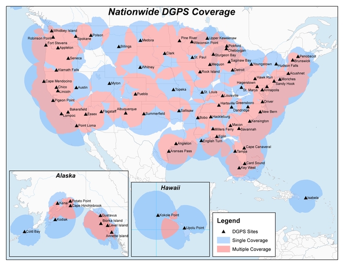
Heartland Corrections Services Now Commercial or WAAS-only
Original NDGPS coverage.
The U.S. Coast Guard, Department of Transportation and Army Corps of Engineers have reduced the number of Nationwide Differential Global Positioning System (NDGPS) sites that will be decommissioned. The course correction keeps a coastal and Mississippi River network of stations largely intact, while discontinuing inland services.
Last year at this time, the agencies sought public comment on a proposed shutdown of 62 of 84 NDGPS sites.
“After a review of the comments received, we have reduced to 37 the number of NDGPS sites to be shut down, nine of which are USCG Maritime sites and 28 of which are DOT inland sites,” the notice reads. “The NDGPS system will remain operational with a total of 46 USCG and USACE sites available to users in the maritime and coastal regions.”
Graphic depicting NDGPS coverage after site reductions. (U.S. Coast Guard)
Public use of NDGPS, never robust, has declined in large part due to limited availability of DGPS receivers. Many users and applications, particularly in precision agriculture, have shifted to commercially provided services or Wide Area Augmentation System (WAAS) corrections instead.
NDGPS coverage is maintained in major maritime ports and waterways. See www.federalregister.gov for a list of sites to be decommissioned. Termination of the broadcast signal is scheduled to occur by Aug. 5.
OCX Deep Dive Finds Progress, Need for Funds
The Pentagon seeks $39.2 million from Congress to speed the next-generation GPS ground control system (OCX) towards completion. Without the infusion, OCX would be delayed an additional four months and cost $90 million more to complete, the Pentagon said.
The embattled OCX showed progress in its July 7 quarterly review, according to an Air Force statement. DOD officials and Lt. Gen. Samuel Greaves, Space and Missile Systems Center commander, concluded Raytheon has made progress implementing critical changes.
On June 30, OCX exceeded baseline cost estimates by at least 25 percent, triggering a Nunn-McCurdy breach and potentially halting all work. Further OCX review will wind up in October. The Pentagon announced in 2015 that it was delaying initial OCX operations for the ground system until July 2021.
GPS III satellites. which may first launch in 2017, cannot use their full capabilities with the current ground control system, but the Air Force plans to use a retrofit to work with the GPS III designs until OCX is operational. See gpsworld.com/updatesyndrome for more details.
Galileo and the Brexit Effect
Tension Grows over the Public Regulated Service
By Tim Reynolds, European editor
UK involvement in the European Space Agency (ESA) should be unaffected by Brexit — the UK leavetaking, as yet undetermined in its details, from the European Union. ESA is a separate institution from the EU. However, one could argue that non-EU-membership might diminish the UK voice and could require a higher financial contribution.
Bids for the next Galileo satellite purchase contracts were due in mid-July, and the European Commission indicated that it will consider them purely on commercial terms. Airbus Defence and Space and Thales Alenia Space were expected to bid, as was the incumbent supplier of the first 22 satellites, OHB SE of Bremen, Germany, with Surrey Satellite Technology Ltd. (SSTL) of Britain as OHB’s satellite payload developer.
The EU has historically been averse to non-EU companies taking major roles in Galileo, and the immediate question is whether the EC could accept an SSTL-built payload that would not be launched until after Britain’s exit is complete.
Paul Verhoef, ESA’s director of navigation, said he will manage the competition as if Brexit had not occurred, with no discrimination against British bidders. Marco R. Fuchs, chief executive of OHB, said OHB would continue the front-line role for SSTL.
Britain could negotiate a security similar treaty similar to one reached by Norway and the EU, that could become effective on the date of Britain’s departure.
If I were a betting man, I’d still wager the house on the incumbent consortium winning the contract to provide the remaining satellites required to provide a sustainable, 24/7 operational constellation for first-generation Galileo. There would, in my opinion, be an unwarranted technical risk in doing anything else.
However, for the next generation it is open season, of course.
PRS at Risk. The real worry must be for the Public Regulated Service (PRS). This is the unique feature of Galileo that is of great interest to civil and military authorities in Europe and beyond, due to its more robust encrypted signal and its potential anti-jamming and spoofing characteristics. Currently, PRS will only be available to EU Member States. However, other countries, including the U.S. and Norway, have indicated that they would love to be able to use it as well. No final decision on this has yet been made.
The loss of the automatic right to access PRS would be damaging to the UK, and potentially to the full Galileo deployment timetable, as the country is currently host to the back-up Galileo Security Monitoring Centre (GSMC) — an essential part of PRS infrastructure — and I cannot see any part of the PRS infrastructure being left in a non-member state. If the centre must be relocated, then deployment of the full service could be delayed.
In addition, UK involvement in research and innovation activities around PRS may be curtailed, even if other work on Galileo projects is not.
UK a PRS Leader. The UK has been a leader in developing PRS applications. Nottingham Scientific Limited (NSL) recently demonstrated cloud-based PRS applications including implementation of PRS authentication for an offender tag, done using live Galileo (and GPS) signals. The demonstration provided real-time authentication flag generation, release and delivery to users. A second demo used cloud-based PRS in a proof-of-concept remote, unattended timing station where the primary user requirement was 100-percent confidence for the validity of signal. A third demonstration illustrated the use of cloud-based PRS on a drone.
Dual-Use Debate
PRS was also a major talking point at the European Space Solution event in The Hague in May. A panel on Space and Security noted that despite the fact that Galileo is marketed as a civil controlled GNSS, “dual use” is becoming a potentially divisive area for debate.
Rini Goos from the European Defence Agency (EDA) said that the EU needed space systems to be able to “intervene successfully,” and that space strategy needed to support Member State defence capabilities. This meant that the next generation of EU space systems must have dual-use capability. NATO is entrusted with external defence of the EU, but the commission also needs to be able to provide defence, not just consume it, he concluded.
The current chairman of the Galileo Security Accreditation Board is a UK citizen, Jeremy Blyth. He said: “Space and security, security and space. Whichever way we say it, what is clear is that the two are inextricably linked together.” He believes that to ensure security, it must be “designed in from the beginning.” Security is an enabler, rather than a barrier, he claimed.
He also believes that PRS gives the EU a real and competitive edge in secure positioning.
However, he indicated that there is a need to think deeply and have a rational debate about dual-use systems and, in particular, about the interface between civil and military use.
Clearly, there is a growing tension with regard to overtly military use of Galileo both now and in future generations of the system. Although a largely philosophical debate, given who in reality will be controlling and using PRS within many Member States, many European and national policy makers will want to retain the “purity” of Galileo as a global positioning system under fully civilian control.
PRS Workshop
Security was also a key feature of the PRS workshop organised by the Netherlands EU Presidency toward the end of European Space Solutions. Ger Nieuwpoort, director of the Netherlands Space Office (NSO), reminded the audience that “For civil authorities, PRS provides the same level of security for Member States as the military in GPS.”
Bart Banning of the Netherlands Institute of Navigation asked “How will we use PRS?’” In terms of its use for protecting critical infrastructure, what if the owner of the infrastructure was a private company? Should it be granted access to PRS or have to make do with the Galileo Commercial Service, a.k.a. PRS-lite?
He also pointed out that PRS was no more protected against jamming than any other GNSS. And, currently, it was “not good for in-building, underground or underwater.”
He thought PRS could be a great time provider, but probably also needs ground transmission, possibly via legacy radio towers. However, he saw the “killer app” for PRS being asset tracking, such as for diamonds, VIPs or prisoners. He also agreed that for many EU countries, the ministry of defence will be overseeing PRS services. “PRS is a good and unique addition to GNSS — but not the answer to all our needs.”
The U.S. Senate Armed Services Committee withheld the full amount requested by the Pentagon for Fiscal Year (FY) 2017 for OCX, the Next-Generation Operational Control System (ground control) for GPS, heretofore deemed necessary to operate the next generation of satellites, GPS III. The Pentagon had asked for $394 million in the upcoming funding cycle, to enable Raytheon to continue work on the program.
If allowed by Congress to continue, OCX may cost as much as $5.3 billion, and there is no certainty that the bill will not rise further.
The Senate committee will not release the $394 million until the Defense Department complies with the requirements of the Nunn-McCurdy Act governing defense programs. Otherwise, Congress could act to terminate OCX.
The terms of the Act now require the Secretary of Defense to conduct an in-depth review and then state that the program is essential to national security, is more important than other programs that will have to be cut to accommodate its cost overruns, and that there are no acceptable alternatives.
From the Defense Department point of view, the new GPS III satellites are essential because of, among other things, their signals’ improved resistance to jamming and cyberattack, an oft-cited peril in the modern global security scenario.
How GPS III could be launched — the first satellite is scheduled for sometime in 2017 — and operated without OCX is not entirely clear, although in February, Lockheed Martin received a $96 million contract to provide contingency control operations for the first GPS III satellites upon launch because OCX won’t be ready. Raytheon and the U.S. Air Force announced a month ago that OCX “successfully passed the first formal qualification test milestone” needed to check out the system and for the early monitoring of satellites in orbit. That “validates the maturity of the OCX launch and checkout system,” according to a statement by Bill Sullivan, Raytheon’s OCX program director.
Raytheon won the OCX contract in 2010 with a bid somewhat more than $1.5 billion. The Air Force recently made its FY 2017 budget request for $393 million as part of an overall anticipated program cost of $4.82 billion. However, a Bloomberg news report states that the total cost may have risen to $5.3 billion.
Galileo Launch and Production
At press time, the latest pair of Galileo satellites was expected to launch into orbit on May 24: the 13th and 14th satellites in the constellation.
A second launch is planned for this fall, carrying four satellites aboard a customized Ariane 5 for the first time. This would bring the count to 18 Galileo satellites in orbit by the end of the year.
Final Payload Delivered. Surrey Satellite Technology Ltd. in the United Kingdom has delivered the 22nd Galileo navigation payload to prime contractor OHB System in Bremen, Germany. This is SSTL’s final payload under Galileo Full Operational Capability (FOC) Works Orders 1 and 2.
Europe’s 13th and 14th Galileo satellites lifted off at 08:48 GMT from Europe’s Spaceport in French Guiana atop a Soyuz launcher. (Photo: ESA)
BeiDou 30 over 5
China plans to launch 30 Beidou navigation satellites during the five-year period 2016–2020, said Ran Chengqi, director of the China Satellite Navigation Office, during the China Satellite Navigation Conference in early May.
This would realize the country’s three-step strategy to build a global navigation system by 2020. A batch of 18 satellites will be launched before 2018. China and Russia have agreed to make BeiDou and GLONASS compatible, and BeiDou has successfully synchronized its frequency with Galileo, Chengqi added.
The U.S. Senate Armed Services Committee withheld the full amount requested by the Pentagon for Fiscal Year (FY) 2017 for OCX, the Next-Generation Operational Control System (ground control) for GPS, heretofore deemed necessary to operate the next generation of satellites, GPS III. The Pentagon had asked for $394 million in the upcoming funding cycle, to enable Raytheon to continue work on the program.
If allowed by Congress to continue, OCX may cost as much as $5.3 billion, and there is no certainty that the bill will not rise further.
The Senate committee will not release the $394 million until the Defense Department complies with the requirements of the Nunn-McCurdy Act governing defense programs. Otherwise, Congress could act to terminate OCX.
The terms of the Act now require the Secretary of Defense conduct an in-depth review and then state that the program is essential to the national security, is more important than other programs that will have to be cut to accommodate its cost overruns, and that there are no acceptable alternatives.
From the Defense Department point of view, the new GPS III satellites are essential because of, among other things, their signals’ improved resistance to jamming and cyberattack, an oft-cited peril in the modern global security scenario.
How GPS III could be launched — the first satellite is scheduled for sometime in 2017 — and operated without OCX is not entirely clear, although in February, Lockheed Martin received a $96 million contract to provide contingency control operations for the first GPS III satellites upon launch because OCX won’t be ready.
Raytheon and the U.S. Air Force announced a month ago that OCX “successfully passed the first formal qualification test milestone” needed to check out the system and for the early monitoring of satellites in orbit. That “validates the maturity of the OCX launch and checkout system,” according to a statement by Bill Sullivan, Raytheon’s OCX program director.
Raytheon won the OCX contract in 2010 with a bid somewhat more than $1.5 billion. The Air Force recently made its FY 2017 budget request for $393 million as part of an overall anticipated program cost of $4.82 billion. However, a Bloomberg news report states that the total cost may have risen to $5.3 billion.
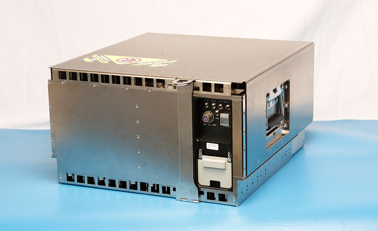
On March 4, Raytheon successfully passed the first formal qualification test milestone for the U.S. Air Force’s GPS Next Generation Operational Control System (GPS OCX). The new system offers significant improvements to the GPS on which the U.S. military and millions of civilians rely, including enhanced availability, accuracy and security.
The event was the Configuration Item Qualification Test (CIQT) milestone for the Launch and Checkout System (LCS). The system provides launch and early orbit checkout capabilities for the modernized GPS III satellites and implements 77 percent of the cybersecurity capabilities for the overall OCX program. The testing was successfully conducted in a representative operational environment with a government-provided GPS III satellite simulator.
The LCS CIQT Run-for-Record was completed more than one month ahead of the plan established in mid-2015, clearing the way for LCS to proceed toward the Factory Qualification Test, the next major qualification event. The FQT test will be at the integrated system level and will take place this summer.
GPS OCX is being developed by Raytheon under contract to the U.S. Air Force Space and Missile Systems Center, which is replacing the current GPS operational control system. The OCX Launch and Checkout System provides an early delivery of a large subset of the overall OCX capability, and will support the GPS III satellite launches.
Congressmen Seek Delay to NDGPS Closings
Four U.S. congressman sent a letter to the Department of Transportation, asking the DoT to delay shutting down Nationwide Differential GPS (NDGPS) sites, a proposal that was posted in the Federal Register.
The congressmen are asking for a delay until the “administration has decided upon and implemented a resilient national positioning, navigation and timing (PNT) architecture.”
“We do not dispute,” they wrote, “the administration’s determination that NDGPS is sufficiently like the Wide Area Augmentation system (WAAS) in its phenomenology and services such that it provides only an incremental benefit to the nation’s PNT architecture. However, some or all of the 62 NDGPS sites (and associated equipment) proposed for elimination could play an important role in achieving the PNT architecture America needs.
“Ceasing transmissions, decommissioning, and disposing of them before we are assured they are not useful to future systems is against our national interest and would not be the best use of government assets and funds.”
Signers were John Garamendi of California, Peter DeFazio of Oregon, Frank Lobiondo of New Jersey, and Walter B. Jones of North Carolina. Read the full text of the letter.
IRNSS Completing
At press time, India was expected to put into orbit its seventh and final navigation satellite on April 28, thus completing the Indian Regional Navigation Satellite System (IRNSS).
IRNSS-1G is expected to launch aboard a Polar Satellite Launch Vehicle (PSLV) rocket from India’s spaceport at Sriharikota in Andhra Pradesh.
IRNSS is designed to provide accurate position information service to users across the country and region, up to an area of 1,500 kilometers.
Jamming on the Borderline
South Korea issued a warning in late March after detecting satellite signal disruptions that appeared to be coming from North Korea. The capital city of Seoul appeared to be the target.
Officials said North Korea discharged a large amount of radio waves to jam GPS signals in the region.
“We’ve detected signs that North Korea has been sending radio waves to the capital area since a month ago to disrupt GPS signals,” a senior government official said, speaking on condition of anonymity. “North Korea had been sending test waves since last month, but today, they discharged the largest amount.”
The disruptions could cause mobile phones to malfunction and affect planes and ships that rely on GPS for navigation. No damage has so far been reported in the military or among civilians, officials said.
Since 2010, GPS disruptions have occurred three times in South Korea, and all have been blamed on the North.
Southern Counter. On April 7, the U.S. State Department confirmed the jamming in a public communique, stating the the jamming was causing signal disruptions to airplanes, ships, and buoys in the area “surrounding Gyeonggi and Gangwon provinces out to about 100 nautical miles.” On April 8, the South Korean government said it would “beef up its system to protect GPS signals” but did not explain how.
South Korea is developing an eLoran system, which would be far more difficult to jam than GPS.
A Long March-3A carrier rocket carrying the 22nd BeiDou satellite lifts off March 30.
22 BeiDou
China launched the 22nd BeiDou satellite into orbit on March 29. BeiDou-22 (or BeiDou-2 I6) was launched at 20:11 UTC (4:11 local time) by a Long March-3A rocket from the Xichang Satellite Launch Center.
China launched the 21st BeiDou satellite on Feb. 1, the second in a series of BeiDou launches scheduled for 2016. The BeiDou constellation is planned to be completed in 2020.
The new satellite, the sixth BeiDou-2 IGSO, will be used to replenish the current operating regional system.
The satellite, after entering its designed work orbit and finishing in-orbit testing, will join others already in orbit and improve the stability of the system, preparing for BDS to offer global coverage.
After landing in French Guiana, the 13th and 14th Galileo satellites, still within their canisters, were unloaded to be taken by road to the Guiana Space Centre. (Photo: ESA)
Next Pair Prepped for Galileo
The latest pair of navigation satellites has reached Europe’s Spaceport in French Guiana, according to the European Space Agency (ESA). This starts a new Galileo launch campaign that will culminate in a May 24 launch of the 13th and 14th satellites in the constellation.
A second launch is planned for this fall, with four satellites carried aloft on a customized Ariane 5 for the first time, bringing the count to 18 Galileo satellites in orbit by the end of the year.
The pair of satellites left ESA’s technical centre in Noordwijk, the Netherlands, on April 4, cocooned within protective air-conditioned containers. They were then driven to Luxembourg Airport, where they were loaded aboard a Boeing 747 cargo jet for a dawn takeoff the following morning.
The satellites touched down at Cayenne — Félix Eboué Airport in French Guiana at 11:15 a.m. local time on Tuesday. Still within their canisters, they were driven to the Guiana Space Centre and unboxed that evening within the cleanroom environment of the centre’s S1A payload preparation building. A fit check is scheduled next, to ensure the satellites can be attached to the dispenser.
ESNC 2016
The largest international competition for the commercial use of satellite navigation once again seeks outstanding ideas and business models, with prizes worth a total of €1 million in more than 25 categories.
The deadline for submissions to the European Satellite Navigation Competition (ESNC) is June 30. The official website provides all relevant information on prizes, partners, and terms of participation. The ESNC is geared toward individuals and teams from companies, research facilities and universities around the world.