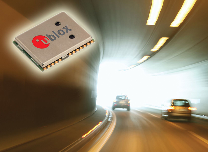
u-blox’ NEO-M8L module with 3D ADR technology and integrated sensors provides accurate vehicle position regardless of satellite visibility. (Image: u-blox)
U-blox has collaborated with Molex on the Modular Automotive Connectivity (MAX) Platform for intelligent vehicles.
The NEO-M8L and TOBY-L4 modules, which are built into the MAX connectivity platform, support the reception and transmission of data over the mobile network to the backend, enabling mobile internet access, in addition to supporting positioning. The solution can determine the position not only via GPS but also via Galileo, Beidou and GLONASS.
Molex is a Tier 1 system integrator and supplier of high-speed networking, datacom, rugged industrial and automotive solutions that enable innovative architecture design and development for the intelligent vehicles.
Molex will demonstrate MAX in booth 151 at ELIV Oct. 16-17 in Bonn, Germany.
The automotive-grade GNSS module NEO-M8L supports positioning, so that the ECU knows exactly where the vehicle is at all times. The solution can determine the position not only via GPS but also via Galileo, Beidou and Glonass. As a result, MAX can be deployed globally and offers a flexible and scalable solution for worldwide mobility providers, OEMs and system suppliers.
TOBY-L4 supports the reception and transmission of data over the mobile network to the backend, enabling mobile internet access.
MAX offers high-quality vehicle networking for both traditional and new mobility providers. MAX is suitable for small series, such as vans or targeted innovative EV projects. As a central node in the vehicle, MAX enables both internal and external networking. The solution is flexible, scalable and is an open software concept, fulfilling important requirements of the dynamic mobility market, Molex said in press release.
“MAX further supports our commitment to providing next-gen connectivity in the car for the entire market, not just a luxury for premium automakers. Molex innovations and expertise are driving solutions that are changing the automotive landscape to allow our customers accessibility,” said Dietmar Schnepp, product director for vehicle communication devices, Molex.
“We are delighted to work with a world leader in the automotive market such as Molex and proud to see two u-blox modules at the core of the new MAX connectivity platform,” said Andreas Thiel, head of Product Centers and co-founder of u-blox. “This collaboration demonstrates u-blox’s dedication to providing automotive customers with best-in-class positioning and wireless communications solutions.”
MAX can be tailored to the customer’s requirements through individual configuration. The platform combines quality of state-of-the-art communication technologies with the necessary degree of standardization for cost control.
In addition, the individual modularization enables a short time-to-market compared to tailor-made solutions. This path is the ideal alternative for telematics service providers who can use MAX as the basis for a backend connection, as well as for the development of various applications.
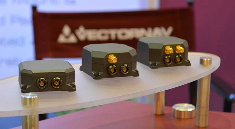
VectorNav Technologies’ tactical series line of inertial measurement units (IMUs) and GNSS-aided inertial navigation systems (GNSS/INS) have completed independent testing for MIL-STD-810G, DO-160G, MIL-STD-1275E and MIL-STD-461.
Completion of the MIL-STD and DO-160 qualification tests proves the robustness of the tactical series to a range of temperature, shock, vibration and other environments, as well as conformance to numerous electrical interface and EMI standards.
The testing demonstrates an advantage of the tactical series for defense and aerospace applications. Other advantages are the modules’ SWAP-C (size, weight, power and cost) and performance characteristics.
“There is high demand for dependable, tactical-grade navigation solutions that perform in challenging environmental and operating conditions,” stated VectorNav Director of Sales and Marketing Jakub Maslikowski.
VectorNav’s tactical series includes the VN-110 IMU/AHRS, the VN-210 GNSS/INS and the VN-310 GNSS-compass aided GNSS/INS.
VectorNav’s new Tactical Series includes the VN-110 IMU/AHRS, the VN-210 GPS/INS and the VN-310 dual-antenna GPS/INS. (Photo: GPS World)
The products include an onboard tactical-grade IMU (<1˚/hr in-run gyro bias stability), along with VectorNav’s proprietary filtering, INS and GNSS-compass algorithms.
The products offer 1 to 2 mrad attitude performance in compact, rugged enclosures and include a 10-pin auxiliary port for integration with external real-time kinematic and SAASM-based GNSS receivers, as well as higher-performance IMUs.
Testing for the MIL-STD and DO-160 standards was performed by independent, certified testing companies in Plano, Texas, and Huntsville, Alabama.
Septentrio and CORE partner up to develop a GPS/GNSS receiver which will make use of Japan’s Centimeter-Level Augmentation Service (CLAS). CLAS corrections are broadcast directly via QZSS constellation to enable high-accuracy positioning across Japan.
Septentrio, a designer and manufacturer of high-precision GNSS technology, and CORE, a Japanese system integrator with extensive experience in GNSS, are jointly developing a receiver that can use the Centimeter-Level Augmentation Service (CLAS) of Japan’s Quasi-Zenith Satellite System (QZSS).
Septentrio’s multi-frequency GPS/GNSS receiver AsteRx4 will be used as a platform for the development of CLAS functionality. Septentrio receivers already track the L6 signal and can use QZSS for increased positioning availability and reliability.
CORE’s know-how will be instrumental for the deployment of CLAS on Septentrio receivers. The two companies are planning to launch their CLAS-enabled receiver in January 2020.
Japan’s CLAS is a self-augmentation GNSS correction service. Without the need for a ground link, it allows real-time kinematic (RTK) centimeter-level positioning all over Japan with convergence times of less than a minute.
It does this by broadcasting GNSS corrections directly via QZSS satellites, also known as Michibiki. These corrections are generated from the dense network of reference stations operated by Japan’s Geospatial Authority.
The two companies have also entered into a distribution contract that allows CORE to sell Septentrio high-precision positioning technology, including CLAS-capable GNSS receivers, in the Japanese market.
The new CLAS-enabled receiver will also incorporate Septentrio’s Advanced Interference Mitigation (AIM+) technology. In busy urban environments electromagnetic waves can interfere with GPS and GNSS signals.
AIM+ offers protection against such interference resulting in faster set-up times and robust continuous operation.
“QZSS Centimeter Level Augmentation Service has been limited to evaluation phase up till now. Realizing CLAS on Septentrio’s multifunctional, high-quality, cost-competitive platform allows our customers to finally use QZSS in their applications,” emphasized Takahiro Yamamoto, Director of GNSS Solution Development Center at CORE Corporation. “Galileo High Accuracy Service (HAS) is expected to start in 2020, so the demand for high accuracy GNSS receivers is also expected to increase. By complementing CORE’s QZSS technology and Septentrio’s Galileo technology, we can provide competitive products to global customers.”
“CLAS is a first-of-its-kind service which will contribute to the proliferation of high accuracy GNSS applications in Japan. Europe is also taking similar initiatives with their Galileo High Accuracy Service (HAS),” commented Neil Vancans, Director of Global Sales at Septentrio. “We are excited to enter into an agreement with CORE to enable the support of CLAS on our receivers. CORE’s expertise allows us to get the best out of CLAS and to follow new developments in QZSS evolution. Moreover, CORE’s expertise in system integration will allow us to tackle new markets in Japan.”
We used to divide GPS receivers into consumer grade, resource grade and survey grade. Have these categories been replaced by a continuum of GNSS capabilities?
Clem Driscoll
“In the U.S. commercial telematics market, GPS remains the primary source of location data, with very little reliance on other GNSS networks. A bigger issue is the generation of cellular networks used to transmit GPS data, with 3G network sunsets pending and 5G on the horizon. As autonomous commercial vehicles become closer to a reality, multiple GNSS networks and differential techniques will become essential. These solutions are currently in development.” Clem Driscoll
C.J. Driscoll & Associates
Greg Turetzky
“No. These categories still define important hardware distinctions (such as antenna) and required correction services that define the achievable specifications. Although they all have correlators, they have very different architectures; however, resource and survey have a blurrier line.” Greg Turetzky
Consultant
Members of the EAB
Tony Agresta Nearmap
Miguel Amor Hexagon Positioning Intelligence
Thibault Bonnevie SBG Systems
Alison Brown NAVSYS Corporation
Ismael Colomina GeoNumerics
Clem Driscoll C.J. Driscoll & Associates
John Fischer Orolia
Ellen Hall Spirent Federal Systems
Jules McNeff Overlook Systems Technologies, Inc.
Terry Moore University of Nottingham
Bradford W. Parkinson Stanford Center for Position, Navigation and Time
Tallysman GNSS has added three new antennas to its Helical antenna line.
Released earlier this year, the helical antenna line provides unprecedented performance in a lightweight, compact form factor.
The line now extends beyond dual-band GNSS and Iridium support to also include single and triple GNSS frequency bands.
Tallysman helical antennas are designed for applications that require high performance and versatility, with an absolute minimum of weight, such as unmanned aerial vehicles (UAVs).
In addition to the HC600, HC871 and HC872, the expanded helical antenna family now includes:
the single frequency HC771
the dual- frequency (plus L- band corrections) HC882
the triple band (plus L- Band corrections) HC975.
The table below lists the complete Tallysman helical Family of antennas.
LORD Corporation has released the latest version of its SensorConnect sensing software, featuring significant updates that support sensor management and data collection and visualization for MicroStrain inertial products.
The update is designed to fully replace the inertial data collection and visualization capabilities in MIP Monitor. MIP Monitor will continue to be available on the website, but will no longer be updated to support new products.
“We’re excited to support users with a desktop software solution that provides a better experience for our inertial users,” said Justin Bessette, manager, Technology and Innovation, LORD Sensing, MicroStrain. “It is important for us to provide users a single tool to collect data and visualize output from both wireless and inertial product lines, side-by-side.”
In previous updates, SensorConnect offered basic support for inertial products. Release 12.0.9 marks the inclusion of all features necessary for inertial users to fully migrate from MIP Monitor to SensorConnect. Users will find all MIP Monitor features available in a more modern and flexible interface, with improved feedback. SensorConnect users will benefit from regular updates, new features and user experience improvements. Additional updates featured as a part of 12.0.9 include storing and displaying matrix, quaternion data and storing, and displaying data valid flags.
New features important for inertial users who are new to SensorConnect include:
Inertial Save/Load Settings (v10.4.9)
Packet Monitor (v9.17.4)
Record Packets to File (v10.4.9)
Support for Double-Precision (v10.0.8)
Initialize/Reset Estimation Filter (v9.9.2)
Initialize/Reset Estimation Filter screen added to enable inertial users to more easily configure, initialize and troubleshoot the device’s estimation filter
Documentation for inertial customers and release notes have been added to the MicroStrain website.
SensorConnect for MIP Monitor Users is designed for inertial users who are accustomed to using MIP Monitor for configuration, sensor management, data monitoring and data collection.
SensorConnect offers the capability to accomplish the same tasks with additional functionality compared to MIP Monitor. Current MIP Monitor users should switch to SensorConnect, the company said.
Trade wars may be THE only serious limiting factor
The GNSS chip market worldwide is projected to grow by $2.7 billion, guided by a compounded growth of 8%, to 2025, according to ResearchandMarkets. Other market reports cite “huge growth” and “strong development” in GNSS-related markets such as simulators, aviation and defense. We can count ourselves lucky — or remarkably prescient — to be part of such a robust industry, in such uncertain times.
The world conquest by smartphones, smart cities and the internet of things (IoT) will strongly support this market growth. Also on the horizon is the rising tide of GPS-enabled vehicles, putting automotive telematics on the road to assisted-driver and ultimately autonomous driving.
M&A. Meanwhile, the fast pace of mergers and acquisitions among manufacturers and integrators will strengthen the GNSS economy and propel it even higher. Such interactivity will bring higher revenue shares to key players as well as support overall profitability increases to come.
Accurate monitoring of operations and assets; the astonishing rise of drones to active roles in many industries; and the constant innovation and imagination churning out new products, solutions and augmented services — all will consolidate the strength of our remarkable economy. The much-heralded arrivals of BeiDou and Galileo fully upon the scene will only make the immediate future stronger for our industry.
Chart: GPS World
PNT Broadly. Where GPS, GNSS, and multi-GNSS go, they carry other positioning technologies along on their coat tails: inertial, signals of opportunity, Wi-Fi, ultra-wideband and more. The growing pie is certainly big enough for all to get a large share.
That’s not to say there are no barriers to growth, no clouds on the horizon. Licensing, laws and regulations will, as ever, constrict growth. This is not always a bad thing. Controlled growth and wise use benefit us all, and prevent runaway bubbles that can burst for lack of proper internal support.
Mapping. Meanwhile, a host of well-established businesses and nascent enterprises exploit the increased interest in location-based information as an enabler for many consumer, organizational and governmental services. This means that mapping and all manner of technologies associated with it — laser, lidar, infrared and more — may grow at even faster rates.
A brave new world awaits. Once GNSS is integrated with artificial intelligence, there’s no telling where we’re headed.
Of the many uncertainties across the globe, economic warfare poses a greater risk to GNSS than does military conflict. The latter, cynically enough, will actually benefit the industry in the short run, though its effect may chill in the long run.
Chart: GPS World
Trade. One of the biggest questions confronting the industry now is whether the trade and tariff war between the U.S. and China will continue, and what effect it will have. Experts disagree widely on both questions, though almost all of them, except the leaders who are supposed to listen to them, agree that it’s generally a bad thing.
As was stated in these pages at this time last year, if business confidence falls as a result, global output could also drop.
Opportunities Outweigh Obstacles
Industry leaders confront spectrum issues, jamming
In contrast to the rosy forecast on the previous page, serious issues confront the GNSS market. None of them are more serious, thornier or difficult to resolve (despite the many solutions offered) than spoofing and jamming.
Like a tragic hero, GNSS carries a potentially fatal weakness within its strength. To be ubiquitous and highly precise, the signals come from space. Coming from space, they are weak and susceptible to malicious meddling.
Other political and technological obstacles put pressure on the GNSS industry, and therefore upon the whole PNT industry. GNSS always will be the backbone, the center core holding together various adjunct positioning, navigation and timing technologies.
These issues, following closely on the heels of spoofing and jamming, include but are not limited to: spectrum competition and spectrum management; cybersecurity; privacy; net neutrality; national security export controls; product liability; and failure, however temporary, of GNSS systems.
We’ve seen this last most recently with Galileo, but all the GNSS have suffered such setbacks, and surely will again. The nature of the response to each occurrence is the most critical factor.
Keep on the Sunny Side. However, the opportunities far outweigh the obstacles. The greatest opportunities always arise from the greatest asset that the industry possesses: intellectual capital.
Many of the opportunities are cited on the previous page. While high precision will continue to lead the innovation charge and provide the highest profit margins, the smartphone and the automobile will increasingly take up the MVP (most valuable positioner) role within the industry.
Market Intelligence. All these factors make unprecedented demands on management attention and agility. Executives need good market intelligence to keep abreast and ahead of fast-developing research and development trends, market shifts, developments in neighboring or competing technologies, and protectionist tariffs and import/export controls.
Insight provided by all regions, sectors and job titles
This year’s State of the GNSS Industry Survey provides insight from around the globe.
Just over half our respondents work for companies or organizations headquartered in North America; 15% are from Asia-based operations; roughly 10% each for enterprises in Europe and Latin America; slightly less for the Pacific region; and the rest of the replies scattered across Africa, the Middle East and Russia. Truly an international sampling!
Chart: GPS WorldChart: GPS WorldChart: GPS WorldChart: GPS World
Demographics. For job titles, we drew in-depth data from:
owner/president/CEO, 21%
engineer, 20%
general, product or program manager, 19%
other, mostly surveyors or GIS analysts, 18%
researcher, 10%
vice president, CTO, COO, CFO or similar, 6%
sales and marketing, 5%
Sector. The intelligence in the following pages accumulated from these industry verticals:
survey and high precision, 29%
defense, security, government, 19%
mapping, data acquisition/processing, GIS, 14%
satellites, signals and simulation, 9%
machine control, precision agriculture, or transportation (non-autonomous), 6%
Drones continue to move further into everyday life and activity as they become more involved in applications that touch almost everyone. Previously a curious novelty, now unmanned aircraft are almost commonplace.
Real Estate. Suppose you are buying a new house. Almost all the exterior home pictures and video on real-estate websites come from dones. The high-definition photo capability of any commercially available drone is well up to providing great panoramic aerial shots — now virtually required to market homes.
Suitable UAVs and their operators are either readily available, or real-estate agents are taking on the job, buying and flying the equipment and managing the video-processing software themselves. Approvals for regular real-estate operations using drones now can be more readily obtained The objective is near real-time approval using the U.S. FAA’s Low Altitude Authorization and Notification Capability (LAANC) system, with drone operations provided by an expanding list of independent UAS Service Supplier companies, cleared and qualified by the FAA to provide commercial drone operations.
Crop Monitoring. In agriculture, it is virtually expected that a large farm operation will be on a crop monitoring/maintenance program that entails regular drone data-collection flights and automated processing of geo-tagged photographic, thermal and laser crop images. An initial baseline set of images establishes the starting point for the program, and then analysis identifies crop weaknesses. A fertilizer/treatment “prescription” is then drawn up to address deficiencies. After applications throughout the growing areas, follow-up drone monitoring checks whether growth rates have improved or if more remedial action is necessary.
The cycle continues throughout the growing season. A number of large and small companies offer turnkey services to farmers, or farms themselves run subsets of this UAS-based operation.
Construction and Inspection. Mining and construction now also have drone services that gather and process image data to automate significant parts of the process, as does surveying and geospatial information services (GIS).
Facility inspection using drones follows the agriculture model, with initial overflights establishing a baseline status record against which subsequent image data is compared.
Indoor automation with drones also has enabled a huge reduction in time spent in frequent physical inspection of tanks, pressure vessels, holds and more. It also has greatly improved safety for inspection personnel who no longer have to crawl through extensive, potentially toxic environments, such as the containment vessels at Fukushima Daiichi.
News and Events. News gathering has been enhanced by the use of drones. Aerial videos capture the news quickly and inexpensively compared to helicopters, and provide overview situational awareness for the news audience. In the same vein, we can add crowd surveillance at large events, where higher levels of security are required, such as the 2019 FIFA Women’s World Cup in Paris.
Chart: GPS World
Package Delivery. One classic drone application — package delivery — still hasn’t arrived fully, but many trials have been underway for several years, particularly for the delivery of medical supplies. It seems now that UPS is making a significant effort to qualify a UAS system that meets existing manned delivery standards (FAA Part 137 operations) by the end of this year. Wish them luck: there are many elements to prove and demonstrate for an unmanned delivery system, particularly in populated areas.
Security and Defense. Extensive use of drones in local and national policing and security operations has become almost commonplace, too. Cost-effective and easy-to-fly UAV systems have begun to replace manned surveillance helicopters, with police forces discovering significant improvements in reaction speed and affordability.
And, of course, the use of drones by defense forces worldwide has expanded greatly. Most people can picture the familiar silhouette of the General Atomics Reaper as their image of what a military drone looks like. Many people might even now know where the Straight of Hormuz is located, following the world-wide reports of an apparent Iranian attack that brought down a Northrop Grumman RQ-4 Global Hawk, followed by the takedown of one or two Iranian drones by the USS Boxer in the same area. Drones would now seem to be predominantly associated by Joe Public with a level of military aerial presence — perhaps more so than in any civilian applications.
New and different configurations of UAS continue to rapidly emerge for any and all applications in both the civil and military sectors. Now that we have operating regulations for small UAS in the U.S. and elsewhere around the world, cost-effective commercial uses abound and support new and existing tasks, and the military is rapidly creating new variations to assist or replace manned ground, navy and airborne forces. Large and small investments in artificial Intelligence for drone automation seem to be announced almost daily – so we can expect some independent drone capability to emerge over time.
There is only much, much more to come.
TONY MURFIN is a GNSS aerospace consultant with several decades experience at leading companies in the GPS/aviation and OEM sectors.
SBG Systems has announced a major firmware update for the Ellipse product line. New features have been added to version 1.7 to enhance performance of the sensor.
Automotive package. New features were developed to better answer needs of the autonomous testing and driving markets. These features include:
CAN odometer. Users now have the choice to connect an external odometer (DMI) with pulses or use their car odometer with velocity information. During the installation, users can enter a rough “resolution.” Then, SBG’s inertial sensor refines the odometer installation parameters to automatically obtain the best performance.
New outputs. Included are body velocity and slip angle, which calculates the “drift” angle between the vehicle assumed trajectory and its actual (deviated) trajectory.
Fixed lever-arms mode. For precision applications as well as low dynamics, and reduced warm-up time, the new Ellipse firmware allows users to run the Ellipse Kalman filter with no lever-arm estimation. This will ensure centimeter pass-to-pass accuracy for real-time kinematic (RTK) applications and allow operation in lower dynamics while reducing warm-up time.
To precisely calibrate the lever arms, the use of Qinertia Lite can be used to obtain centimeter precise lever arms. For general-purpose applications, the standard mode of operation that refines the lever arms in real time is still available.
Marine applications. The firmware update provides new features for advanced marine applications.
DVL aiding support. This helps to reduce drifts from the inertial sensor underwater, providing an interesting opportunity for projects such as short subsea navigation with affordable inertial sensors.
New output message (INDYN). INDYN brings support to performance sailing autopilots such as the B&G H5000.
Improved magnetic calibration (sbgCenter). The new sbgCenter embeds a new magnetic calibration algorithm that improves overall performance in challenging calibration while allowing even more difficult calibration conditions. This new calibration procedure also provides improved quality feedback.
The firmware download is protected by a password, the same credentials as for the last version. To request the password, e-mail [email protected].
Digital Matter’s Oyster2 4G battery-powered GPS receives PTCRB approval, AT&T certification and redesigned housing
Digital Matter’sOyster2 is now PTCRB approved and certified for use on the AT&T Network in the United States. With PTCRB certification, operators and device manufacturers are confident of a device’s interoperability with mobile networks.
Designed for tracking non-powered assets for extended periods of time, common applications of the Oyster2 include tracking trailers, bins, hire and rental equipment, shipping containers, boats, bikes, scooters and more.
The Oyster2’s u-blox SARA-R410M modem operates on all major global LTE-Cat-M1 and NB-IoT bands. The device uses concurrent GPS and GLONASS tracking with a 72-channel high sensitivity receiver, and features a 3D accelerometer for G-force detection.
Configurable adaptive-tracking parameters allow the device to sleep when stationary, resulting in industry-leading battery life: up to seven years of life at once daily updates; one year of life at once hourly updates.
The versatile asset tracker can be powered by three off-the-shelf AA lithium batteries, or lithium thionyl chloride (LTC) batteries for enhanced performance and temperature tolerance.
The Oyster2 is now also available in redesigned ultra-rugged housing. Engineered with nylon glass, the IP67 housing is considerably tougher and thicker in key areas, providing increased durability, thermal resistance (the device can reach temperatures up to 185º F/85º C without compromising performance) and chemical resistance.
The device’s mounting tabs and screw holes have also been fortified and repositioned, improving resistance to cracking.
Digital Matter is an original equipment manufacturer of award-winning GPS and internet of things (IoT) devices and tracking software. Digital Matter devices are resold through 500 channel partners across the world and deployed in more than 110 countries.
PCTEL Inc. has released an antenna that combines precision multi-constellation GNSS with high-performance LTE, sub-6 GHz 5G, Bluetooth and Wi-Fi connectivity.
The Coach II antenna with GNSS L1/L2/L5 is designed to provide greater precision and reliability for advanced rail communications systems, enabling everything from next-generation positive train control (PTC) to passenger Wi-Fi.
“Precise timing and tracking information is critical not just for rail, but for a variety of fleet, public safety, and industrial IoT [internet of things] applications,” said Rishi Bharadwaj, PCTEL’s chief operating officer. “PCTEL’s antenna technology enables our customers to deploy new technologies with confidence,” added Bharadwaj.
PCTEL is displaying its Coach II antenna with GNSS L1/L2/L5 on Sept. 22-24 at RSSI C&S Exhibition in Minneapolis, Minn. It is available to order now for shipment in early November using part #GL125-DLTEMIMO.
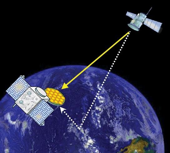
Your phone or satnav receiver routinely picks up signals from navigation satellites in order to tell you precisely where you are. But have you ever thought what happens to those satnav signals afterwards? A foresighted ESA inventor had the idea of using them as a tool for observing the Earth.
More than 120 satellite navigation satellites are in orbit, making up multiple constellations including Europe’s Galileo system, sending down a continuous rain of satnav signals for the benefit of users worldwide. Just like visible light, these microwave signals go on to reflect off Earth’s land and sea surfaces.
The traditional attitude to these reflected signals is to see them as something of a nuisance — known as multipath, they can confuse satnav receivers and reduce their overall accuracy.
ESA microwave engineer Manuel Martín-Neira, inventor of the PARIS reflectometry concept. (Photo: ESA)
But back in 1993 — at the same time as the US GPS satnav system reached its full constellation of 24 satellites — a young ESA microwave engineer called Manuel Martín-Neira came up with the idea of treating these satnav reflections as a scientific resource instead.
“My head of division asked me to come up with a budget-friendly way of increasing the overall sampling rate to build up a fuller picture of mesoscale phenomena, and that led me to start looking into making use of additional signals of opportunity, chiefly satnav signals.
“The initial reaction was mixed, because the forecast accuracy was not as precise as the ERS-1 altimeter could deliver — but on the plus side there would be a lot of these signals to make use of, and the performance has improved a lot since those early days.”
PARIS, detecting reflected satnav. (Photo: ESA)
Inspiration from reflection
The basic idea of what Manuel christened the Passive Reflectometry and Interferometry System, or PARIS, comes down to a two-sided antenna. As the topmost side picks up a satnav signal from the satellites in orbit, the other side picks up the version of the signal bounced back from Earth.
By comparing this initial, overhead signal with its reflected equivalent using a process called interferometry — measuring tiny differences in signal phases – the extra travel time of this reflected beam can be determined, down to an accuracy of less than five centimetres, determining sea height and sea ice thickness.
Additional amplitude waveform processing can deliver further data on wind and wave measurements over the ocean, and soil moisture and biomass over land.
Satellite reflectometry has since grown into a thriving field. This summer, Manuel attended the latest international workshop on the method he first devised 26 years ago.
Reflectometry reaches space
“It’s been fantastic to have experimental evidence, and that’s really been made possible by the growing availability of smaller satellites,” explains Manuel.
“Because satellite reflectometry is a passive form of remote sensing, it makes for an attractive potential payload because it doesn’t need a lot of power to operate. Then one of the results is meteorology data that private companies intend to make money with by delivering to public agencies.”
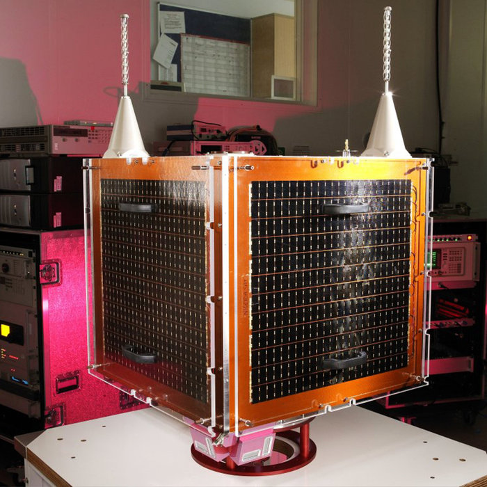
Surrey Satellite Technology Ltd.’s UK-DMC satellite was the first orbital mission with a reflectometry payload. (Photo: ESA)
In 2003, the UK-DMC satellite was the first mission to fly a reflectometry payload, followed in recent years by, for example, the UK’s TechDemoSat-1, NASA’s CyGNSS constellation to monitor hurricanes and the Spire global constellation of commercial nanosatellites.
“These satellites have really given the reflectometry community a wealth of signals, demonstrating what reflections look like over different surfaces including sea ice, forests, and even inland water bodies such as the Amazon River and its tributaries.
“In parts of the ocean near continental masses and within atolls we are seeing reflected signals from very calm waters which resembled a mirror, giving us very high precision down to 1 cm level. Such measurements could potentially complement current altimetry missions, by for instance measuring sea level rise.”
Example of a CYGNSS Microsatellite Observatory. (Image: Southwest Research Institute)
ESA activities taking flight
ESA meanwhile is active on reflectometry in various ways, having developed and tested a steerable airborne antenna called the Software PARIS Interferometric Receiver or SPIR, capable of steering separate antenna beams to build up a rapid surface picture, and differentiating between different signal sources, such as GPS from Galileo.
Manuel adds: “ESA’s GNSS Science Support Centre, based at the Agency’s European Space Astronomy Centre near Madrid, has been taking a keen interest in these activities.”
Missions are also in development, including a dedicated CubeSat with RUAG-Austria and the University of Graz called PRETTY (for Passive REflecTomeTry and dosimetry, which would also carry a radiation detector), and a small satellite pair called FSSCat from Spain’s Universitat Politècnica de Catalunya, backed through the Copernicus Masters competition, seen as a prototype for a future reflectometry constellation.
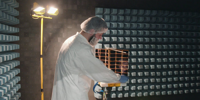
ESA’s Directorate of Telecommunications and Integrated Applications is also working with the Spire company to fly enhanced reflectometry instruments, starting at the end of this year.
One of Spire’s Satellite Manufacturing Technicians (Tomasz Chanusiak) tests the Radio Frequency capabilities of a LEMUR2 nanosatellite in Spire’s cleanroom in Glasgow, Scotland. (Photo: ESA)
When it comes to the thriving state of today’s reflectometry community, Manuel recalls the patenting of his idea as a turning point: ‘Having had this idea, which was not particularly well received, the proposal by ESA’s Patents Group to patent it made all the difference. It gave me a feeling of confidence, that somebody else at least saw the potential of this idea — and the rest is history.”