Averna celebrated its 20th anniversary Sept. 20 as a test and quality solutions provider. Founded in 1999 by a team of three in Montreal, Quebec, Averna has grown to 400+ employees with 10 offices and more than 300 customers around the world.
“I am proud to see what Averna has become,” said Adil Lahlou, one of the co-founders of Averna. “We started Averna by understanding our clients’ manufacturing challenges and now reflecting on the continuing success we’ve had, it’s a reminder that we are still on the right path, particularly with the growth of Industry 4.0.”
Averna’s growth can also be attributed to business alliances. Company founders Kurt Hensen (T&M Solutions NV) and Darren Lingafeldt (Nexjen Systems) both believed that combining more than 100 years of test and quality experience would only benefit their customers and the industry.
“With each company bringing their own expertise to the forefront, different technologies are being exposed to a wider range of clients internationally,” the two said in a press release.
With proficiency in vision, RF signals, optics, precision assembly, robotics and automation, Averna has developed hundreds of unique solutions to service major industries such as medical technology, automotive and transport, and consumer goods and electronics.
Through standalone projects and complete program outsourcing, Averna’s global team has demonstrated its capability to support their customers at every step of the product life-cycle, the company said.
“What makes Averna outstanding is the willingness to consistently evolve and stay in front of our customers’ business needs,” said Francois Rainville, president and CEO of Averna. “It’s our employees’ enthusiasm to understand and tackle customers’ evolving requirements that has kept us ahead for the last 20 years and will continue to through the next 20.”
The new portfolio offers a comprehensive array of GNSS validation technology, as well as signal and PNT data protection through jamming/spoofing detection, suppression and countermeasure solutions.
The capabilities are built on Orolia’s legacy of resilient PNT solutions, together with two key acquisitions completed this year: Skydel Solutions and Talen-X. These companies were selected based on their demonstrated GNSS testing and simulation experience.
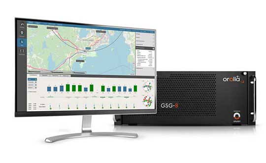
GSG-8, the latest advanced simulator from Orolia, was also introduced to the global GNSS community this week at ION GNSS+. This software-defined simulation solution offers ultra-high performance and unmatched flexibility in an easy-to-use format. GSG-8 was developed to deliver the highest standard of GNSS signal testing and sensor simulation performance, in an upgradable and scalable platform.
“With its scientific precision and advanced simulation capabilities, GSG-8 is revolutionizing the GNSS simulation industry with Orolia’s robust 1000Hz Skydel software engine and COTS software-defined radios,” said Stephane Hamel, director of testing and simulation at Orolia. “GSG-8 is designed for customers that require complex capabilities to validate product and program performance in harsh, high risk environments where failure is not an option- such as government agencies, space programs and specialized commercial programs.”
It can be programmed to simulate operations with multiple GNSS constellations and to incorporate the use of encrypted or proprietary signals. GSG-8 can also be configured for Wavefront and Anechoic chamber simulation protocols to test anti-jam antennas and complete systems, to serve the most challenging program requirements.
The VSP600L VeroStar supports the full GNSS spectrum, as well as L-band correction services. (Photo: Allison Barwacz)
Tallysman has released its VSP600L VeroStar precision antenna at Intergeo 2019, which took place Sept. 17-19 in Stuttgart, Germany.
The VeroStar supports the full GNSS spectrum, as well as L-band correction services. The antenna provides low elevation satellite tracking with a high efficiency radiating element, the company said.
Its performance is suitable for real-time kinematic (RTK) and precise point positioning (PPP) applications. It features a light, compact and robust design. The antenna also has a low axial ratio through all elevation angles providing strong multipath rejection.
According to Tallysman, the VSP600L VeroStar also provides high receive gain over the full GNSS spectrum from low GNSS band (1164MHz to 1300MHz) L-band correction services (1539MHz to 1559MHz) to high GNSS band (1559MHz to 1610 MHz).
The antenna also has a low axial ratio through all elevation angles providing strong multipath rejection.
“The most unique feature of the VeroStar antenna is the high gain at low elevations,” Allen Crawford, director of key accounts at Tallysman, told GPS World at the show. “It can track low elevation satellites with a really high signal level, which is really important for those using correction services coming off of geostationary satellites. So as you go further away from the equator, you’re dealing with some very small link margins and you need those extra up to 4dB higher signal strength that this antenna provides.”
According to the company, it will soon be releasing embedded models of the VSP600L VeroStar.
Trimble has added capabilities to its real-time network (RTN) portfolio, including the Trimble Pivot Platform and the Trimble Alloy GNSS reference receiver.
The new capabilities will enable operators to continue to meet the ongoing demand from surveyors, mapping professionals and precision farmers for accurate, reliable corrections derived from real-time networks.
The announcement was made at Intergeo 2019, the world’s largest conference on geodesy, geoinformatics and land management, taking place Sept. 17-19 in Stuttgart, Germany.
Boosting RTN performance. A well-established network software, the Pivot Platform manages and controls small, mid-size and countrywide GNSS networks. By applying sophisticated atmospheric models to reduce systematic errors, highly accurate GNSS corrections are generated and made available for a wide range of field applications.
BDS-3 now supported
Both Pivot and Alloy now access BeiDou Generation III (BDS-3) signals.
Trimble Pivot version 4.3 has been enhanced to track and store BDS-3 — RTN operators worldwide now have the ability to provide their customers with additional satellite signals to offer even more robust and reliable positioning for their applications. This update also includes a simplified Chinese user interface, providing easy-to-use software operations for Chinese RTN operators.
Released in 2018, the Alloy GNSS reference receiver was designed with the processing power needed to deliver high-quality data from multiple GNSS constellations. Alloy version 5.42 firmware tracks all available and planned GPS Block IIIA L1C and BDS-3 signals, empowering operators with a full GNSS constellation dataset.
“These updates keep the Trimble Pivot Platform and Alloy on a future driven path,” said Mark Richter, strategic marketing director, Real-Time Networks and Services portfolio for Trimble’s Advanced Positioning Division. “Our focus is to continue to deliver enhancements influenced by market demands and advancements in technology, which deliver next-generation RTN hardware and software to our customers.”
The Trimble Pivot Platform and Trimble Alloy GNSS reference receiver updates work in conjunction to provide quality GNSS corrections to network operators and end users.
Trimble real-time networks and services
Trimble RTN networks and services are a widely used GNSS infrastructure solution. Spanning a variety of applications and industries worldwide, Trimble’s hardware is specifically developed for RTN real-world environments while the software integrates seamlessly into the RTN solution for exceptional real-time performance.
The flexibility of Trimble’s solution enables users to collect, manage and analyze complex information faster and easier, improving productivity and efficiency.
Four national organizations join alliance dedicated to furthering GPS innovation, creativity and entrepreneurship
The GPS Innovation Alliance (GPSIA) has added four national organizations representing a variety of sectors. The organizations join GPSIA’s affiliates program by supporting the alliance’s goal of protecting, promoting and further enhancing GPS — one of the world’s most important enabling technologies.
The new affiliates are:
American Council of the Blind (ACB)
U.S. Geospatial Executives Organization (U.S. GEO)
NENA: The 9-1-1 Association
Subsurface Utility Engineering (SUE) Association
“The Alliance has grown in both size and ambition since its inception over six years ago and with increased adoption of GPS-enabled technologies, our dependence on GPS will only continue to grow,” said GPS Innovation Alliance Executive Director J. David Grossman. “Building on the launch of the bipartisan and bicameral GPS Caucus this past March, we look forward to working with these new affiliates in bringing heightened awareness to the critical importance of GPS to our nation’s economy.”
These organizations join GPSIA’s existing affiliates including:
Association of Equipment Manufacturers (AEM)
American Trucking Associations (ATA)
Association for Unmanned Vehicle Systems International (AUVSI)
Boat Owner’s Association of the United States (BoatUS)
General Aviation Manufacturers Association (GAMA)
National Association of Manufacturers (NAM)
National Society of Professional Surveyors (NSPS)
The following are comments from representatives of the newly announced affiliates:
Clark Rachfal, Director of Advocacy and Governmental Affairs, American Council of the Blind (ACB)
“Precise GPS technology is enabling a world where people who are blind may navigate their surroundings with greater confidence and live more independently. The American Council of the Blind is pleased to partner with the GPS Innovation Alliance to ensure this vital technology is available and accessible to all people who are blind in order to increase their economic opportunity and quality of life.”
John M. Palatiello, Founder and President, U.S. Geospatial Executives Organization (U.S. GEO)
“The acquisition, processing, analysis, and application of geospatial data, and its use in geographic information systems (GIS) and other platforms, is greatly dependent on GPS and GNSS. U.S. GEO, representing executives of the nation’s geospatial firms, strongly supports our GPS system and is honored to be part of the GPS Innovation Alliance to assure its continued benefit to the U.S. economy and our quality of life.”
Dan Henry, Director of Government Affairs, NENA: The 9-1-1 Association:
“Locating a 9-1-1 caller used to be as simple as searching a database for the street address associated with the caller’s phone number, but with over 80% of all 9-1-1 calls now coming from mobile phones, tracking down a caller’s location is no longer so easy. When callers are unable to convey their location to 9-1-1, public safety telecommunicators turn to mobile phones’ sophisticated location-finding system; GPS is the foundation of this system. 9-1-1 saves millions of lives every year — many of these lives would not have been saved if not for GPS.”
John Berrettini, President, Subsurface Utility Engineering (SUE) Association
“The SUE Association is comprised of firms, organizations and individuals engaged in the provision of subsurface utility engineering (SUE) services where the role of GPS/GNSS availability and utilization is vital to field data collection, analysis, and processing. Partnering with the GPS Innovation Alliance helps to meet our organizational charge to promote knowledge, best practices, and the exchange of information in the profession; ensure the protection of public health, welfare and safety; and educate clients and other stakeholders of the value and benefits of subsurface utility engineering services.”
The GPS Innovation Alliance was founded by Deere & Company, Garmin International, Inc. and Trimble Inc. The alliance recognizes the ever increasing importance of GPS and other GNSS technologies to the global economy and infrastructure and is firmly committed to furthering GPS innovation, creativity and entrepreneurship by seeking to protect, promote and enhance the use of GPS.
Hemisphere GNSS showcased its next-generation digital ASIC and RF ASIC interference mitigation platforms, and five positioning and heading OEM boards — the first products incorporating these powerful technological advancements.
Hemisphere is showcasing its new boards and technology at the Intergeo expo (hall 3, booth C3.030) and conference in Stuttgart, Germany, and the ION GNSS+ conference (booth 411) in Miami, Florida, both taking place this week.
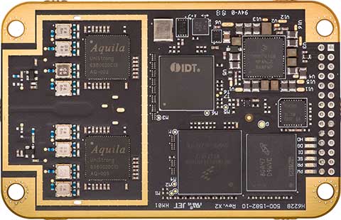
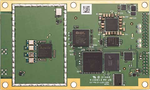
Hemisphere’s Lyra II digital ASIC and Aquila wideband RF ASIC designs optimize performance and provide the ability to track and process more than 800 channels for position-only (the Phantom series boards) and more than 1,100 channels for position and heading (the Vega series boards), the company said.
Phantom 40. (Photo: Hemisphere GNSS)
This new ASIC technology offers flexible and scalable access to every modern and planned GNSS constellation and signal, including GPS, GLONASS, Galileo, BeiDou, QZSS, IRNSS, SBAS and Hemisphere’s Atlas L-band.
Signal support and tracking for AltBOC and BS-ACEBOC, BeiDou phase 2 and phase 3, L5 and QZSS/L6 (L6-D and L6-E) are also available.
The Lyra II and Aquila ASIC technology provides the foundation for a new GNSS receiver chipset architecture that significantly reduces the number of board components, thereby reducing complexity, improving reliability, and dramatically lowering power consumption.
Cygnus interference mitigation. The powerful technology platform also includes Hemisphere’s new Cygnus interference mitigation technology with built-in digital filtering capabilities and spectrum analysis. The new Cygnus technology provides enhanced anti-jamming, interference detection, and mitigation.
“This new technology platform and OEM boards represent significant improvements upon previous generation technology and hardware,” said Farlin Halsey, president and chief executive officer of Hemisphere. “With these outstanding advancements in our core technology and hardware, our customers and OEM partners are future-proofed and have flexibility and scalability with the highest-value access to all modern and planned signals.”
Vega 28. (Photo: Hemisphere GNSS)
The next-generation Lyra II, Aquila, and Cygnus technologies are available with the new Phantom 20, Phantom 34, Phantom 40, Vega 28, and Vega 40 OEM positioning and heading boards.
The Phantom 20, 34, and 40 positioning boards are the first Lyra II-based offerings in a line of all-new, low-power, high-precision OEM boards. They are multi-frequency, multi-GNSS receivers that boast more than 800 channels including access to Hemisphere’s Atlas GNSS global corrections network and offer serial, USB, Ethernet (Phantom 40-only), and CAN connectivity for ease of use and integration.
The Phantom 20 (41 x 72 mm module with 20-pin header), Phantom 34 (41 x 71 mm module with 34-pin header), and Phantom 40 (60 x 100 mm module with 24-pin and 16-pin headers) are significant upgrades for existing designs using these industry-standard form factors and offer power consumption of less than 1.8 W when tracking all signals, including L-band.
The Vega 40 and 28 are the first introductions in a line of all-new, low-power, high-precision, positioning and heading OEM boards. The multi-frequency, multi-GNSS Vega 40 and 28 GNSS receivers offer access to more than 1,100 channels including Hemisphere’s Atlas GNSS global corrections network.
The Vega 40 is a 60 x 100 mm module with 24-pin and 16-pin headers and is the ideal upgrade for existing designs using this industry-standard form factor. The Vega 28 is a 45 x 71 mm module with 28-pin header and is the smallest GNSS OEM heading module ever offered to the geospatial market by Hemisphere.
The GPS World staff is reporting live from ION GNSS+ Sept. 16-20 in Miami, providing news, photos, videos and more. According to show organizers, this year’s conference brings together international leaders in GNSS and related positioning, navigation and timing fields to present new research, introduce new technologies, discuss current policy, demonstrate products and exchange ideas.
Combining data from GNSS and IMUs ensures accuracy during GNSS outages.
Leti, a research institute of France’s CEA Tech, and Orolia have announced a new sensor-data-fusion engine that ensures resilient positioning and navigation even in cases of GNSS jamming or spoofing.
Orolia is a leader in accuracy and performance for terrestrial, aeronautic and naval transportation positioning, navigation and timing applications.
Called FlexFusion, the algorithm technology processes data from GNSS, inertial management units (IMU) and odometers to provide precise positioning in all conditions.
Orolia will present its latest technological developments at ION GNSS+, booth 311, taking place in Miami, Florida, Sept. 17-19.
FlexFusion’s design relies on a modelization of GNSS and IMU (triple-axis accelerometer, triple-axis gyrometer and triple-axis magnetometer) output for synthetic trajectory generation.
The fusion approach exploits Bayesian estimators, such as Kalman filters. The first algorithm was setup on modeling signals, and its optimization relies on an extensive real-life sample database acquired through field test. This process used CEA-Leti’s HYLOC reference platform, which provides a reference positioning of a few centimeters.
More than 100 trajectory samples were collected in urban, suburban, forest and mountain environments with different GNSS outage conditions.
The new positioning technology supports edge artificial intelligence (AI) because the data-fusion algorithm is performed locally to ensure that positioning and navigation information is available locally and is failsafe even in case of jamming or spoofing of GNSS data.
“Recent events have demonstrated that it is possible to change the course of a ship or force a drone to land in a hostile area by simply spoofing GPS signals,” said CEA-Leti CEO Emmanuel Sabonnadière. “The increasing reliance on a GNSS for the execution of military operations and terrestrial, aeronautic and naval transportation requires using positioning and navigation systems that are able to detect GNSS outages and provide resilient position and navigation features.”
A version of FlexFusion that demands less of the CPU implements a loose coupling algorithm that uses GNSS receiver-output positions as entry of the algorithm. An advanced version implements a tight coupling fusion algorithm of GNSS and IMU data that significantly enhances the resilience of positioning and navigation under real-world conditions.
This novel approach enables total control of treatments and filtering applied to raw signals, which increases performance of the fusion. It also improves positioning performance in particular if there are fewer than four GNSS satellites available, or when there are recurrent multi-trajectories, which sometimes occur in urban canyons.
CEA-Leti has licensed the patented FlexFusion algorithm to Orolia.
“Orolia is integrating FlexFusion in a new version of its VersaPNT product, the first compact, all-in-one and resilient positioning, navigation and timing (PNT) system for vehicles and blue force tracking, tactical UAV navigation and marine applications,” said Thierry Delhomme, EMEA general manager, Orolia. “This powerful algorithm helps deliver on the promise of VersaPNT as an always-accurate PNT system that operates in any environment.”
FlexFusion development was supported and partially funded by the Easytech program of IRT Nanoelec, thanks to the French National Program “Programme d’Investissement d’Avenir” ANR-10-AIRT-05.
The u-blox ZED-F9P, a high-precision GNSS module that delivers centimeter-level accuracy within seconds, has been incorporated into the latest electric Tron F90+ fixed-wing unmanned aerial vehicles (UAVs).
Quantum-Systems, a German company that specializes in electric VTOL (vertical take-off and landing) aircraft for civilian use, manufactures the Tron F90+, which is employed in mission-critical logistical activities such transporting emergency blood reserves to remote locations. Other uses include mining and agriculture-related tasks.
Quantum-Systems and u-blox are both exhibiting at Intergeo in Stuttgart, Germany, Sept. 17-20. Quantum-Systems is at booth K1.074, and u-blox at booth L1.025.
The Tron F90+ has a 3.5-meter wingspan and can travel at speeds of up to 160 km/hour with a 100-km flight range. It is the latest addition to the Quantum-Systems eVTOL UAV platform designed for cargo, inspection, survey and mapping, and reconnaissance in adverse conditions. Other models include the Trinity F9, Scorpion and Vector UAVs, all of which feature u-blox F9 high-precision GNSS technology.
In developing the Tron F90+ UAV, the Quantum-Systems engineering team needed accurate enough position data to ensure that VTOL operations would always go smoothly, and the valuable payloads were protected from damage.
Through the multi-band real-time kinematic (RTK) and raw code and carrier-phase data available to the ZED-F9P, the necessary positioning correction is assured and the pilot can complete even difficult maneuvers. Absolute position accuracy can be brought down to 3-5 centimeters.
ViaLite’s new Local Integrated GPS Splitter was designed to minimize rack space. Suitable to applications requiring a fan-out of GPS/GNSS signals within a single local area, the unit can accept optical inputs from up to four antennas.
Though it has a height of only one rack unit, the system is suitable for feeding timing and synchronization signals to single or multiple floors or rooms through 8 to 32 optical fiber links with no system loss.
Available with 1×8, 2×8, 4×8, 1×16 and 2×16 options, the easy-to-install GPS Splitter has a 1000-1800-MHz frequency range. Built-in simple network management protocol (SNMP) control is included as well as dual-redundant power supply units.
Typical application areas include data centers, banking institutions, scientific research establishments, cellular test environments, fixed satcom Earth stations and teleports, oil and gas platforms, and big data.
“Our new GPS Splitter was developed in response to customer demand across a wide range of sectors,” said ViaLite Product Manager John Golding. “We are pleased to have been able to meet their needs by providing a very high-quality product at a reasonable cost.”
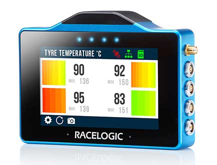
The VBOX Touch from Racelogic is the first in a new generation of highly flexible, enhanced accuracy GNSS dataloggers. The powerful hardware can be used in many types of diverse automotive tests such as acceleration, braking, speed verification, tyre temperature monitoring, lap-timing and durability, according to the company.
The VBOX Touch comes preloaded with a sophisticated performance application that covers many common use cases. Other applications can be downloaded free of charge from the Racelogic online library. Racelogic can also write custom scripts based on customer requirements.
The VBOX Touch has a daylight readable colour touchscreen, 10-Hz GNSS engine, Wi-Fi, Bluetooth, twin CAN ports, serial port, digital input and four multi-color LEDs.
Applications are written in Python script, offering greater flexibility as well as the potential for users to write code to solve their specific testing requirements. If you need a configurable, touchscreen display which can interact with two different CAN buses, log data, know the precise position and speed whilst giving clear feedback to drivers, then the VBOX Touch is for you.
A high-accuracy 2-cm RTK GPS version is available, which uses the latest dual-frequency GPS, GLONASS and Galileo signals to deliver accuracy even under difficult conditions. These new signals significantly increase the RTK resilience near trees and tall buildings, providing precise lap-timing, position triggers and trajectory maps in places where 2-cm GPS has typically not been available.
Founded in 1992, RACELOGIC are based in Buckingham, UK, and have supplied the Automotive industry with reliable and accurate GPS dataloggers for the last 18 years. In the development of the VBOX Touch we have worked closely with our end users to create a powerful tool to help them deliver results faster and more accurately on the test track or open road.
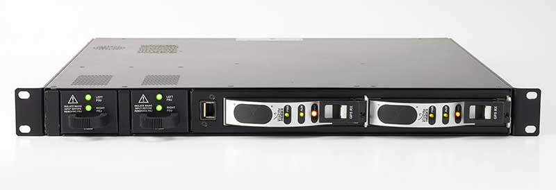
Updated GSS9000 Series takes a bow, joining range of test solutions on show
The Enhanced GSS9000 Series GNSS constellation simulator. (Photo: Tyler Gunter)
Spirent Communications will unveil its enhanced GSS9000 Series GNSS constellation simulator at ION GNSS+ 2019 in Miami, which will take place Sept. 16–20. It joins Spirent’s already impressive range of test solutions on display at the world’s largest showcase of GNSS technology, products and services.
“The industry is at a very important point,” said Spirent Marketing Director Steve Hickling. “With the volume of GNSS signals growing, more multi-constellation receivers being developed every day, and the need for greater precision increasing all the time, it’s vital that testing solutions are able to stay ahead of this reality. This is why we’re excited to demonstrate the enhanced GSS9000 Series at ION.”
The GSS9000 Series constellation simulator has been improved with enriched features and enhanced capabilities combined with an increased channel capacity. Most importantly, this greater flexibility, coherence, fidelity, performance, accuracy and reliability is maintained under all test conditions.
At ION, Spirent (booth E) will also be showing its GSS6450 — the highly portable 16-bit RF record and playback system — and the GSS7000 series multi-frequency, multi-GNSS RF simulation solution. Visitors can also learn more about Spirent’s realistic multipath and obscuration simulation tool, the new Sim3D.
Spirent’s expertise will also be demonstrated during three ION GNSS+ speaking panels: