The software-based GNSS receiver allows customers to add full GPS functionality with design flexibility and long-term upgradeability at a minimal cost, low power and no physical size to today’s cost-sensitive internet of things (IoT) applications, according to Cadence Design Systems.
To get the lowest possible power, GSN accelerated the performance of its GPS software receiver by creating several custom instructions to run on the Tensilica Fusion F1 DSP. As a result, the GPS software requires less than 110 MHz for full 12-satellite functionality.
Additionally, with this software-based solution, customers can reduce the overall processor requirements to meet less-demanding location-based use cases such as asset tracking.
“The Tensilica Fusion F1 DSP delivers outstanding performance for the implementation of our GNSS receivers, providing a low-power footprint required for IoT applications,” said Eli Ariel, CEO at GSN. “This enables customers to easily upgrade their Fusion F1 DSP-based designs to future satellite systems such as Beidou, GLONASS and Galileo via software. By leveraging several customized instructions in the Fusion F1 DSP, we were able to keep the required processor speed at the same frequency compared to DSPs with more than three times the processing power.”
“GSN’s software-based approach for GNSS allows our Fusion F1 DSP customers to precisely scale their GNSS receiver requirements to meet their applications needs,” said Gerard Andrews, group director marketing, at Cadence. “The availability of GSN’s technology on this low-power DSP platform allows our customers to add location-based services at minimal cost and power.”
The Tensilica Fusion F1 DSP offers low-energy, high-performance control and signal processing for a broad segment of IoT/wearable markets. This highly configurable architecture is specifically designed to excel at always-on processing that requires a merged controller plus DSP, ultra-low energy and a small footprint.
The DSP is efficient in running the narrowband wireless communications standards typically associated with IoT device communications, including protocols such as Bluetooth Low Energy, Thread and Zigbee using IEEE 802.15.4, Wi-Fi 802.11n and 802.11ah and GNSS.
NovAtel has integrated its high-precision positioning engine and correction services with automotive-grade multi-frequency GNSS chipsets from STMicroelectronics: specifically, the Teseo APP (Automotive Precise Positioning) and Teseo V.
The integration demonstrates possibilities for vehicle localization solutions. NovAtel is part of Hexagon’s Positioning Intelligence Division.
STMicroelectronics’s Teseo APP and Teseo V provide multi-frequency GNSS data for PPP (precise point positioning) and RTK (real-time kinematic) for accurate positioning capabilities.
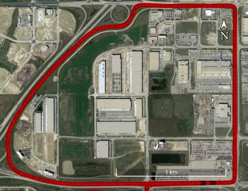
The Teseo V SBAS and Teseo V NovAtel PPP tests took place in a light urban environment. (Image: NovAtel)
NovAtel’s positioning engine combines the GNSS measurements from these chipsets with inertial measurement unit (IMU) data and Hexagon PPP correction services on the demonstration platform to deliver centimeter-level PPP positioning solutions in real time.
“Working closely with STMicroelectronics using their Teseo APP chipset allowed us to innovate and speed up the development of our assured positioning solution tailored specifically for safe positioning of autonomous vehicles,” said Jonathan Auld, VP Engineering and Safety Critical Systems from NovAtel.
NovAtel’s positioning engine architecture enables a flexible integration with different GNSS receiver chipsets, IMUs and processor environments, providing automotive manufacturers with additional flexibility when it comes to selecting components and subsystems of advanced driver assistance systems (ADAS) and autonomous driving solutions.
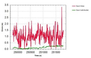
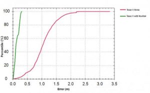
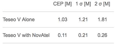
Test results: Horizontal position errors. Teseo V alone is shown in red, Teseo V + NovAtel in green. Test results: Horizontal cumulative error distribution. Teseo V alone is shown in red, Teseo V + NovAtel in green. (Chart: NovAtel)
Test results: Horizontal cumulative error distribution. Teseo V alone is shown in red, Teseo V + NovAtel in green. (Chart: NovAtel)
The positioning engine is being developed to ASIL-B standards according to ISO26262 and will include a proprietary GNSS integrity solution to ensure safe positioning within defined protection limits that are tailored to the customer’s application requirements.
“NovAtel’s choice of the automotive-quality ASIL-capable Teseo APP to integrate with their GNSS positioning engine is enabling them to develop a world-class safety-critical positioning offering to the automotive industry,” said Antonio Radaelli, Director, Infotainment Business Unit, STMicroelectronics.
NovAtel technology continues to be an integral part of the connected and autonomous car ecosystems, including academic research, industry development and real-life applications. The company’s automotive positioning solution includes automotive GNSS antenna technology, GNSS/INS positioning engine, and global correction services.
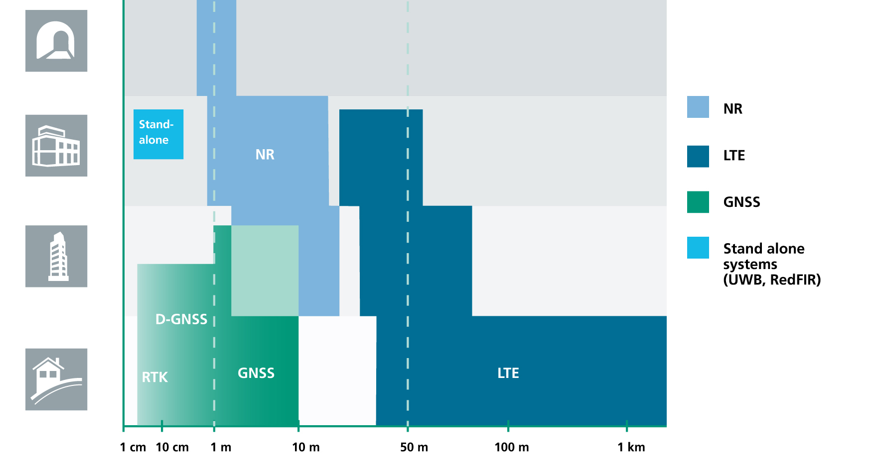
The cellular 5G standard targets latencies under 1 millisecond, data rates of up to 10 gigabits per second, extremely high network reliability and better accuracy in positioning. With location awareness becoming an essential feature in many new markets, positioning is considered as an integral part of the system design of upcoming 5G mobile networks.
The cellular industry is currently implementing Long-Term Evolution (LTE)-Advanced, which might be called “4G” mobile broadband. Simultaneously, the industry is preparing the next step, a fifth-generation (5G) system. It will process communication 10 times faster than 4G, according to experts. 5G rollout will be complete in many international metropolitan areas by 2020.
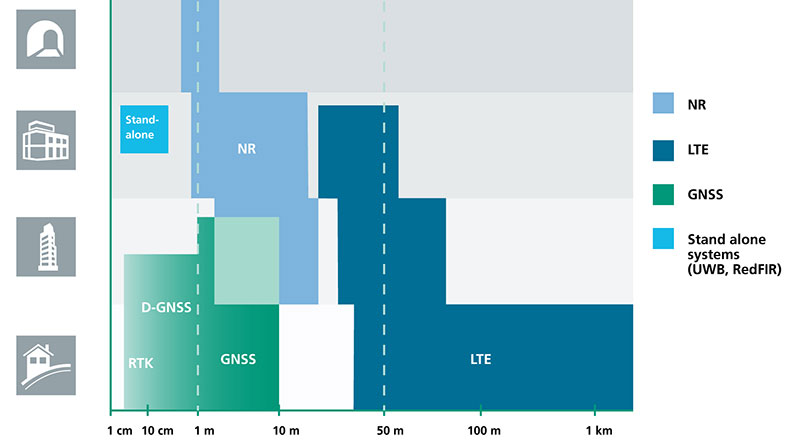
Positioning Performance for 5G NR and other technologies in different environments. (Image: Fraunhofer IIS)
Adaptive array antennas
In addition to the precise positioning it will afford, 5G shares another characteristic with GPS/GNSS: adaptive array antennas for digital beamforming (DBF). Adaptive arrays have many advantages for PNT, primarily in mitigation for multipath, jamming and spoofing.
Emerging applications of DBF in 5G involve dense networks of picocells, small cellular base stations that typically cover a small indoor area. Picocells extend coverage where outdoor signals do not reach well, and add network capacity in areas with very dense phone usage. 5G architectures will use adaptive array technology to achieve high data rates, spectrum reuse and communications robustness.
The implications for PNT are that 5G will require improved (relative) PNT to operate effectively, and picocells will be a source of PNT information in constrained environments.
5G involves massive directional communications via multiple-input, multiple-output (MIMO), enabling high-bandwidth communications in fading (multipath) channels by using multiple antenna inputs to adapt to channels. It can do this without knowledge of user location, but it adds to the processing complexity. The directional capability can enable multiple users to be serviced in a picocell at different frequencies, while permitting spectrum re-use by nearby picocells through narrow beamwidth and the limited range of millimeter-wave (mmWave) frequencies.
The PNT implications of 5G architectures, according to Gary McGraw of Rockwell Collins, are that 5G picocells will be synergistic with PNT in challenged environments — naturally, indoor and dense urban. They will necessitate development of distributed, networked PNT processing and infrastructure.
Fraunhofer
The 5G positioning framework will integrate a multitude of sensors into a hybrid positioning scheme, according to the Fraunhofer Institute for Integrated Circuits (IIS) in Germany. Fraunhofer IIS is currently prototyping low-latency and high-precision positioning systems for legacy LTE and future 5G New Radio (5G NR).
5G NR enables positioning by providing high bandwidths for precise timing, new frequency bands at mmWave, massive MIMO for accurate angle-of-arrival estimation and new architectural options that support positioning. Improved accuracy, robustness and latency can be achieved, according to the institute.
5G provides fast and reliable access to moving objects to achieve time-critical process control and optimization in industrial environments. Increased contextual awareness of goods, parts, machines and workers will enable new interaction and collaboration, the institute said.
Assisting safer autonomous driving, STMicroelectronics has introduced a multi-frequency GNSS receiver chipset suitable for safety-critical automotive applications and high-accuracy positioning at the decimeter and centimeter-level for precise point positioning (PPP) and real-time kinematic (RTK) applications.
Traditional in-car navigation systems help drivers reach their destinations using receivers and commercial satellite services that allow positioning accurate to within a few meters.
With increasing use of autonomous systems such as lane-departure warning (LDW), adaptive cruise control (ACC), valet parking and auto-pilot, greater accuracy is needed to ensure safety and reliability, in combination with proximity sensors such as cameras, radar, lidar and others, to monitor the driving environment automatically. Fully self-driving vehicles of the future will also demand high-accuracy positioning.
By tracking satellites of all GNSS constellations simultaneously on at least two of the frequencies used by each system, ST’s automotive-quality Teseo APP (automotive precise positioning) receiver provides high-quality raw GNSS data for PPP and RTK algorithms, which allows accurate positioning and rapid convergence time worldwide.
In addition to its high accuracy, the receiver monitors the integrity of the satellite data to alert the system if accuracy is degraded for any reason. This permits Tier-1 manufacturers to certify safety-critical systems in accordance with the automotive industry functional-safety standard, ISO 26262, up to the highest Automotive Safety Integrity Level (ASIL).
Teseo APP also integrates a secure microcontroller for secure system boot and data-output authentication to keep sensitive data safe from attack.
Launched alongside Teseo APP, ST’s Teseo V chip provides equivalent multi-frequency precise positioning in a simplified device for non-safety-critical applications where integrity assurance is not required.
“High-accuracy satellite positioning makes autonomous driving safer, smoother, and more reliable,” said Antonio Radaelli, director, Infotainment Business Unit, STMicroelectronics. “Our newest Teseo APP GNSS chip combines extreme accuracy and precision with industry-unique integrity assurance for use in safety-critical applications.”
Teseo APP eliminates errors by tracking all available GNSS signals in multiple frequency bands, such as the GPS and GLONASS, Galielo, BeiDou, QZSS, and IRNSS L1, L2, and L5 frequency bands, and the Galileo E6 signal that contains PPP correction data to allow worldwide decimeter-level accuracy.
Other techniques for enhancing accuracy have included differential systems reliant on a combination of ground base-station signals as well as satellite signals, or techniques such as RTK, which generally require a denser reference station network.
The new Teseo chips make high-accuracy affordable for autonomous driving through a combination of tracking up to three constellations simultaneously over two frequency domains. These multi-frequency combinations bring reliable GNSS ionospheric and multipath modeling in most environments, allowing accurate positioning with faster convergence time for automotive applications, where timing is critical.
ST is now supplying product samples to lead customers who are developing autonomous-driving systems expected to appear first in high-end vehicles launched in 2020/2021.
Visitors to Mobile World Congress 2018 in Barcelona, Feb. 26 to March 1, can see Teseo APP at the ST booth, Hall 7, Stand 7A61.
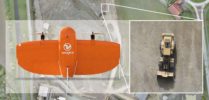
Belgian GNSS receiver manufacturer Septentrio was selected by Swiss drone manufacturer Wingtra to supply GNSS OEM receiver boards and PPK processing software for the recently-launched WingtraOne PPK drone.
The combination of vertical take-off and landing (VTOL) technology and a high-spec post-process kinematics (PPK) brings wide-area coverage at ultra-high precision.
Following a flight, the GNSS data of the WingtraOne is processed offline using Septentrio’s PPK software. This combines the drone data with correction data from a nearby reference receiver to get accurate cm-level geolocations for every photograph.
The on-board high-resolution Sony RX1RII camera, AsteRx-m2 UAS receiver board combined with Septentrio’s PPK library, and Pix4D photogrammetry processing software are together able to produce ground precisions of 1.3 centimeter (cm) horizontal and 2.3 cm vertical.
Image: Wingtra
“With the WingtraOne PPK, we can offer a world first in drone photogrammetry — wide coverage at ultra-high precision,” said Armin Ambühl, CTO of Wingtra. “In a single one-hour flight, the WingtraOne can cover 130 ha (320 acres) delivering mapping with GSDs [ground sample distance] below 1 cm/pixel with absolute accuracy down to 1.27 cm.”
He continued, “WingtraOne’s advantage is twofold: it combines VTOL with the latest PPK technology from Septentrio. With VTOL we can offer the best of both worlds: multirotors and fixed-wings. Vertical take-off and landing means hands-free operation and a smoother ride for the on-board camera payload. Secondly, efficient flying in fixed-wing mode means far greater coverage than any comparable multirotor.”
“We are proud and excited to be part of this innovative project with Wingtra pushing the boundaries of aerial photogrammetry,” said Gustavo Lopez, product manager at Septentrio. “The WingtraOne incorporates our AsteRx-m2 UAS OEM board and, photogrammetry applications requiring high-precision, low-latency positioning are what it does best. The board is specifically designed for quick and easy integration and, with Septentrio’s world-first, multi-frequency PPK, cm-level precision can now reach the parts dual-constellation solutions feared to tread.”
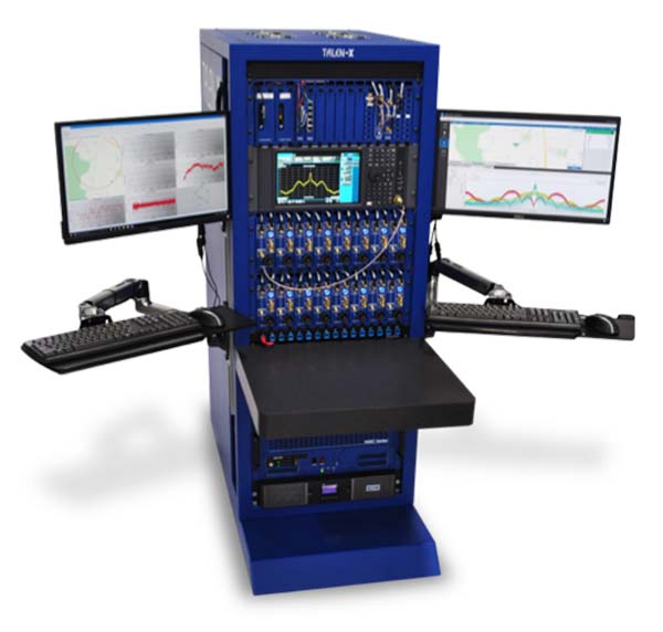
In mid-2017, Talen-X and Skydel engineers began to conceptualize a GNSS simulation system emanating from their BroadSim platform for the purpose of fortifying anechoic chambers.
Over the next six months, Talen-X and Skydel designed, built, tested and delivered an anechoic chamber simulator capable of simultaneously generating multi-GNSS jamming and spoofing signals.
BroadSim Anechoic can be used to support a wide variety of operational tests.
“Our new Anechoic Chamber solution will radically change the way in which mission critical platforms and systems are tested because we are enabling our customers to create real-world threats,” said Talen-X Chief Technology Officer Tim Erbes said. “Not only will BroadSim Anechoic be able to emulate real-world threat scenarios, it will be easier than ever before to create and simulate these environments.”
BroadSim Anechoic is used to test GNSS spoofing and jamming in an anechoic chamber. The BroadSim Controller is at the heart of the system running Skydel’s SDX software suite. Using SDX, users can create advanced scenarios that include both jamming and spoofing signals.
The 16 software-defined radios (SDRs) each with dual transmit ports (32 total outputs) can be configured to output GNSS or jamming signals, giving users flexibility to run test after test. The transmit chains include the hardware to power 16 dual-frequency antennas. The included GNSS receivers allow users to monitor the environment inside the chamber, providing confidence that tests are running correctly.
The BroadSim Anechoic can also be used in controlled radiation pattern antenna (CRPA) testing. Many ground-, airborne- and water-based platforms are transitioning to using CRPAs because of their added jamming resiliency and significant tracking advantages in degraded environments.
Validation and real-world testing is critical to understanding and characterizing the mitigation these antennas can add in highly degraded areas. By using BroadSim Anechoic, users have the ability to create representative jammers with real-world characteristics (modulations, frequencies, angles, power levels, etc).
“Skydel developed an innovative approach for time offset calibration between multiple transmitting antenna using a COTS Software-Defined Radio (SDR),” said Skydel Solutions Chief Technology Officer, Iurie Ilie. “This approach allows for very precise measurements and adjustments (better than 100ps) to be done automatically before simulation start. At the same time, transmitting signal power is automatically adjusted to keep the power offset at receiving antenna better than 0.1dB.”
BroadSim Anechoic takes advantage of state-of-the-art software defined radios (SDR) for RF up-converting while signal IQ generation is done using high performance commercial-off-the-shelf (COTS) graphics-processing units (GPU). The ability to generate the IQ data in software (using the GPU) as opposed to hardware (FPGA) significantly reduces the cost while maximizing capability, value, and time to market.
BroadSim Anechoic has the capability of powering up to 16-dual frequency antennas requiring 32 RF transmit outputs. The architecture used for this system required the ability to receive signals in a manner such that precise processing could be done on the receive signal.
The SDR selected for this application has one receiver channel for every transmit channel giving BroadSim Anechoic 32 RF receive ports. Innovative software techniques have been developed enabling the accurate time and power calibration for each antenna transmit chain using the SDR receive ports.
OriginGPS has chosen Gemalto’s Cinterion LTE-M wireless module to build its latest miniature OriginIoT system. Gemalto, a digital security company, designed the module for low-power applications requiring high security.
OriginIoT systems are generic cellular internet of things (IoT) systems that simplify IoT product development and slash development resources.
The systems include communication hardware, a GNSS module, embedded software and a novel interface to OriginIoT add-ons that accommodate multiple sensors and other peripheral devices.
OriginGPS signal-to-noise technology is leveraged to deliver superior GNSS and cellular matching, facilitating excellent performance in noisy environments, while the OriginSmart software enables cloud-based programming, relieving developers from writing embedded code.
The OriginIoT LTE-M system (ORG2101) has a 15 percent smaller footprint than the previous 2G and 3G models, and will be pre-certified with selected operators.
The low-power, wide-area Cinterion LTE-M module supports more than 10 frequency bands from a single hardware device, eliminating the need for multiple variants. The module protocols can run on the same hardware, thus providing a future-proof path for additional OriginIoT models.
“To save resources and stay competitive, such easy to develop low power solutions are essential for today’s IoT products,” said Andreas Haegele, senior vice president of IoT products for Gemalto. “We are glad to see that OriginGPS is expanding the market by offering accessible, affordable IoT products that are backed by Gemalto reliability and high quality,”
“We designed the OriginIoT LTE-M system to address market pains, and so our new offering includes low power consumption, superb GNSS/cellular matching, interfaces to multiple connectors, and software to enable developing from the convenience of the cloud,” said Robert van Tilburg, VP Global Sales and Business Development of OriginGPS. “These features serve to simplify and shorten IoT projects. Gemalto’s Cinterion IoT module enables OriginGPS products to retain their world’s smallest footprint, while enhancing their security and extending end-product life.”
OriginGPS will be showcasing its GNSS modules and OriginIoT systems at Embedded World, Feb. 27 – Mar. 1, in Hall 3, Booth 121.
Fugro has won a long-term contract to provide GNSS-based rig positioning services to Statoil Petroleum AS.
The contract includes positioning of all the Statoil operated rigs on the Norwegian continental shelf and associated Statoil vessels.
Fugro’s specialized satellite positioning systems, utilizing all available navigation satellites (GPS, GLONASS, Beidou and Galileo), will be permanently installed on the Statoil-operated rigs and vessels.
The robustness and accuracy (better than 3 centimeters) of these satellite systems, in conjunction with Fugro’s latest navigation software and technology developments, will ensure the best possible service for Statoil, Fugro said.
Developments in technology will bring two significant benefits to Statoil: by remotely configuring the offshore systems from Fugro’s onshore bases, mobilization time will be reduced and fast-track operations will be enabled.
Fugro will providing GNSS positioning services to Statoil Petroleum’s oil rigs and vessels. (Photo: Fugro)
Berit Sagatun, commercial manager for Fugro, cited the company’s track record in the delivery of innovative rig positioning systems.
“For decades Fugro has been at the forefront of the rig positioning market in Norway,” Sagatun said. “Our knowledgeable and responsive project management team, combined with our highly skilled and experienced offshore personnel, ensures safe and efficient operations for Statoil.”
Red Bull Air Race has selected the VectorNav VN-300 dual-antenna GNSS-aided inertial navigation system (INS) as its primary source of aircraft telemetry data for Master Class raceplanes participating in the Red Bull Air Race World Championship.
Weighing less than 30 grams, the VectorNav VN-300 is a tiny dual-antenna GNSS-aided INS. It is used in applications ranging from autonomous vehicles to antenna pointing for satellite communication and aerial surveillance applications.
The inaugural event of the 2018 season in Abu Dhabi saw the VN-300, manufactured by VectorNav Technologies, used for the first time in all 14 aircraft to provide real-time telemetry data used for judging, in-race simulation and virtual reality applications.
Created in 2003, the world championship has held more than 80 races around the globe. The motorsport competition combines speed, precision and skill.
U.S. pilot Michael Goulian performs during the finals at the first round of the Red Bull Air Race World Championship in Abu Dhabi on Feb. 3.(Photo: Andreas Langreiter, Red Bull Content Pool)
Using the fastest, most agile, lightweight racing planes, pilots hit speeds of 370 km/h while enduring forces of up to 10 G as they navigate a low-level slalom track marked by 25-meter-high, air-filled pylons. Pilots incur time penalties for hitting pylons, incorrectly passing through air gates or only exceeding 10 G for more than 0.6 seconds, among others.
Being an individual sport, spectators need a reference to see the difference between the pilots’ lines and speed through the racetrack. Red Bull Air Race Live TV uses an augmented reality (AR) solution known as the Ghost Plane to display the trajectory of the pilots’ runs for real-time comparison in the head-to-head rounds and the Final 4 that decides the winner of the race by time.
The Ghost Plane is driven by the position, velocity and attitude data gathered during flight from the onboard INS.
Critical to the success of the Ghost Plane is the accuracy of the telemetry data, which, given the high dynamics experienced during flight, is extremely difficult to obtain.
For example, as a plane races through a chicane and into a vertical turn maneuver, GPS signals are lost and the INS needs to rely solely on the inertial sensors to accurately estimate the position and velocity until GPS is fixed again in level flight.
The VectorNav VN-300. (Photo: VectorNav)
“We evaluated several different inertial navigation systems and struggled to find one that was able to perform in our dynamics,” said Alvaro Navas, sport technical manager for the Red Bull Air Race. “VectorNav’s VN-300 was the only product able to deliver the attitude, position and velocity data accuracy we require, and it did this out of the box, no customization was required. The sensor is really amazing.”
“We are really excited to be working with Red Bull Air Race,” said Gordon Hain, VectorNav product manager. “Not only are we able to provide accurate data for the race judges and spectators, but we are also able to provide valuable information to pilots and tacticians. With the VectorNav data in hand, they are able to compare actual flight trajectories with their simulations to find areas for improvement. We are looking forward to continued work with Red Bull Air Race in the 2018 season and beyond.”
This comment piqued my ears when heard over the coffee-break table at ION’s International Technical Meeting last month: “There is a great deal of mutual ignorance between the 5G and PNT communities. I think that the 5G people are pretty naive about PNT and the PNT community is missing an opportunity.”
So when news releases leading up to next week’s Mobile World Congress — several of them mentioning 5G in rosy terms, “catalyst for a better future” typical among these — started flooding my inbox this morning, it seemed an opportune time to investigate. Pardon my top-slice view; I’m not well-versed enough in the technology to discourse knowledgeably, but here’s quick round-up of salient points related to positioning in the fast-oncoming Next Step in cellular communications.
Regular contributing editor for Professional OEM and UAV Tony Murfin will return to this space next month, with a column previewing the massive AUVSI Xponential show in Denver, April 30–May 3. He’ll be there, too, covering the event!
The cellular 5G standard has been designed to target latencies under one millisecond, data rates of up to ten gigabits per second, extremely high network reliability, and better accuracy in positioning. With location awareness becoming an essential feature of many new markets, positioning is consequently considered as an integral part of the system design of upcoming 5G mobile networks.
Its feet firmly planted in both the present and the future, the cellular industry is currently in the midst of implementation of Long Term Evolution (LTE)-Advanced, an evolution of what might be called plain old LTE, and a “true 4G” mobile broadband. Simultaneously, the industry is preparing the next step, as “there is a vastly increased need for a new mobile communications system with even further enhanced capabilities, namely a fifth generation (5G) system.” 5G will process communication 10 times faster than 4G, according to experts. That’s enough to download a 3D movie in 30 seconds. It would take six minutes on 4G.
Pyeongchang
Alert techie viewers of the present ongoing Olympics in South Korea may have noted 5G in action there, in demos of such things as live-streaming virtual reality of bobsled and luge runs, putting the viewer in the breathtaking driver’s seat, and a test drive earlier this month from Seoul to Pyeongchang, a journey of several hours, without any human intervention whatsoever at the car’s controls. The demonstrations in Pyeongchang are laying down a backbone for what will be on show at the Tokyo Games in 2020, when 5G roll-out will be complete in many major metro areas.
As trumpets sound the fanfare for next week’s Mobile World Congress in Barcelona, AT&T announced it will first roll out 5G to three locations: Dallas, Texas; Waco, Texas; and Atlanta, Georgia. The plans introduce the service to about a dozen U.S. markets by late this year. Qualcomm meanwhile is offering insight into its 5G chips.
What has all this got to do with GNSS? Well, aside from the aforementioned precise positioning via cellular to be afforded by 5G, the two technologies share one prominent technique: adaptive array antennas for digital beam-forming. Here I am indebted to Gary McGraw of Rockwell Collins for a primer on the subject, which he presented at the International Technical Symposium on Navigation and Timing (ITSNT) in November 2016.
Adaptive array technologies have many advantages for PNT: primarily, in mitigation for multipath and for jamming and spoofing mitigation. Adaptive antenna arrays with digital beam-forming (DBF) are becoming increasingly important for PNT in challenging signal environments. DBF combines multiple antenna inputs to generate gain in arrival direction of the desired satellite signal and to create spatial nulls in direction of jamming.
Emerging applications of DBF in 5G involve dense networks of picocells, small cellular base stations typically covering a small indoor area. Picocells extend coverage where outdoor signals do not reach well, and add network capacity in areas with very dense phone usage. In this context, 5G cellular architectures will use adaptive array technology to achieve high data rates, spectrum reuse and communications robustness.
The implications for PNT are that 5G system architectures will require improved (relative) PNT to operate effectively, and these 5G picocells will be a source of PNT information in constrained environments.
5G involves massive directional communications via multiple-input multiple-output (MIMO), enabling high-bandwidth communications in fading (multipath) channels by using multiple antenna inputs to adapt to channel. It can do this without knowledge of user location, but it adds to the processing complexity. The directional capability can enable multiple users to be serviced in a picocell at different frequencies, while permitting spectrum re-use by nearby picocells through narrow beam-width and the limited range of millimeter-wave frequencies.
The PNT implications of 5G architectures, according to Gary McGraw of Rockwell, are, principally, that efficient operation of directional links will require some level of knowledge of user location with regard to picocells. Picocells will need to have the ability to do direction-of-arrival positioning and ranging in order to maintain connectivity with user nodes. This can be exploited by the user node for positioning and location-based services, particularly for indoor and dense urban environments. Meanwhile, the proliferation of adaptive array technology will drive down costs for other applications. Further, millimeter-wave transmit/receive modules will become commodity items, analogous to what cell phones have done for GPS chips.
McGraw’s Summary
5G picocells will be synergistic with PNT in challenged environments — naturally, indoor and dense urban. They will necessitate development of distributed, networked PNT processing and infrastructure. Availability of adaptive array technology will increase with deployment of 5G, and costs can be expected to drop dramatically. In addition to GNSS, adaptive array technologies can be employed to support short-range, relative PNT applications such as vehicle-to-vehicle communications and relative positioning.
Driving the Bus
The key driver for all this is that customers, the global We, expect the same quality of experience from Internet applications anytime, anywhere, and through any means of connectivity. The rapid proliferation of smartphones and other mobile devices that support a wide range of applications and services mean that image transfer and video-streaming, as well as more cloud-based services, such as cloud speech services, have become the new norm. Their requirement for massively more data than, say, simple texting is conveniently hidden from or forgotten by users. We want it. We want it now.
From a DOCOMO 5G White Paper: 5G Radio Access: Requirements, Concept and Technologies. NTT DOCOMO, INC., July 2014. At https://www.nttdocomo.co.jp/english/binary/pdf/corporate/technology/whitepaper_5g/DOCOMO_5G_White_Paper.pdf.
Tomorrow, or perhaps the next day, everything will be connected by wireless to enable monitoring and collection of information and control of devices. Thus, remote monitoring and real-time control of nearly all electronic devices in machine-to-machine (M2M) services and Internet of things (IoT): connected cars, connected homes, moving robots and sensors. Such services will become more extensive and enriched through richer content delivered in real-time. Get set for the tactile Internet, augmented reality, and other brave new wonders.
Fraunhofer Enters the Fray
The 5G positioning framework will thereby integrate a multitude of sensors based on both, cellular signals and 3GPP independent techniques, into a hybrid positioning scheme, according to the Fraunhofer Institute for Integrated Circuits (IIS) in Germany. Fraunhofer IIS is currently prototyping low-latency and high-precision positioning systems for legacy LTE and future 5G New Radio (NR). Two selected industrial IoT live demonstrations can be seen at next week’s Mobile World Congress 2018.
Respective positioning performance for 5G NR and other technologies in different environments. (Image: Fraunhofer IIS)
5G NR enables positioning performance by providing high bandwidths for precise timing, new frequency bands at mm-wave, massive MIMO for accurate angle-of-arrival estimation and new architectural options that support positioning. Improved levels of accuracy, robustness and latency, not possible today, can soon be achieved, according to Institute. 5G provides fast and reliable access to moving objects, to achieve time-critical process control and optimization in industrial environments not possible with today’s cellular technology. As requirements vary according to the specific use cases, 5G NR will provide a flexible air interface allowing for scalable bandwidths, data rates, latencies, and positioning accuracy levels.
High-Precision Positioning
With location awareness becoming an essential feature of many new markets, positioning is an integral part of the system design of 5G mobile networks. Increased contextual awareness of goods, parts, machines and workers will enable new interaction and collaboration.
High-precision positioning, in the view of Fraunhofer IIS. (Image: Fraunhofer IIS)
Fraunhofer IIS is working on novel approaches for sub-meter accuracy to enable tracking of mobile devices in indoor and urban areas where GNSS is not sufficiently accurate nor available. Its 5G positioning framework integrate several sensors. The key benefits of 5G in this regard are high accuracy, reliability, mobility and coverage; low latency and low power; and scalability.
The Institute offers the facilities of its Test and Application Center L.I.N.K. in Nuremberg, Germany. The test center includes a 3D positioning system capable, according to the organization, of reproducing, simulating and emulating all kinds of possible environments, using every common communication and positioning system commercially available.
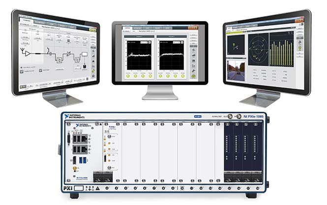
Averna is offering a wideband RF record and playback platform. The RP-6500 records and plays back up to 500 MHz of RF spectrum — from 9 kHz to 6 GHz — to test multi-constellation GNSS applications, the company said. The system can also capture other signals such as Wi-Fi, V2x, spectrum sharing and cellular applications.
The robust system fits into a car trunk for driving/recording applications, and syncs with both a GPS and Averna’s DriveView software for synchronized location and video capture that is time-aligned.
Preloaded with RF Studio, a state-of-the-art workflow tool, the RP-6500 Series lets users quickly set up recordings, add contextual data, visualize weak signals and analyze the collected RF environments to validate and fine-tune designs and products.
“The RP-6500 is a complete RF Record and Playback platform–it’s been designed and built from the ground up to be all-in-one,” said Alex Pelland, product line manager at Averna. “The hardware ticks all the boxes for serious users, and we’ve bundled it with RF Studio, so that all users can achieve simple configuration, file management, and visualization as well.”
Key Features and Benefits
Easy-to-use RF Studio user interface
500 MHz wide instantaneous bandwidth
Covers most common wireless protocols from 9 kHz to 6 GHz
High dynamic range (14 bits, ~ 86 dB)
Form factor allows rack mounting or car trunk portability
Time-synchronized capture of RF, signals, and messages
Helix Technologies Ltd. has been awarded a significant contract by the European Space Agency (ESA) to develop its next-generation GNSS antenna — a multi-frequency antenna optimized for the advanced Galileo E1 Alt-BOC and wide-band E5 Alt-BOC waveforms for use in driverless cars.
The antenna, to be developed under the ESA’s Navigation Innovation and Support Programme (NAVISP), will provide enhanced performance due to its dielectric, multi-filar construction. It will also be optimized to take maximum advantage of the Galileo E5 Alt-BOC waveform, which enables significantly improved measurement accuracy, precision and multipath suppression over conventional GNSS signals.
Learn more about the Helix Technologies antenna in our February issue article here.
“In order to achieve the 10-centimeter accuracy that is required for autonomous vehicle lane-level positioning within challenging urban multi-path propagation conditions, there is a need both for a significant improvement in current GNSS antenna performance and to fully exploit the advanced Alt-BOC waveforms transmitted by Galileo,” said John Yates, managing director of Helix Technologies.
The GNSS antenna, which will also be capable of optimized operation with the GPS L1 and L5 M BOC signals, is aimed at the automotive and consumer markets, and the company is targeting the third quarter of this year for the manufacture of prototypes.
Independent testing and evaluation of the vehicle-mounted antenna performance will be conducted in the challenging multipath environments of the high-rise financial districts of the cities of London and Shanghai.
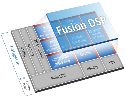 To get the lowest possible power, GSN accelerated the performance of its GPS software receiver by creating several custom instructions to run on the Tensilica Fusion F1 DSP. As a result, the GPS software requires less than 110 MHz for full 12-satellite functionality.