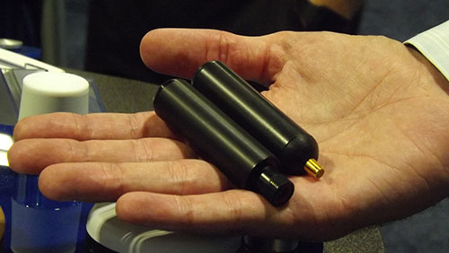
PCTEL’s GPS/GLONASS high-performance asset tracking and synchronization helix antennas are now available commercially. The antennas capture the frequencies needed for GPS, Galileo and GLONASS satellite reception. This cross-compatibility allows global OEMs to use one standard platform to serve both European and U.S. markets.
PCTEL will display its new IP67-rated GEO-GNSS antennas and other mobile and GPS antennas Sept. 16-17 at ION GNSS+, Booth #416.
PCTEL uses its proprietary filtering design to allow wideband coverage while achieving superior out-of-band rejection, the company said. The small form-factor helix antennas will withstand harsh environments.
“Customers expect PCTEL to solve challenging problems,” said Rishi Bharadwaj, PCTEL’s vice president and general manager, Connected Solutions. “We designed PCTEL’s GEO-GNSS series for complex asset tracking and network timing applications.”
For more information about PCTEL’s GEO-GNSS helix antennas, visit the PCTEL website.
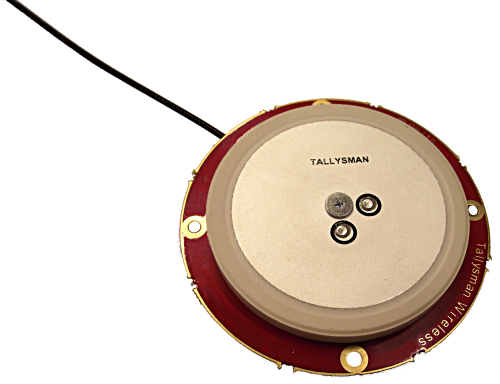
Tallysman, a manufacturer of economical high-performance GNSS antennas, has announced a new series of L1 band Accutenna wideband antennas for OEM applications. The antennas are offered in three formats for reception of GPS; GPS + GLONASS; or Galileo + GPS + GLONASS + BeiDou.
Each antenna type features Tallysman’s Accutenna technology, which provides high rejection of multi-path signals, with low axial ratios, and tight Phase Center Variations (PCV). Each is available with a brickwall pre-filter option to protect against saturation by high level sub-harmonic and L-Band signals.
Here are what each antenna in the new line covers:
The TW2106 is designed to receive GPS L1. TW2108 is the brick-wall pre-filtered version.
The TW2406 is designed to receive GPS + GLONASS. TW2408 is the brick-wall pre-filter version.
The TW2706 is designed to receive all of Galileo, BeiDou, GPS + GLONASS. TW2708 is the brick-wall pre-filter version.
The antenna PCBs are each 56 mm in diameter with four plated holes for secure mounting. They are available with a variety of connectors and custom cable lengths. The antennas can be custom tuned to ensure optimal performance within customers’ enclosures. All of them are REACH and ROHS compliant.
INTERGEO Announcement
At INTERGEO in Stuttgart, Tallysman will be announcing the availability of patented new GNSS antenna technology that it said is proving to:
Produce the lowest axial ratios from horizon to horizon through all azimuths and across all GNSS frequencies
Produce sub-millimetre Phase Centre Variation (PCV) through all elevations, all azimuths, and across all GNSS frequencies
Be lighter weight, smaller size, and more economical than other reference and geodetic antennas
Have the unique feature of having room within the antenna base to house customers’ circuitry.
Tallysman’s booth at INTERGEO will be in Hall E8, Booth 038. Follow GPS World on Twitter for the latest news from INTERGEO.
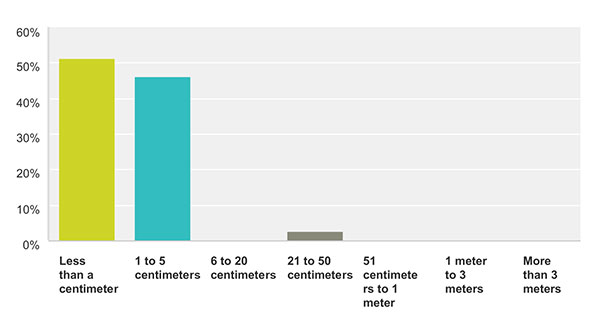
How accurate is good enough for the majority of your market sector? This chart show the answers from those who identified themselves as members of the survey and high-precision community. For more results from this and other sectors, see the 2015 State of the GNSS Industry Report.
Memory fails as to who first said “Accuracy is addictive.” Or perhaps it’s my knowledge base that is deficient. At any rate, I’ll gladly publish documented evidence from anyone who can show the earliest — print or audio — expression of that dictum. It continues to hold as true for this industry as Moore’s Law does for computer technology as a whole.
We have seen the gradual tightening of accuracy requirements across all sectors of the positioning, navigation and timing (PNT) community with each successive iteration of our State of the GNSS Industry Survey, now in its fourth year. This is the first time we have seen it cross the 1-centimeter line. Not in capability; sub-centimeter capability has been available for some time. But now that level of performance is the minimum acceptable “good enough” for more respondents in the survey and high-precision sector than any lesser degree of accuracy; in fact, greater than all other ranges combined. These addicts form the new majority. Their preferences and their behaviors will rule our world.
Other sectors will presumably answer likewise in coming years, following the trail blazed by the high-precision pioneers.
We have crossed the Rubicon. Unlike other obsessive behaviors, there is no going back in our case. This path is a one-way road to — well, not to the various hells entailed by other addictions — but to the promised land of always-on, always-true, near-perfect provision of positioning.
Let’s not kid ourselves, however. The perfect world does not exist. The closer we get to millimetric accuracy, the more obstacles we find in our way. Indoor continuity aka ubiquity, jamming, spoofing, hacking, budget cutbacks, slides to the right — this list will surely grow.
The more acute our addiction, the lower our tolerance for less-than-total fulfillment.
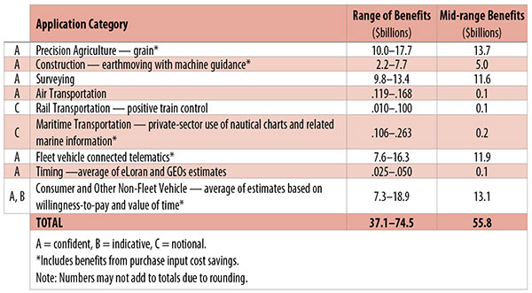
Table 1. Preliminary 2013 U.S. GPS economic benefit estimates. (Chart: GPS World, based on data from author)
This article is based on a presentation to the National Space-Based Positioning, Navigation and Timing Advisory Board in June 2015. The study reported on at the meeting was requested by the National Executive Committee for Space-Based Positioning, Navigation and Timing. It demonstrates the widespread use and importance of GPS to the U.S., with estimated benefits in 2013 of about $56 billion, or 0.3% of GDP for a subset of applications. The study is the first part of an effort that is expected to refine and extend this analysis.
By Irv Leveson
Critical to many civilian applications and innovations, GPS brings great economic benefits. These benefits have grown rapidly with the integration of GPS with other technologies and its wider and deeper infusion into applications. New GPS signals and other improvements in the system will further expand and enhance use. The unmistakable conclusion: GPS is everywhere.
Benefits of GPS to the U.S. will increase with the availability of other GNSS systems, even though GPS will constitute a smaller share of global GNSS benefits. The U.S. will continue to provide leadership, standards and innovation in technology and applications with positive domestic feedback.
GPS and other GNSS and enhancements raise productivity; reduce and avoid costs; save time; enable improved and new production processes, products and markets; increase health and well-being; reduce injury and loss of life; improve the environment; and increase security.
The National Executive Committee for Space-Based Positioning, Navigation and Timing (PNT), which is responsible for maintaining U.S. leadership in GNSS, commissioned a study to assign a quantitative value to the broad economic uses of GPS. The purpose is to inform the public, federal decision makers and critical infrastructure owners/operators on the importance of GPS and the need to protect it from disruption. Assessing the economic implications of actions such as preventing or disallowing interference, spectrum reallocation, developing supplementary or backup systems and/or toughening receivers can be informed by value estimates and the data used to derive them. In addition, economic values can contribute to planning for GPS modernization and analysis of budgets. Baseline estimates facilitate comparisons with future developments. GPS benefit estimates will be “ballpark” no matter how sophisticated the methodology because of limits to the availability of information, but in many cases, knowing orders of magnitude is essential in choosing courses of action.
Widespread, Pervasive Impact. The technological environment is one of rapid changes in information and materials technology and integration of technologies at levels ranging from systems on a chip to large-scale systems. GPS is increasingly integrated with other technologies and systems that build on each other to achieve greater outcomes.
The U.S. Department of Homeland Security counts GPS as an enabling technology because of its crucial role in 14 of the 16 industries that are classified as part of the nation’s critical infrastructure. It is useful to view GPS’ role as being especially important in “enabling the enablers,” industries that particularly support the rest of the economy and are at the forefront of economic growth. The most notable of these are transportation, communications, power and financial services.
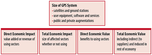
Economic Value versus Impact
Economic value is the addition to the value of the economy from the provision of a good or service, or the introduction of a technology. Benefits are measured relative to what would have been expected if there were no GPS. Direct economic value is the increase in value in using sectors. Total economic value includes increases in value to suppliers and value induced in the rest of the economy.
Direct economic impact, on the other hand, refers to measures of the importance of sectors that are using GPS. Total economic impact is the importance of sectors affected by GPS, whether they are using it or not. Total economic impact of GPS is virtually the size of the whole economy, so it is not very meaningful.
Direct economic impact is measured by value added of using sectors when the purpose is to avoid duplication among sectors that buy from and sell to each other. It may be measured by revenue for a single sector when adding sectors is not involved, so there is no need to avoid duplication.
The distinction between economic value and economic impact is critical. Even if economic impact is measured by value added rather than revenue, the value is not the net addition to the economy from the use of the product or technology. It is only the size of the using sector. See Figure 1.
Figure 1. Measuring GPS economic value and economic impact. (Chart: author)
The GSA Study
The most comprehensive estimates of global GNSS market size come from the European GNSS Agency (GSA), which has released four market reports from 2010 through 2015. The data are measures of economic impact and not economic value. The reports are of great interest because of their comprehensive global look at the sizes of markets and inclusion of forecasts. In contrast, the emphasis in this part of the present study is on current economic value, with U.S. benefits assessed for GPS.
One reason for interest in the GSA reports is that market information and projections often are proprietary and there can be great inconsistency across market research studies. GSA makes use of many confidential studies without revealing which sources contributed to each estimate. It apparently has been allowed to incorporate proprietary information from a number of market research firms since the data is subsumed in GSA’s own estimates and/or presented in graphs for which underlying numbers are not provided — and from which it is often difficult to even roughly extract them.
The 2015 report stated the methodology as: “The underlying forecasting model uses advanced forecasting techniques applied to a wide range of input data, assumptions and scenarios…Where possible, historical values are anchored to actual data.” Results were checked against opinions of market segment experts and market research reports. However, these analyses are not provided in the reports and have not been made available.
A distinction is made between the core market which covers the value of components that provide GNSS functionality in devices and enabled markets which “represent the services and devices enabled by GNSS.” The 2015 report provides global data on both core and enabled market and goes into much more detail on core markets for application sectors. In addition to providing sector information that did not appear previously, the 2015 report presents data on the extent to which each combination of the GNSS constellations was supported by receivers or chipsets offered by suppliers. Additional information on enabled sectors is in earlier reports.
GSA found in its 2015 market report that:
3.6 billion GNSS devices were in use globally in 2014, of which 3.08 billion were smartphones and .26 billion were for road.
North America had about 450 million devices installed (about 80% U.S.).
North America had 1.4 devices per capita in 2014.
North American shipments were 250–300 million in 2013.
Global core revenue was estimated at roughly €62 billion and enabled revenue at €227 billion in 2014. As noted, core revenue includes GNSS device components, software and services, while enabled revenue refers to applications.
Location-based services (LBS) was projected to account for 53.2% of 2013–2023 core revenue growth, and road for 38%.
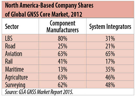
North American-based companies had sizeable shares of the global GNSS core market in 2012, particularly among component manufacturers. (See Table 2). Their market share among system integrators was highest in aviation.
North American-based companies had a 44% market share of value-added services revenue in 2012.
Table 2. North America-based company shares of Global GNSS core market, 2012. (Chart: author)
Markets and Applications
The pervasiveness of GPS-enabled applications is illustrated by the following statistics:
900 million mobile phones that incorporated GPS were sold globally in 2012.
The U.S. had 188 million smartphone subscribers and 263 million Internet users in 2013.
20% of U.S. mobile phone users get up-to-the-minute traffic or transit information.
The new industry category in the 2012 North American Industrial Classification System: “Internet publishing and broadcasting and web search portals” had U.S. revenue of $87 billion and 181,000 employees in 2012.
Google estimated that its search and advertising tools provided $111 billion in economic activity in the U.S. in 2013.
Deloitte estimated that Facebook enabled $104 billion of economic impact and 1.2 million jobs in North America in 2014.
Google Play and the Apple App Store each had more than 1.2 million apps in 2014.
How GPS Is Used. Uses of GPS include:
In agriculture for auto-steering tractors, combines and sprayers for precise operation, variable rate technology for precise placement of seed, fertilizer and pesticides, and for yield monitoring.
Managing forest health and ecological restoration, reducing fire and other hazards, and harvesting forest products.
In commercial fishing, navigation, finding fishing locations and monitoring fish catch by authorities.
In construction to direct the movement of dozers, excavators, pavers, scrapers, compactors and other heavy equipment and the placement of blades to give precise results.
In open-pit mining to guide loaders, dozers, drills and draglines.
In offshore energy exploration and development, for drilling, installations, pipe laying, diving operations, pipe inspection, repair and abandonment.
In surveying, to greatly reduce costs and to improve quality of products that rely on it.
In aviation, for navigation and monitoring positions of aircraft and for satellite-based augmentation systems (WAAS in the U.S.). GPS is the principal source for navigation for aircraft equipped with Area Navigation (RNAV) or Required Navigation Performance (RNP).
Railroad train pacing systems for cruise control, positive train control to keep track of train location and movement authorities, track defect location, and locating trucks with rail workers.
In marine transportation, for navigation, collision avoidance, communications and situational awareness and for monitoring by offshore authorities.
In vehicles, with handheld and embedded devices for navigation and fleet management.
For precise timing and time synchronization and frequency coordination (syntonization). It is used most notably in broadcasting and communications, including both cell phones and traditional telephone applications and the Internet, so packets arrive at the same time, for power generation and distribution to locate problems, and in financial services for time-stamping transactions.
In first responder services for location, navigation and communications and in emergency warnings and evacuations.
In structural monitoring of dams and bridges.
In environmental monitoring, including vegetation growth and sea-level change.
LBS and GIS
Rapid growth is taking place in location-based services (LBS) and geographic information services (GIS), which include everything from indoor location to many aspects of the Internet of Things and the “sharing economy,” and sophisticated systems for information management, analysis and display.
GPS is used for tracking and inventorying assets ranging from heavy machinery on farms and construction and mining sites, to pipes and other materials, containers in trucking sites and ports, and the location of utilities in the ground. In logistics it facilitates planning of product flow and transport.
The growth of same-day delivery — which takes advantage of Internet, cell phone, and location and navigation technologies enabled by GPS — is a continuation of the growth in just-in-time delivery that has been a phenomenon in manufacturing for several decades. Now it is having a profound effect on wholesale trade, retail trade and transportation.
The size of the LBS and GIS sectors is not defined and measured in a consistent way, and except for vehicle use, there is little information on productivity and saving in costs and time. (See sidebar box.)
LBS and GIS Market Size Estimates
For LBS and GIS, definitions and measures can vary greatly and often are not explicit.
Location-Based Services Market Size Estimates
Frost & Sullivan estimated the global LBS market at €22.8 billion in 2012 and forecast €32.0 billion in 2015.
Market and Markets estimated global LBS revenue at $8.1 billion in 2014.
Berg Insight estimated North American LBS revenue at $835 million in 2012.
(The U.S. can be assumed to spend 20–25% of the world value and about 80% of the North American value.)
Geographic information Systems Market Size Estimates
BCG estimated revenue of the U.S. GIS industry at $73 billion in 2011.
The global GIS market will reach $10.6 billion in 2015, according to a report of Global Industry Analysts in 2013.
The Canadian Geomatics study found private-sector spending of $2.3 billion in 2013. If U.S private spending was the same percentage of GDP, it would be $23.6 billion.
International Trade
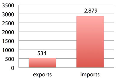
Official data show a $2.3 billion U.S. deficit in trade in GPS equipment in 2013. This gives an incomplete and misleading picture of the role of the U.S. and the benefits that result. See Figure 2.
Figure 2. U.S. trade in GPS equipment, 2013 (millions of dollars). (Chart: author)
The trade numbers for GPS equipment do not include revenue for licensing, international payments received by social media and e-commerce companies, or other Internet-based revenue for which the U.S. may have a substantial net trade surplus and which are an important source of revenue and profits of U.S.-based companies.
Imports of GPS equipment software and services enable the U.S. to gain more efficient production in many applications at home and enable the U.S. to export more goods and service that rely on GPS.
Exports of GPS equipment come back to the U.S. as components that benefit U.S. businesses and consumers with more capable products and lower prices. Exports of GPS equipment enable other countries to build on the technologies and contribute to innovation, while imports enable the U.S. to share in foreign innovations. Exports of GPS equipment and associated knowledge also raise incomes in other countries, creating larger markets for U.S. goods and services.
Scope of Benefit Estimates
The U.S. benefit estimates reported here are the result of an initial effort and are not meant to be comprehensive. More work is expected to be done to fill in some of the gaps.
Sectors were chosen based on availability of information to permit relatively robust estimates and importance to the economy or policy issues. These considerations limited the number of sectors for which estimates could be made. Methods were determined based on the nature of available studies and varied among sectors. Only economic benefits were included, with health and safety and environmental benefits left for later research.
Benefits include the value to users above their costs (consumer surplus). Benefits of GPS are compared with alternatives without GPS or an application using it (counterfactuals). Estimates are gross. They are not reduced by the costs of achieving the benefits. Contributions of augmentations are included, since a quantitative basis for separating them is not available.
Estimates were primarily benefits through productivity and cost savings in operations, with savings in input costs included where their magnitudes were clear. Benefits to the rest of the economy are not included. Illustrative allowances were made for the contributions of other technologies and systems to the outcomes examined.
In the case of GPS timing, the estimates were based on the costs avoided by not having to develop an alternative timing source on the assumption that the type of alternative source possible would have evolved from the time GPS became available. The measure does not represent the value of GPS time and synchronization to the nation and to users relative to the absence of a precise time and frequency source.
Government was included in the estimates for construction, surveying, and fleet and non-fleet vehicles. For timing and non-fleet vehicle benefits, two alternative measures are averaged. Sectors with lower quality estimates — rail and maritime transportation — were included because of their importance to the economy. Shares of benefits attributable to GPS were rough assumptions. More robust estimates would require extensive data collection and interviewing in studies greatly exceeding available time and resources.
The primary focus was on productivity improvements, cost savings and cost avoidance, where costs include users’ time. Productivity increases and cost reductions allow more to be produced with the same amount of resources in the sectors utilizing the technology or allow resources to be freed up for other purposes. In that sense, they are equivalent.
When benefits are measured by productivity gains or cost savings, much of consumer surplus (the value to users above what they pay) is implicitly included. Some sources measure value by willingness-to-pay. Willingness-to-pay includes consumer surplus. It also encompasses costs of the purchase and other costs incurred by the user.
Criteria for Selecting Sectors
The potential for making sector estimates of economic benefits was categorized in three basic levels:
confident: based on robust estimates.
indicative: based on one or more less robust estimates.
notional: illustrative, if major contributions of other technologies are not separated and estimates must be based on a plausible percentage of a larger benefit, or if information is not available and estimates must be based on a percentage of market size.
Choices among categories for estimation and estimation methods depended not only on which of the basic criteria are satisfied but also on the following additional criteria:
The importance of the sector to the economy, for example as an enabler of other activities.
The potential use of benefit estimates for the category as an input into analyses of the effects of signal disruption.
Several dozen studies were assessed to determine categories for inclusion and to select studies that can form the basis of estimation. Studies for use in estimation of benefits in a category were chosen according to how well they met the following criteria:
GPS. A test of introduction of GPS or comparison with and without GPS rather than benefits of a broader service.
Coverage. Estimates that cover a major part of the category.
Robustness of estimates, including the type of review the source is likely to have had.
Consistency. If alternative better estimates are not in such a wide range that an average is less meaningful except where explainable by expected sources of variation.
Timeliness. Preference to a recent period being covered by the estimates.
U.S. Economic Benefit Estimates
Preliminary estimates of economic benefits for included U.S. sectors totaled $55.8 billion in 2013. Averaging the alternative estimates, the sum of the benefits in the two vehicle categories is $25 billion, by far the largest of the sectors estimated. Next were agriculture with $13.7 billion, and surveying with $11.6 billion.
Economic benefits are underestimated for several reasons. Some sectors are not included because of lack of information on productivity and cost savings, namely LBS other than vehicle, including asset tracking and locating people; GIS and mapping other than nautical charts, forestry, fisheries, mining, energy exploration and development, land and coastal management, weather, and scientific applications and space.
Parts of others are not included: non-grain agriculture, construction other than earthmoving, GPS in aviation for some Area Navigation (RNAV) Standard Instrument Departure Routes (SIDs) and Standard Arrival Routes STARS) and Required Navigation Performance (RNP), and rail other than positive train control.
Some estimates are conservative. The value of saved time in non-fleet vehicle transportation is based on the recommendation of the Transportation Research Board rather than the much higher value used by the U.S. Department of Transportation.
Some types of benefits are not included — specifically, benefits of GPS timing applications above the cost of alternatives, and avoided income loss, property damage and medical costs associated with reduced accidents and improved emergency response.
Increases in benefits between 2003 and 2005 are not estimated.
And, as indicated, non-economic benefits such as those to health, safety, security, reduced loss of life and to the environment are not yet addressed.
Benefits as measured thus far are about 0.3% of GDP in one year. If all of the excluded sources of benefits were quantified, the benefits would be much larger.
Estimating Benefits for Sectors
U.S. economic benefits of GPS for grain farming were estimated for farms with grain sales of $250 million or more. The same method as was applied for earthmoving in construction.
A composite range of percentages of productivity gains and cost savings of 18–25% was determined from various studies. In the case of grain farming, benefits also come from yield increases due to improvements in plant health. The productivity gains used in the calculations incorporated both sources of benefits. Productivity was taken together with market size and an estimate of 68% adoption of technologies taking advantage of GPS to compute initial estimates of benefits. A notional adjustment was then made to exclude the contributions of other technologies and GNSSs. While having the adjustment determined by a group of experts would have been preferred, that was not possible with the time and resource constraints of the study.
Benefits of GPS machine guidance with earthmoving in construction were calculated based on an 8–12% share of construction for earthmoving operations, a benefit of 18–22% and a 20–25% adoption rate, relying on a number of sources.
For surveying, an estimate of market size was constructed based on U.S. Bureau of Labor Statistics data on numbers of surveyors, cartographers and photogrammetrists in the engineering services industry vs. the rest of the economy, together with revenue data for private surveying and mapping from the Economic Census. This was combined with a composite estimate of productivity gains over conventional surveying of 45–55% and an assumption of 100% adoption.
The benefit values for air transportation were estimated for the study by the Federal Aviation Administration (FAA) based on effects of WAAS and performance-based navigation (PBN). The rail estimates cover only positive train control, which is in early stages of implementation. Information is highly uncertain, but impacts as of 2013 are small. Maritime benefits were based on updating an earlier estimate of benefits of the private-sector value of nautical charts. The estimates for fleet vehicle-connected telematics were based on savings found in an extensive survey of fleet customers over a five-year period.
Timing benefits were based on the avoided costs from not having to develop an alternative source of timing. Alternatives considered were eLoran and a system of three geostationary satellites. Since there would have been strong pressures to develop an authoritative timing source in the absence of GPS timing, it was assumed that one of the alternatives would have been developed rather than assuming as in other cases that technologies in use when GPS became available would have continued in use.
Two estimates also were made for consumer and other non-fleet vehicle use. One was based on extrapolating results of a study of consumer willingness to pay for navigation services, and the other on time saved by navigation services.
Part of the benefits of LBS other than those that are vehicle-related and for GIS are implicitly included in estimates for sectors that use them.
Data and Research Needs
Additional work would be desirable to extend and refine the GPS economic benefit estimates, quantify safety-of-life and environmental benefits, examine international benefits, assess potential future benefits and consider loss from denial of GPS. Benefits of many new and rapidly growing services are yet to be quantified.
Systematic research is needed to fill in gaps in adoption, productivity and cost savings with comparative before-and-after studies as well as with case studies. Robust studies require major and often multi-year efforts involving targeted data collection, which are rarely done by government or academics for GNSS. Information needs to be much more granular, taking into account specific functions in which GNSS is used (such as plowing, seeding, fertilizing, harvesting), specific GNSS and non-GNSS technologies employed in each function at each site, and extent of their use.
Also, results for GPS might be improved or at least be more acceptable if the contribution of other technologies and GNSSs to measured benefits were assessed by a group of knowledgeable individuals rather than by a single researcher.
Information on market size, penetration and growth from market research firms, which tends to capture recent developments, is based on greatly varying sources and methods, resulting in major gaps and great divergence in estimates, especially in new or rapidly growing areas like LBS and GIS. The North American Industrial Classification System (NAICS) and its application in federal data collection such as in the Economic Census lags far behind in recognizing new categories and providing sufficient detail. Lags in data collection and research lead to understatement of the use and benefits of GPS.
Looking to the Future
Future benefits are expected to be even greater because of evolution of technologies, expansion of GNSS systems, creation of new products and markets, and growth and penetration of markets. The possibilities are suggested by the numerous nascent applications that have been emerging. Many will be enabled by expanding GNSS systems, signals and capabilities in conjunction with geographic expansion and increased capabilities in wireless systems.
The progression of platforms is long and growing: mainframes, PCs, mobile phones and other handheld devices, tablets, game controllers, wearables, TVs, home appliances, air and space — including planes, UAVs, satellites, planets, moons, rovers, rockets and spaceships.
The widespread availability of platforms and the growing ability to utilize them promises a long way to go in developing applications and deriving benefits.
Acknowledgments
The author thanks the PNT Advisory Board and Gov. Jim Geringer, liaison from the board to the study; Jason Kim of the Department of Commerce who oversaw the project; Jim Miller of NASA; and the members of the interagency Economic Study Team that advised the effort. Numerous additional people in and out of government provided information and assistance. Responsibility for the content and findings rests with the author.
IRV LEVESON, who has a Ph.D. in economics from Columbia University, is an economic and strategy consultant and founder of Leveson Consulting. He has done extensive work on GNSS markets and issues for more than 10 years. He is a member of the Institute of Navigation, the American Economic Association and the National Association for Business Economics.
GlobalTop Technology has launched FireFly X1, a tiny Mediatek-based multi-GNSS module. With a compact size of 9.0 x 9.5 x 2.1 millimeters, it’s one of the smallest multi-GNSS modules in the industry, the company said.
“Compact size and low-power consumption will be the key [unique selling points] for the next generation of M2M Devices,” said Sam Khan, vice CEO of GlobalTop Technology. “After a comprehensive market study, we found that small size was one of the most important factors for companies when it came to GNSS module selection; other key factors included power consumption, TTFF, positioning accuracy, additional interfaces as well as quality and longevity of the module. I am proud to say that FireFly X1 delivers perfectly on all these criteria.”
According to Khan, the FireFly X1 was designed with “sophisticated engineering and an entirely new set of ultra-compact quality components to reach this miniature size, while adding more features and interfaces at the same time.” It uses the latest MT3333 engine with full support for GPS, QZSS, GLONASS and BeiDou, and is Galileo ready.
Tracking of up to two constellations simultaneously, and relying on the latest Mediatek firmware, it can provide positioning accuracy of up to 1.8 m CEP. Enabling EASY (self-generated orbit prediction), AGPS (ephermis file injection) and SBAS further enhances position accuracy.
Despite a smaller size, FireFly X1 incorporates a complete set of high-quality components, including TCXO, RTC Crystal, SMPS, SAW Filter and an additional LNA to provide reliable performance.
FireFly X1 combines miniature size with flexible multi-interface connectivity options such as SPI and I²C that can simplify a user’s design, and is designed for M2M devices relying on low-cost MCUs that offer limited serial interfaces.
GlobalTop’s free customization service further expands the capability of FireFly X1 with features such as custom NMEA output sentence, distance calculation, geofencing, magnetic variation and last- position-retention. Advanced users can also customize the basic parameters of the module, including baud rate, update rate, internal logger settings, DGPS mode, 3D Fix, 1 PPS timing, and more.
All modules are produced at GlobalTop’s in-house ISO 9001:2008 certified manufacturing facility, with 100 percent unit testing and complete quality control, allowing for a consistent annual yield rate of 99.98 percent.
Samples and Evaluation Kits for FireFly X1 are now available. Please contact us or your local distributor for more information.
TobyRich has integrated OriginGPS’ Nano Hornet into a smartphone-controlled gaming drone line, to extend its range and enhance its directional capabilities. By leveraging the Nano Hornet, a tiny GPS module with an integrated antenna, TobyRich was able to design a smaller, sleeker form factor for its innovative drones while taking advantage of OriginGPS’ performance and low-power consumption features, according to TobyRich.
TobyRich, established in 2011 and with deep experience in designing smartphone-controlled drones, launched a Kickstarter campaign that will run until Aug. 28 to offer a new, more interactive experience for video gamers and drone enthusiasts across the globe.
The agile drones blend realistic flight maneuvers with innovative interactive gameplay and are designed to resemble an airplane rather than a quadcopter to extend flight time and carry more payload than traditional drones without compromising on functionality or performance. The drones can easily be controlled within a range of 90 meters via the tobyrich.red mobile app, which is available on iOS and Android.
TobyRich’s drones combine the immersive experience of video games with the exhilaration of real flight to unlock possibilities such as mid-air battles, races, stunts and other gaming scenarios, plus additional applications such as aerial photography and video, the company said. Single and multiplayer gaming modes enable video gamers to live out their flight fantasies with friends or solo. To meet users’ exact interests, several different versions are in development, including the basic tobyrich.vegas model, tobyrich.tokyo, which features a HD camera, and tobyrich.guru, a 4G/LTE-enabled drone.
With the help of OriginGPS, a TobyRich drone knows exactly where it is in relation to a user’s smart device, with unprecedented accuracy, allowing it to respond immediately and precisely to gesture controls or on-screen joysticks. OriginGPS’ location capabilities ensure that a drone will automatically return to its point of origin or a pre-programmed destination if it strays too far from its corresponding smart device or flight path, which reduces user frustration, minimizes human error and increases safety.
Measuring 10 by 10 millimeters, the OriginGPS Nano Hornet module powers TobyRich’s flight management system by achieving a rapid time to first fix (TTFF) of less than one second, with approximately 1 meter accuracy and -163 dBm tracking sensitivity, and it uses OriginGPS’ proprietary Noise Free Zone technology to increase sensitivity and minimize interference. It achieves a state of near continuous availability, while consuming microwatts of battery power, ensuring maximal power is devoted to increasing drone flight times. Because OriginGPS’ modules are complete, plug-and-play solutions, they significantly shorten time to market and dramatically reduce engineering risks, the companies said.
Fleet management company Omnitracs LLC will develop telematics software for Volvo Trucks North America and Mack Fleet Management Services for Mack Trucks. The two separate memorandums of understanding will provide customers of both Volvo and Mack Trucks with fleet management services such as routing and predictive analytics solutions.
According to Omnitracs, the agreements represent a move toward standardization in the trucking industry, making it easier for fleets to better control costs, safety, vehicle management and diagnostics, driver workflow and compliance. It also paves the way for other strategic partnerships within the OEM network, the company said.
“This partnership brings together two leading brands in the vehicle and technology space, and addresses the industry’s growing need for high-tech trucks offering improved productivity and compliance. As the Internet of Transportation Things moves beyond concept to reality, Omnitracs will continue to lead and become part of the larger ecosystem of OEMs that are redefining the traditional telematics landscape,” said Rich Glasmann, vice president of OEM strategy, sales and marketing for Omnitracs.
Tallysman, a manufacturer of high-performance GNSS antennas, has launched a higher gain dual-frequency embedded antenna: the TW3870E. The TW3870E antenna has a typical gain of 35 dB which is required by some GNSS receivers, such as Trimble’s BD9xx family of receivers.
The antenna is capable of receiving GPS L1/L2 and GLONASS G1/G2 signals. It employs Tallysman’s Accutenna technology, which can provide low axial ratios, high multi-path signal rejection, low noise, tight PCV and a phase linear response.
The TW3870E is 60 mm in diameter and has four drilled plated holes for secure mounting within customers’ products. The antenna can be custom tuned to ensure optimal performance. Custom cable lengths and connectors are also available.
The antenna is REACH and ROHS compliant.
Visit Tallysman’s booth at INTERGEO 2015, Hall E8, Booth 038 to learn more about the TW3870E and other Tallysman antennas.
The Institute of Navigation (ION) GNSS+ conference is scheduled for Sept. 14-18 this year, just down the road in Tampa, Fla. It’s just over an hour’s drive for me, so I’ll be there again this year.
The reminders from ION have started to show up in my inbox, touting issues like PNT privacy, a new UAV session, a return of the popular indoor navigation demonstrations with a significantly larger group of companies demonstrating, an update on what’s happening in indoor navigation regulation-land, and with a number ways to find out what’s happening on social media. So most GNSS industry people will now have their reminder to register, get a hotel room and choose the sessions they want to attend for their week in Tampa.
GPS World will be there as usual with our full team, including our market-sector editors, along with near-real-time coverage of the show on GPSworld.com and on Twitter. The exhibition floor looks to be almost full, so if you were sitting on the fence thinking about exhibiting, its probably time to make a decision — there only appear to be a few booths still open.
GPS World will also video record the indoor navigation demonstrations, and portions will be posted online at the GPS World YouTubechannel.
Also, come by the GPS World booth during the exhibit hall reception Wednesday evening to film a video-selfie with Mary Ann, our August cover great white shark. The video-selfies give you 30 seconds to tell us about yourself, and will be posted to our YouTube channel.
The CGSIC (Civil GPS Service Interface Committee) meets and tutorials will be held on Monday and Tuesday, but the week basically gets going with the plenary session on Tuesday evening.
James L. Green, director of Planetary Science for NASA.
This year, ION has called on Dr. James L. Green, director, Planetary Science at NASA, to give an insight into NASA’s interplanetary exploration over the last several years. He plans to take us “on a journey navigating our way through the Solar System showing you new worlds and new discoveries through the eyes of our planetary spacecraft.” In the last several years alone, the understanding of the origin and evolution of the solar system has changed dramatically. He’ll demonstrate how our foundations of knowledge have literally been reestablished.
Technical papers and applications sessions get rolling bright and early on Tuesday morning.
Then the exhibit hall opens up at 10 a.m. on Wednesday, with more than 50 GNSS and related exhibitors from around the world showing their new products and innovations. Exhibitors range from GNSS systems manufacturers to simulation, timing, engineering and system integrators, chip and receiver manufacturers, antenna and RF component suppliers, test-solution suppliers, indoor location experts, inertial navigation companies, government and R&D agencies, military and commercial GNSS suppliers, satellite system and component providers, survey-systems suppliers, and a smattering of Internet of Things (IoT) proponents. The exhibit floor runs Tuesday through Thursday in parallel with the applications presentations and panels and technical papers.
The show floor at ION-GNSS 2014.
Key application presentations for me to catch include the indoor location demonstrations on Wednesday afternoon, and the new UAV navigation session on Thursday morning. But there are around four parallel presentations on systems and applications and four sessions of technical papers each morning and afternoon Tuesday through Friday, so there are enough topics on a huge range of GNSS and related navigation technologies that would satisfy almost anyone in the industry or anyone wanting to learn about the industry.
Indoor Location Demonstration
The list of vendors who plan to demonstrate at the indoor location demonstration session is lengthy:
Nokia
InvenSense
RX Networks
Indoor.rs
Samsung
CSR
Combain
Pole Star
ByteLight
Microsoft
That’s about twice as many participants as last year, when the audience was treated to a number of demos that worked, and some which basically didn’t. So, this is an opportunity to redeem themselves for those who had problems, time to update and show improvements over last year for the ones who demonstrated successful indoor navigation, and for the newcomers, we shall see what they have to offer. Hopefully, companies will have recognized that it’s essential to a have a large-screen display replicating handhelds for a large audience to follow what’s going on.
UAV Session
The UAV session appears to concentrate on alternate navigation and other sensors for unmanned airborne vehicles. Papers include modeling and calibration to remove magnetic biases coming from other devices on the platform; a kind of indoor navigation for micro-UAVs entering buildings for assistance in disaster conditions; navigation using optical imaging with and without GNSS; Stanford’s JAGER jammer detection project using DME and ADS-B signal navigation; and integrity requirements for UAV sense-and-avoid systems. Another panel session on Friday discusses integration of UAVs into the U.S. National Airspace System.
If these couple of topics don’t fire you with enthusiasm, don’t worry – there are masses of other great topics to pick from in the extensive technical program at ION GNSS+. Right now, pre-registration for ION GNSS+ is running 26 percent ahead of where it was last year, so we could have 1,300-1,400 technical attendees this year.
So, come on down to Florida – yes, it’s warm (the Convention Center is air conditioned), but its not too warm — even for a guy like me from the frozen North!
A new GNSS market research report by research firm RNCOS forecasts the global core GNSS market to grow at a Compound Annual Growth Rate (CAGR) of 9 percent during 2015-2020.
The GNSS industry includes technology that allows any user having a compatible device to determine their position, velocity and local time by processing signals from satellites in space. Signals include GPS, Galileo, GLONASS, BeiDou and regional SBAS. The GNSS market includes both products (receivers and devices) and services using GNSS-based positioning as a significant enabler.
In the latest research study “Global Navigation Satellite Systems Market Outlook 2020,” analysts identify and decipher the market dynamics in important segments, highlighting the areas offering promising possibilities for companies to boost their growth. The report studies the market by its major application and location-based services, transportation (further divided into road navigation, rail navigation, air navigation and marine navigation), surveying activities and agriculture.
The GNSS application market is further studied by region — North America, Europe, Asia-Pacific, and Rest of World. The report provides a complete overview of the GNSS market globally. All the current trends and drivers coupled with potential growth areas of the GNSS industry have been evaluated in the report. Furthermore, the report provides knowledge of opportunities in the industry for different companies in the “Opportunity Assessment” chapter.
Additionally, to provide an exhaustive knowledge of the prospects for GNSS players on the geographical front, the report provides a comprehensive knowledge of the 10 most worthwhile GNSS markets around the world: U.S., Canada, UK, France, Germany, Russia, Japan, China, South Korea and India. It includes information about the present state and future outlook of the LBS and telematics market in these countries, along with information about their personal navigation systems with the U.S.’s GPS, China’s BeiDou, Europe’s Galileo, Russia’s GLONASS, Japan’s QZSS and India’s IRNSS.
Finally, the study looks into the competitive landscape covering business overviews, key financials, product analyses, recent developments and strengths and weaknesses analyses of each of the players. All in all, the report is intended to help clients analyze the driving forces and understand the opportunities in the industry.
Lime Microsystems and Airbus Defence and Space, with funding from Innovate UK (formerly the Technology Strategy Board), will jointly be developing robust GNSS products, according to a Lime Microsystems blog. Airbus D&S, using Lime’s Field Programmable RF (FPRF) transceiver technology, is developing a robust timing receiver that exploits signals from the new Galileo satellite navigation constellation.
A highly integrated Field Programmable RF (FPRF) solution based on Lime’s technology, and an innovative system implementation of the kind provided by Airbus D&S, will provide a high-performance GNSS product with the potential for integration with other wireless capabilities, the companies said.
“Lime FPRF transceiver matches our rigorous technical performance requirements and we are looking forward to be working alongside Lime in this strategic engagement,” said Mike Turner, Airbus D&S.
“We are delighted to be working with Airbus, supporting a complimentary technology that could impact variety of applications such as wireless infrastructure,” said Ebrahim Bushehri, CEO of Lime Microsystems.
Qualcomm Incorporated announced Thursday that its subsidiary Qualcomm Global Trading Pte. Ltd. has completed the acquisition of CSR. CSR is known to the GPS/GNSS industry as the maker of the SiRFstar series of chips, which are used in many consumer devices.
Qualcomm started the acquisition process for CSR in October 2014. With this close of the acquisition, Cambridge Silicon Radio Limited, or CSR, is renamed Qualcomm Technologies International Ltd.
The acquisition, which was completed at an enterprise value of approximately $2.2 billion, complements Qualcomm Technologies, Inc.’s offerings by adding a compelling portfolio of new products, sales channels and a large number of customers in the areas of IoE and automotive — both key growth priorities for Qualcomm Technologies.
Cambridge Silicon Radio Limited is an indirect, wholly-owned subsidiary of CSR that operates, along with its affiliates, substantially all of CSR’s engineering, research and development functions, along with substantially all of the CSR products and services businesses. Cambridge Silicon Radio Limited will be renamed Qualcomm Technologies International, Ltd., which will become a subsidiary of Qualcomm Technologies.
“As we strive to connect billions more devices, automobiles and people within the Internet of Everything, we are enthusiastic about the growth that this combination will foster,” said Steve Mollenkopf, chief executive officer, Qualcomm Incorporated. “CSR’s complementary strengths in connectivity, audio technologies and systems-on-chips will help strengthen Qualcomm Technologies’ position in the IoE and automotive industries, and add to a broad and highly advanced portfolio.”
“We are pleased to join a recognized leader such as Qualcomm Technologies at an exciting time as customers race to satisfy the growing consumer desire for more and more seamlessly connected devices in their ‘smart’ homes, offices and cars,” said Joep van Beurden, chief executive officer, CSR. “Our employees have a strong history of pioneering new products and collaborating with customers to deliver critical technology requirements such as interoperability, low power and connectivity. Together with Qualcomm Technologies, we are better positioned to meet our customers’ needs today and into the future.”
While the accounting for the transaction is not yet finalized, Qualcomm estimates that on a Non-GAAP basis the acquisition will be modestly accretive to earnings per share in fiscal 2016 consistent with prior guidance. In addition, based on preliminary estimates, Qualcomm expects the transaction to be modestly dilutive to GAAP earnings for fiscal 2016 driven primarily by acquisition-related items.