NVS Technologies AG has launched an L1 RTK+Heading GNSS receiver. The NV08C-RTK-A is fully integrated multi-constellation satellite navigation receiver with embedded RTK functionality and compatibility with GPS, GLONASS, Galileo and BeiDou.
NV08C-RTK-A is specifically designed for use in high-accuracy applications, demanding low-cost, low-power consumption, small form factor and high performance, such as construction, mining and industrial; environmental and structural monitoring; machine control and automation; parallel driving systems; precision agriculture; UAVs; and robotics and intelligent machines.
More Features
L1 GPS, GLONASS and SBAS
Centimeter-level positioning in RTK mode
Enhanced RAIM for 3D and RTK modes
Three-stage filtration for high out-of-band interference immunity
Industrial operating temperature range -40°C to +85°C
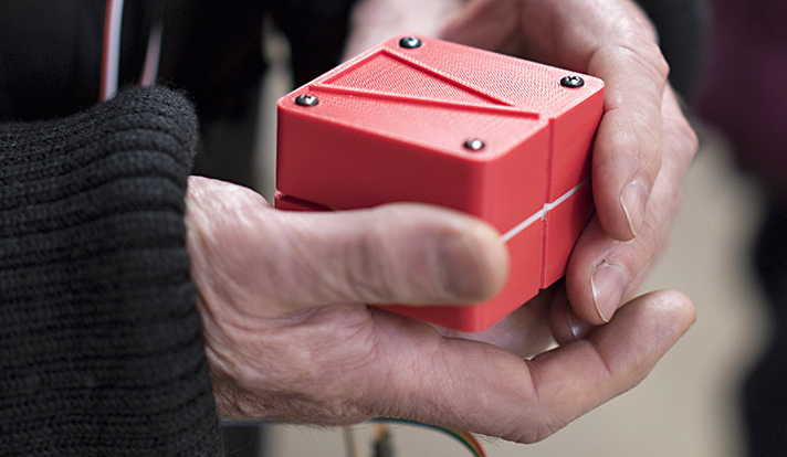
A handheld GPS device uses touch to help you determine where to walk. Made with a 3D printer, the cube-shaped “Animotus” was designed with the visually impaired in mind, reports YaleNews.
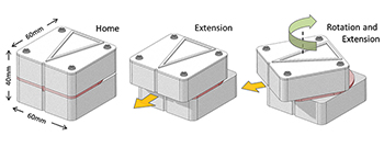
Designed by Adam Spiers, a Yale University post-doctoral associate in mechanical engineering, the Animotus is designed in layers, with the receiver in the middle. The top layer revolves to show what direction to walk, extending to indicate distance.
When it stops twisting and returns to its cube shape, you’ve reached your destination. It can be programmed wirelessly on a computer or a smartphone.
Spiers said he chose touch for guidance over sound because of the many aural distractions.
(Diagram: YaleNews)
The Animotus was tested in London in an immersive production of a play based on the novella Flatland, about a two-dimensional world. Using the Animotus, the audience was guided through the church to uncover the plot. When the Animotus signaled participants to stop, narrative and sound effects took over. The performing company includes sight-impaired members.
The Animotus was demonstrated at the World Haptics Conference in June at Northwestern University and received “quite a bit” of interest, Spiers said.
OriginGPS has launched a new family of products, the first of which is the ORG1510-MK Multi Micro Hornet, a fully integrated multi-GNSS (GPS, GLONASS and BeiDou) module. The miniature low-power architecture supports an update rate of up to 10 Hz and contains onboard flash. It is designed to provide a GNSS component to devices that require fully featured components with small footprints, such as UAVs designed to follow action sports and other fast-moving activities or wearables.
OriginGPS released the Multi Micro Hornet (ORG1510-R01) in June, which tracks GPS and GLONASS, but not BeiDou. The ORG1510-R01 uses a SiRFstarV GNSS system on chip.
The ORG1510-MK contains the MediaTek MT3333 chip, which supports a fast update position calculation rate. The chip also contains an onboard flash memory that does not erase when power is off. It consumes very little power with the use of both standby mode and backup mode, and, in advanced applications, a periodic mode that can turn the device on and off when in backup or standby.
“The inclusion of MediaTek has enabled the creation of the most powerful GPS module on the market,” said Gal Jacobi, CEO of OriginGPS. “The ORG1510-MK’s tremendously fast update rate, low power consumption, miniature size and reliable accuracy makes it possible to track life’s most exciting and fast-paced activities without delay, battery drain, or clunky devices. It will be a meaningful engine of growth for OriginGPS in Asia Pacific and globally.”
Key features of the New Multi Micro Hornet include:
Rapid update rate and superior memory – The Multi Micro Hornet has an update rate of up to 10 Hz and onboard flash, supporting a significantly higher accuracy than the standard update rate of 1 Hz and low power consumption due to the module’s ability to store hours of data.
Smallest size, highest performance – Despite the Multi Micro Hornet’s tiny size of 10 x 10 mm and height of 6.1 mm, the module offers superior sensitivity and outstanding performance, achieving rapid time to first fix (TTFF) of less than 1 second, accuracy within as little as 1 meter, and sensitivity at -165 dBm for two constellations simultaneously.
High sensitivity and noise immunity – The ORG1510-MK continues to leverage OriginGPS’ patented and proprietary Noise Free Zone (NFZ) technology to ensure high sensitivity and noise immunity even under marginal signal conditions.
Continuous connectivity with minimal power consumption – The low power consumption modes aided by MediaTek include a standby mode, during which the RF and baseband enter low power mode, and backup mode, during which the internal PMU turns off and only keeps the VRTC domain alive. For advanced applications, the module can periodically turn its operation on and off when in backup or standby mode.
An intelligent design that shortens time to market – The Hornet family of GPS / GNSS antenna modules integrates a GNSS receiver and patch antenna in a single module. As a cornerstone of the OriginGPS portfolio, the ORG1510-MK pin-to-pin compatibility with the Micro and Nano Hornet modules ensures a seamless migration from GPS to GNSS and gives developers the ability to create new product offerings in the shortest time to market while minimizing costly design risks. Developers can simply connect it to a power source on a single layer PCB to begin integrating it into their designs.
The ORG1510-MK module combines OriginGPS’ proprietary low-profile GNSS antenna with a dual-stage LNA, RF LDO, SAW filter, TCXO, RTC crystal and RF shield.
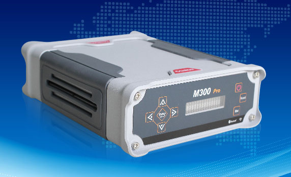
ComNav has released the M300 Pro, a CORS GNSS receiver, and the K528G, a new GNSS OEM board for heading.
Designed for reference stations, the M300 Pro tracks GPS, GLONASS and Beidou (B1, B2, B3), and will track Galileo, QZSS and other coming constellations. Its web server function enables easy and convenient remote control. The M300 Pro is compatible with many kinds of CORS software, using the standard data format RTCM and the various data transfer protocols such as UDP, TCP and Ntrip.
Raw GNSS observation data can be saved in Rinex format and remotely downloaded. The M300 Pro contains multiple ports, which can configure and connect with external sensors, including but not limited to meteorological sensors, barographs and inclinometers. The PPS output function provides a guarantee for precision timing. The M300 Pro also has the functionality of event mark and external memory.
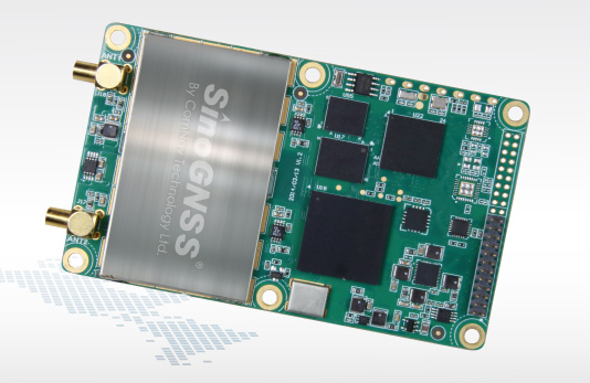
The K528G GNSS board.
The K528G is a dual-frequency and multiple constellations GNSS board that provides the highest accuracy in differential positioning. K528G benefits from plenty of constellations signals, due to its advanced tracking performance of both GPS and GLONASS. The K528G can provide positioning and heading information generated by two antennas.
The K528G is designed for guiding and positioning construction engines, dredges, barges, shipping container cranes, mining equipment and intelligent transportation systems.
The 2015 edition of the European Satellite Navigation Competition GSA Special Prize was awarded to Rafael Olmedo for the KYNEO project. The project develops inexpensive, flexible Galileo and EGNOS enabled modules that allow ubiquitous positioning data for applications in the Internet of Things. Other winners of the competition are listed here.
Described as an open innovation platform for the GNSS of Things, the basis of the KYNEO concept is a perceived need to be able to fast prototype applications and devices in the rapidly developing field of the Internet of Things. According to Olmedo, a variety of Internet of Things platforms are looking for positioning systems that can be flexible and adapted to a variety of situations and circumstances. To serve this objective, the product works as an open-source software for the creation of interactive electronic objects.
REMINDER: For continued undisturbed use of GPS as Internet use mushrooms, led by the booming Internet of Things, more efficient utilization of spectrum bandwidth on all sides is essential; for this, synchronization is key. Timing experts will share their views during GPS World‘s “Timing, Time Transfer and Synchronization: New Applications and Techniques” webinar sponsored by EndRun Technologies on Thursday, Oct. 29. Registration is free.
“There is a huge development community for digital electronic products out there, and our aim with KYNEO is to provide a great positioning tool for this community,” Olmedo said. “The first KYNEO products are already available to order via our website, but we will also sell via the many open hardware platforms that already serve the developer community.”
“The Internet of Things is a potentially massive global market for European GNSS programs, offering many benefits to the end users,” said GSA Executive Director Carlo des Dorides. “Open source programmes like the KYNEO project will not only prove to be competitive in their own right, but will also open doors to related services and other opportunities.”
The project was selected from a record-breaking 192 entries. Entries came from 29 different countries, with 72 entries coming from individuals and 59 from start-up companies. The award was announced during a special awards ceremony, held on the opening day of the Satellite Masters Conference in Berlin.
About the European Satellite Navigation Competition
Since 2004, the European Satellite Navigation Competition (ESNC) has been rewarding the best services, products, and business cases that utilize satellite navigation in everyday life. Over this time, ESNC has evolved into an international innovation competition — one that recognizes the best ideas in the field of satellite navigation. Entries come from a wide range of companies, research institutes, students and individuals.
“The GSA Special Prize nicely complements the Agency’s focus — getting closer to the end user and helping them benefit from European space technology,” des Dorides said. “Whether through competitions like this, or through such funding programmes and Horizon 2020 and Fundamental Elements, it’s by supporting innovative applications like KYNEO that the GSA will be able to succeed at its mission.”
Each year, the GSA Special Topic Prize awards the most promising European GNSS application idea. The winner of the GSA prize has the opportunity to realise his or her idea at a suitable EU incubation centre for six months, with the option of an additional six months based on evaluation after the first period. The award criteria is based on the uniqueness and originality of the idea, its business (and social) potential, the credibility of the corresponding team, and the application’s use of unique EGNOS/Galileo features.
PCTEL Inc. has launched a new GNSS multi-satellite antenna portfolio for mobile and base-station timing applications. PCTEL’s new SkyLink antenna technology features out-of-band rejection characteristics that provide exceptional GPS/Galileo and GLONASS L1 support and performance in heavy RF traffic environments for fixed and mobile timing and asset tracking applications.
The new portfolio consists of two product lines:
SkyCompass for fleet management and asset tracking applications
SkyStamp base-station antennas for timing and synchronization of 4G LTE cellular networks.
SkyCompass comprises six new configurable antenna platforms, including single-band or multiband GNSS options that address the majority of fleet management installation needs. SkyStamp offers two timing reference and synchronization antenna models that provide maximum mitigation of the effects from nearby LTE interference sources.
“Over the last decade, PCTEL has been the industry’s technology leader in high rejection GPS products. These antennas are deployed worldwide by OEM customers in aviation, defense, and fleet management public safety projects,” said Rishi Bharadwaj, vice president and general manager of PCTEL’s Connected Solutions. “True to our commitment to support global communications and evolving requirements, PCTEL’s SkyLink technology provides global multi-satellite GNSS coverage and precision tracking by rejecting RF noise or interference that can negatively affect communications in performance critical situations.”
SkyCompass and SkyStamp antennas will be available for shipment in November.
Baseband Technologies Inc. has been issued a patent from the United States Patent and Trademark Office for its low-power satellite positioning innovation. U.S. Patent No. 9,116,234, titled “System, Method and Computer Program for a Low Power and Low Cost GNSS Receiver,” describes the technology and processes to significantly reduce the energy required to operate a GPS receiver.
Baseband’s ultra low-power GPS receiver technology enables consumer electronics manufacturers to integrate its receiver into battery-powered wearable/Internet of Things (IoT) devices using hundreds of times less power than the traditional GPS chipsets.
“With the wearable market projected to grow multiple times faster than smartphones and with GPS being one of the most requested features, there will be huge rewards for those manufacturers who can offer GPS functionality in their products without impacting the battery life or size,” said Francis Yuen, founder and CEO of Baseband. “For us, innovation is about connecting what is possible with what is valuable to our customers. This patent, in conjunction with others now pending, will enable Baseband to continue to offer ultra low-power positioning capabilities and customer-centric experiences across different market verticals.”
“It is gratifying that the US Patent and Trademark Office has recognized both our invention and the intellectual property of this very promising technical advancement,” Yuen said. “This newly granted patent will certainly help in our current investment round as well as to fuel continued product development and innovation that will lead to even further advances in ultra low power positioning.”
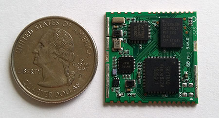
SkyTraq’s S2525F8-BD-RTK multi-constellation RTK receiver is designed for UAV and mobile platforms.
SkyTraq Technology, a fabless GNSS positioning technology company, is introducing the S2525F8-BD-RTK, a cost-effective, low-power single-frequency RTK receiver for unmanned aerial systems and mobile platforms requiring centimeter-level position accuracy.
The S2525F8-BD-RTK multi-constellation RTK receiver supports GPS, BDS, QZSS, and SBAS, simultaneously tracking up to 28 satellites. With its 25 x 25 millimeter form factor, 300-mW power consumption and 3 gram weight, it is designed for any outdoor applications requiring high-precision RTK positioning.
S2525F8-BD-RTK supports both base station and rover modes. As a rover, it receives RTCM 3.0 or 3.1 data from a base station, or raw measurements from another S2525F8-BD-RTK receiver serving as base station, and performs carrier phase RTK processing to achieve relative positioning with 1 cm + 1 ppm position accuracy within 10-Km baseline.
Its compact evaluation board has serial interface connector supporting direct connection to Ardupilot and Pixhawk autopilots for UAS testing. A Bluetooth 2.1 module is included on-board to simplify outdoor evaluation using Bluetooth-connected smartphone or tablet to receive remote base station data via NTRIP client software over the Internet.
S2525F8-BD-RTK engineering sample, datasheet, reference design and evaluation kit will be available in October. Volume production delivery to customer begins in November 2015.
The ION GNSS+ 2015 Conference once again fielded a jam-packed agenda of papers on subjects from world-wide constellation updates, through GNSS integrity, indoor navigation demonstrations, multi-constellation/function chipsets, interference mitigation and jamming detection, privacy issues, and many other very interesting subjects. That’s GNSS+ in the conference name, as in “plus,” denoting the many other positioning, navigation, and timing technologies it covers.
Most papers contained advanced academic research, but there were also several new industrial releases. This year ION divided and clearly differentiated sessions between “System and Application Tracks,” that is, those with more direct industry content, and “Peer-Reviewed Tracks,” the so-called “pure” research.
As always, some of the most valuable takeaways of attending ION come from the numerous unrelated, off-the-record corridor conversations: an essential element, always spontaneous and much anticipated, but something that cannot be clearly identified nor put into the program.
The conference seemed to have around the same number attendees as last year with about the same number of exhibitors, even though a few of the big booths were missing. Paradoxically, some exhibitors privately said they did better and more business this year, even with fewer attendees, according to their estimates.
SPIRIT Navigation from Moscow did not have a booth, but Ruslan Budnik made sure to fill my notepad with lots about their technology, products and initiatives. They are among several companies working to add indoor navigation capability to smartphones, using existing onboard sensors and new intelligent software. Their solution concurrently uses multiple technologies including geomagnetic fingerprinting, pedestrian dead reckoning, and map matching, but does not rely on an installed beacon infrastructure. A Spirit app allows store operators to quickly map Wi-Fi and Bluetooth signals and collect a Magnetic field map which matches the floor plan of the store’s venue. Spirit claims an accuracy of around 1 meter, which Ruslan proceeded to demonstrate to me in the corridors around the ION meeting rooms.
Theplenary session on Tuesday night was very interesting with a presentation on the results of NASA’s planetary exploration over the last several decades, by Dr. James Green, NASA Director or Planetary Science. I learned a lot about our solar system; much more out there than one suspects, and much to be revealed in the next few years!
GPS World editor Alan Cameron once again led a preview of the planned sessions for the week, with each session chair constrained to a 5-minute rapid-fire presentation aimed at enticing as many attendees as possible. Interesting and somewhat humorous at the same time; we still got a flavor of what was to come in each track.
On Wednesday I was fortunate to be able to interview several show exhibitors. Some of these you will also find in video footage on the magazine’s website, speaking to you straight from the show floor.
Skydel is a relatively new exhibitor, working with Averna, both from Montreal, Canada. Averna makes signal analysis hardware on which Skydel installs software-based simulation of GNSS signals. Skydel’s objective is to be able to make their solution so affordable that every engineer could have one of these record and playback simulators on their desk, rather than having to schedule time on a central, shared multi-function simulator. An exciting new-entry product developed by an energetic group of people with a high level of ingenuity; hopefully they will succeed.
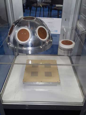
DLR antenna prototypes
A robust receiver initiative from Deutsche Zentrum für Luft- und Raumfahrt (DLR), the German Aerospace Center, aims to demonstrate that jamming and interference detection and mitigation can be achieved much more effectively than just at the RF level. Their processing goes deeper with such features as knowing that a source from a particular direction isn’t aligned with the current constellation, so it’s a jamming/interference suspect. Their conformal antenna development attempts to meld an antenna configuration with their signal processing capabilities. DLR is looking for partners to put these developments into commercial receiver applications.
ComNav has a new K700 family of receivers: K-700 GPS L1, Beidou B1 and Glonass L1 80 channel receiver — added to their K-708 dual frequency 198-channel dual-frequency version. The M300 Pro GNSS Receiver package includes a weather-hardened package, multiple interfaces which enable remote internet control and data access, memory and a rechargeable back-up power supply. ComNav claim the M300 Pro has been selected for the Chinese CORS network. ComNav also anticipates a name change in the near future: SinoGNSS will be their new company name.
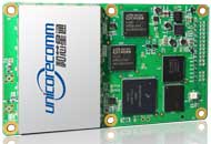
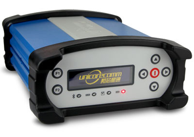
Harxon antennas and radiosUnicore UB370 Beidou/GPS/Glonass multi-frequency OEM receiver
Harxon gave us an overview of their wide range of antenna and radio products, while Unicore in the next booth described their single and dual frequency receivers which they are now promoting extensively in North America.
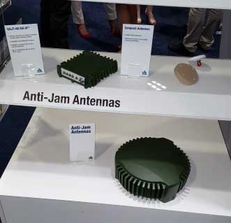
NovAtel GAJT antijam systems
As usual, NovAtel had a wide range of products on display. I was impressed that the mil-spec GAJT anti-jam product-line has now undergone testing by both the U.S. and Canadian military, and that the GAJT-AE is now flying and providing guidance protection in hostile jamming environments. Once again there were mentions of NovAtel receivers and antennas being used for research in several technical papers at the conference.
Septentrio continues to make further inroads into the high-precision GNSS receiver market, and announced several new key initiatives. The company has been selected by UNAVCO as the Geodesy Advancing Geosciences and EarthScope (GAGE) facility preferred vendor for next-generation GNSS reference station products. UNAVCO ( ) is a non-profit university-governed consortium, facilitating geoscience research and education using geodesy.
AsteRx-U dual antenna receiver
Septentrio is developing a next-generation reference receiver with UNAVCO’s inputs and evaluation feedback for the purpose of upgrading and renewing their GNSS networks. Septentrio also launched the AsteRx-U and the AsteRx-U Marine multi-constellation dual antenna receivers which incorporate the latest GNSS tracking and positioning algorithms and interference mitigation along with integrated UHF radio, Wi-Fi, USB, Bluetooth, cellular connectivity, and a spectrum analyzer which provides users with their interference profile.
Indoor Navigation
ION’s annual Indoor Navigation Demo session on Wednesday afternoon turned out to have more slides and pre-recorded testing content than actual demonstrations. The participants included Nokia HERE, Rx Networks, SPIRIT Navigation, TRX Systems, Broadcom, Indoors and Combain.
HERE was able to initially demonstrate some indoor tracking of an equipped cellphone, but the display for the audience appeared to quit after a short period. They did provide a link to allow attendees to download their software and try it for themselves.
Rx Networks is apparently focusing on self-location for indoor guidance assets, and ran a pre-recorded demo of ‘Zed’ in a Vancouver Mall – but the vertical tracking display part of the video was completely washed out for the audience.
SPIRIT Navigation ran a recording of the demo I had witnessed earlier – a quite effective, working indoor nav application on a smartphone – and then walked around the demo room, but wasn’t able to show real-time results.
TRX Systems ran a very effective real-time demo and was able to show the audience the path of their ‘walker’ as he meandered around the Conference Center, changed levels and eventually returned on cue to the demo room. They use crowd sourcing to build an initial map which then constrains sensor data from standard sensors, similar to several other presenters. This appeared to be the winning demonstration for this year’s indoor nav demo. We did hear later that they were not using sensors within the smartphone, rather a separate TRX device attached to the belt or the ‘walker’.
Broadcom ran an effective demo, albeit with considerable lag between actual and displayed position and frequent jumps between points, presumably due to the same delay problem. This was attributed to the display system used to present to the audience. They also ran a second short in-room demo which was more effective and more real-time, but apparently not as accurate as TRX from the displayed results.
Indoors also use ‘radio’ fingerprinting with GNSS data as a back-up, and Wi-Fi, BLE, magnetic and inertial data fusion along with dead-reckoning. Their recorded demo was quite effective.
Combain has a system which is required to be world-wide interoperable for machine-to-machine asset location, so they are focused on using cell and Wi-Fi IDs for navigation, with databases containing 64 million Cell IDs and 726 million Wi-Fi location IDs. They claimed accuracies of 200 meters for urban areas and 40 meters for rural. These accuracies are not suitable for indoor location so no demonstration was provided.
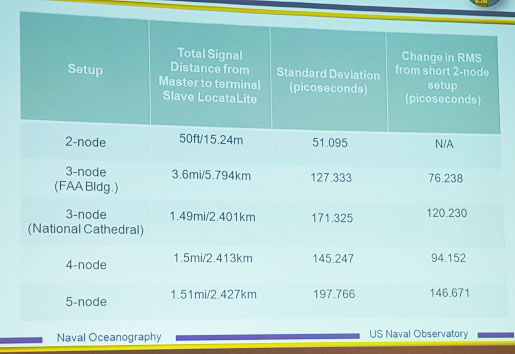
Pico-second test results (Click on the image to enlarge it.)Pico-second test results
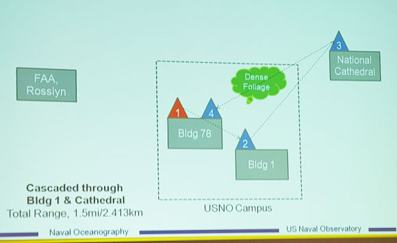
Later, I managed to catch a paper which Locata had recommended, which involved a number of Locata networks used by the U.S. Naval Observatory to demonstrate time and frequency transfer using the USNO Time Standard, with some highly accurate results: picoseconds! This paper forms the basis of GPS World magazine’s October cover story, providing more on these significant time-transfer and synchronization findings.
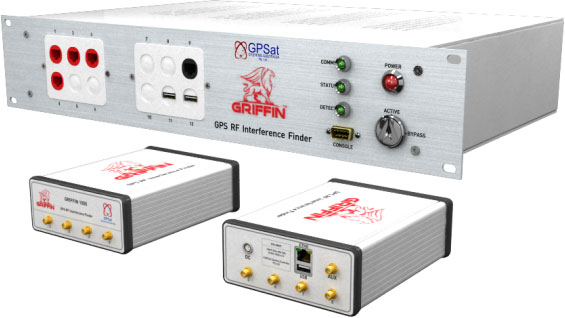
GRIFFIN Central Processor & Node Antenna Electronic Units
Another significant paper was presented in the Interference & Spectrum issues track. GPSat Systems Australia has been working for some time to implement a jammer/interference detection and localization system. The GRIFFIN 1000 system uses both Angle of Arrival (AoA) and Time Difference of Arrival (TDOA) to locate interference sources. GPSat claims that RF interference source in the GPS L1 band can be detected and geo-located to accuracies of a few meters within a few seconds. The system is already in production, with final production field testing underway, and customer deliveries scheduled for November.
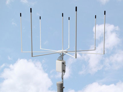
Multi Element Antenna Array and Node Electronics
As ION GNSS+ came to a close for another year, it appears that this GNSS-centric conference is weathering the industry’s apparent preference for other sector shows which may draw new paying customers. ION’s academic/technical content was top-notch as usual, unparalleled anywhere, with attendees flocking to the papers, while existing customers still found comfort in meeting their suppliers on the show floor and around the corridors of the Conference Center. The formula still seems to work for now, but the apparent feeling on the floor was that better exhibitor payback may be found elsewhere, and that this could reduce ION participants in future years. Hopefully not, since this was a very good week for everyone with whom I talked.
Broadcom Corporation has announced a new GNSS chip for Internet of Things (IoT) and wearable devices that simplifies integration of GNSS into low-cost products. The advanced chip enables devices such as fitness bands to deliver pinpoint location while consuming minimal power and in some cases can eliminate the need for a separate microcontroller (MCU).
The Broadcom BCM47748 removes a bulk of the signal processing from the device MCU by calculating position, velocity and time (PVT) on-chip, delivering significant system power savings. The chip uses intelligent firmware to extend battery life while also maintaining accuracy in speed, distance and position for an enhanced user experience.
Broadcom At ION GNSS+: Broadcom’s Stephen Mole is presenting on the topic of achieving low power consumption in wearables at ION GNSS+ 2015, taking place Sept. 14-18 at the Tampa Convention Center in Florida. Stephen will present during the A5 session, Applications using Consumer GNSS, on Friday, Sept. 18, at 9:40 a.m. inRoom 23.
“Broadcom is extending its navigation leadership into the IoT ecosystem by helping customers deliver a premium location experience without compromising battery life or requiring a costly, power-hungry host processor,” said Prasan Pai, Broadcom senior director, Wireless Connectivity. “With more consumers demanding GNSS in a wider variety of applications, we see a tremendous opportunity to expand our reach into new devices with market-leading GNSS technology.”
By absorbing location computations on-chip, Broadcom not only reduces power consumption but can also dramatically lower costs for original equipment manufacturers (OEMs) by replacing the device MCU and reducing board space. Additionally, firmware inside the BCM47748 automatically adapts to user activity and context, whether biking, walking or running, to provide precise location results to the user, enabling performance that is not sacrificed for power savings.
Key features:
PVT computed on-chip
Integrated GNSS receiver with concurrent support for GPS and GLONASS, combined with accelerometer inputs to produce stable, accurate and low power speed and distance
Context engine and adaptive firmware to enable low power consumption for every activity and context without compromising accuracy
Ability to produce GNSS fixes with only 5mA current consumption in certain scenarios
MCU host interfaces include SPI, UART or I2C
Sensor interfaces include I2C master, SPI master, I2S, ADC and GPIO
Large on-chip memory for enhanced PVT accuracy and customer applications
Embedded processor with self-boot capability
Geofencing and lifelogging capabilities
70 ball WLBGA package with 0.4mm ball pitch
The Broadcom BCM47748 is currently sampling with customers. Evaluation kits and reference designs are also available.
Unicore has released the UB380 GPS/GLONASSS/BDS high-precision board at ION GNSS+ 2015, held this week in Tampa, Fla.
UB380 is a multi-GNSS receiver that supports GPS, GLONASS and BDS. It is based on Unicore’s mature multi-GNSS system on chip (SoC). UB380 is designed for high-precision positioning, navigation and GBAS applications.
UB380 can track GPS L1, L2, L5; GLONASS L1, L2; and BDS B1,B2, B3 (support) — the support of GPS L2P, L2C can satisfy the high-precision requirements of GBAS reference station equipment.
With the latest tri-frequency RTK engine, UB380 can process tri-frequency of BDS and GPS, and the dual-frequency of GLONASS observation data, which can significantly reduce initialization time, improve position accuracy, and enhance reliability in difficult environments such as in urban canyons and under tree canopy, as well as make long baseline RTK possible.
The UR380 GNSS receiver with UB380 inside.
UB380 is compatible with industry-standard GNSS boards in size, interfaces and electrical standards.
Features of UB380:
384 channels, support for BDS B1/B2/B3 + GPS L1/L2/L5 + GLONASS L1/L2
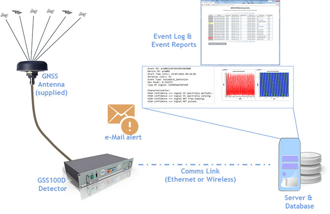
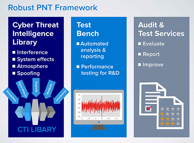
Spirent Communications has announced a Robust PNT Test Framework that evaluates GPS and GNSS security vulnerabilities for positioning, navigation and timing (PNT) systems.
Threats to GNSS and related PNT applications are more orchestrated and coordinated, with the motivation to disrupt or cause financial loss. The technology to disrupt GPS has also become much more accessible, resulting in GPS vulnerability gaining attention at hacker conventions.
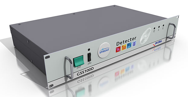
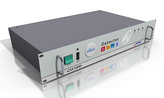
Spirent’s GSS100D Detector, developed in collaboration with Nottingham Scientific Ltd, enables detection, characterization and analysis of real GNSS threats.
The Robust PNT Test Framework will be used by technology, system and application developers where PNT is critical. Spirent’s framework enables threats to be detected in the field, taken into the lab and re-synthesized along with GPS and other GNSS signals. In addition, Spirent’s threat intelligence library of actual and typical threats provides a wide range of GNSS segment errors and spoofing attacks, as well as space weather and other vulnerabilities for preventive troubleshooting.
“Spirent wants to move beyond talking about the increase of GNSS vulnerabilities and offer a pragmatic approach to enable informed decision making when it comes to evaluating the impact of vulnerabilities,” said John Pottle, marketing director of Spirent’s Positioning Technology Division. “Through our Robust PNT Test Framework Spirent is pulling everything together to enable users to readily audit systems and take practical steps to improve resilience.”
 NVS Technologies AG has launched an L1 RTK+Heading GNSS receiver. The NV08C-RTK-A is fully integrated multi-constellation satellite navigation receiver with embedded RTK functionality and compatibility with GPS, GLONASS, Galileo and BeiDou.