The Sochi 2014 Olympic Winter Games mobile app, Wireless Olympic Works (WOW), turns the world’s Android devices into mobile sports stations that fans can use to personalize their own Olympic Winter Games experience, according to maker Samsung Electronics.
The XXII Olympic Winter Games, held in Sochi, Russia, run February 7-21.
Fans attending the Olympic Winter Games in Sochi will have access to a location-based Olympic Winter Games venue guide through the Samsung WOW technology. The guide offers Olympic venue information and navigation services so visitors can feel truly integrated into the Olympic Winter Games experience on the ground, Samsung said.
Samsung’s Public WOW app also provides sports fans with real-time access to event schedules, latest reports on results, medal standings and Olympic records. Public WOW is an extension of Samsung’s custom WOW for the Olympic Family, which is a wireless communications platform developed to ensure smarter communications and smoother, wireless operations of the Olympic Winter Games by offering news and information about the games to officials and staffs.
“Samsung is offering fans around the world the most direct access to Sochi 2014 Olympic Winter Games and allowing them to design and personalize their experience in ways that are most relevant to their interests and passions,” said WS Lee, senior vice president of New Business Development, Mobile Communications Division at Samsung Electronics. “Our dedicated teams are hard at work year-round to ensure that the WOW technology is ready for use throughout the Games, both for consumers looking for the ultimate Olympic Winter Games experience, and for the Olympic Family utilizing our technology to support Games-time operations.”
All Android users worldwide can download Samsung’s Public WOW app via the Samsung App store and Google Play.
Components of the Samsung WOW app allow fans to design their own Olympic Winter Games experience in the following ways:
Personalize an Olympic Winter Games updates plan. highly personalized, live Games-time updates ranging from medal counts to big moments that can be pushed to users’ phones in real time. A new cheering service will allow fans to send cheers to support their favorite athletes and countries.
Share celebrations with social network features. Users can upload text and images instantly to share with other WOW app users and with their social networks, creating a global community around shared interests in the Olympic Winter Games and winter sports. Languages supported for the Public WOW app include Chinese, English, French, German, Korean, Russian and Spanish.
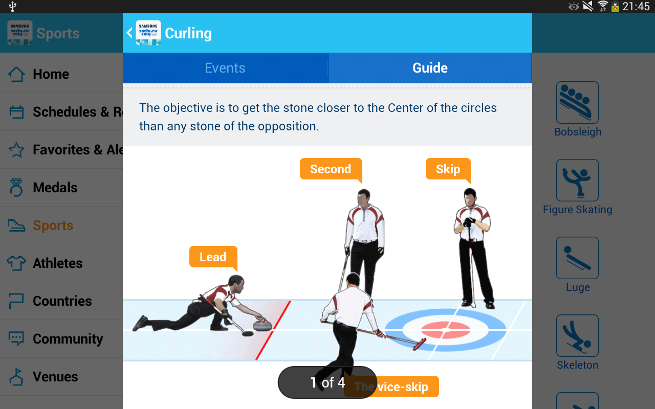
Learn about Olympic sports with an interactive, visual guide. The app offers information on all 15 winter sports at Sochi 2014 through a highly visual and engaging graphic user interface. A Visual Sports Guide will provide tutorials on each sport, including rules, equipment details and many other points of interest bring people closer to the excitement of the Olympic Winter Games.
“With its advanced technology in wireless communications, Samsung has played an essential role in the successful operation of the Olympic Winter Games. We believe the WOW app for Sochi 2014 will once again benefit the Games with more efficient and faster communications for the Olympic Family as well as fans around the world” said Timo Lumme, managing director, IOC TMS.
As part of the “Samsung Smart Olympic Games Initiative,” Samsung will provide around 18,000 mobile devices to the Olympic Family, including executives, staff, and officials from the IOC, National Olympic Committees and organizing committees in Sochi. They will be connected to Samsung’s WOW service which will provide essential, up-to-date Games Time data and connectivity that is crucial to the Olympic Winter Games operation.
The Samsung WOW service was first launched during the Athens 2004 Olympic Games for the Olympic Family and has since evolved into a must-have resource for officials, attendees and fans worldwide.
Samsung began its Olympic Games involvement as a local sponsor of the Seoul 1988 Olympic Games. Beginning with the Nagano 1998 Olympic Winter Games, the company extended its commitment to the Olympic Movement as the Worldwide Olympic Partner in the Wireless Communications Equipment category, providing its proprietary wireless communications platform, called Wireless Olympic Works (WOW), and mobile phones. These mobile phone technologies provide the Olympic Family with real-time, user location-based information service and interactive communications. Samsung’s commitment as a Worldwide Olympic Partner continues through to Rio 2016.
Telenav, Inc., announced today that it has acquired skobbler GmbH, the European-based navigation company with the highest rated OpenStreetMap (OSM)-based GPS navigation apps in the world. With this acquisition, Telenav brings the most successful OSM navigation experts in the world together as one team — including the founder of OSM, Steve Coast, who joined Telenav in 2013 — and becomes a major contributor to the creation of the open-sourced and most comprehensive map of the world, according to the announcement.
The acquisition closed on January 29 for consideration of approximately $19.2 million in cash and $4.6 million of company common stock.
“Crowdsourced OSM can power personalized navigation services like Scout — with highly detailed maps on a global scale,” said HP Jin, Telenav’s chairman and CEO. “We plan to offer Scout with OSM for much of the world. We have already made significant headway toward this goal in the U.S., including using OSM for our HTML5 version of Scout.”
OSM is the only crowdsourced and open-sourced map of the globe and, for many developers, it has become a clear alternative to Google Maps.
“Waze and Google — or, just Google now — provide similar mechanisms to improve their maps, based mostly on OSM’s innovations. With one big catch. It is very much their map. Not yours,” said Coast in his blog commentary today regarding the acquisition. “OpenStreetMap is different. All of the quality data contributed is openly available — just like Wikipedia. So, anyone can download, experiment and play with it freely. It’s not locked up beyond your reach.”
Since Coast founded OSM, the community has doubled year over year to more than 1.5 million registered editors, becoming a global community of local editors in every corner of the world. Its crowdsourced model publishes edits every minute on openstreetmap.org, resulting in maps that are detailed and up to date. For example, newly laid streets and newly developed areas can be updated on a regular basis and in real time. In addition, OSM allows for greater map detail for pedestrians such as alleys, sidewalks, parks, hiking trails, zoos, and even city trees.
Telenav has been an active contributor to OSM for more than three years, working closely with the community to enhance specific features needed for navigation, traffic and other future location-based services.
With offices in Germany and Romania, skobbler was the first company to launch a commercial navigation app using OSM (in 2010) for both Android and iOS devices and is available in app stores in 49 regions with worldwide map coverage. In order to do this, skobbler developed sophisticated algorithms that evolved OSM data from a display map to a navigable map.
skobbler’s apps are top ranked and highly rated in multiple countries including Germany, the Netherlands, and Sweden. skobbler’s CEO, Peter Scheufen, previously served as the CEO of Navigon, which became a leading GPS device manufacturer in Europe and was eventually purchased by Garmin. The other skobbler founders also held senior roles at Navigon before founding skobbler. Telenav expects that all skobbler employees will join Telenav as part of its OSM team, bringing significant industry-leading software expertise in location-based services, navigation and mapping.
“By joining our efforts with skobbler, we will build on our combined successes to bring the best mapping and navigation services to our customers around the world,” said Jin. “The benefits of an open source model will provide an enormous opportunity to change the economic models of navigation and other location-based services.”
“OSM is currently one of the most active and dynamic crowdsourcing communities and is growing at an explosive rate,” said Scheufen. “Our team lives and breathes OSM and so we are excited to join forces with Telenav to create the largest, most sophisticated, and smartest OSM navigation team in the world.”
In connection with the acquisition and in accordance with NASDAQ Marketplace Rule 5635(c), Telenav granted four employees of skobbler and its subsidiaries, upon the closing of the acquisition, restricted stock units for an aggregate of 634,920 shares of common stock.
These RSUs were granted outside of the existing Telenav stock plans and without stockholder approval pursuant to NASDAQ Marketplace Rule 5635(c)(4) with the following terms: each RSU vests as to 50% of the award on the anniversary of Acquisition and as to 50% of the award on the second anniversary of the Acquisition, subject to continued employment through each relevant date.
The new Mazda3 infotainment system, which appears in Mazda3’s Active Driving Display, is now running on NNG’s iGO navigation engine, and includes TTS, voice recognition and full 3D navigation.
This solution, supported by Mazda’s MZD Connect, is also reportedly the first on the market to offer an embedded connected-service package with Internet connection provided through the driver’s smartphone. Drivers will be able to access dynamic local search, fuel prices, real-time traffic and weather information free of charge in the first 60 days, and benefit from three years of free map updates.
“Mazda’s new design, KODO, has really inspired us to develop an integrated infotainment system, with knowledge and refined features matching the look and performance of the car,” said Péter Balogh, NNG. “We succeeded in offering cutting-edge solutions in the head unit, enhanced safety, usability and comfort to the driver.”
Hyundai Motor America has selected Verizon Enterprise Solutions to provide a range of connected services including safety, security, diagnostics and infotainment to Hyundai vehicles starting in 2014.
“We selected Verizon to provide the wireless network service for ‘Next-generation Blue Link’ because both customer opinion and various data sources indicate that Verizon provides the best solution to our customers for both coverage and quality,” said Woo-Young Kwak of Hyundai Motor Group.
Hyundai vehicles are distributed throughout the United States by Hyundai Motor America and are sold and serviced through more than 820 dealerships nationwide. According to Forrester Research, the number of vehicles shipped worldwide with embedded connectivity is expected to grow from 5.4 million in 2012 to 36 million in 2018.
“Our agreement with Hyundai expands our long-standing collaboration with a wide range of auto manufacturers throughout the industry to support network engineering, security, cloud solutions, telematics platform, and program management for millions of vehicles in the U.S. and around the world,” said Mark Bartolomeo of Verizon Enterprise Solutions. “We are thrilled to be working with Hyundai to help enhance the driving experience for their customers. It’s the breadth of our expertise combined with the depth of our technology that allows our clients to launch new services and initiatives faster.”
AT&T and Sabre, a global travel technology company, announced they will jointly explore solutions that could usher in a more personalized experience for travelers. The two companies are developing and testing solutions that will utilize AT&T’s newly enhanced Location Information Services (LIS) – Hybrid, which allows developers to build geo-aware mobile applications. The companies are exploring how device-based location information services can help airlines, airport retailers, and other travel-related companies deliver intelligent, predictive and personalized services throughout a traveler’s journey.
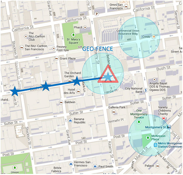
AT&T LIS Hybrid has the ability to define custom geofences (a virtual perimeter within a geographic area) in any shape or size, both indoors and out, using cellular, GPS and Wi-Fi information shared by the user from their devices. Knowing when a traveler enters or leaves a pre-defined geofence would allow travel suppliers to provide personalized services and relevant offers based on the traveler’s real-time location.
“By applying cutting-edge technologies, coupled with data analytics and better intelligence, we can give travelers the personalized experience they have come to expect in today’s connected world,” said Sarah Kennedy of Sabre Labs, the technology incubator and research lab at Sabre. “Together with AT&T, we will explore the role advanced location-based services can have in helping travel suppliers provide better, more personal service to their customers.”
The app might alert airline staff when a high-status passenger is still clearing security when her flight is due to depart; or notifies travelers of special promotions as they approach an airport bookstore; or warns a passenger if he is in the wrong terminal for his connecting flight. The two companies are exploring technology that could underpin these types of apps across almost all types of smartphones, tablets and operating systems. Any services developed as part of the trial will meet location services best practices guidelines when it comes to customer privacy including customer opt-in.
“Our application programming interface, or API, and software development kit allows companies like Sabre to build multi-carrier geo-aware mobile applications,” said Laura Merling, of AT&T. “AT&T LIS Hybrid works with Wi-Fi as well as existing cellular device-based information location services such as GPS, to deliver near-precise device location information indoors and outdoors.”
Phase one of the pilot project between Sabre and AT&T is expected to be completed during the first half of 2014.
skobbler has launched a new version of GPS Navigation optimized for iOS 7. The app now includes a travel guide, hyperlocal search, and mapping technology provided by skobbler’s NGx map engine.
Powered by data from the OpenStreetMap — a free and editable map of the world built by over 1 million voluntary contributors and map enthusiasts — GPS Navigation delivers true “hybrid” functionality, allowing users to switch between online or optional offline access through in-app purchases of downloadable maps, regardless of location or cellular connection, skobbler said.
Offline functionality allows for fast and reliable results using only a device’s GPS receiver rather than a network connection, meaning turn-by-turn navigation, alternate routing and various search capabilities are provided in full without a data connection.
GPS Navigation now features a comprehensive in-app travel guide and hyperlocal search via Wikitravel — which provides users with more than 90,000 pages of worldwide travel information in the English language alone — and TripAdvisor integrations.
Much like GPS Navigation’s online-offline mapping functionality, users can also access travel guide information with or without Internet connectivity, allowing access to the app’s travel features without roaming charges by opting for offline usage.
GPS Navigation is available for a one-time purchase of $0.99 via the iTunes App Store.
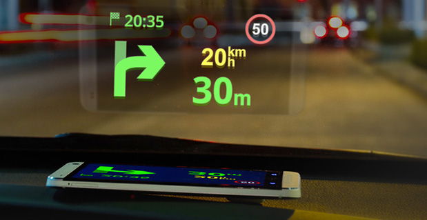
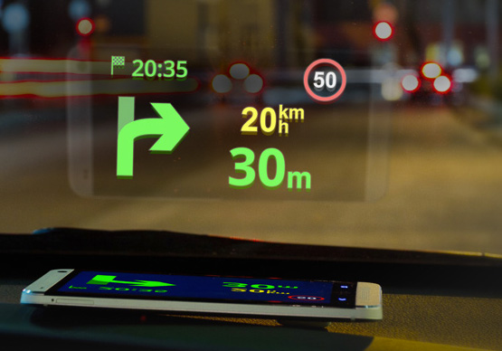
Sygic has announced a new product to make driving safer. Sygic’s Heads-up-Display (HUD) product projects navigation information onto drivers’ windshields, so they never have to take their eyes off the road to look down at their navigation software.
The product comes at a critical time for the holiday travel and shopping season, which is one of the most auto accident-heavy periods of the year. Sygic’s HUD is available as an in-app purchase for $4.99 and doesn’t need an expensive add-on product, as the projection can be emitted right from the Sygic GPS Navigation app on any iOS and Android phone or tablet.
Using Sygic’s HUD interface is straightforward. Drivers activate the feature from the app’s navigation menu, flip the screen via pop-up menu, and place their phone on their dashboard. The specially optimized interface will then
reflect clearly on the car’s windshield, displaying navigation information without the need for any expensive accessories. Sygic’s HUD feature gives them the full Sygic experience, complete with features like live traffic and turn-by-turn voice guidance.
“As we head into the heavy travel season, we hope our HUD will help drivers stay safe on the roads so they can spend more time with their family and friends and less time driving down heavily-trafficked and dangerous winter road conditions,” said Sygic CEO Michal Štencl.
Features of Sygic GPS Navigation include:
• Offline maps that don’t require a cellular data connection
• Turn-by-turn voice-guided GPS navigation
• 3D cities and landscapes
• Voice guidance in more than 40 languages
• Multi-stop routes and Drag & Drop route editing
• Speed limit display and audio warning
• SOS/Help to find assistance nearby
• Interactive map – tap on any street, POI, or photo to choose action
• Robust integration with third party
services like Groupon and TripAdvisor to find
things like deals, restaurants, hotels, attractions and more
• New speed cameras feature with a
constantly-updated database of stationary and mobile speed traps
Unlike other map services, data in Sygic: GPS
Navigation is stored on the user’s phone instead
of streamed from the Internet, which means that
Sygic users don’t have to worry about running up
against their cellular data caps by using GPS
navigation or getting lost in an area with poor
cell reception. When Sygic’s users are online,
they now have access to other helpful features
like real-time traffic and road incident sharing with other drivers.
Sygic GPS Navigation, now upgraded to version
13.3, is available in the iOS App Store and
Google Play, while the HUD feature can be
purchased from within the app for $4.99.
– See more at:
http://www.gisuser.com/content/view/31596/2/#sthash.goudUtyE.dpuf
Qualcomm Incorporated has announced that its subsidiary, Qualcomm Technologies, Inc., is enhancing location precision in smartphones and tablets initially in China with support for China’s BeiDou Satellite Navigation System.
Supporting the BeiDou constellation within Qualcomm IZat location solutions increases the number of satellites that Qualcomm-based devices can access to provide greater position location accuracy. Qualcomm is collaborating with Samsung to launch the first wave of BeiDou enhanced consumer smartphones, demonstrating the commitment of the companies to provide technology that delivers optimum performance for location-based services within China and globally.
Powered by the Qualcomm Snapdragon 800 processor (MSM8974), the Samsung Galaxy Note 3 (WCDMA 3G version SM-N9006 & TD-LTE 4G version SM-N9008V) uses the industry’s first, integrated tri-band location platform to provide more accurate and responsive location data to mobile users. It does so by concurrently processing signals from multiple satellite networks. Armed with this capability, users will have more enjoyable experiences using their location-based services, even in the most challenging of environments.
Leveraging Qualcomm IZat location solutions, Samsung will be able to deliver an optimal user experience with quick and accurate location information and services in China. Historically, this has been a challenge in some locations, especially in urban canyons, where devices may suffer from low visibility to satellites blocked by tall buildings that obstruct the signals. Bringing BeiDou-enabled phones to China means the Galaxy Note 3 has access to more satellites, which increases location accuracy. This ultimately improves customers’ pedestrian navigation, speeds local searches and enhances other location-based services.
Qualcomm’s mobile chipsets feature interoperability with existing constellations, which use tri-band hardware integration to deliver improved location capabilities in an optimal way, with enhanced accuracy, and with no additional increase in power consumption. In Snapdragon and Gobi™ chipsets, global positioning support is built into the modem and RF chips, enabling the location signals to be processed in the modem, instead of waking up the apps processor, thus saving power without sacrificing location accuracy.
“This industry-first implementation of BeiDou in a smartphone underscores Qualcomm’s leadership in the location industry. More than 3 billion devices which feature Qualcomm’s location technology have shipped to date and the introduction of BeiDou is the latest step to evolve our technology,” said Amir Faintuch, president, Qualcomm Atheros. “We see BeiDou’s support being an important factor for OEMs in China, and globally as well. With this new location enhancement, we believe our customers can bring greater differentiation with advanced performance, applications and services.”
Sonata is a self-service advertising platform for the retail world.
Currently, 96 percent of world trade takes place through traditional brick and mortar stores. Add almost 1,000 million smartphones with integrated GPS to that retailing picture and a whole range of advertising opportunities, with high added value for advertisers and consumers, opens up. Sonata was begun l to drive foot traffic to local retailers’ point of sale via potential customers’ smartphones.
Sonata divides the world into 90-square-metre plots. The plots are uploaded with local business adverts, which then appear on smartphones and tablets that come in range of the advertiser according to the smartphone’s geolocation. Sonata has been developed by TAPTAP Networks, a Spanish mobile advertising market leader based in Madrid.
The process of uploading an advertising campaign is very simple for the retailer and takes no more than three minutes, according to Sonata. A retailer doesn’t need a website or even a mobile app; all that’s required is a minimum investment of £50. Advertisers follow three steps:
registration using an email address;
adding the store details (just one or a whole network);
choosing the ad’s geographical area and the design of the ad from one of Sonata’s creative templates (or advertisers can create their own design).
“Any local business, including those without technical know-how, can create an advertising campaign,” says Alvaro del Castillo, CEO of TAPTAP Networks and the developers of Sonata.
“An added attraction of Sonata is that local businesses only pay for actual results-calls, registrations, clicks, purchases in the store… whatever form of contact a customer makes-and can choose how much to pay for them,” says del Castillo.
“The Sonata platform is focused on meeting the need of the local small-business sector, which views the online world as a major threat with the ever-growing pressure it exerts from ‘showrooming’ and the selling of cost price goods by major e-commerce players,” explained de Castillo.
Kipo, a GPS mobile location technology company targeting businesses and families, and Tigo Business Guatemala, a telecommunications company, announced their partnership to launch Localizador Tigo. Localizador Tigo is a smart, user-friendly location platform that allows any type of mobile device to connect to the web and trigger actions by predetermined rules, the companies said.
Triggers include location (arrival, exit, stay) and device events such as battery consumption and speed. Rules determine how the event will trigger and the action to take — send an email, post on social networks, mark a calendar, send an SMS, among others. For example, a company can create a rule that notifies a manager when his messenger delivers paperwork. Every time the messenger arrives to a specific location, the manager would receive an automatic email from the software. The sales manager could also create a rule to identify every time the sales team members have less than 10 percent battery. Once a device runs low on battery the manager would receive an automatic SMS to his mobile device.
The technology also lets team members check in and leave comments when they arrive with clients, information that can be seen in real-time on the web alongside a complete suite of reports to make cell phone devices more useful than ever before. The product can work with any mobile device — smartphones will be able to access the service through native applications and feature phones will rely on cell-towers to report location.
Localizador Tigo gives customers full ownership and control over their data and eliminating contracts, giving them the liberty to cancel service at any time. The product will be launched initially for corporate clients of Tigo Business and will be offered to individual customers on a later phase.
“We believe GPS location technology should be smarter and easier to use. This alliance with Tigo Business makes real-time GPS technology accessible to millions of Tigo customers, which is great because we are allowing more people than ever before receive the benefits this technology provides,” said Rodrigo Blanco, founder and co-CEO of Kipo, Inc.
“In Tigo Business we are always looking to provide our clients with the best and the most advanced tools so they can operate efficiently. We had been searching globally for the leading geolocation platform to incorporate to our mobile devices, and to our surprise we found it in a Guatemalan startup. The Kipo platform is functional, targets the needs of Tigo Business clients and is easy to use. The partnership with Kipo is a perfect next step to continue innovating and offering preeminent products to our clients,” said Hector Jimenez, category manager of Tigo Business Guatemala.
By Miguel Torroja, Steve Malkos, and Christophe Verne
Users of smartphones, tablets, and other devices expect position with the highest level of accuracy, always available, with the least amount of power consumed. One recent improvement fulfilling this demand involves operating-system services for location on smartphones, and the evolution towards lower power solutions.
“Please connect to a charger — The battery is getting low: less than 15 percent remaining.”
Handsets are battery-supplied devices, and a user’s tolerance for features is driven by battery consumption. There are many examples of technologies where users do not run certain hardware or features because it will consume the battery and make the phone useless within a short period of time.
The application processor (AP) of a handset device is very powerful, and is the part that consumes most of the battery life. Today’s smartphone multicore application processor is faster than many desktop computers that are just a few years old. Whatever the application, when it uses the AP, it can draw up to hundreds of milliamperes (mAs).
For the last few years, the trend for GNSS has been host-based positioning. Host-based designs have less logic on the GNSS integrated circuit (IC) and employ the host AP for a portion of the positioning computation. This strategy has three advantages:
Shares memory and code resources with the application processor.
Reduces the cost of the dedicated GNSS hardware.
Sharing the processor makes sense since it is already running.
Traditionally, when the GNSS solution was running, a navigation application that utilized the AP was also running.
However, when we only want to compute GNSS positions in the background, and we do not need a third-party application running on the AP, a host-based IC architecture is not the optimal solution with regard to system power consumption. This article explains some of the technologies used to compute a GNSS position using an ultra-low power (ULP) hybrid solution that combines the classic host-based GNSS architecture with a host-offload architecture that minimizes the use of the AP.
We discuss here two applications that benefit from a host-offload architecture: geofencing and position batching.
We will review the requirements for a platform to support a new hybrid GNSS positioning solution. Different host-offload technologies for geofence, such as GNSS, Wi-Fi, and Cell-ID, will be compared. Broadcom’s ultralow-power host-offload GNSS solution supports any operating system. We focus here on Android’s operating system because it is the most open OS.
Always-on Applications
Geofencing is an application that sends reports or triggers alarms when a predefined area is crossed. For example, users can be alerted to discounts with e-coupons when walking through a mall, or to “don’t forget the milk” — users can set their own reminder notifications based off of location; also, social networking. One example of location-based reminders is through Google Keep, which uses Android’s Geofence APIs on platforms that support hardware geofencing; this application will automatically take advantage of the hardware geofence solution.
Geofencing applications run in the background for long periods of time, and their main task is to compute positions (fixes) without the need of assistance from other applications. An ultra-low-power GNSS position solution, or always-on positioning solution, is desirable for these scenarios. Typical applications require notifications when entering or exiting a geofence area, or require periodic reporting of user positions relative to the fence.
Geofencing is not something new. API support has been provided in mobile OS for many years, but only now can it be used without draining the battery, thanks to this new host-offload architecture.
Figure 1 shows a circular geofence boundary and an alarm. In that example, the alarm was triggered when entering the fence.
Figure 1. Alarm when the vehicle enters a geofence area.
Breadcrumbing or position batching pertains to storing of positions, referred to as crumbs, which are accumulated for a certain amount of time and then pushed all at once to the application. Examples would be fleet or asset tracking applications, or people that wants to track their position while they are running.
Currently, Android does not support breadcrumbing as a native feature. There is some ongoing work, and APIs are being defined.
GNSS Positioning Models
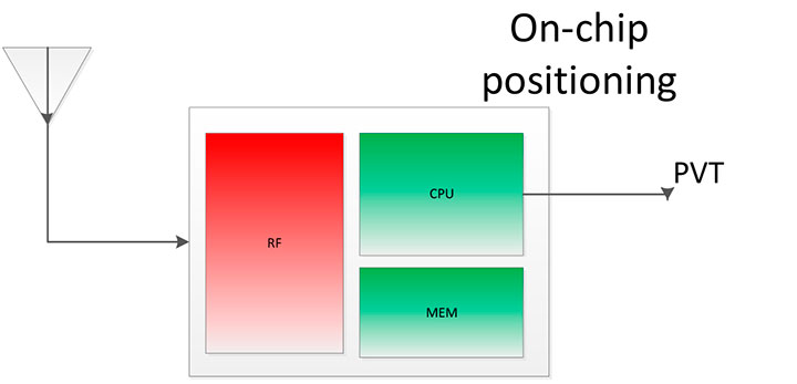
Before smartphones, the dominant GNSS hardware architecture employed a system-on-chip solution. The position/velocity/time (PVT) comes directly from the hardware, and all the computations are done in the GNSS IC.
On-Chip Positioning requires two things: a powerful-enough central processing unit (CPU) and lots of memory. The increase in CPU and memory performance are not free; they translate directly into more power and higher manufacturing costs.
The RF block in Figure 2 is intentionally drawn with a similar size to the CPU and memory, to emphasize the need for higher resources for a complete on-chip solution.
Figure 2. On-chip solution.
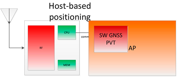
Host-Based Solution. GNSS positioning requires dedicated hardware, complex software, and protocols. This complexity led GNSS providers to move parts of the software out of the IC to the AP.
Using a mobile phone’s AP for position computation is one method of reducing the CPU and memory power footprint from the GNSS IC. At the same time, it also increases the power consumed by the platform needed to compute GNSS position, since part of the computation is not performed on the host-based IC. APs may consume approximately 100 mA just to be operational.
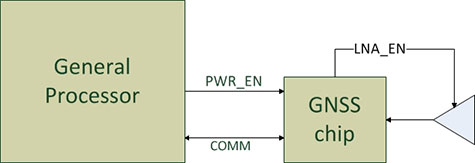
Figure 3 shows a typical configuration with dedicated GNSS hardware and a generic AP. In host-based mode, both the AP and the GNSS IC run in parallel when computing positions. The AP controls the GNSS hardware.
Figure 3. I/O connections in on-host positioning.
With this type of shared architecture, shown in Figure 4, the CPU and the memory on the GNSS IC are reduced, shrinking the size of the chip and reducing power consumed by the chip. In Figure 4 we see that the AP is communicating with the dedicated hardware, and the final PVT is computed by the AP. This solution fits well in many applications, such as navigation, where the AP has to run a mapping application at the same time.
Figure 4. Host-based solution.
Hybrid Positioning. For geofencing, we need a hybrid model, one which keeps GNSS IC complexity similar to the host-based architecture, but also offloads some of the host-based positioning so that the host can go to sleep.
In Broadcom’s hybrid mode, the AP does not need to run when GNSS positions are computed. Broadcom’s hybrid IC does not invoke the host AP often, and thus achieves an even lower power footprint. The CPU on the GNSS IC used for computing position is a dedicated one. It needs to be carefully chosen because it has to be powerful enough to compute positions and be as power efficient as possible. All this is done while keeping the GNSS IC area size in mind, to control cost.
Detailed analysis and steps were considered to ascertain the minimum requirements for the CPU and other resources to best accomplish the on-chip positioning task.
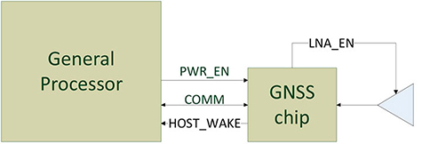
Other considerations: the GNSS IC must be powered even when the AP is suspended, and the GNSS IC must be capable of waking up the AP. Figure 5 shows a possible implementation using a dedicated I/O signal controlled by the IC to wake up the host AP.
Figure 5. I/O connections in hybrid positioning.
With this architecture, the host AP will still be needed to provide some assistance data to the GNSS IC. The assistance provided allows the GNSS IC to not invoke the host AP often and thus achieve an even lower power footprint.
Geofencing Methods
Certain OS application APIs have been supporting geofencing for many years. Currently, we can find geofencing APIs in most of the mobile OSs in the market.
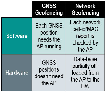
There are four main types of geofencing: GNSS software geofencing, GNSS hardware geofencing, network software geofencing, and network hardware geofencing (Table 1).
Table 1. Geofencing methods.
GNSS Hardware Geofencing. In this method, the one described in detail in this article, the OS initiates a request and offloads the areas of interest to the hardware. After that, the AP can go to sleep and the hardware is responsible for computing positions and checking the areas of interest. This method basically relies on GNSS hardware to compute positions and check the programmed fences.
GNSS Software Geofencing. Here, the OS initiates regular fixes to a host-based GNSS IC design. Then it invokes both the AP and the GNSS IC at the same time to check against the defined fence areas.
Network Geofencing. In this method, the OS requests network IDs from the hardware (that is, baseband modem Cell-ID and Wi-Fi access points). The OS uses different positioning technologies to compute position. This usually requires a connection to a server to retrieve location information about the different IDs. The position is used to check the geofences.
In network hardware geofencing, a set of network IDs is offloaded from the OS to the network hardware ICs. The hardware can poll for these IDs, and wake up the host when found.
Network versus GNSS Geofencing
A good geofencing solution combines both network and GNSS methods because each solution benefits from each other.
GNSS positioning solutions compute positions in open-sky environments with accuracy to a few meters and have worldwide coverage. However, they cannot work in deep indoor spaces.
Network geofencing using cell IDs is quite inaccurate, but works very well indoors. Network geofencing using a Wi-Fi access point provides reasonable accuracy, but location of the access points is not always known and it does not have full coverage.
Geofencing in Android 4.3. The API for applications supports geofencing. Starting from the first version of Android, the application just initiates a proximity alarm and will get an event when its boundaries are crossed. The OS is responsible for notifying the application when such an event occurs, and can use any technologies it sees fit.
The API that applications use is very simple. The monitoring is handled by the OS and is hidden to the application (for example, technologies, periodicity of checks, and accuracies).
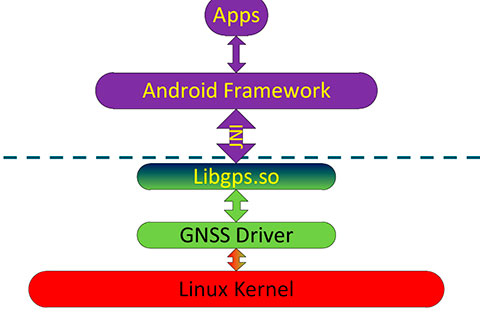
Software Geofence in Android. Software geofencing has been the default method until recently, as there was no native hardware support. In this mode, the host-based GNSS positioning engine is started like any other position request. The Android framework is the one dealing with the monitoring of the geofences, and therefore, the AP must run continuously to handle periodic position checks. That means the software-geofencing logic is mainly in the framework layer of Android (see basic layers diagram shown in Figure 6).
Figure 6. Android framework.
More recent versions of Android dropped the support for software-based geofencing in favor of a host-based GNSS system, likely because of the big impact on the battery. Broadcom developed a low-power GNSS hardware solution for geofencing.
Hardware Geofence in Android. Starting from Android 4.3, a new interface is available to use hardware geofencing. This interface is not visible to the application, and it is only used as a low-level interface. To support the new hardware-geofence interface, the native driver only has to register to a new GNSS interface defined in the native hardware abstraction layer (HAL) of Android.
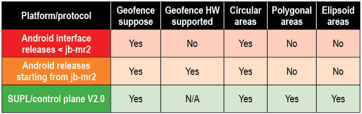
There are other protocols known to support geofencing. Table 2 provides a short list.
Table 2. Geofencing support on different platforms.
Broadcom Hybrid Positioning
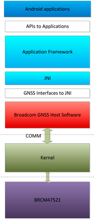
Android defines interfaces to the hardware, referred to as the HAL.
GNSS Host Software. GNSS providers need to comply to the HAL interface, which is at the Java native interface (JNI) level. Below the JNI lies the GNSS host software (Figure 7).
For the host-based solution, the GNSS host software handles most of the heavy computing.
For the hybrid solution, the GNSS host software does some of the heavy computing, but positions are computed inside the GNSS IC.
To support this new hybrid solution, two main changes are required compared to the usual host-based solution, as described below.
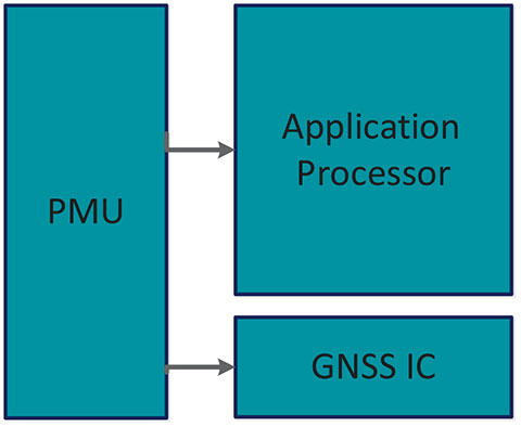
First, the hybrid GNSS IC must be autonomous while the host AP is sleeping. This implies that some power domains are maintained when the GNSS is in use. This typically means at least one of the outputs of the power management unit (PMU) should be dedicated to the GNSS only (Figure 8).
Figure 8. Power domains.
Second, the GNSS IC must be able to wake up the host AP so as to send geofence notifications, or to request assistance data. This is usually done through a dedicated pin.
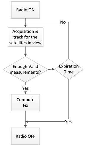
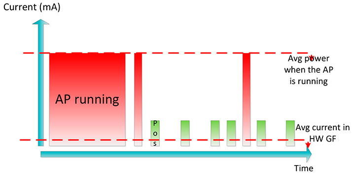
Acquisition and Sleep Period. Most of the power in the GNSS IC is used by the radio and analog part. To reduce power, this part is switched on only during acquisition. As soon as enough measurements are observed, the radio part is switched off while the digital part computes a fix.
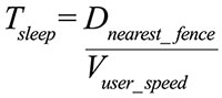
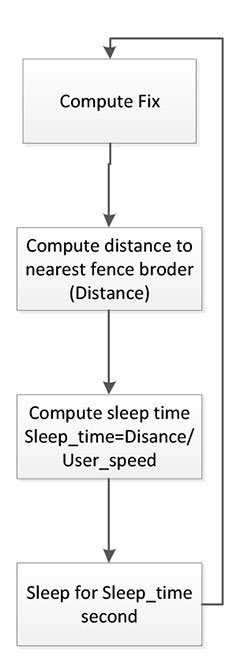
After each computed position, the GNSS IC can go into a deep power-saving mode until the next acquisition. The distance to the closest fence in conjunction with the user speed is used to determine when to compute the next position (Figure 9):
Figure 9. Start fix decision logic.
Once the GNSS IC starts computing positions, the AP can go into sleep mode (Figure 10). Total power per position computed is reduced, and the time between fixes is no longer constant, as shown in Figure 11.
Figure 10. Sleep time between fixes.Figure 11. Duty cycling.
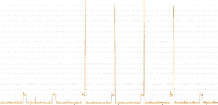
In Figure 12, the lower square-shaped pattern corresponds to a position computation from the hardware GNSS IC. Once we have an alarm, the host has to be woken up and we can see the impact in power in the big peaks after a position is computed.
Figure 12. Power graph.
Alarm Triggering
When a geofence area is crossed, the GNSS IC needs to wake up the AP. This is achieved using a dedicated interrupt pin. After asserting it, an alarm and geofence status is sent to the AP.
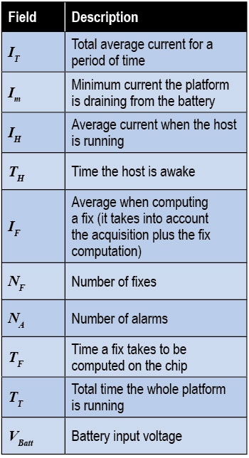
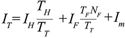
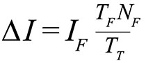
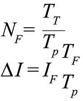
Power Consumption. We calculate the total average current by splitting it into three components, as shown in the following formula:
Some of these parameters are set by the host: for example, how often the fix should be computed. The extra current drained by the GNSS IC is the one defined by
∆I is the change in current drain when computing positions.
We can also express this formula based on the average number of position attempts:
where Tp is the average time between fixes (the time the GNSS IC stays in sleep).
Table 3 illustrates some theoretical ∆I current savings with respect to Tp.
Conclusion
As APs become faster and faster, their power consumption goes up. A novel hybrid GNSS receiver has been presented, which offloads some of the host-based processing into the GNSS hardware, offering ultra-low system power consumption versus the traditional methods. The new hybrid positioning solution is a good approach for always-on applications that need to have location information always available, without requiring the host to be running, as is the case with geofencing and breadcrumbing.
References
We would like to thank Jason Goldberg, Frank van Diggelen, and Manuel del Castillo, all of Broadcom, who reviewed this article and spent many hours with us discussing the topics point by point.
Miguel Torroja is a principal software developer at Broadcom. He has an M.Sc. in electrical engineering from Ramon Llull University, Barcelona. Since 2011, he has been working on the design and development of algorithms for optimizing power consumption in GNSS host-offload solutions.
Steve Malkos is a senior program manager at Broadcom. He has a B.S. in computer science from Purdue University. He has been active in the development of A-GNSS technologies such as hybrid location services, long-term predicted orbits (LTO), Broadcom’s worldwide reference network (WWRN), and secure user-plane location (SUPL). He has five patents issued and 16 pending.
Christophe Verne is a manager of software engineering at Broadcom. He has an M.S. in electrical engineering from Ecole Centrale, Paris. He has been involved in the development of GNSS and A-GNSS technologies at EADS, Sagem, Global Locate, and Broadcom, where he has been working on low-power host-offload positioning.
u‑blox and ARM, a semiconductor IP company, have joined forces to create a prototyping kit for designing wirelessly connected, location-aware Internet devices: the ARM mbed-enabled u‑blox C027 “Internet of Things (IoT) Starter Kit.”
“The Internet is reaching into every aspect of our lives, connecting everything from smartphones and tablets to devices for security, safety, surveillance, navigation, healthcare, convenience, and fun,” said Michael Amman, vice president of Platform Partnerships at u-blox. “To help engineers jump start their design of these types of Internet-connected devices, the C027 delivers out-of-the-box wireless Internet connectivity based on a compact u-blox 2G, 3G or CDMA cellular modem plus global positioning module. Together with the ARM Cortex-M3 32-bit processor and access to all the resources of the ARM mbed project, this is an extremely powerful and flexible prototyping tool.”
“This new kit will enable developers to join the ARM ecosystem and quickly move prototypes of intelligent ARM-based technology into production-ready designs,” said Charlene Marini, Vice President, Embedded Segment, ARM. “It brings together u-blox’s embedded cellular wireless and global positioning modules with the energy-efficient, high-performance ARM Cortex-M3 processor and the ARM mbed development platform. This exciting combination can drastically reduce the time required by manufacturers to build carrier-certified gateways, which will help to accelerate the Internet of Things.”
The compact C027 kit, measuring 54 x 98 millimeters, contains a u-blox “SARA” GSM or “LISA” UMTS/CDMA cellular modem, “MAX” GPS/GNSS positioning module, and an ARM 32-bit Cortex-M3 microcontroller with 512k of Flash Memory and 64kB RAM, user programmable via USB. CAN bus and Ethernet interfaces are provided. The board also provides direct connector with 22 GPIOs to access components via I2C, SPI, UART, and I2S digital audio. The C027 is an mbed-enabled board with Arduino-compatible connectors which can be easily stacked with additional expansion boards. A complete circuit diagram is provided with the kit.
To make development easier, the hardware is supported by the powerful and flexible open-source ARM mbed development platform, which provides free software libraries, hardware designs and online tools for professional and rapid prototyping of ARM-based designs. The platform gives access to a high-level standards-based C/C++ SDK for developing applications on the u-blox C027, a large component database of drivers for peripheral components that can be connected to it, and online compiler and developer tools for efficient reuse and collaboration on designs to create products quickly.