Broadcom Corporation today announced the industry’s first low-power GNSS and sensor hub combo chip to deliver new always-on location applications for a full range of mobile devices.
The Broadcom BCM4773 minimizes battery drain and adds a new layer of intelligence to location technology on mobile devices by integrating the GNSS chip and sensor hub into a single combo chip. Broadcom’s architecture enables information from Wi-Fi, Bluetooth Low Energy (BLE), GPS and micro electro-mechanical systems (MEMS) to be calculated on a single system-on-chip (SoC) instead of the application processor (AP). This design drives more than 80 percent power savings by offloading from the AP and lowers cost by reducing board area by 34 percent.
“Broadcom today extends its leadership by announcing the industry’s first combo chip that brings GNSS and sensor hub technology together to revolutionize mobile apps in areas such as health, fitness and lifelogging,” said Mohamed Awad, Broadcom director, Wireless Connectivity. “We are proud to make all mobile platforms even smarter by enabling them to dynamically predict and react to consumers’ needs.”
Additionally, Broadcom brings more intelligence to context awareness by integrating GNSS and providing a direct connection to the Wi-Fi combo chip. This allows a mobile device to know where a user is and what the user is doing to further personalize the experience. For example, a BCM4773-based smartphone can use information from Wi-Fi, BLE, GPS and MEMS to recognize when a runner is outdoors versus inside on a treadmill and dynamically manage these technologies to save battery life and optimize the user experience, all without involving the main AP.
Key Features:
Optimized for hardware offload of sensor fusion, on-chip positioning, geofencing and location batching
More than 80 percent power savings compared to standard GNSS receivers
34 percent board area reduction by integrating GNSS receiver and sensor hub
Standalone microcontroller offloads fusing of sensor data from the AP to maximize power savings
Concurrent support for five different satellite systems, including GPS, GLONASS, SBAS, QZSS and BeiDou
Ultra-low power on-chip positioning for background and foreground location using GNSS
On-chip Wi-Fi positioning using a direct connect communication protocol to the Wi-Fi SoC
Batching support for all devices connected to the Location Hub, including Wi-Fi, MEMS and GNSS
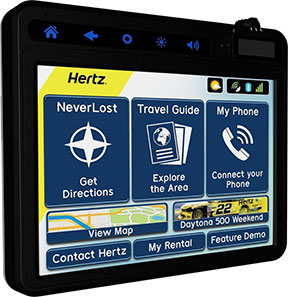
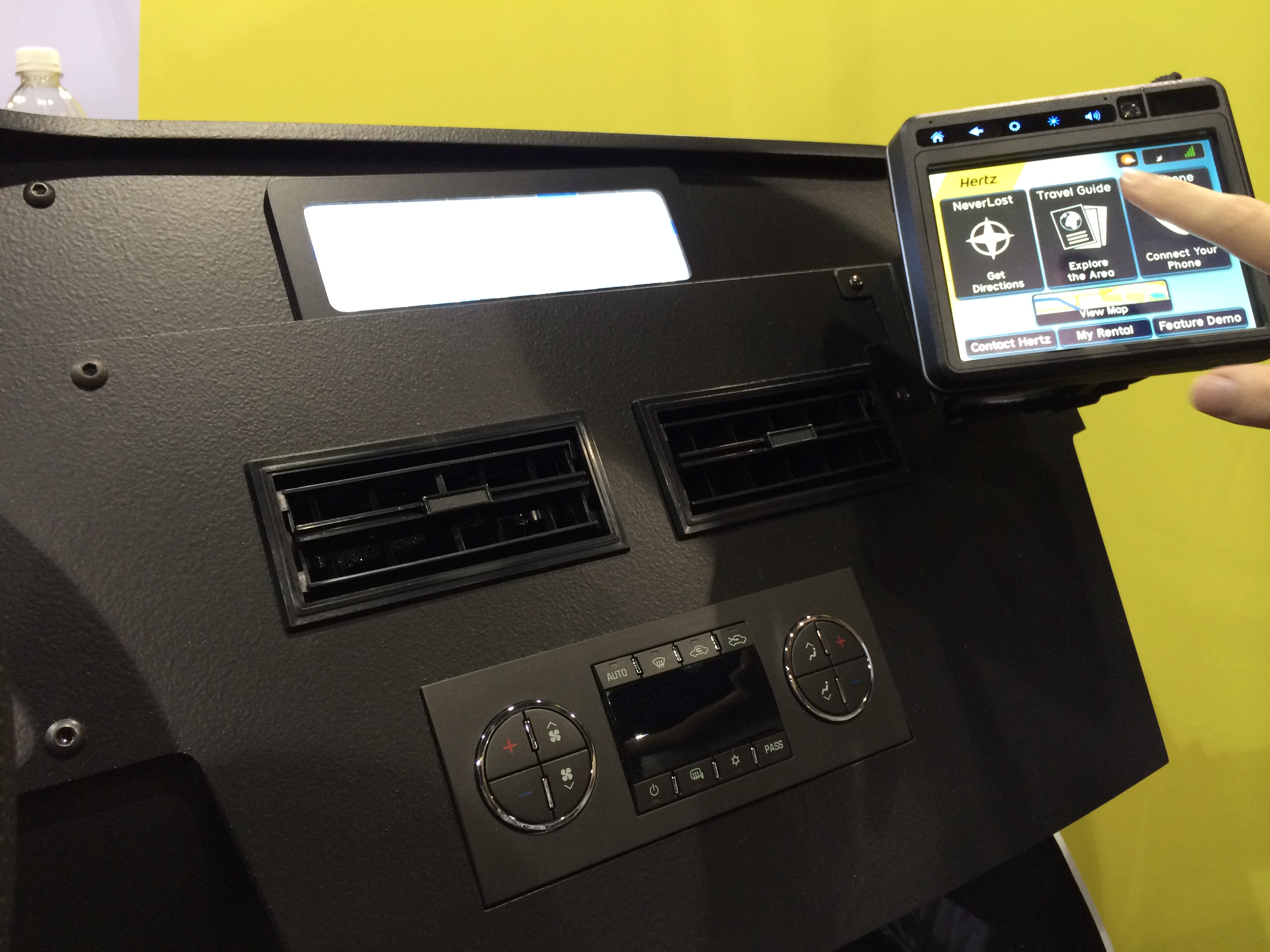
The award-winning in-vehicle system now offers more customization capabilities for travelers along with new navigation tools for convenience and personalization when planning trips. The new system syncs directly with the recently launched Hertz NeverLost Companion app, giving travelers access to more than 10 million U.S. destinations on their mobile devices to plan trips at their leisure, then instantly begin navigation in their Hertz rental.
“Our innovation goes beyond a typical navigation device, offering hands-free calls and instant Bluetooth connection, personal and customizable rental information, exploratory travel guides, weather, flight information, and even access to a concierge to provide the traveler with an enhanced rental experience,” said Mark P. Frissora, Hertz chairman and CEO. “With the latest Hertz NeverLost, customers can experience a new way of trip planning and navigation with a one-of-a-kind travel tool that allows them to see more, do more and discover more.”
Hertz NeverLost is available to rent along with a Hertz vehicle and offers groundbreaking features for rental GPS systems within the car rental industry, including:
Hands-Free Calls – For ease and safety on the road, pair with a smartphone to make and receive calls and access contacts. Phone numbers for points of interest within the device can also be dialed.
Travel Guide – Explore the city and discover local events. Quickly search through thousands of points of interest and get even more out of the trip with accompanying audio, images and descriptions.
Weather, Flights & More – Discover special events and local attractions and get access to weather and flight information.
NeverLost Concierge – Live concierge operators are available to help search for destinations, build custom trips and send route information directly to the NeverLost system.
Companion App – Stay connected with the NeverLost Companion app to sync favorites, explore the area and search for destinations from any location.
My Favorites – Enter download codes or use the USB flash drive to access trips built on NeverLost.com, the Companion app, or excursions built by the NeverLost Concierge team.
Contact Hertz – The device is programmed with all necessary Hertz phone numbers. And with hands-free calling, Hertz can be contacted with a paired smartphone with the press of a button.
Rental Record Info – View current rental record information on the device.
“We’re thrilled to be rolling out the newest version of Hertz NeverLost across the U.S. to offer travelers a sophisticated, yet easy-to-use navigation tool when renting with Hertz,” said Rob Moore, Hertz Chief Technology Officer. “With the instantaneous connection to our new Companion app, the NeverLost system has become a first-of-its-kind within the travel industry, shaping the wave of the future for navigation technology.”
Hertz NeverLost GPS navigation system, demonstrated at CTIA Super Mobility Week, now incorporates Bluetooth connection, hands-free calls, travel guides, weather, flight information and more.
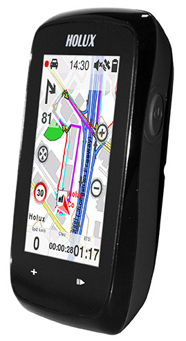
The Holux SporTrek 1305 for avid cyclists features a u-blox positioning module. Photo: Holux
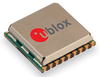
Holux Technology, a maker of professional and consumer GPS products, has launched its next-generation bike computer, the SporTrek 1305, which integrates a u-blox MAX GPS/GNSS module. The new device delivers GPS and wireless health-monitoring features on a compact, three-inch color touchscreen display.
The device delivers a variety of useful information such as speed, heart rate, distance, altitude, map, and route, and comes with a calendar and stopwatch. SporTrek 1305 is the designed for touring, competitive cycling and mountain biking.
The device integrates a compact u-blox MAX GPS/GNSS module that supports GPS as well as GLONASS, QZSS and all SBAS. The module is targeted at applications requiring small size, low power, fast acquisition, and reliable operation in GPS hostile environments.
“Since 1994, Holux has been manufacturing a wide range of battery-operated GPS products for sports, automotive and safety devices. We count on extremely fast, low-power and accurate global positioning technology to deliver the features our customers demand,” said Eddy Huang, director, Marketing & Sales at Holux. “u-blox’ advanced satellite positioning module provides us with the performance, small size, and low power consumption that we need in a consistent, future-proofed form factor.”
u-blox MAX GPS/GNSS module. Photo: Holux
The SportTrek 1305 is shock and water resistant able to operate in all weather conditions. Equipped with Bluetooth Smart for accessories (such as heart-rate straps), it can also connect to heart-rate monitor / combo (speed and cadence) sensors and smartphone connection and notification, providing navigation and performance training data.
It also integrates a patented “carbon reduction” feature that informs the user about the amount of equivalent carbon emissions saved compared to driving, and converts the data into the corresponding number of trees planted to achieve the same effect.
SporTrek 1305 can be integrated with ezTour Plus software to share track route and analysis of physical states, and it can also be used to plan routes using the ezTour Planner feature. Users can integrate their own paper maps and third-party application as well.
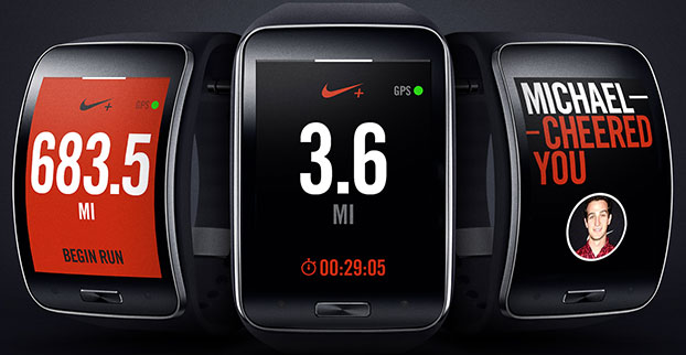
Samsung Electronics has unveiled its next-generation smart wearable device, the Samsung Gear S watch. The Gear S has assisted GPS+GLONASS, as well as 3G connectivity, allowing users to be active while always being able to access their smartphone information.
Designed with a two-inch curved Super AMOLED display and flexible band, the Samsung Gear S is also equipped with an accelerometer, a gyroscope, a compass, a heart rate monitor, and a barometer. The AMOLED display has an easy-to-use interface that allows users to read messages and notifications in a single glance with features such as conversation view and condensed font.
Connected to 3G networks, people can receive notifications from social networks, calendars and applications, even when away from their phones. Users can instantly receive incoming messages and easily reply to SMS using the onscreen keyboard or enhanced S voice functionality. The Samsung Gear S also lets users make and receive calls directly from their wrist as well as getting calls forwarded from a smartphone. The device lets users enjoy seamless communication by freely switching between connections, automatically connecting and synchronizing information once it is paired to a smartphone.
Samsung Gear S smart watch face detail. Photo: Samsung
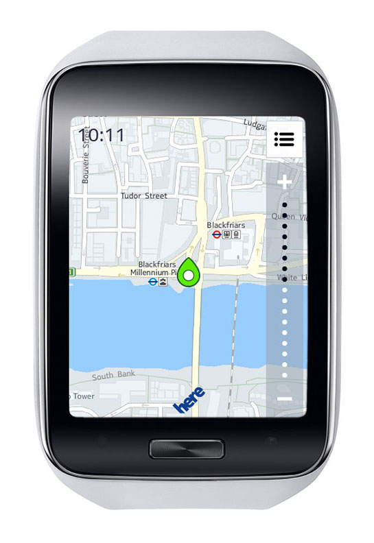
It also provides standalone features such as turn-by-turn pedestrian navigation provided by HERE. Health and fitness features include enhanced multi-sensors, built-in GPS, robust S Health features and applications like Nike+ Running so users can track their runs while leaving their smartphone at home.
“Samsung is leading the exciting and rapidly developing wearable category with continuous innovation that aims to enhance the lives of technology fans,” said Ines van Gennip, marketing director, IT & Mobile Division, Samsung UK & Ireland. “The Samsung Gear S is set to redefine the idea of the smart wearable device and the culture of mobile communication, enabling people to live a truly connected life anywhere, anytime.”
An Indian high-tech start-up is offering a GPS-enabled smart sports shoe that vibrates to give the wearer directions, according to an article in gulfnews.com.
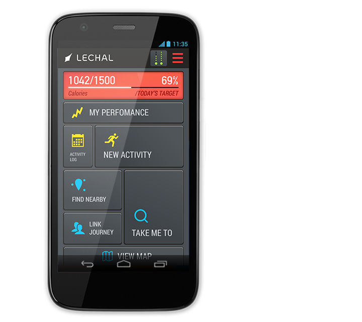
The red sneakers count the number of steps taken, the distance traveled, and calories burned. The shoes go on sale this month under the name LeChal, which means “take me along” in Hindi.
The shoes come with a detachable Bluetooth transceiver that links to a Lechal smartphone app to direct the wearer using Google Maps, sending a vibrating signal to indicate a left or right turn.
They are the brainchild of 30-year-old Krispian Lawrence and Anirudh Sharma, 28, two engineers who founded their tech start-up Ducere in a small apartment in 2011 and now employ 50 people. They say they have 25,000 advance orders for the shoes, which will retail at between $100 and $150.
The Lechal app works with Google Maps. Photo: Lechal
Advanced Search Engine Replaces Google Local Search in 122 Countries
deCarta, Inc., an independent LBS platform company, is now providing the local search function for a worldwide, top-five mobile handset manufacturer. deCarta has been hosting and running the search service since August 7 using its advanced geosearch engine — L2 — and has replaced the search service previously provided by Google. The service delivers millions of responses per day to this handset manufacturer’s local search and mapping application to users in 122 countries.
deCarta’s L2 is a high-performance, scalable local search engine with single line input and intuitive user interface. deCarta sources and indexes map and POI (points of interest) content from a wide variety of sources globally but also enables customers to easily index, control and search on their own content. The customer service announced utilizes TomTom map and POI content.
deCarta’s L2 can be used as a pure geocoder for address search, or for POI search, or simultaneously as a combination of the two mixed in a single-line search query — with the additional ability to tune this behavior at runtime. This gives developers maximum flexibility and creativity in producing their applications. deCarta recently expanded country coverage to enable its customers to offer global services.
The L2 Search engine is an integral component of deCarta’s LBS platform which provides specialized geospatial technologies for maps, routing, navigation, geocoding, local search and geo-data integration and processing. deCarta provides its white-label LBS platform to companies that wish to offer their own customized, branded LBS services as opposed to utilizing industry standard services such as Bing or Google.
deCarta has two deployment options for its platform: a hosted LBS Platform Service (PaaS) or, alternatively, customers can self-host either on-premise or in a cloud service such as Amazon’s AWS. Both approaches utilize deCarta’s REST API architecture and can scale to support billions of maps and searches and millions of users per month.
“We are quite happy with the market reaction to L2 since its introduction last year,” said J. Kim Fennell, CEO of deCarta. “We’re seeing large mobile, telematics and automotive customers switch to L2 in competition against other local search engines and geocoders such as Google, Bing, Nokia/Here and Pitney Bowes. Customers appreciate L2’s technology advantages, customization capabilities, flexible content offerings, less restrictive license terms and our superior customer service — all of which creates a more satisfied end customer experience.”
L2 enables deCarta’s customers to offer flexible, advanced local search capabilities that are on par with Google Maps but beyond other search engines. Examples include:
Single line entry of POI or address or both
Fast typeahead, predictive entry – ideal for mobile devices
High tolerance for misspellings and partial entries
Random ordering of address parameters
Search for a POI near a POI such as “ATMs near AMC Theater” or “Parking near SFO”
Search for POI near a specific address, i.e. “Parking near 1234 Main Street”
Furthermore, L2 can be integrated with deCarta’s patented “Search Along A Route” technology. This combined with the ability to index custom content and boost result rankings gives automotive OEMs and service providers the ability to offer more advanced and helpful “driver-centric” connected car services.
The Mobile Marketing Association (MMA), a global trade association for the mobile marketing industry, is forming a Mobile Location Data Accuracy Group. The focus of the group will be to eliminate any confusion around mobile location data and to improve the trust and confidence brand marketers and agencies have in mobile location advertising and the data that drives it.
Simultaneously, the MMA is forming a Location Leadership Council that will be an industry “think tank” comprised of a merging together of thought leaders from the MMA’s Location and Privacy committees and experts in the various areas of location — marketing, technology, data and policy. Stemming from the council will be a number of working groups, the first of which is the Mobile Location Data Accuracy Group.
The working group will expand on the previously launched Location Terminology Guide, in which the MMA Location Committee identified eight types of location data and signals, and ranked each according to the reach and accuracy of the data. The data and signals to be examined by the working group include (from most accurate to least):
Indoor positioning system
Bluetooth
GPS
Wi-Fi hotspots
Wi-Fi triangulation
Cell tower triangulation
IP address
User reported location
Specifically the Mobile Location Data Accuracy Group will:
Dig deeper into each of these data types and elaborate further on their appropriate uses and limitations.
Develop and issue an RFI (Request for Information) to all location data vendors and validators that will establish criteria with which vendors can be aligned with the data types they use.
Establish strict, standardized definitions with the MRC that vendors will be held accountable to and audited against.
According to an April 2014 BIA/Kelsey study on local media spending, location targeted mobile advertising accounted for 40% of the $7.22 billion mobile ad spend in 2013, and is expected to grow to 52% of the $30.3 billion forecasted for 2018.
“In order to scale mobile marketing specifically driven by location data, it is critical for the industry to come together to develop a common set of definitions of the types of location data available and how they are best used,” said Greg Stuart, CEO, MMA. “By agreeing to and abiding by a common set of best practices and guidelines, MMA members will be instrumental in driving the growth in the industry while assuring brand marketers of the measurable value derived from their mobile efforts.”
With tighter definitions of location data, and the viable uses of such data, measuring results will be more consistent and reliable, the MMA said. These benchmarks will allow buyers to have a much clearer understanding of the data being used, and how it will impact their location-driven mobile advertising campaigns.
Initial members of the group will include:
xAd – Monica Ho, SVP Marketing (co-chair)
Joule – Michael Lieberman, CEO (co-chair)
Factual – Vikas Gupta, Director of Marketing
ThinkNear – Brett Kohn, Director of Marketing
Mobiquity – James Meckley, CMO
Nielsen – Tom Eaton, VP, Client Services
MEC – Bav Panchal, Mobile
OpenX – Rob Kramer, GM, Mobile
Ubimo – Ran Ben-Yair, CEO
Verve – James Smith, CRO
“Having this type of transparency into location data is a huge step forward that will allow us, as buyers, to invest in mobile with increased confidence,” said Michael Lieberman, CEO, Joule North America. “This program will, in large part, allow mobile marketing to truly scale and deliver measurable results for our clients around the world.”
“We are committed to improving clarity and defining auditable standards for location data and ultimately all of location-based services. This will remove the barriers for brands and agencies to leverage the power of this unique mobile value proposition and improve their confidence in how and what to use,” said Monica Ho, SVP Marketing, xAd. “We are excited to work with the MMA and the industry in achieving standards that we believe will be critical for scaling the mobile marketing industry.”
The Mobile Location Data Accuracy Group will be gathering the industry leaders to share initial definitions and use cases at the Location Data Accuracy Panel Session August 26 at the Crowne Plaza Times Square, New York, 6:30-9 p.m. The session will provide an opportunity for brands, agencies and key partners in the location advertising arena to meet and discuss opportunities ahead.
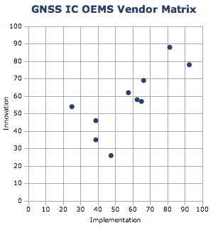
ABI Research’s 2014 GNSS IC vendor matrix names Qualcomm as the leading GPS integrated circuit (IC) vendor, followed by Broadcom in second place. For the first time, MediaTek achieves a top three finish after another year of strong growth and robust shipments as a result of its targeted design strategy, ABI Research revealed in its “GNSS IC OEMs” report.
The vendor matrix compares companies on 17 criteria across the broader categories of GNSS Innovation and Implementation. Qualcomm remains the dominant player with a strong ubiquitous location platform in IZat — this will be vital for success in high volume cellular handsets in 2015. It is also in a strong position to grow in other GNSS markets.
Broadcom continues to compete aggressively through innovation, receiving the highest score for this category for yet another year. Already in 2014, Broadcom has announced its concurrent tri-band BCM 47531 IC and the BCM 4771 GNSS SoC designed for wearables, featuring a sensor hub and always-on capabilities. Finally, it has also announced its 5G Wi-Fi SoC, which supports its new proprietary FTM-based AccuLocate technology.
u-blox has also moved up a position to fourth in this year’s assessment. It continues to grow revenue year-on-year, with little to suggest this will change in the coming year. It is also the first time u-blox has finished ahead of CSR, which was ranked fifth. CSR continues to transition and faces another arduous year in 2014. It will be 2015/16 when the effects of these tough decisions are proven out to be correct or not.
MediaTek has now emerged as a major threat, taking third on innovation and 2012 market share rankings, following very impressive shipments of its combo ICs into local Chinese smartphone manufacturers. It is also strong on PNDs/recreational and cameras, with a growing presence in other markets. Its move to fully embedded GPS in 2013 should prove significant in driving market share in the future.
Beyond this, STMicroelectronics also deserves a mention with its new Teseo III platform giving it significant design flexibility allowing it to compete aggressively in existing markets while expanding into new opportunities.
Tri-Band Multi-Constellation GNSS in Smartphones and Tablets
This article presents a single-chip BeiDou/Galileo/GLONASS/
GPS/QZSS/SBAS architecture for use in cell phones and tablets. The authors explain the advantages to end users of multiple constellations. They also examine the details of system interchangeability, multi-system issues, and how assisted-GNSS data operates with all constellations, including BeiDou.
By Frank van Diggelen and Kathy Tan
With GPS, GLONASS, SBAS, BeiDou, QZSS, and Galileo there are over eighty operational satellites. Why do we need all these satellites in the first place? The answer is simple: in urban environments we want a few (six to eight) good satellites with an unobstructed line-of-sight (LoS) to the receiver and good horizontal dilution of precision (HDOP). In order to achieve this, we need many more satellites in space than any single constellation. In this article, we address the following issues.
Receiver intersystem RF bias with a tri-band front-end. BeiDou uses a different RF section than GPS/Galileo/QZSS/SBAS and GLONASS. As a result, there is a receiver intersystem bias between BeiDou and each of these other systems—not just because BeiDou is on a different frequency, but because of the different RF path through the receiver. We explain how this bias is calibrated and removed.
In the space segment there are intersystem biases primarily caused by differences in time standards. We discuss time management and show how the different systems can be made interoperable.
BeiDou Assistance. In order to realize the benefits mentioned, we need infrastructure deployment for BeiDou assistance in accordance with 3GPP standards. We will discuss what is available, and what is left to do.
Coverage outside of China. Europeans can see more BeiDou satellites than Galileos. At the time of writing (March 2014) they could see approximately twice as many. Thus, when used in a multi-GNSS receiver, BeiDou is far from being just a regional system. We will provide coverage analysis, and live-test data, including a focus on Europe.
Finally, we will demonstrate all of the above in practice, explaining and showing how interchangeability is achieved, and where first fixes can be computed with no more than one of each satellite type.
Figure 1 illustrates the point referenced at the beginning, that we need many more satellites in space than any single constellation.
All of the lines in Figure 1 show signals that were actively tracked by the receiver at the position shown on the right. The orange lines are to satellites that are blocked, but the reflected signal is tracked. We do not want to use these measurements if we can help it, so we need many satellites to provide enough LoS signals.
Let’s look at the HDOP of the LoS signals. In this example, the HDOP for the three LoS GPS satellites was 50. For the three LoS GLONASS satellites, the HDOP was 45. However, with the combined GNSS constellation, the HDOP for the six LoS satellites was 2.2. In other words, we expect about a 20x accuracy improvement by using the combined constellation.
There are many places and times in cities where we see just one or two direct LoS signals from a particular constellation, and we need more than just GPS and GLONASS to get the desired number of good signals, thus explaining the desire and need for all available constellations.
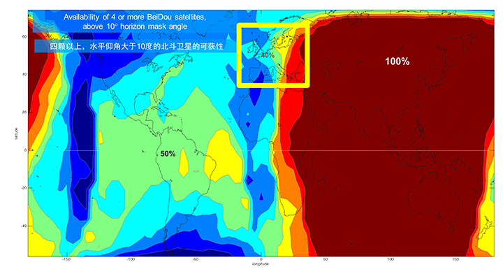
We’ll now look at the coverage provided by BeiDou2, which has five Geostationary satellites (GEOs), five inclined Geosynchronous satellites (GSOs), and four Medium Earth Orbit satellites (MEOs). With this 14-satellite constellation, the global coverage is as shown in Figure 2. This figure shows the percentage of time in a day that four or more BeiDou satellites are visible above a 10-degree mask angle. In the Asia-Pacific region, where the GEOs and GSOs are positioned, the coverage is predictably 100 percent. In fact, there are seven or eight BeiDou satellites visible in much of this region most of the time.
Figure 2. BeiDou2 global coverage.
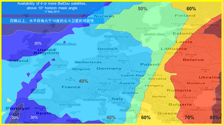
As shown in Figure 3, outside the Asia-Pacific region the coverage is also interesting. We see that at least four BeiDou satellites are available over Europe about half of the time. This is quite significant given the previous discussion; even one or two extra satellites can make all the difference in an urban environment. Another notable fact is that, for now at least, Europe can see more BeiDou than Galileo satellites.
Figure 3. BeiDou coverage over Europe. The different colors show the percent of time that four or more BeiDou satellites are visible above a 10° mask angle.
Technical Requirements
There are five significant technical requirements that we want to satisfy when creating a multi-GNSS receiver for consumer applications:
Three Separate RF Paths. To acquire and track all of the satellites already mentioned, we need three separate RF paths. Details follow in Section 3 (Front-End Architecture).
Search and Track capability for all visible GNSS satellites. The receiver must have the ability to search a very large number of code-frequency bins at once.
Host-Based. As much as possible, we want to make use of the host application processor (AP) and memory. This allows for tight integration with assistance data (which is coming from the host), other sensors, and other wireless data (such as Wi-Fi and Bluetooth for indoor locations). A host-based architecture also keeps size and cost as low as possible.
With Host-Offload. A significant trend in location applications is the need for “always-on low power” location. The host AP cannot be used for continuous position updates, since it draws too much power. So, while we want host-based location when the host AP is active (such as when navigating with turn-by-turn directions and a map), we also want a host-offload capability so that the GNSS chip can compute positions internally while the host is asleep.
Interchangeability. The ultimate requirement for multi-system GNSS is the ability to use any combinations of satellites as if they were all in the same constellation. This is summarized as “any four satellites will do.”
Front-End Architecture
From a cell phone/tablet perspective, the signals in space are all in the L1 band, with frequencies as shown in Figure 4. The key architecture feature of the GNSS front-end is that it should have three separate RF chains for the three separate frequencies-of-interest; see Figure 5.
Figure 4. Frequencies-of-interest for GNSS in cell phones.Figure 5. Front-end architecture showing three RF chains.
Baseband Architecture
The preferred architecture of a chip, as shown in Figure 6, is host-based to take advantage of the large host CPU when it is active. When the host CPU is asleep, a small, low-power, on-chip CPU is leveraged for background “always on” location. This enables applications such as geofencing to run without significantly reducing battery life.
Figure 6. Block diagram of the preferred architecture, showing a host-based configuration that includes a host-offload capability for geofencing and position caching on-chip when the host is asleep.
When the host is active, such as when you are actively using the phone for turn-by-turn navigation, the host AP is on and we want to make as much use as possible of the host AP and memory. This allows for tight integration with assistance data coming from the host, other sensors, and other wireless data (such as Wi-Fi and Bluetooth for indoor locations). A host-based architecture also keeps size and cost as low as possible, even with host-offload capability, which adds very little to the size of the chip.
Receiver Intersystem RF Biases
With the three different bands of frequencies, we will get RF group delays in the receiver front-end. These must be calibrated out by the receiver’s designer as part of the chip’s system design. If the group delay between BeiDou and GPS is not calibrated, it will lead to approximately three meters of bias between the two systems (Figure 7). Once it is calibrated, there is essentially no bias.
Figure 7. L1 frequency spectrum for BeiDou2, GPS, Galileo, QZSS, SBAS, and GLONASS.
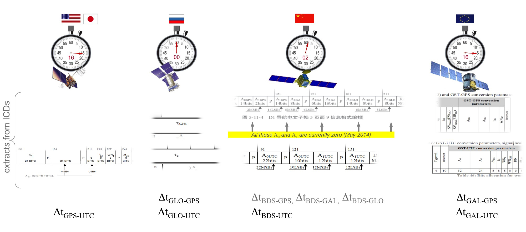
Satellite Intersystem Biases
Different GNSS constellations run off their own master clocks; referenced to different realizations of UTC. GPS is referenced to UTC (USNO), QZSS is referenced to UTC (NICT), GLONASS to UTC (SU), BeiDou to UTC (NTSC), and Galileo to UTC (INRIM). GLONASS UTC (SU) differs from the others by 3 hours.
Furthermore, different systems treat leap seconds differently. This is indicated by the red arrows in the clocks in FIGURE 8. GPS, QZSS, BeiDou and Galileo system times are continuous and ignore leap seconds. Thus, each system time is ahead of UTC by a number of leap seconds. GPS time started in 1980 in synch with UTC; there have been 16 leap seconds since, so now GPS is 16 seconds ahead of UTC. QZSS and Galileo system times were started in synch with GPS. BeiDou system time was started in 2006 in synch with UTC; there have been 2 leap seconds since, so now BeiDou is 2 seconds ahead of UTC. GLONASS system time, on the other hand, includes leap seconds.
Apart from this, each of the different realizations of UTC is within several nanoseconds of the others.
To combine measurements from these different systems and avoid any time-induced intersystem biases, we need to resolve the time offsets. Each system transmits the delta-time between its system time and the systems that preceded it, as listed in Figure 8. To combine the systems, we either need to decode these data messages or obtain the delta-time values from Assisted GNSS.
Figure 8. Intersystem time differences and broadcast delta-time values from each system.
Note, however, that in the BeiDou broadcast Nav message the intersystem time-offset data values are all set to zero (even though the true offsets are not zero).
Assisted-GNSS Including BeiDou
Assisted GNSS, or A-GNSS, increases sensitivity and decreases the time-to-first-fix of a receiver by providing assistance data in the form of the receiver’s approximate position, time and frequency, as well as all data that the receiver might decode from the broadcast signals. The assistance data may also include data beyond what is broadcast, in particular, let’s focus on BeiDou time offsets. The BeiDou time offset to the other systems is included in the BeiDou broadcast Nav message as shown in Figure 8; however, at present these data values are all set to zero (even though the true offsets are not zero). Thus, in order to get these offsets and integrate BeiDou properly into a combined GNSS system, one must compute the offsets at a reference station and provide them as part of the assistance data, as shown in Figure 9.
Figure 9. A-GNSS provides broadcast satellite data over some other wireless network, as well as time-offsets between the different pairs of systems.
Commercial Implementation
The preferred architecture described in this article has been implemented in a commercial GNSS receiver that is now available for commercial host-based products, such as cell phones and tablets. The chip, Broadcom’s BCM47531, is the first consumer GNSS chip with a tri-band front-end capable of acquiring and tracking satellites from GPS, SBAS, QZSS, GLONASS, and BeiDou constellations, simultaneously; and operating in host-based mode for navigation and in host-offload mode for Always-On location.
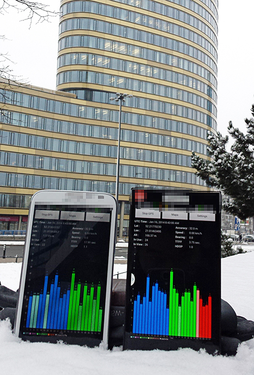
Broadcom has collaborated with leading smartphone manufacturers to launch the first wave of BeiDou enhanced consumer smartphones. Figure 10 shows one of these smartphones being tested in Europe. Note the number of BeiDou satellites in view. As predicted by the availability plots shown earlier, there are many BeiDou satellites in view (in this case, six).
Figure 10. GPS/GLONASS phone and GPS/GLONASS/BeiDou phone being tested in Warsaw, Poland. Note the six BeiDou satellites (red) that are seen and tracked by the BeiDou phone.
Interchangeability: Any Four
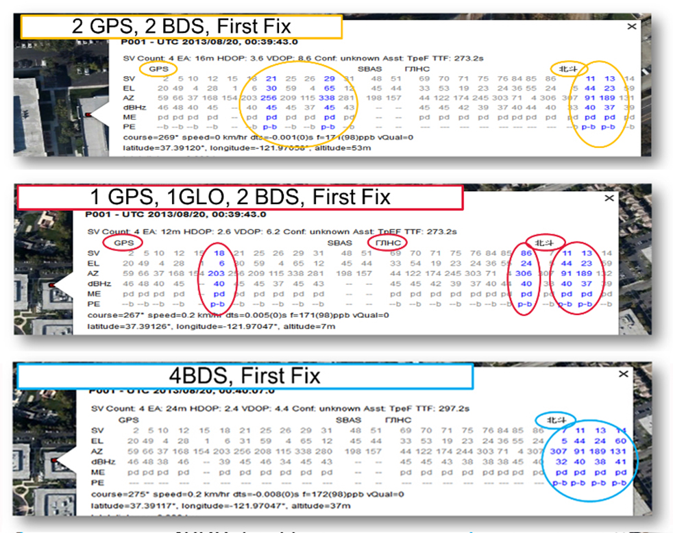
Now that we have addressed all of the major issues related to integrating different GNSS systems (in particular BeiDou), we can demonstrate the payoff.This is the achievement of interchangeability, where any GNSS satellites can be used together, as if they all belong to a single constellation. Figures 11 and 12 show assisted cold starts, where first fixes are obtained with no prior knowledge other than that provided by A-GNSS data. In each case, we show a different combination of satellites; including one satellite from each of four different constellations, and all four from BeiDou.
Figure 11. Interchangeability: Position fix with 1 GPS satellite, 1 GLONASS, 1 QZSS, and 1 BeiDou. The receiver is in Perth, Australia, where all of these constellations can be seen.Figure 12. Interchangeability: Assisted cold start, first fixes. Blue numbers show the satellites used in the position fix (top: two GPS and two BeiDou; middle: one GPS, one GLONASS, and two BeiDou; and bottom: four BeiDou only). The receiver is in San Jose, California, where four BeiDou satellites can be seen some of the time (some of the BeiDou GSOs can be seen and all the BeiDou MEOs can be seen for a few hours each day).
Multi-Constellation Robustness
While this article was being edited, the GLONASS system provided us with the most dramatic demonstration yet of the need for, and benefits of, multi-constellation receivers. On April 2, 2014, the GLONASS system failed spectacularly for a period of 11 hours. Receivers that used GPS and GLONASS had very large position errors, or no positions at all. While the receiver discussed in this article, the BCM47531, operated seamlessly. This receiver tracked GPS, GLONASS, QZSS and BeiDou satellites, correctly identified the faulty GLONASS satellites, and automatically stopped using them.
The details of the incident are as follows: The GLONASS control system uploaded incorrect orbit data to several satellites. When receivers used these satellites they had position errors of hundreds of meters, or no positions at all. At that time, the BCM47531 was being tested alongside a GPS/GLONASS receiver, and we have the data to show what happened. The receiver using only GPS/GLONASS suffered position errors of ten thousand meters, and long periods with no position at all; at the same time the multi-constellation receiver produced continual positions with normal accuracy. Figure 13 shows the test data — the left most image shows the route being driven, the middle image shows the data from the GPS/GLONASS receiver, and the right image shows the data from the BCM47531 multi-GNSS receiver. Figure 14 shows the details of the multi-GNSS receiver, you can see that no GLONASS satellites are being used.
FIGURE 13. Side-by-side tests of GPS/GLONASS receiver and multi-constellation receiver during the GLONASS incident of April 2, 2014. The GPS/GLONASS receiver produced errors of ten thousand meters and long periods with no position at all, while the multi-constellation BCM47531 operated seamlessly.FIGURE 14. Detail from the multi-constellation receiver when there is a problem with some satellites. The errors are recognized automatically by algorithms comparing the measurements to redundant measurements from the extra constellations, and the erroneous signals are not used.
This incident may raise the question: Why use GLONASS at all, why not just GPS? The answer is that in urban canyons, such as where this test was done, GPS alone does not have enough satellites to give the performance now expected in consumer products — for the reasons explained in the beginning of this article. Also, GPS, although it has been more reliable than GLONASS, is not immune to failures or jamming itself. The lesson of this incident is that reliability and accuracy comes from the combination of all the available constellations, with a receiver that can use the signals interchangeably.
Conclusion
We have shown the preferred architecture for a consumer GNSS receiver that includes all of the available constellations. We have addressed the major requirements of such a receiver for the consumer market, in particular, for cell phones and tablets. A receiver that meets these requirements is now available, the Broadcom BCM47531, has been designed into a new generation cell phones and tablets for 2014. Finally, we have shown how, with this receiver, the ultimate GNSS goal of interchangeability can be achieved.
Frank van Diggelen is vice president of technology at Broadcom Corporation, a consulting professor at Stanford University, and inventor of coarse-time GNSS navigation, co-inventor of Long Term Orbits for A-GNSS, and author of A-GPS: Assisted GPS, GNSS, and SBAS.
Kathy Tan is a senior principal engineer at Broadcom Corporation. She has worked on GNSS development and Assisted GNSS for Ashtech, Magellan, Global Locate and Broadcom. She received her MS and BS in electrical engineering from Fudan University, China.
McMurdo Group, an end-to-end search and rescue (SAR) and maritime domain awareness (MDA) company, has acquired Techno-Sciences, Inc. (TSi), a provider of SAR satellite ground stations, integrated emergency response center systems and coastal surveillance solutions. Terms of the acquisition were not disclosed. TSi’s Beltsville, Maryland, location becomes the U.S. headquarters for McMurdo Group, a division of Orolia, global specialist in critical GNSS solutions.
TSi has been instrumental in the development of the COSPAS-SARSAT international satellite-based SAR program, which has helped to save more than 35,000 lives worldwide since 1982. TSi is also actively involved in the next-generation COSPAS-SARSAT system, MEOSAR (Medium Earth Orbit Search and Rescue), which will greatly improve the existing SAR process with near-instantaneous detection, identification and location of emergency distress beacons.
MEOSAR, currently in its demonstration and evaluation phase, is expected to have initial operational capability in 2016 and full operational capability by 2018. MEOSAR will use SAR-enhanced Galileo (Europe), GPS (U.S.) and GLONASS (Russia) satellite constellations for greater global coverage and includes innovative end-user beacon functionality such as a return-link service on Galileo satellites to acknowledge distress signal receipt and provide ongoing rescue effort status.
“The acquisition of TSi firmly establishes McMurdo Group as the global leader in satellite-based search and rescue solutions. We are the only provider capable of supplying a single-vendor, end-to-end COSPAS-SARSAT emergency solution with a seamless ecosystem of products, technologies and processes that will streamline and expedite search and rescue efforts,” said Jean-Yves Courtois, CEO, McMurdo Group and its holding company Orolia Group. “TSi expands our global sales, support and customer footprint and adds to our already extensive expertise in SAR and MDA. We look forward to developing a U.S. SAR Center of Excellence to include manufacturing, distribution and support of McMurdo Group’s broad solution offering of distress beacons, AIS equipment, satellite communications units and emergency control centers equipped with search and rescue management software.”
TSi solutions are installed in more than 20 countries worldwide and include satellite ground stations or local user terminals (LUTs), rescue and mission control centers, and coastal surveillance/instruction detection systems. TSi installed the world’s first operationally ready six-channel MEOSAR LUT (MEOLUT) in 2011 for the U.S. National Oceanic and Atmospheric Administration (NOAA) and has recently completed a second NOAA installation (March 2014). With a team of 40 employees, TSi has a prominent list of government, military and commercial customers in Asia, Europe, Africa and the U.S. (including NOAA, NASA and the U.S. Navy).
Port Douglas, Queensland, Australia, is looking to reduce any potential deaths from falling coconuts, reports ABC News.
The Douglas shire council is mapping the GPS locations of its coconut trees, to reduce the danger. Mayor Julia Leu says more than 4,000 mature coconut palms have been identified in Port Douglas.
“All local governments that have coconut palms in their area do have a de-nutting program. However the de-nutting process is very costly,” Leu said. “What we want to do is look at this in a far more innovative way.”
On average, 150 people die annually around the world from falling coconuts.
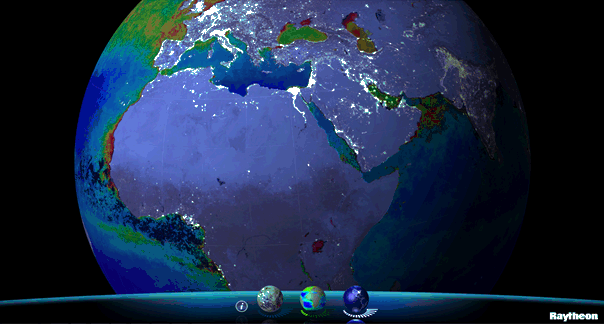
Available for iPhone, iPad and Android, VIIRS View provides mobile device users a look into the type of data meteorologists and climatologists use every day to track the weather and monitor Earth’s environment.
Based on data generated by the Visible Infrared Imaging Radiometer Suite aboard Suomi NPP, VIIRS View combines visible light imagery, low-light nighttime imagery and ocean chlorophyll concentration onto a full Earth globe, rotatable and zoomable on any location on the planet.
A desktop version of the VIIRS View app, launched in February, has been downloaded more than 90,000 times.
An original large format VIIRS View interactive tabletop display is being shown at Raytheon Booth #203 at the the 30th Space Symposium, being held this week in Colorado Springs, Colorado. GPS World Defense Editor Don Jewell is providing coverage from the symposium.
The app can be downloaded by searching VIIRS View at the Google Play and Android stores, or by clicking here: