Topcon Positioning Systems has become an authorized distributor of Pix4D’s photogrammetry software portfolio, expanding access to high-precision positioning and 3D mapping technologies.
The partnership aims to enhance reality capture solutions across various industries, including surveying, mapping, architecture engineering and construction, energy, utilities infrastructure, public safety, and forensics.
The agreement streamlines the procurement process for end-users by allowing them to access Pix4D‘s advanced photogrammetry software solutions through Topcon’s established global distribution network and ensures comprehensive technical support for users.
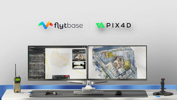
FlytBase and Pix4D have entered a strategic partnership, allowing FlytBase users to seamlessly upload their drone-captured data directly to the PIX4Dcloud online platform.
As automated UAV-docked operations become more prevalent, the volume and frequency of data collection have significantly increased. The partnership addresses this by offering users a way to conduct numerous daily missions and schedule them in advance from remote command centers.
Using FlytBase’s Pix4D Flink, users can now directly sync UAV-captured data from FlytBase to PIX4Dcloud, an online platform for aerial mapping, progress tracking and site documentation. PIX4Dcloud processes high-resolution images using photogrammetry algorithms, transforming them into accurate, georeferenced orthomosaics, 3D meshes, point clouds and elevation models. The platform can be used in construction monitoring, mapping and surveying applications.
In addition to the one-click integration, FlytBase offers the latest automation functionalities required for docked UAV operations, combined with flight safety and fleet management capabilities. It allows users to execute consistent UAV data collection operations while seamlessly integrating with beyond visual line of sight (BVLOS) hardware and software solutions, such as parachutes, detect-and-avoid systems, uncrewed traffic management and weather monitoring systems for safe operations.
Adhering to ISO 27001, SOC 2 Type II and GDPR standards, FlytBase ensures data protection through network firewalls and offers flexible deployment options to accommodate enterprise data privacy requirements.
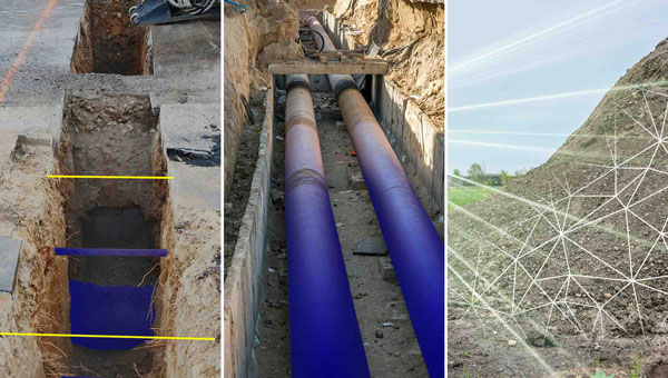
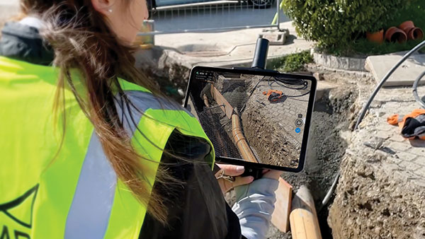
Emlid has launched the Pix4D & Emlid Scanning kit. The kit combines advanced photogrammetry with real-time kinematics (RTK) precision for quick data capture when documenting trenches and as-builts, performing volumetric measurements and enhancing aerial data with terrestrial scans. It includes the PIX4Dcatch app and the Emlid Reach RX RTK rover.
The PIX4Dcatch app is at the core of the kit’s software, which allows precise scanning for both photogrammetry and lidar projects. The hardware part features the Emlid Reach RX RTK rover, which is equipped with an ergonomic handle and accessories.
It is integrated with PIX4Dcatch and provides real-time positioning via NTRIP. To begin scanning, users can select Emlid in the RTK settings of PIX4Dcatch and add their NTRIP network credentials.
The kit works with any correction network (NTRIP) or a GNSS base station broadcasting RTCM3. The rover gets a fix in less than five seconds, offering centimeter-accurate positioning in challenging conditions. Apart from the scanning tasks, it can be used with the survey pole as an RTK rover for data collection and stakeout.
Designed for urban surveying, the Reach RX rover is lightweight, rated IP68, sealed and protected from water and dust and features an industrial-grade battery, which offers 16 hours of work on a three-hour charge.
The solution does not require additional setup or surveying skills. It is designed for professionals and non-surveyors in a range of applications, including underground utility documentation, construction inspection, volumetric measurements, crash reconstruction and combined aerial and terrestrial surveys.
The PIX4Dcatch mobile app allows users to use a smartphone for scanning, access RTK precision data through integration with Reach RX and generate a digital model within minutes. Users can also store, annotate, measure and share data online in PIX4Dcloud as well as verify geolocated positions and visualize the project in AR. It extracts insights from both terrestrial and aerial data and features online and offline processing, advanced photogrammetry capabilities, team collaboration and AR for CAD overlays.
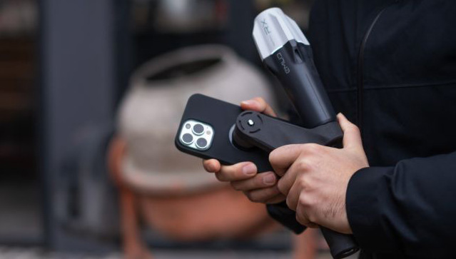
Pix4D is now offering a real-time kinematic (RTK) rover for use with iOS devices.
The Pix4D viDoc RTK handheld rover attaches to iOS devices to bring RTK accuracy to terrestrial scanning on iPhones and iPads.
When paired with the PIX4Dcatch mobile app, the viDoc rover can replace survey tools such as RTK GNSS rovers and terrestrial scanners, the company said.
Together, the products create a workflow that turns iPhones or iPads into an accurate terrestrial scanning device, with centimeter-accurate RTK positioning from an existing NTRIP network.
The tools can be used to 3D model small areas or structures.
Skyward, a Verizon company, has announced its integration with Pix4D, a photogrammetry software suite for drone mapping. The partnership gives customers the ability to turn drone data into 2D maps and 3D models.
Enterprises and drone pilots can now plan flights, receive FAA approval to fly in controlled airspace (LAANC), fly with Skyward’s InFlight ground control station, and process data using Pix4D from within the Skyward platform.
Skyward Mapping & Modeling, powered by Pix4D, enables customers to create, view, measure, and export 2D orthomosaic maps and 3D photogrammetric models right from Skyward’s web app. With the processing power of Pix4D, Skyward customers can get business-ready data sets through a seamless plan, fly, process workflow.
Skyward, a Verizon company, has announced its integration with Pix4D, a photogrammetry software suite for drone mapping. The partnership gives customers the ability to turn drone data into 2D maps and 3D models.
Enterprises and drone pilots can now plan flights, receive approval to fly in controlled airspace with LAANC, fly with Skyward’s InFlight ground control station, and process data using Pix4D — all from within the Skyward platform.
“Skyward has been bringing our customers tools to access airspace, plan and fly — now they can produce business-ready data deliverables without leaving Skyward,” said Mariah Scott, Skyward president. “Enterprises in construction, energy and utilities, and the public sector can get even more ROI out of their drone programs when combining Skyward’s drone management platform with Pix4D’s market-leading photogrammetry tools.”
Skyward Mapping & Modeling, powered by Pix4D, enables customers to create, view, measure, and export 2D orthomosaic maps and 3D photogrammetric models right from Skyward’s web app. With the processing power of Pix4D, Skyward customers can get business-ready data sets through a seamless plan, fly, process workflow.
“Enterprises are seeking to scale their drone operations and transform their businesses with better data and faster time to insight. Skyward’s platform, along with the power of Pix4D, delivers a powerful, comprehensive solution,” said Christopher Cressy, Pix4D managing director for North America.
To learn more about Skyward’s mapping and modeling features, join a webinar on June 8 at 2 p.m. ET. Enterprises and commercial operators can try Skyward Mapping & Modeling powered by Pix4D free for 30 days.
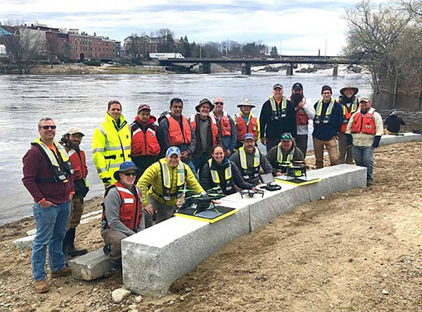
2019 Aquatic Airshow participants at Androscoggin River in Auburn, Maine, on May 1. (Photo: Mario Martin-Alciati, USGS)
The U.S. Geological Survey (USGS) and independent scientists gathered this month in Auburn, Maine, to evaluate the use of sensor-mounted unmanned aircraft systems (UAS) to gauge stream stage, velocity, bathymetry and discharge.
The technology is being evaluated and modeled to determine whether it will support the fast, accurate and safe measurement of rivers, especially when they are flooded or contain floating trees, ice or other debris.
Close to two dozen hydrologic, geospatial and scientific experts gathered in what has been dubbed the “2019 Aquatic Airshow” to assess the technology. They were led by John Fulton of the USGS Colorado Water Science Center, Jack Eggleston of the USGS Water Mission Area Hydrologic Remote Sensing Branch, and Joe Adams and Sandy Brosnahan of the USGS National UAS Project Office.
The USGS Water Mission Area works with partners to monitor, assess, research and report on a wide range of water resources and conditions, including streamflow, groundwater, water quality, water use and water availability.
The testing involved equipping drones with noncontact sensors, including ground-penetrating radar for measuring river depths, doppler velocity radar and cameras with velocimetric analysis for measuring water surface velocities and calculating mean-channel velocities; and high-resolution cameras for photogrammetric mapping of surface topography and vegetation structure.
All the evaluated sensors were equipped with GNSS receivers; some with RTK correction capability. Most of the drones used were equipped with a low-grade inertial measurement units (IMUs) for navigation.
Team members from the USGS Water Science Centers in Colorado, New England and Virginia collected ground-truth river monitoring data with acoustic doppler current profilers deployed from a boat and multiple other surveying techniques to verify the accuracy of the drone-based stream data.
Woolpert Chief Scientist Qassim Abdullah was one of two scientists from the private sector asked to participate in the airshow. Abdullah has more than 40 years of experience in analytical photogrammetry, digital remote sensing, and civil and surveying engineering.
For the event, Abdullah devised a process in which the data collected by the drones underwent Pix4D triangular adjustment to produce three-dimensional models of the water surface and river edges to assist the modeling of river velocity using the drone-based doppler velocity radar and large-scale particle image velocimetry.
USGS scientists are in the process of evaluating the data and modeling produced by this testing to conclude whether this technology will prove beneficial.
Abdullah said the airshow was a success due to the varied contributions from each member of the team, their diverse backgrounds and their shared focus on water research.
“This was a great example of how a public-private partnership can work together to activate and elevate necessary, groundbreaking technologies to address worldwide issues,” Abdullah said. “Airshow team members brought different perspectives, processes and applications to the testing, which not only proved essential for this project but will help with many others moving forward. I love working with this group and look forward to continuing to help advance these vital technologies.
Pix4D has announced Pix4Dfields, its first fully dedicated product for agriculture. A beta program to test the software is now open.
Pix4Dfields is designed to give users fast and accurate maps while in the field, with a simple yet powerful interface fully dedicated to agriculture.
“When we decided to create a fully dedicated product for agriculture, we wanted to go beyond the research and development and create a product that actually understands agriculture,” the company said in a press release. “So in July 2017, we opened a new office in Berlin fully dedicated to do exactly that: Understand the agriculture industry, listen to our users, and create a product that caters to all the main agricultural practices.”
Pix4Dfields is equipped with fast processing that provides accurate and instant results and an easy-to-use interface with tools tailored to agricultural workflows.
Pix4Dfields is currently available as a closed beta, which we are opening to select users to test it and provide feedback. The product will evolve at a fast pace with new and updated features being added with every new iteration, the company said
Pix4Dfields is currently available for macOS only; the next iterations will include Windows support as well.
Professional drone company Wingtra is partnering with photogrammetry company Pix4D. Pix4D’s software suite is now available to WingtraOne users, both directly and via Wingtra’s distributors.
WingtraOne, Wingtra’s main product, is a vertical take-off and landing (VTOL) UAV that enables data collection for a variety of industries. The partnership with Pix4D aims to augment its status with an end-to-end solution including 2D map and 3D model construction from aerial data.
The WingtraOne drone bridges the gap between traditional multi-rotors and fixed-wing drones, the company said. It takes off and lands vertically like conventional multirotors, but once in flight, the drone tilts forward to fly like a fixed-wing aircraft.
Being able to carry heavy payload such as the Sony RX1RII, the drone offers high mapping accuracy, while covering an area of 980 acres (400 Ha) at 3 cm/px (1.2 in/px) GSD or the equivalent of 570 football fields.
The WingtraOne is available in use in Europe, China, the United States and Australia for applications ranging from surveying and precision agriculture to glacier monitoring.
Wingtra (booth 109) and Pix4D (booth 415) are exhibiting at Commercial UAV Expo Americas, which takes place Oct. 24-26 in Las Vegas.
Map made by Pix4D pictures taken by WingtraOne with RX1RII camera. (image: Wingtra)
Turning Information into Insight. Wingtra’s diverse user base is complemented by Pix4D, whose product range is aimed at the surveying and agriculture industry, among others.
Pix4D has allows professionals to generate high-quality point clouds, orthomosaics, surface and terrain models from aerial imagery. Some of its popular offerings include Pix4Dmapper for precisely georeferenced 2D maps and 3D models, and Pix4Dag for accurate reflectance and index maps (NDVI, NDRE).
With WingtraOne’s autonomous aerial data collection and Pix4D’s advanced data-analysis capabilities offered as a single bundle, professional users can now expect a plug-and-play solution. “We are keen on collaborating strongly in our upcoming events. Actually we are meeting very soon at UAV Expo in Las Vegas,” Bailey said.
“The bond between the companies was established some time ago, since realizing the potential of pairing high-resolution aerial images with cutting-edge photogrammetry modeling software,” said Caroline Bailey, Pix4D regional sales manager for Europe. “We are very happy to announce the decision to become official partners.”
Leopold Flechsenberger, sales manager at Wingtra, added, “We have always aimed at providing the best survey-grade aerial imagery to our users, so Pix4D was an obvious choice from the start. From now on, Wingtra is offering a reduced price on WingtraOne drones, when bundled with Pix4Dmapper.”
The ancient city-kingdom of Kourion on the southwestern coast of Cyprus can now be “seen” by those with impaired vision.
Kourion, part of the UNESCO World Heritage Site of Paphos, was once an important urban center. While most of the archaeological remains — including several buildings with well conserved floor mosaics — date to the Roman and Early Byzantine periods, the most ancient finds connect to settlements and tombs of the Ceramic Neolithic period (circa 5500-4000 BCE).
A tactile map: In summer 2015, sections of the virtual 3D model, including the amphitheater, were printed in 3D and displayed in the visitor center with Braille explanations, providing an interactive history to those with visual impairments.
British drone manufacturer QuestUAV, in cooperation with the Cyprus University of Technology, acquired high-resolution aerial images of Kourion Archaeological Park with a surveying drone, and then created a virtual 3D model from the images with Pix4Dmapper Pro.
The QuestUAV team (a pilot and laptop commander) flew over 100 hectare of the archaeological park at 400 feet with a Q-200 Surveyor drone equipped with a Sony A6000 camera and a 16mm wide-angle lens, taking 330 aerial photographs during a 20-minute, fully autonomous flight.
The automatic camera trigger and the gimbaled camera system enabled acquisition of pin-sharp pictures, even at wind speeds of up to 40 kilometers per hour.
The images have a ground sampling distance of 2.5 centimeters with an overlap of 80 percent in flight direction and 65 percent sidelap. During the flight, the Q-200 Surveyor recorded the GPS coordinates of each camera position in a log file, allowing for image geo-location.
The entire survey took no longer than an afternoon.
Lorenzo Martelletta of PIX4D gives an overview of the company’s Pix4D image processing software while at INTERGEO 2015, which was held Sept. 15–17 in Stuttgart, Germany.
Pix4D image processing software is a mapping and modeling solution that can convert thousands of images into georeferenced 2D mosaics and 3D models.
Geospatial Solutions’ and GPS World‘s Art Kalinski reports from eMerge Americas, held May 4-5 in Miami. CartoData is a Mexican firm doing some very impressive end-to-end solutions including the use of Pix4D to build 3D models from UAV data. The company provides geographic information for public and private sectors, producing cartography and geomatics-related products and services.