Topcon Positioning Systems attended GEO Business in London this month to showcase its latest solutions to improve survey and geospatial workflows.
The event, which took place at Excel London June 4-5, showcased hardware, software and workflow technologies across capture reality, surveying solutions, engineering surveys, and GIS mapping and utilities, including the company’s new suite of 3D scanning solutions. The scanning solutions offer integrated software that enables high-speed data capture and immediate analysis for a wide array of geomatics applications.
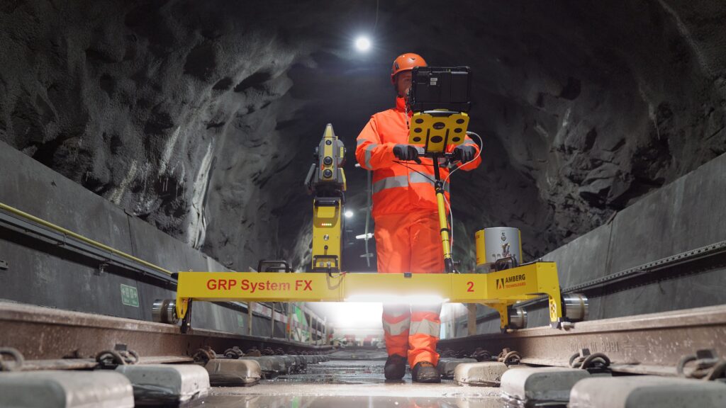
Topcon is partnering with Amberg Technologies on rail solutions. (Credit: Topcon)
“Smarter workflows for rail survey data”: Bruno Fileno, senior segment manager geomatics, gave an in-depth look at integration efforts between Topcon and Amberg Technologies that focus on how interoperable workflows streamline surveying tasks such as track alignment, geometry verification, and clearance assessment.
“Control, confidence, custody: How surveyors defend georeferenced SLAM workflows”: Phil Marsh, director of scanning sales EMEA, shared a practical framework for delivering georeferenced SLAM results, with tips on combining RTK with survey control and independent checkpoints, and building a lightweight QA pack to prove accuracy – producing outputs surveyors can get behind and clients can sign off.
“From ground to cloud: Transforming utilities with accessible digital workflows”: Nathan Ward, business development manager, utilities solutions EMEA, explored the newest innovations in utilities mapping, explaining how seamless data capture with the Topcon CR-H1 handheld device and automated cloud processing can deliver date-stamped records that cut delays, reduce rework, and speed up sign-off and payment.
Topcon Positioning Systems has become an authorized distributor of Pix4D’s photogrammetry software portfolio, expanding access to high-precision positioning and 3D mapping technologies.
The partnership aims to enhance reality capture solutions across various industries, including surveying, mapping, architecture engineering and construction, energy, utilities infrastructure, public safety, and forensics.
The agreement streamlines the procurement process for end-users by allowing them to access Pix4D‘s advanced photogrammetry software solutions through Topcon’s established global distribution network and ensures comprehensive technical support for users.
Topcon Positioning Systems has introduced the HiPer XRa GNSS receiver for surveying, mapping and construction applications. The new receiver is designed to benefit a wide variety of users, including construction professionals, surveyors, GIS professionals, archeologists, engineering firms and others who rely on quality, precision measurements. The HiPer XR supports GPS, GLONASS, Galileo, BeiDou, IRNSS, QZSS and SBAS.
The new receiver has advanced Topcon Integrated Leveling Technology (TILT) compensation, featuring a calibration-free and magnetic interference-immune integrated IMU that provides up to 60° of tilt for precision measurements in challenging positions. It has signal integrity protection, anti-jamming and anti-spoofing capabilities designed to keep data reliable, even in areas with interference or degraded signals.
Through the myTopcon NOW! Website users can access online training materials, firmware updates, and additional software resources.
Topcon Ninja Wildcat, one of the sponsored characters featured in the Get Kids into Survey campaign. (Image: Topcon)
Topcon Positioning Systems has expanded its support for the Get Kids into Survey (GKiS) project, now serving as the exclusive sponsor of the Global Brand Ambassador Hub. This new platform will offer a comprehensive range of resources to the project’s Brand Ambassadors, a worldwide community of volunteers who visit schools to advocate for surveying as a career and introduce students to the surveying and geospatial industries.
Get Kids into Survey originated in 2017 and was initiated by cofounder Elaine Ball through the creation of a poster that surveyors could use to explain the profession to children. Since its inception, the project has continued to highlight the work of surveyors for young audiences, backed by an industry keenly aware of the necessity to attract the next generation of surveyors.
The Hub will allow GKiS to develop and host resources for the global network of ambassadors and aims to increase participation in career fairs, workshops and educational activities across more than 30 countries.
By sponsoring a homework project with GKiS, Topcon will also have its own unique GKiS cartoon character, Yumi the Wildcat Survey Ninja. Yumi will be the face of the Topcon brand to young aspiring surveyors and be given her own Character Spotlight on the GKiS blog.
Research conducted by Topcon has shown that nearly a third of construction managers throughout Europe have identified skill shortages as a major challenge in their projects.
According to Topcon, this shortage stems from a combination of experienced employees leaving the industry and a lack of recruits. Programs such as GKiS represent just one example of the outreach and educational initiatives designed to address and reverse this trend.
“The GKiS project is about lifting the lid on the geospatial and survey industries for young people, and showing that they are exciting, future-gazing and technology-driven careers,” said Elaine Ball, co-founder of GKiS.
Topcon Positioning Systems’ U.S.-based Topcon Solutions Store (TSS) network now offers the Topcon Layout Navigator (LN) combined with HP SitePrint. The integration aims to advance construction automation and efficiency for a wide range of professionals including general contractors and mechanical, electrical and plumbing (MEP) contractors.
Integrating Topcon’s LN-150 with HP SitePrint’s autonomous robotic unit that prints site layout plans directly on construction floors aims to advance construction technology. The solution is designed to streamline the site layout process, which is to save time and cost by replacing manual layout methods with digital precision.
The LN-150 supports Wi-Fi and long-range Bluetooth communication. It is also compatible with cloud-based workflows to offer precise 3D layout capabilities that are increasingly vital due to labor shortages.
TSS now offers the solution across its 20-state network. Click here to learn more.
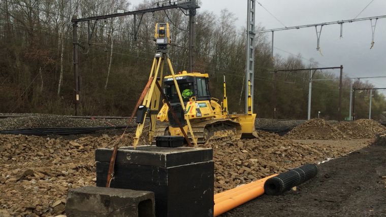
Belgian government-owned railway company, Infrabel, is responsible for ensuring that the country’s railway systems run smoothly. To do this, the company recently needed to renew the switches and crossings at the Kinkempois site, located in the Liege region of the country.
To ensure an efficient, safe and high-quality changeover, Infrabel partnered with construction specialist Jérouville, and when it came to choosing technology to help guide its machinery, the contractor turned to Topcon Positioning for its total station solutions.
According to Stéphane Lemaire, equipment manager at Jérouville, the team first dismantled and removed the previous set of foundations and the sub-foundations at Kinkempois. From there, the team installed new foundations to ensure the new switches have a good grounding for years to come.
At the site, navigation capabilities were compromised due to interference from overhead power lines. As a resolution, two Topcon total stations were used; one for each crawler dozer. Despite the challenging circumstances, the total stations were able to provide accurate readings for each dozer.
Before the bulldozers could get to work, surveyors used the data from the total stations to create three-dimensional models of the finished project using Topcon’s MAGNET software. These models were then shared with all stakeholders on the project. The MAGNET software allowed the entire team to have complete oversight of the project, whether they were on-site or back in the office.
Stéphane Lemaire said in a press release that Topcon’s total stations played a key role in getting the job done accurately on the first try.
“Traditionally, this has been a time-consuming process for projects like this, with a tracker on site who would manually ensure that the levels were correct,” Lemaire said. “However, with total station technology, the process only took three shifts across two weekends, compared to six shifts across two weekends.”
Vodafone and Topcon Positioning Group are developing a European precise positioning system, Vodafone GNSS Corrections, that will locate Internet of Things (IoT) devices, machinery and vehicles with a greater degree of accuracy than using individual GNSS.
Vehicles, scooters and robotic lawn mowers can be securely monitored in real time to within a few centimeters when connected to Vodafone’s global IoT network.
Vodafone GNSS Corrections will use technology from Topcon, which corrects inaccuracies from navigation satellite signals. Location accuracy is improved from a few meters to centimeters using Topcon’s dense European network of thousands of GNSS reference stations, especially when vehicles and devices are fitted with suitable antennas and receiver equipment.
Vodafone will offer a singular module configuration that can extend across national borders.
Vodafone is inviting select customers to join pilot customer trials in Germany, Spain and the UK, which will begin this month. The companies aim to test the service using a wide variety of devices connected to Vodafone’s global IoT network — one of the largest with more than 150 million connections — and its pan-European network covering 12 countries.
Pinpoint accuracy is critical to the mass adoption of vehicle-to-anything (V2X) technology used for driverless vehicles, autonomous machinery and robots. For example, e-bike riders could use Vodafone GNSS Corrections to provide details of their exact location and then alert other road users of their presence.
Vodafone GNSS Corrections also supports Vodafone’s efforts to improve V2X location accuracy, especially when sharing trusted data to help prevent unnecessary accidents and fatalities on Europe’s roads. As such, Vodafone is offering precise positioning as a complement to Vodafone’s new Safer Transport for Europe Platform (STEP) which allows entities to communicate with each other where no line of sight exists. Unveiled in March 2022, STEP has been successfully tested in Germany and the UK and will be made available via Vodafone Automotive and third-party apps later this year.
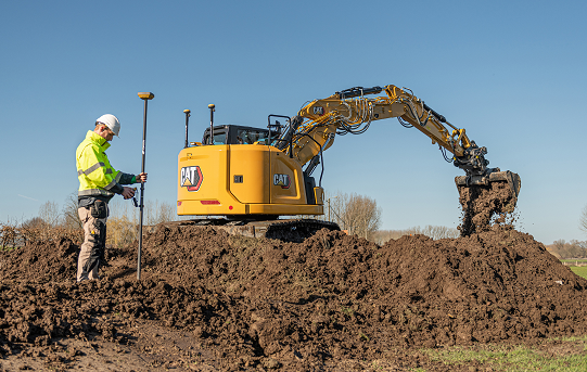
Topcon Positioning Group has announced a new option for Caterpillar Next Gen excavator users to leverage Topcon 3D machine control functionality together with Cat Assist features. As a result of new compatibility of the Topcon 3D Excavator System with Caterpillar factory-installed NGH sensors, customers will experience simplified installation of the Topcon aftermarket system into Caterpillar’s existing 2D excavator systems, in coordination with Topcon and Caterpillar dealers.
“With increased pressure for productivity and accuracy, and the industry’s need for skilled operators, the solution is timely,” said Jamie Williamson, Topcon executive vice president. “The customer will have the benefit of Topcon 3D Excavator System and Caterpillar Assist features working together. Once the user is acquainted with the combined system, it will be easy to be a more productive operator.”
The Topcon system is designed to provide real-time, dynamic, on-screen bucket location and design views, resulting in the operator cutting grade faster and more accurately. The operator can create, cut and check designs directly from the cab. Together with Caterpillar boom and bucket automation, operators can deliver quality work all day long with less fatigue, according to Topcon.
Tilt rotation support for automatic excavation, bring-your-own device, mobile apps included
Topcon Positioning Group announces advances to its portfolio of machine control solutions that are designed to provide contractors with better performance and profitability in earthmoving applications. The new solutions include tilt rotator functionality for the Automatic Excavator system, mobile and bring your own device (BYOD) display options, and other additions.
Topcon made the announcement at ConExpo, taking place this week in Las Vegas.
Tilt and rotation for Automatic Excavator
Photo: Topcon
Advanced tilt rotator functionality will allow Automatic Excavator operators to easily swivel or tilt the bucket with automatic boom control for faster and more efficient excavation.
“If excavator operators are in situations such as at the top of the slope, grading a long incline and not totally perpendicularly lined up, positioning the cutting edge of the bucket to the surface is now more easily attainable with the tilt rotator functionality,” said Murray Lodge, senior VP of construction.
“Operators can excavate more quickly, moving the excavator fewer times, with less wear and tear on the chassis — all with the proven hydraulic, automated control the system offers,” Lodge said. “It is also extremely beneficial when navigating around manholes, trenches, and generally tight spaces.
“We have had tilt rotation functionality for a number of years, but in previous systems,” he said. “Now, it will be available for the Automatic Excavator as well. Operators are ready for this tool, and once they see the new capabilities it will bring, they will not want to work without it.”
Bring your own device – MC Mobile
Photo: Topcon
Another resource in the small excavator and compact track loader machine control offering includes bring your own device (BYOD) options that can work as a substitute for control boxes in some applications. This solution incorporates the same hardware for Topcon 3D machine control with an indicate-only option running on Android devices with a free app, Pocket-MC, which is part of the new MC Mobile system family.
“Pocket MC can be downloaded from the Google Store and used right from a phone or tablet either as a simple entry-level machine controller option for contractors who want an inexpensive way to speed up the productivity of their fleet, or as a backup on the job site to a fully featured controller — so, operators are still working, timelines keep moving,” Lodge said.
Pocket MC also allows for a local positioning system (LPS) option for excavation. Now, an LN-150 Layout Navigator total station can be used as an economical alternative to fully featured traditional total stations.
Sitelink3D enhancements
Enhancements also have been made to the Sitelink3D job site monitoring and management system, including a pay-as-you-go point-based service model and a Haul Truck app, giving contractors more visibility into workflow management and the flexibility to use it in the way that best fits their operation.
“These latest releases strengthening the earthmoving portfolio are part of our commitment to continually developing greater connectivity and automation for today’s job site to accelerate efficiency across all aspects of a project,” Lodge said.
Over the past two years, I’ve been sharing my view on land surveying over a variety of topics. One of the constant themes I try to maintain is technological improvements and how surveyors need to continue to embrace new applications and equipment.
While I will also argue that we cannot forget our surveying roots (see GPS World, March 2017), we still need to keep an eye on future technologies, means and methods to increase our productivity and profitability as well.
With this idea of peeking at the road ahead, I traveled to Berlin, Germany, to cover Intergeo 2017, an international trade show for everything geospatial.
Held every year at different venues around Germany, Intergeo is the world’s largest conference and exhibition for geodesy, geoinformation and land management. The theme of the conference this year was “We are bringing worlds together,” and based upon the number of vendors, new equipment and applications, and record breaking attendance, it was quite evident they hit their mark.
The numbers were astounding: 580 vendors from 37 countries, 18,000+ visitors from 100+ countries, all packed in six interlinking halls covering more than 325,000 square feet (7.5+ acres). When I spoke with several contemporaries who previously attended Intergeo, all warned me to be ready for the size and scale of the facility, the number of vendors, and the large spaces occupied by the big survey players. Truly thinking this rhetoric was hyperbole, I went with guarded expectations. Boy, was I in for big surprise.
Walking up to the entrance, one could sense immediately the size and enormous presence of this conference. The registration lines were easy and efficient, with plenty of entry gates and attendants to help with any information. When I entered the first hall for my initial visit, the prior warnings about the size and scale were quite true. This conference was three days long, and I knew I was going to need every minute to cover all the bases.
My account here is broken into four sections — one hall per day. Leica, NovAtel, Laser Technology and Septentrio were among the first booths I encountered on day one. Javad, ComNav, Hemisphere and Emlid were in the next hall over, and can be found below “Behind Door Number Two.” Day three found me hobnobbing with CHC Navigation, EOS and Swift Navigation; look for them under “I’ll Take Hall Three for $200, Alex.” I topped off my Intergeo experience interviewing NavCom, Tersus and Trimble in “The Big Finish (Or Is It?)”
ENTERING ANOTHER DIMENSION…
Coming into Hall 1.1, the first thing that catches one’s eye besides the vastness of the entire space is the size and depth of the Hexagon exhibit. Hexagon is the parent company of Leica, NovAtel, and several others, and all were there displaying new products and software for a multitude of geospatial needs.
I was introduced to the new Leica GS18T GNSS RTK rover (Leica Geosystems debuts GNSS RTK rover at Intergeo 2017) with many new upgrades, including being able to measure a point while the unit is not being held plumb. Yes, you read that right; the unit has an inertial measurement unit (IMU) built in that compensates for any rod tilt and corrects the location back to the bottom of the rod. Now it is possible to collect a GNSS location to places and objects no longer thought possible.
This feature has been available with the “J-Tip” from Javad for the past year: now Leica has added the capability to the GS18T.
While the demonstration took care of my skepticism of the unit, it raised different concerns with the field personnel using it. This method of “no bubble” is fine for this unit, but I can envision crews getting sloppy with conventional GNSS and total station prism rods when mixed with this new technology. This will increase the need for proper training and trust that the all rod-based equipment is used in its intended manner and procedure.
NovAtel was on hand with presentation of a full line of GPS receivers, boards and peripherals, including its GAJT line of anti-jamming receivers as well as an “interference” toolkit of analyzing software modules. With the solid product line and software, the company motto of “assured positioning” bodes well for its users.
Laser Technology Inc. has provided many measurement breakthroughs over the past few decades, and its introduction of the TruPoint 200h is no exception (see Laser Technology highlights TruPoint 200h at Intergeo 2017). The company has taken the TruPoint 200 line of measuring devices and expanded its capability with phase shift and pulse diode measurements, which means the unit will determine the most accurate method based upon reflectivity. This is also paired with a data collection and reporting application on your Android smartphone to greatly expand your ability to share your data.
Also at Intergeo introducing a new GNSS receiver was Septentrio, a navigation systems developer from Belgium. Septentrio was showing the Altus NR3, a lightweight multi-constellation receiver aimed at the surveying and mapping community. This new unit boasts an AIM+ system designed to monitor and protect the user’s data from jamming and spoofing so the collected data is confidently accurate.
Carlson displayed its new BRx6 multi-GNSS receiver along with the RT3 tablet data collector. The BRx6 receiver expands the Carlson family of GNSS products to include connection to most RTN systems worldwide as well as the Atlas L-band correction service that is beginning to gain many followers. Paired with the new RT3 tablet, these products continue the look, feel and service that Carlson users have enjoyed for many years.
Sokkia was there with a full complement of surveying and monitoring equipment, with the GCX3 GNSS receiver being the main focus of their new products. This unit sets the bar even higher for light and efficient GNSS receivers as it weighs only 440 grams with the batteries, yet is more capable than many similar systems on the market.
Another new GNSS receiver introduction was from Hi-Target, the iRTK-5. This new model is the one of the first units to have an OLED touchscreen on the receiver. It supports reception from all major GNSS constellations as well as the L-band correction service. Hi-Target prides itself on a new proprietary differential correction technology that analyzes the integrity of data from all sources before providing a position. This model also has a 4G LTE chipset that will communicate with almost all cellular systems worldwide.
One thing that stood out to me that differs greatly from surveying in the U.S. is the proliferation of monuments and monitoring points/devices used by surveyors throughout the world. So, the multitude of vendors offering varying kinds of targets, prisms, and survey point markets should not have shocked me, but it still did. It was quite impressive with the walls of targets and prism assemblies for many different applications along with the tables of nails, tablets, monuments and vault systems used by surveyors worldwide. Among the notables were Rothburcher Systeme and Bohnenstingl, who both offer a complete line of products beyond most surveyor’s imaginations.
The Juniper Systems booth showcased the Mesa2 rugged tablet and the Geode sub-meter GNSS receiver, both designed with efficient mapping collection in mind at an affordable price point, yet rugged enough to take on most environments. They were also highlighting their CT5 rugged smartphone and CT7G rugged tablet as solid products for any surveying and mapping data collection need.
BEHIND DOOR NUMBER TWO
After navigating the first of four conference areas, I wondered if all the remaining halls would be just as impressive. Hall 2 did not disappoint, as the exhibit spaces were just as big and remarkable as the first one.
Already a major entity within the GNSS community, Javad came to Intergeo 2017 to introduce its entry into the UAV market, the Triumph F-1. Unlike other UAVs, this unit was designed starting with the GNSS engines Javad is known for; engineers then built the flying craft around the brains of the system. It utilizes the same DNA of the Triumph-LS receiver along with ease of Javad software, all on a multi-rotor platform with hot-swappable batteries.
Aimed for more agricultural users, ComNav introduced a lightweight GNSS receiver, the T30, and a new software guidance system compatible with most tractor configurations. This system is designed to be more efficient and precise than OEM tractor guidance as well as more customizable for the user.
The company behind the new Atlas L-band correction service, Hemisphere GNSS, also provided introductions to several new products at Intergeo. In addition to several navigation chipsets for OEM use, they also introduced the 321+ GNSS Smart Antenna. This new receiver is multi-frequency and multi-GNSS with an Athena RTK engine and Atlas L-band global corrections to cover most positional needs. With hot-swappable batteries, this unit will run over 12 hours on two sets that are provided.
EMLID may be a newcomer to the GNSS environment but they are making noise by offering new products and technology at price points for more consumers. At Intergeo, they were demonstrating the Reach RS GNSS receiver with RTK capability, the Reach GNSS module for UAV systems and the Edge module, an advanced drone controller with HDMI video input and 5.8 GHz data link. These guys are my sleeper pick for becoming a bigger player in the very near future.
Topcon’s space, which included industry partner Intel included an interactive dome using their “Immersive Point Cloud Workspace” software and 3D point cloud data to give attendees a virtual reality tour of sites previously mapped with Topcon equipment and software. This four-meter dome was a popular stop with visitors, as was the product introductions of their SmoothRide software and the MAGNET Collage desktop mass data processing software. In addition, another product showcased in conjunction with Intel was their UAV systems, led by the Sirius Pro fixed wing vehicle and the Falcon 8 multi-rotor vehicle.
The main presentation from Bentley to the surveying/GNSS community was the increased capability of their ContextCapture software module. With 3D point clouds and virtual reality systems become the norm, Bentley has upped their game with visualization tools and features within this module not found in many point cloud software packages. The biggest improvement is the ability for survey-grade data acquired through laser scanning, LiDAR and photogrammetry to be easily input and manipulated for many different uses. From BIM to roadway corridor modeling and asset management, these improvements are making the utilization of 3D data more seamless.
Something that caught my eye initially as a novelty was TinyMobileRobots, a Danish company producing a small unmanned cart for marking surfaces. They currently have three products: the TinySurveyor, the TinyLineMarker, and the TinyPreMarker. All have GNSS receivers that operate autonomously on a predetermined route and carry a paint can for marking specific points. From marking athletic fields to paint striping, they might be on to something quite unique but very cool.
I’LL TAKE HALL THREE FOR $200, ALEX
Hall 3 brought us to CHC Navigation and their full range of surveying and mapping products. Highlighted during our discussions with them was the M6, i70 and i80 GNSS receivers and the Apache 5 USV boat for hydrographic applications. It was quite evident how large of a company CHC is and how vast their global presence is so don’t be surprised to see them in North America soon.
EOS Positioning Systems is another smaller GNSS receiver producer that is targeting the mapping community with the lower entry pricing and smartphone application interfacing. From the basic L1 receiver for mapping to the multi-constellation, triple-frequency model including Atlas L-band corrections, EOS is providing an easy to use package at an affordable price point.
Another entry in the OEM board/system provider of centimeter-level accuracy systems is Swift Navigation and their Piksi line of products. From agricultural applications to autonomous vehicle positioning, they are providing navigational systems that will guide our future. As the surveying community expands its use of unmanned vehicles, I would not be surprised to see Swift at the forefront of this effort.
Another member of the Hexagon family, the Geomax display was loaded with everything imaginable for measuring and remote sensing. The main introduction for Intergeo 2017 was X-PAD Office Fusion, an all-in-one software package that allows the data from various sources to come together in one place for creating and manipulating 3D models. While I was not familiar with Geomax, it was quite evident that their customer base, while European-centric, was big and quite loyal to the brand.
A newcomer to the surveying world is Pix4D and their photo processing software. Used by many UAV enthusiasts and now surveyors, Pix4D has quickly become one of the largest providers of software for creating orthometric photos that are georeferenced to known coordinate systems and GIS databases. Most of their success has been because of ease of use and affordability versus the leading surveying software packages. They are also industry partners with Esri and DJI, so having big friends in popular places has helped their cause. Look for more great stuff from them for surveying applications in the near future.
THE BIG FINISH
As I entered Hall 4, I began to wonder if I was done with the major attractions and getting into the bit players. I was wrong.
The first stop was Geozone, who was introducing a new receiver, Falcon SF, through a collaboration with NavCom. This new unit features multi-constellation and multi-frequency collection, but also includes Starfire, a global system designed and maintained by NavCom that is a satellite-based correction signal and provides accuracy of 5 CM anywhere in the world. This correction system comes standard with a subscription when you purchase the receiver, which is unheard of in most surveying environments. This is another product I predict that will be making more of a global presence in short time.
Tersus GNSS was at Intergeo to introduce many OEM navigation boards and an RTK system for surveyors and autonomous control systems. The Tersus David RTK system is designed to turn your smartphone into a high accuracy GNSS data collector. This system is highly durable and compact so it will accommodate many different mapping needs.
Another company that has global reach but not much exposure to U.S. business, South Surveying & Mapping Instruments, wouldn’t give an attendee the impression that they are a small player in the surveying world. Their exhibit space was impressive, ranging from simple theodolites to high accuracy robotic total stations, RTK GNSS receivers and fixed-wing/multi-rotor UAVs.
As lidar technology becomes more available and affordable, a stop at the Riegl booth was a must. They were introducing many new products at the Intergeo 2017 show, including the miniVUX-1DL UAV laser scanner for multi-rotor and fixed-wing aircraft. This little beauty weighs under 3 kg and fits on most scalable UAV platforms.
Another fun item on display was the VMX-2HA Dual Scanner Mobile Laser Scanner, which looks like a high-tech octopus on top of your vehicle. This unit collects 2 million measurements per second as well as 9 x 12MP camera images at various angles. As the miniaturization of technology continues, I see RIEGL continuing to lead the lidar segment well into the future.
Just when I thought I was almost done, I realized that there was one major player left that I had not seen: Trimble. They were in the back of Hall 4 across almost the entire width of the conference space. Everything geomatics, remote sensing, and navigation; it was here in one of the biggest exhibition spaces at Intergeo 2017.
All the latest surveying instruments were here, including the R10 GNSS receiver and SX10 scanning total station. The new items for surveying at this show were numerous; the C3 and C5 mechanical total stations with autofocus, Catalyst software with GNSS receiver for smartphones, the T10 rugged tablet for survey and GIS applications, and OEM receiver boards (BD940-INS, BD992-INS and BD990).
Also included within the Trimble space were Nikon and Spectra Precision branded instruments as well as the latest acquisition, Applanix GNSS-aided inertial movement systems. While Trimble has grown considerably in the past decade, it seems as nothing will slow them down. If they continue to introduce great products and technology, I wouldn’t bet against them.
BUT WAIT, THERE’S MORE…
There were three more halls, with two of them being organizations and information booths. Hall 6, however, has grown into a standalone space as “Interaerial Solutions,” Europe’s biggest UAV show. All the main players were in here (including DJI, DroneDeploy and over 150 more) so almost everything imaginable with UAVs can be found here.
During the conference, the adjacent courtyard was utilized for UAV demonstrations and product introductions. It will be interesting to see in the coming years if this segment of measurement and remote sensing will continue to expand with number of vendors/suppliers or if it will get absorbed by many of the bigger players within the geomatics community.
INTERGEO 2017, IN RETROSPECT
The common theme/message through this gathering was digitalization, “smart cities” and the evolution of the occupations that work within these environments. Intergeo is an impressive gathering of likeminded people discussing how to manage the increasing waves of data through technology, analyzation and thought processing.
While I can’t say that these types of gathering do not happen in the U.S., it is not as obvious as the annual assembly of Intergeo in Germany. The surveying community in the United States needs to hold a similar “summit” to help guide the profession toward its future goals. The one thing I have always appreciated about surveying is how it does embrace technology and forward thinking yet must rely on the past to tell us where we have been.
Digitalization is here and cities will get smarter with or without us, so it’s up to us as surveyors to keep looking forward with the times. Global measurement and navigation will be a big part of that, so let’s put our thinking caps on to see what we learn next.
Until next time, guten tag und gute gesundheit.
A big thank you also goes out to my fellow Intergeo members Ryan Gerard, Mike Joyce, and Allison Barwacz for making this a wonderful experience.
Monitor, manage and evaluate monitoring data, optionally trigger alarms
The Delta Solutions deformation monitoring system uses several software and hardware components — Delta Link, Delta Log, Delta Watch, Delta Sat and the Topcon MS AXII total station — to provide accurate and reliable monitoring measurements and associated reporting for asset protection. Delta Watch delivers accurate and reliable data in a variety of reporting formats to fit a project’s needs. Data from the total station, GNSS receivers, leveling devices and sensors can be processed and analyzed individually or as a network-adjusted solution. Delta Watch’s optional Delta Sat GNSS processing module allows for stand-alone GNSS monitoring or combined GNSS and total-station network adjustments. Delta Link provides hardware support communication for autonomous operation in the field, managing each power source to maximize system availability, while Delta Log provides an intuitive interface to manage observations, target types and measurement scheduling.
GPS data collector for utilities, mining, forestry, agriculture
The SXPad 1000P is an affordable, rugged handheld GPS data collector specifically designed for mobile GIS users in applications such as water, electric and gas utilities, transportation, mining, agriculture and forestry. The high-performance 1000-MHz device is designed to give professionals the power needed to work with maps and large data sets in the field. It has an IP67 waterproof seal and can survive 5-foot (1.5-meter) drops to concrete. Its 3.7-inch color touchscreen (full VGA) is sharp and is sunlight readable. Standard features include a battery life of more than 10 hours on a charge, 8-GB internal storage, and slots for MicroSD cards and SIM cards as well as Windows Mobile 6.5. The SXPad 1000P also offers a 3.5G cellular modem, Wi-Fi, Bluetooth, video capture and a 5-megapixel camera. It is optimized for GPS/GIS field data collection using its 1-to-3-meter accuracy internal GPS receiver or one of Geneq’s high-performance SXBlue GPS receivers for sub-meter and centimeter-level accuracy.
Glean and share insight from big data, internet of things
Esri ArcGIS 10.5 offers next-generation analytics technology by helping organizations glean insight from enterprise data, big data and the Internet of Things (IoT) and share that insight in intuitive ways. It includes improved capabilities for handling large-scale analytics and big data; a drag-and-drop interface that streamlines the creation of spatial analysis through maps, charts and graphs; and collaboration features to connect and analyze information across the enterprise. The new release is powered by Esri ArcGIS Enterprise, a significant evolution of the technology formerly known as ArcGIS for Server. ArcGIS Enterprise has been updated with improved power to process and analyze large, disparate datasets.
Entry-level device for construction, public safety
The Faro FocusM 70 is an entry-level laser scanner for construction building information modeling (BIM) and public safety forensics. Features include an IP54 rating for use in high particulate and wet weather, high-dynamic-range imaging, an acquisition speed of almost 500,000 points per second and extended temperature range. Data captured can be used with various third-party software packages. The Faro FocusM 70 is specifically designed for both indoor and outdoor applications that require scanning up to 70 meters and at an accuracy of +/– 3 millimeters.