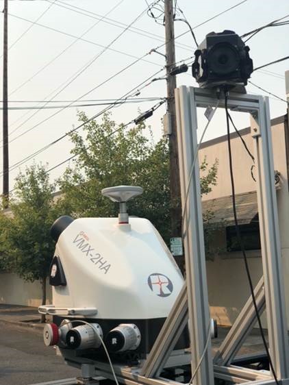
NV5 Geospatial has acquired the new Riegl VMX-2HA dual-scanner mobile mapping system. The system will initially deploy in utility and transportation projects and enable NV5 Geospatial to collect highly accurate, feature-rich data at highway speeds.
The flexibility, ease of setup, and smaller footprint will also allow the use of the VMX-2HA on various platforms, including boats, all-terrain vehicles and trains.
The VMX-2HA delivers mobile point clouds at a resolution of 1,000 to 4,000 points per square meter (pops) and 0.08-foot vertical accuracy in terms of 95% confidence intervals. It also features a high-speed 10 GigE link, which supports reliable data acquisition of up to 2 million measurements per second and image data from all integrated cameras.
NV5 Geospatial will launch the VMX-2HA as part of a mapping project for a large U.S. utility company and implement it for work being done for the U.S. Department of Transportation.
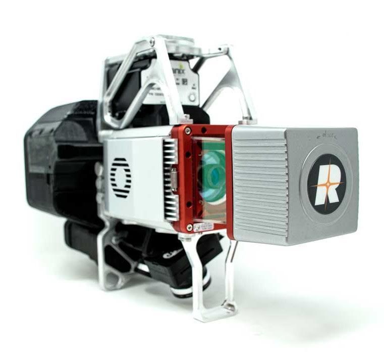
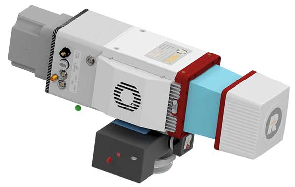
GeoCue Group has released the True View 615 and True View 620 UAS lidar 3D imaging systems. The True View systems are compact, survey-grade 3D imaging sensors designed for small unmanned aerial systems.
True View 615 and 620 are equipped with Riegl’s miniVUX-2UAV laser scanner integrated with dual photogrammetric cameras. Position and orientation is provided by an Applanix APX-15 (True View 615) or extreme accuracy APX-20 (True View 620).
All True View 3D imaging systems are bundled with Applanix POSPac, True View EVO post-processing software and True View Reckon data management solution.
The Riegl laser scanner and dual photogrammetric cameras have been carefully configured to provide a fused lidar/imagery field of view of up to 120°. The system includes full post-processing software that generates a stunning ray-traced 3D colorized point cloud and geocoded images.
An upgrade path will be available to promote a True View 615 to a True View 620 by adding the Applanix APX-20 external inertial measurement unit.
The True View product line gives mappers and surveyors the ability to deliver high-quality analytic data with exact accuracies. These deliverables are generated using workflows and tools within GeoCue’s post-processing software, True View EVO. Examples of derived products include bare Earth models, profiles, cross sections, topographic contours, volumetric analysis and more.
“Our Quanergy-based True View 410 has rapidly become the standard for general purpose drone 3D Imaging, where moderate vegetation penetration and accuracies of 5 cm RMSE are adequate,” said GeoCue’s President, Lewis Graham. “The True View 615/620 provides a solution for situations where deeper vegetation penetration, wire extraction and extreme accuracy are required. These are great new additions to the True View product line.”
The True View 615/620 will be available for shipment late June.
The miniVUX-2UAV airborne laser scanner. (Photo: Riegl)
The Riegl miniVUX-2UAV is a lightweight airborne laser scanner designed specifically for integration with unmanned aerial vehicles and systems.
Riegl added the new miniaturized UAV sensor to its portfolio of professional solutions for UAV-based surveying.
The sister type of the miniVUX-1UAV sensor, the miniVUX-2UAV offers 100 kHz and 200 kHz PRR. With the 200-kHz PRR, the sensor provides up to 200,000 measurements per second, and thus a dense point pattern on the ground for UAV-based applications that require the acquisition of small objects.
The Riegl miniVUX-2UAV makes use of Riegl waveform lidar technology, allowing echo digitization and online waveform processing. Multi-target resolution is the basis for penetrating dense foliage, and the wavelength is optimized for the measurement of snowy and icy terrain.
In addition to the stand-alone version of the miniVUX-2UAV, Riegl also offers fully-integrated solutions.
Riegl now offers several new sensors and systems for airborne data gathering at various elevations.
At Intergeo 2018, the company unveiled sensors designed for low-flight altitudes, such as with UAVs. Riegl also introduced sensors designed for medium-flight altitudes used in large UAS/UAV/RPAS with higher payload capacity or in manned helicopters, and scanners and systems for data acquisition at high flight altitudes using manned fixed-wing aircraft.
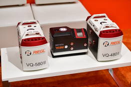
The Riegl VQ-480II and VQ-580 II on display at Intergeo 2018. (Photo: Riegl)
Medium altitude. The Riegl VQ-480 II (Mark 2) and VQ-580 II (Mark 2) are designed for airborne applications at mid-altitudes for use on both manned and unmanned aircraft. Based on the capabilities of their predecessors VQ-480 and VQ-580, their new, sophisticated designs lead the quality of the systems to a new standard of performance and user-friendliness.
Both offer a measurement rate of up to 1,250,000 measurement/second and a wide field of view of 75 degrees, suitable for corridor mapping, city modeling and applications in agriculture and forestry.
With approximately 10 kg of weight, they are ready for integration into helicopters as well as unmanned UAVs with a higher payload capacity, and are compatible with stabilized platforms and even small hatches.
The VQ-480 II and VQ-580 II are prepared for smooth GNSS/IMU integration, offer interfaces for up to five optional cameras, and are equipped with a removable storage card and an integrated SSD for data storage.
While the VQ-480 II works at a laser wavelength of 1550 nm, the VQ-580 II works at 1064 nm wavelength suited to measure on ice and snow.
Laser scanning. Riegl’s VUX series, focusing on unmanned laser scanning, has also been expanded. With the Riegl VUX-240, a new airborne lidar sensor with less than 4 kg weight and a sophisticated design offering 75-degree field of view is now ready to be integrated on both small manned and larger unmanned aircraft.
The high measurement rate of 1,500,000 measurements/second and a high scan speed of up to 400 lines per second are the basis for high scan efficiency, especially in applications like power lines, railway tracks, pipeline inspection or topography in open-cast mining. Interfaces for an optional GNSS/INS system integration and up to four optional cameras are further convincing key features of the new scanner.
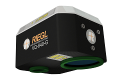
The Riegl VQ-840-G. (Photo: Riegl)
Bathymetry. For the bathymetric segment, the Riegl VQ-840-G has entered the marketplace. Designed for combined topographic and hydrographic surveys for use with large UAVs from lower flight altitudes, the scanner carries out laser range measurements for high-resolution surveying of underwater topography utilizing a green laser beam.
The scanner’s compact, lightweight and robust housing also can include an optional digital camera and an additional, fully integrated infrared laser rangefinder, and is compliant with typical hatches in aircrafts and with stabilized platforms.
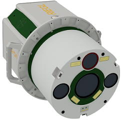
The Riegl VQ-880-GII. (Photo: Riegl)
Airborne laser scanning. The Riegl VQ-880-GII is a further improvement of the VQ-880-G topo-hydrographic airborne laser scanning system, offering online waveform processing and full waveform recording.
The improved setup includes a green laser channel, an integrated infrared laser channel, and an integrated dual camera system for RGB and IR. Typical applications include coastline and shallow water mapping, acquiring base data for flood prevention, and measurements for aggradation zones.
Also available are the VQ-780i airborne laser scanner and the VQ-1560i dual wavelength airborne mapping system.
The Commercial UAV Expo takes place Oct. 1-3 at the Westgate in Las Vegas. The expo brings together more than 3,000 professionals, and provides both education and an exhibit floor filled with high-precision UAS technology.
LidarUSA showcases revolutionary tech.LidarUSA will be at Booth 515, discussing its lidar products and the impact of the technology on the UAV industry.
“Whether you’re documenting a road accident scene at night, designing rice field irrigation systems or surveying archeological sites under dense forest canopies, advances in 3D mapping and geospatial data capturing are making these once time-consuming tasks, quicker and more efficient than ever before,” the company explains.
Pilot a WingtraOne. Wingtra, in collaboration with RDO Equipment Co., will be attending Commercial UAV Expo, North America’s trade show and conference for the commercial drone market.
Wingtra will be demonstrating its WingtraOne drone on Wednesday, Oct. 3, at the William Bennet R/C Airfield. The demonstrations begin at 8 a.m., with hotel pick-up provided at 7:30 a.m.
Register here for the demo, or visit Wingtra’s booth is 1404 in the Westgate.
RIEGL exhibits sensors, systems.RIEGL will be exhibiting at Booth 309 during the conference, showcasing its unmanned sensors and systems as well as the miniVUX-1UAV.
The miniVUX-1UAV is integrated onto a DJI-M600 with the RIEGL Integration Kit 600. It is a user-friendly, cost-efficient miniaturized lidar sensor for unmanned laser scanning to acquire survey-grade measurement data through the use of remotely piloted multi-rotor, rotary-wing or fixed-wing UAVs for a variety of applications.
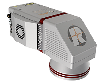
The miniVUX-1DL. (Photo: Riegl)
The miniVUX-1DL is a downward-looking lidar sensor for unmanned laser scanning with a special design tailored to meet the needs of corridor mapping tasks through its downward looking capability, its optimized field of view, and its small size.
Microdrones offers post-show event.Microdrones, which offered a series of workshops during the expo, is providing an in-depth technical symposium following its conclusion. The Key presenter is Mohamed Mostafa, director of mdSolutions at Microdrones.
On Oct. 4, expo attendees are invited to join ASPRS for an additional in-depth technical symposium led by Mostafa. Registration at the Commercial UAV Expo is required and the ASPRS UAS Symposium is an optional add-on event.
The symposium features detailed technical discussions on high-precision mapping by drones including lidar, photogrammetry, GNSS, inertial, datums, post processing, best practices and quality control. Real-world datasets acquired in the U.S. and Canada will be used to demonstrate the concepts and best practice of precision mapping by drones.
Other presenters at the symposium are:
Karen Schuckman, PLS, CP, CMS, Pennsylvania State University
Tersus David RTK is a real-time kinematic solution for centimeter-level accuracy using a smartphone. By plugging into a smartphone with a USB cable, The Tersus David turns the phone into an RTK rover, geographic information system (GIS) collector and RTK base. It supports GPS L1/L2, BeiDou B1/B2 and GLONASS G1/G2 signals. The rugged design enables it to operate in harsh environments.
The Riegl VMX-2HA is a high-speed, high-performance dual-scanner mobile mapping system that provides dense, accurate and feature-rich data at highway speeds. With 2 million measurements and 500 scan lines per second, the turnkey solution is suitable for survey-grade mobile mapping applications. The powerful technology in the Riegl VMX-2HA is comprised of two Riegl VUX-1HA high-accuracy lidar sensors and a high-performance INS/GNSS unit housed in an aerodynamically shaped protective cover. A camera interface for up to nine optional cameras enables the lidar data to be complemented by precisely georeferenced images.
The ZEB-REVO RT is the next generation of the ZEB-REVO — GeoSLAM’s lightweight, handheld laser scanner that allows rapid, simple mapping of complex, indoor and multi-level spaces. The ZEB-REVO RT uses Wi-Fi technology to seamlessly connect the scanner to a mobile phone or tablet, allowing for real-time data visualization as the user walks and scans. The simultaneous scanning and processing of 3D data removes the need for post-processing, effectively slashing project survey times in half. The technology is so rapid, users can scan and process a three-story building in 30 minutes.
MapAnything Connector for ArcGIS gives users a map view of Esri ArcGIS Online data inside Salesforce with their organizational data for strategic planning and analysis. The add-on app serves as a bi-directional integration layer between the programs, enabling customers to access their ArcGIS mapping and location intelligence inside the MapAnything Platform. Once connected, the MapAnything user interface helps Salesforce users view and interact with Esri maps and data alongside their existing customer and business data, exposing new opportunities to drive revenue and increase efficiency; improve decision making by aligning two core systems of record, the GIS system and the customer relationship management (CRM); and make it easy for GIS professionals to share insights seamlessly with their counterparts. The application has uses across retail, commercial real estate, telecommunications and economic development.
Generates Realistic Test Scenarios for a wide variety of applications
The SMW200A GNSS simulator can be extended to up to four RF outputs and allows GNSS signals to be simulated simultaneously in multiple frequency bands for multiple antennas. It can internally simulate a complex interference environment in parallel with GNSS signals. To test multi-frequency and multi-antenna systems, users have access to 72 GNSS channels that can be assigned to up to four RF outputs. The SMW200A can generate QZSS and SBAS signals as well as GPS, GLONASS, Galileo and BeiDou signals, enabling users to quickly and easily verify the position accuracy of their receivers under realistic conditions. An internal noise generator can generate complex interference scenarios with multiple interferers.
Multi-frequency, four constellations for survey and GIS
The Altus NR3 is a multi-frequency, quad-constellation (GPS, GLONASS, BeiDou and Galileo) RTK receiver for survey and GIS applications. It features Septentrio’s AIM+ interference mitigation and monitoring system, allowing continued operation in the presence of both intentional and non-intentional interference. It combines advanced GNSS features with a robust communications suite in a compact, low-power and easy-to-use unit. The Altus NR3 is configurable as either a rover or a base station. It offers one-touch logging and Septentrio’s on-board web interface so users can monitor and configure the unit as well as collect data using any Wi-Fi-capable device.
VersaPNT provides virtually failsafe battlefield navigation, even in GPS-denied environments, to protect critical networks. The new, ground, air or sea vehicle-mounted unit is designed for military environments, with a ruggedized, compact, low-power and lightweight form factor. It provides continuous mission assurance and command, control, communications, computers, intelligence, surveillance and reconnaissance (C4ISR) support, even in hostile environments.
The SyncServer S650 SAASM server incorporates a Selective Availability Anti-Spoofing Module (SAASM). The SAASM capability provides a highly secure, accurate and flexible time and frequency platform for synchronizing mission-critical electronics systems and instrumentation applications in the defense market. The SAASM received the GPS Directorate security approval to incorporate a military-grade, GPS SAASM receiver module, enabling U.S. armed forces to deploy features of the commercial SyncServer S650 in a military-grade configuration and allowing for a migration path to GPS Military Code (M-code) support.
Superior multi-constellation tracking for uavs, survey vessels
The multi-constellation D-Helix Antenna is capable of superior tracking of signals from GPS L1/L2 L-Band, GLONASS L1/L2, BDS B1/B2/B3 and Galileo. The quadrifilar helix design of low wind-resistance makes it suitable for UAV positioning and navigation. The increased antenna gain and beamwidth ensure better signal receiving performance at low elevation angles; the low noise design also reduces interference and improves signal quality. The antenna can be used in UAV patrol, UAV plant protection and for unmanned patrol and survey vessels.
Helps enterprises efficiently manage their drone operations
FlightHub is a new software solution that helps enterprises and drone service providers efficiently manage their drone operations from a single platform. A web-based service, FlightHub enables the secure management of real-time drone operations, flight data, drone fleets and pilot teams to meet the needs of the expanding global commercial drone industry. Users can view their teams’ remote drone operations from one place in real time.FlightHub provides enterprises a clear, centralized view of their company’s drone operations to enable onsite pilots to more effectively collaborate with offsite teams. The Map View and Real-Time View features display telemetry, camera and sensor data for faster, more informed decision making.
The new MR6442AX IP 4MP dome camera is suitable for demanding outdoor installations in challenging lighting conditions, such as schools, parking lots and sports stadiums, as well as city and perimeter surveillance. It features brilliant video quality, a 2.8 to 12 mm Varifocal-Auto iris lens, 100-db high dynamic range (HDR) and built-in Sense up+ low light technology. Intelligent video surveillance (IVS) functionality is a cornerstone of LILIN IP M-aeries cameras. The MR6442AX IVS analytics include advanced motion detection, object counting and tripwire detection, allowing the camera to detect when an object or person has breached an area such as the entrance to a building or parking lot. The MR6442AX is outdoor-ready out-of-the-box with an IP66 rating for rain and dust resistance, suitable for perimeter protection where early detection of an intrusion attempt is critical.
The Parrot Bluegrass Agricultural Solution includes a powerful quadcopter equipped with a full high-definition front camera and embedded Parrot Sequoia advanced multispectral sensor; flight planning mobile application with Pix4Dcapture; data processing with AIRINOV FIRST+ cloud platform; and a long-range remote control, the Parrot Skycontroller 2. Parrot Bluegrass is easy to set up , fly and repair, with Pix4Dcapture autonomous flight capability. It can automatically cover up to 30 hectares at 70 meters / 230 feet flight altitude per battery (25 minutes per battery).
Automatically detects, locates, tracks and takes over UAS controls
The Airfence 5.0 UAS countermeasure platform, updated from Airfence One, provides new and improved directional finding along with detection, tracking and long-distance jamming capabilities. It is designed to protect militaries, airports, prisons and private companies from rogue drones in illegal and potentially life-threatening situations. Airfence 5.0 is certified rugged and offers compact out-of-the box setup and installation. The update incorporates lessons learned from key projects with the FAA, NASA, the U.S. Marine Corps and the European Commission. Airfence 5.0 includes updates focused on increasing the detection rate and level of data packets received, enabling for real-time actionable insights.
The HumX plug-in turns older model autos into smart cars. It equips the cars with features like using GPS for roadside assistance, Wi-Fi hotspot for up to 10 devices, maintenance reminders and auto health diagnostics. HumX uses safety features such as speeding and boundary alerts, vehicle diagnostics, driving history and emergency assistance (with crash detection capabilities). It allows travelers to stay safe with pinpoint roadside assistance, turn-by-turn navigation, live traffic updates and a mechanics hotline for certified, expert advice. HumX is sold with an equipment fee, a one-time activation fee and a monthly subscription.
Enables fleets to improve safety, productivity from a Samsung device
Omnitracs and Samsung Electronics America are partnering to help the transportation industry address the Federal Motor Carrier Safety Administration (FMCSA) Electronic Logging Device (ELD) Mandate. The solution combines Samsung smartphones, tablets and security solutions with Omnitracs’ XRS fleet management software to improve safety, data security and productivity for U.S.-based fleets. Drivers can use their mobile device to monitor hours of service (HOS) logs to comply with legal requirements during on- and off-duty management of vehicles. Electronic tracking of HOS increases speed and accuracy of reporting, because drivers can track their hours in real time instead of fixed increments, such as in manual entry methods. The solution provides fleets with key driver performance analytics, including fuel usage, drive time, speed, driving behavior, driver vehicle inspection reporting (DVIR) and trip data to improve driver safety, lower costs and increase productivity.
A Riegl VZ-6000 laser scanner, operating at 1064 um wavelength, serves as the backbone of the ATLAS system.
Leigh Stearns, a geologist with the University of Kansas, is working with a Riegl VZ-6000 ultra long range terrestrial laser scanner, incorporated into an ATLAS (Autonomous Terrestrial Laser Scanning) system, to monitor rates of ice loss on the Helheim Glacier, a tidewater glacier undergoing large-scale changes due to global climate change.
“Lidar is an emerging technology for the earth sciences because it produces an incredibly detailed 3-D view of features,” said the KU researcher. “Repeat lidar scanning reveals small-scale changes with very high precision. These systems are now used to measure how bridges are sagging, how tectonic faults propagate and now how glaciers flow. The ATLAS systems are unique because they’re designed to scan the glacier terminus every six hours, year-round. That’s not a trivial task when there’s no sunlight in the winter, winds are high and it’s very cold.”
The VZ-6000 high speed, high-resolution terrestrial 3D laser scanner offers an extremely long measurement range of more than 6000 meters for topographic (static) applications. Due to its laser wavelength, it is exceptionally well suited for measuring snowy and icy terrain in glacier mapping and monitoring applications in mountainous regions.
Learn more about the project at the University of Kansas website.
Over the past two years, I’ve been sharing my view on land surveying over a variety of topics. One of the constant themes I try to maintain is technological improvements and how surveyors need to continue to embrace new applications and equipment.
While I will also argue that we cannot forget our surveying roots (see GPS World, March 2017), we still need to keep an eye on future technologies, means and methods to increase our productivity and profitability as well.
With this idea of peeking at the road ahead, I traveled to Berlin, Germany, to cover Intergeo 2017, an international trade show for everything geospatial.
Held every year at different venues around Germany, Intergeo is the world’s largest conference and exhibition for geodesy, geoinformation and land management. The theme of the conference this year was “We are bringing worlds together,” and based upon the number of vendors, new equipment and applications, and record breaking attendance, it was quite evident they hit their mark.
The numbers were astounding: 580 vendors from 37 countries, 18,000+ visitors from 100+ countries, all packed in six interlinking halls covering more than 325,000 square feet (7.5+ acres). When I spoke with several contemporaries who previously attended Intergeo, all warned me to be ready for the size and scale of the facility, the number of vendors, and the large spaces occupied by the big survey players. Truly thinking this rhetoric was hyperbole, I went with guarded expectations. Boy, was I in for big surprise.
Walking up to the entrance, one could sense immediately the size and enormous presence of this conference. The registration lines were easy and efficient, with plenty of entry gates and attendants to help with any information. When I entered the first hall for my initial visit, the prior warnings about the size and scale were quite true. This conference was three days long, and I knew I was going to need every minute to cover all the bases.
My account here is broken into four sections — one hall per day. Leica, NovAtel, Laser Technology and Septentrio were among the first booths I encountered on day one. Javad, ComNav, Hemisphere and Emlid were in the next hall over, and can be found below “Behind Door Number Two.” Day three found me hobnobbing with CHC Navigation, EOS and Swift Navigation; look for them under “I’ll Take Hall Three for $200, Alex.” I topped off my Intergeo experience interviewing NavCom, Tersus and Trimble in “The Big Finish (Or Is It?)”
ENTERING ANOTHER DIMENSION…
Coming into Hall 1.1, the first thing that catches one’s eye besides the vastness of the entire space is the size and depth of the Hexagon exhibit. Hexagon is the parent company of Leica, NovAtel, and several others, and all were there displaying new products and software for a multitude of geospatial needs.
I was introduced to the new Leica GS18T GNSS RTK rover (Leica Geosystems debuts GNSS RTK rover at Intergeo 2017) with many new upgrades, including being able to measure a point while the unit is not being held plumb. Yes, you read that right; the unit has an inertial measurement unit (IMU) built in that compensates for any rod tilt and corrects the location back to the bottom of the rod. Now it is possible to collect a GNSS location to places and objects no longer thought possible.
This feature has been available with the “J-Tip” from Javad for the past year: now Leica has added the capability to the GS18T.
While the demonstration took care of my skepticism of the unit, it raised different concerns with the field personnel using it. This method of “no bubble” is fine for this unit, but I can envision crews getting sloppy with conventional GNSS and total station prism rods when mixed with this new technology. This will increase the need for proper training and trust that the all rod-based equipment is used in its intended manner and procedure.
NovAtel was on hand with presentation of a full line of GPS receivers, boards and peripherals, including its GAJT line of anti-jamming receivers as well as an “interference” toolkit of analyzing software modules. With the solid product line and software, the company motto of “assured positioning” bodes well for its users.
Laser Technology Inc. has provided many measurement breakthroughs over the past few decades, and its introduction of the TruPoint 200h is no exception (see Laser Technology highlights TruPoint 200h at Intergeo 2017). The company has taken the TruPoint 200 line of measuring devices and expanded its capability with phase shift and pulse diode measurements, which means the unit will determine the most accurate method based upon reflectivity. This is also paired with a data collection and reporting application on your Android smartphone to greatly expand your ability to share your data.
Also at Intergeo introducing a new GNSS receiver was Septentrio, a navigation systems developer from Belgium. Septentrio was showing the Altus NR3, a lightweight multi-constellation receiver aimed at the surveying and mapping community. This new unit boasts an AIM+ system designed to monitor and protect the user’s data from jamming and spoofing so the collected data is confidently accurate.
Carlson displayed its new BRx6 multi-GNSS receiver along with the RT3 tablet data collector. The BRx6 receiver expands the Carlson family of GNSS products to include connection to most RTN systems worldwide as well as the Atlas L-band correction service that is beginning to gain many followers. Paired with the new RT3 tablet, these products continue the look, feel and service that Carlson users have enjoyed for many years.
Sokkia was there with a full complement of surveying and monitoring equipment, with the GCX3 GNSS receiver being the main focus of their new products. This unit sets the bar even higher for light and efficient GNSS receivers as it weighs only 440 grams with the batteries, yet is more capable than many similar systems on the market.
Another new GNSS receiver introduction was from Hi-Target, the iRTK-5. This new model is the one of the first units to have an OLED touchscreen on the receiver. It supports reception from all major GNSS constellations as well as the L-band correction service. Hi-Target prides itself on a new proprietary differential correction technology that analyzes the integrity of data from all sources before providing a position. This model also has a 4G LTE chipset that will communicate with almost all cellular systems worldwide.
One thing that stood out to me that differs greatly from surveying in the U.S. is the proliferation of monuments and monitoring points/devices used by surveyors throughout the world. So, the multitude of vendors offering varying kinds of targets, prisms, and survey point markets should not have shocked me, but it still did. It was quite impressive with the walls of targets and prism assemblies for many different applications along with the tables of nails, tablets, monuments and vault systems used by surveyors worldwide. Among the notables were Rothburcher Systeme and Bohnenstingl, who both offer a complete line of products beyond most surveyor’s imaginations.
The Juniper Systems booth showcased the Mesa2 rugged tablet and the Geode sub-meter GNSS receiver, both designed with efficient mapping collection in mind at an affordable price point, yet rugged enough to take on most environments. They were also highlighting their CT5 rugged smartphone and CT7G rugged tablet as solid products for any surveying and mapping data collection need.
BEHIND DOOR NUMBER TWO
After navigating the first of four conference areas, I wondered if all the remaining halls would be just as impressive. Hall 2 did not disappoint, as the exhibit spaces were just as big and remarkable as the first one.
Already a major entity within the GNSS community, Javad came to Intergeo 2017 to introduce its entry into the UAV market, the Triumph F-1. Unlike other UAVs, this unit was designed starting with the GNSS engines Javad is known for; engineers then built the flying craft around the brains of the system. It utilizes the same DNA of the Triumph-LS receiver along with ease of Javad software, all on a multi-rotor platform with hot-swappable batteries.
Aimed for more agricultural users, ComNav introduced a lightweight GNSS receiver, the T30, and a new software guidance system compatible with most tractor configurations. This system is designed to be more efficient and precise than OEM tractor guidance as well as more customizable for the user.
The company behind the new Atlas L-band correction service, Hemisphere GNSS, also provided introductions to several new products at Intergeo. In addition to several navigation chipsets for OEM use, they also introduced the 321+ GNSS Smart Antenna. This new receiver is multi-frequency and multi-GNSS with an Athena RTK engine and Atlas L-band global corrections to cover most positional needs. With hot-swappable batteries, this unit will run over 12 hours on two sets that are provided.
EMLID may be a newcomer to the GNSS environment but they are making noise by offering new products and technology at price points for more consumers. At Intergeo, they were demonstrating the Reach RS GNSS receiver with RTK capability, the Reach GNSS module for UAV systems and the Edge module, an advanced drone controller with HDMI video input and 5.8 GHz data link. These guys are my sleeper pick for becoming a bigger player in the very near future.
Topcon’s space, which included industry partner Intel included an interactive dome using their “Immersive Point Cloud Workspace” software and 3D point cloud data to give attendees a virtual reality tour of sites previously mapped with Topcon equipment and software. This four-meter dome was a popular stop with visitors, as was the product introductions of their SmoothRide software and the MAGNET Collage desktop mass data processing software. In addition, another product showcased in conjunction with Intel was their UAV systems, led by the Sirius Pro fixed wing vehicle and the Falcon 8 multi-rotor vehicle.
The main presentation from Bentley to the surveying/GNSS community was the increased capability of their ContextCapture software module. With 3D point clouds and virtual reality systems become the norm, Bentley has upped their game with visualization tools and features within this module not found in many point cloud software packages. The biggest improvement is the ability for survey-grade data acquired through laser scanning, LiDAR and photogrammetry to be easily input and manipulated for many different uses. From BIM to roadway corridor modeling and asset management, these improvements are making the utilization of 3D data more seamless.
Something that caught my eye initially as a novelty was TinyMobileRobots, a Danish company producing a small unmanned cart for marking surfaces. They currently have three products: the TinySurveyor, the TinyLineMarker, and the TinyPreMarker. All have GNSS receivers that operate autonomously on a predetermined route and carry a paint can for marking specific points. From marking athletic fields to paint striping, they might be on to something quite unique but very cool.
I’LL TAKE HALL THREE FOR $200, ALEX
Hall 3 brought us to CHC Navigation and their full range of surveying and mapping products. Highlighted during our discussions with them was the M6, i70 and i80 GNSS receivers and the Apache 5 USV boat for hydrographic applications. It was quite evident how large of a company CHC is and how vast their global presence is so don’t be surprised to see them in North America soon.
EOS Positioning Systems is another smaller GNSS receiver producer that is targeting the mapping community with the lower entry pricing and smartphone application interfacing. From the basic L1 receiver for mapping to the multi-constellation, triple-frequency model including Atlas L-band corrections, EOS is providing an easy to use package at an affordable price point.
Another entry in the OEM board/system provider of centimeter-level accuracy systems is Swift Navigation and their Piksi line of products. From agricultural applications to autonomous vehicle positioning, they are providing navigational systems that will guide our future. As the surveying community expands its use of unmanned vehicles, I would not be surprised to see Swift at the forefront of this effort.
Another member of the Hexagon family, the Geomax display was loaded with everything imaginable for measuring and remote sensing. The main introduction for Intergeo 2017 was X-PAD Office Fusion, an all-in-one software package that allows the data from various sources to come together in one place for creating and manipulating 3D models. While I was not familiar with Geomax, it was quite evident that their customer base, while European-centric, was big and quite loyal to the brand.
A newcomer to the surveying world is Pix4D and their photo processing software. Used by many UAV enthusiasts and now surveyors, Pix4D has quickly become one of the largest providers of software for creating orthometric photos that are georeferenced to known coordinate systems and GIS databases. Most of their success has been because of ease of use and affordability versus the leading surveying software packages. They are also industry partners with Esri and DJI, so having big friends in popular places has helped their cause. Look for more great stuff from them for surveying applications in the near future.
THE BIG FINISH
As I entered Hall 4, I began to wonder if I was done with the major attractions and getting into the bit players. I was wrong.
The first stop was Geozone, who was introducing a new receiver, Falcon SF, through a collaboration with NavCom. This new unit features multi-constellation and multi-frequency collection, but also includes Starfire, a global system designed and maintained by NavCom that is a satellite-based correction signal and provides accuracy of 5 CM anywhere in the world. This correction system comes standard with a subscription when you purchase the receiver, which is unheard of in most surveying environments. This is another product I predict that will be making more of a global presence in short time.
Tersus GNSS was at Intergeo to introduce many OEM navigation boards and an RTK system for surveyors and autonomous control systems. The Tersus David RTK system is designed to turn your smartphone into a high accuracy GNSS data collector. This system is highly durable and compact so it will accommodate many different mapping needs.
Another company that has global reach but not much exposure to U.S. business, South Surveying & Mapping Instruments, wouldn’t give an attendee the impression that they are a small player in the surveying world. Their exhibit space was impressive, ranging from simple theodolites to high accuracy robotic total stations, RTK GNSS receivers and fixed-wing/multi-rotor UAVs.
As lidar technology becomes more available and affordable, a stop at the Riegl booth was a must. They were introducing many new products at the Intergeo 2017 show, including the miniVUX-1DL UAV laser scanner for multi-rotor and fixed-wing aircraft. This little beauty weighs under 3 kg and fits on most scalable UAV platforms.
Another fun item on display was the VMX-2HA Dual Scanner Mobile Laser Scanner, which looks like a high-tech octopus on top of your vehicle. This unit collects 2 million measurements per second as well as 9 x 12MP camera images at various angles. As the miniaturization of technology continues, I see RIEGL continuing to lead the lidar segment well into the future.
Just when I thought I was almost done, I realized that there was one major player left that I had not seen: Trimble. They were in the back of Hall 4 across almost the entire width of the conference space. Everything geomatics, remote sensing, and navigation; it was here in one of the biggest exhibition spaces at Intergeo 2017.
All the latest surveying instruments were here, including the R10 GNSS receiver and SX10 scanning total station. The new items for surveying at this show were numerous; the C3 and C5 mechanical total stations with autofocus, Catalyst software with GNSS receiver for smartphones, the T10 rugged tablet for survey and GIS applications, and OEM receiver boards (BD940-INS, BD992-INS and BD990).
Also included within the Trimble space were Nikon and Spectra Precision branded instruments as well as the latest acquisition, Applanix GNSS-aided inertial movement systems. While Trimble has grown considerably in the past decade, it seems as nothing will slow them down. If they continue to introduce great products and technology, I wouldn’t bet against them.
BUT WAIT, THERE’S MORE…
There were three more halls, with two of them being organizations and information booths. Hall 6, however, has grown into a standalone space as “Interaerial Solutions,” Europe’s biggest UAV show. All the main players were in here (including DJI, DroneDeploy and over 150 more) so almost everything imaginable with UAVs can be found here.
During the conference, the adjacent courtyard was utilized for UAV demonstrations and product introductions. It will be interesting to see in the coming years if this segment of measurement and remote sensing will continue to expand with number of vendors/suppliers or if it will get absorbed by many of the bigger players within the geomatics community.
INTERGEO 2017, IN RETROSPECT
The common theme/message through this gathering was digitalization, “smart cities” and the evolution of the occupations that work within these environments. Intergeo is an impressive gathering of likeminded people discussing how to manage the increasing waves of data through technology, analyzation and thought processing.
While I can’t say that these types of gathering do not happen in the U.S., it is not as obvious as the annual assembly of Intergeo in Germany. The surveying community in the United States needs to hold a similar “summit” to help guide the profession toward its future goals. The one thing I have always appreciated about surveying is how it does embrace technology and forward thinking yet must rely on the past to tell us where we have been.
Digitalization is here and cities will get smarter with or without us, so it’s up to us as surveyors to keep looking forward with the times. Global measurement and navigation will be a big part of that, so let’s put our thinking caps on to see what we learn next.
Until next time, guten tag und gute gesundheit.
A big thank you also goes out to my fellow Intergeo members Ryan Gerard, Mike Joyce, and Allison Barwacz for making this a wonderful experience.
Riegl’s Susan Licari offers a rundown on the company’s latest products, including the VQ-880-GH airborne laser scanning system, the miniVUX-1DL UAV laser scanner, the VMX-2HA dual scanner mobile mapping system and more, at Intergeo 2017 in Berlin, Germany.
The Riegl VQ-780i waveform processing airborne laser scanner is a high-performance, rugged, lightweight and compact airborne mapping sensor designed for ultra-wide-area mapping and high productivity.
The versatile system is designed for highly efficient data acquisition at low, mid and high altitudes, covering a variety of different airborne laser scanning applications from high-density to ultra-wide-area mapping.
The system provides clutter-free point clouds with high accuracy, excellent vertical target resolution, calibrated reflectance readings and pulse shape deviation for unsurpassed information content on each single measurement.
The Riegl VQ-1560i-DW dual wavelength waveform processing airborne lidar scanning system is for high-point-density mapping applications. The new airborne lidar scanning system offers two lidar channels of different wavelengths: green and infrared (IR).
The two wavelengths allow the acquisition of scan data of complementary information content, delivering two independent reflectance distribution maps and enhanced target characterization, one per laser wavelength.
The VQ-880-GH topo-hydrographic airborne laser scanning system has online waveform processing and full waveform recording. It is a fully integrated airborne laser scanning system for combined hydrographic and topographic surveying with an form factor with reduced height optimized for helicopter integrations.
The system is offered with an integrated and factory-calibrated high-end GNSS/IMU system and up to two cameras. The design allows flexible application of these components to meet specific requirements.
The new Scout B-330 UAV in front of the Swiss Alps.
Swiss-based Aeroscout, a long-term partner of lidar manufacturer Riegl, has unveiled the Scout B-330 UAV helicopter.
The Scout B-330 is built with a payload capacity of up to 50 kg. (110 lbs), flight endurance of at least three hours, and the capability of flying at high altitudes (up to 3,000 meters above sea level) in a typical mission scenario. This includes a full autonomous take-off sequence, a mission flight at variable speed and a landing sequence.
The Scout B-330 is specifically designed for lidar-based powerline mapping missions. According to Aeroscout, it sets a benchmark in the long-endurance UAV class with its combination of flexibility, Swiss quality and competitive pricing.
“After one year of intense development, we are very excited to introduce our new Scout UAV system to the public,” said Christoph Eck, Aeroscout founder and CEO. “The reactions here at AUVSI are extremely positive and encouraging, we are very motivated for the serial production out of the system.”
The Scout B-330 pairs with Riegl airborne and unmanned lidar sensors such as the Riegl VP-1 Helicopter Pod, the Riegl VUX-1UAV lightweight UAV laser scanner and the Riegl VUX-1LR lightweight, long-range airborne laser scanner.
The B-330 was introduced at the AUVSI Xponential show held in Dallas in May. Those who missed that show can see it at the Commercial UAV Show in Las Vegas this October.
Finnegan with the Riegl VZ-1000. (Image courtesy of Adam LeWinter.)
In January, Adam LeWinter and Dave Finnegan, U.S. Army Corps of Engineers of the Cold Regions Research and Engineering Laboratory (CRREL), traveled to the Amundsen-Scott South Pole Station to conduct a terrestrial lidar/thermal infrared survey of the elevated station as part of a National Science Foundation-funded project.
They used a Riegl VZ-1000 with integrated InfraTec VarioCAM high-definition thermal camera to capture a three-dimensional thermal map of the building, to assess the building envelope for thermal efficiency.
Working in temperatures down to –30° C, CRREL designed a heated thermal jacket to keep both scanner and camera warm.
Riegl lidar on a sled. (Image courtesy of Adam LeWinter.)