A researcher prepares to use lidar to scan snow depth at Arapahoe Basin in Colorado. (Photo: Riegl)
In 2014, an avalanche injured two Colorado avalanche control workers. They had been using an “avalauncher” compressed gas cannon to shoot charges into slopes that posed a serious avalanche risk to motorists below, but the charge exploded too early, in the barrel of the launcher.
The accident prompted a re-evaluation of the Colorado Department of Transportation’s avalanche control techniques.
Now, transportation officials have brought in researchers who are applying lidar to safely map snow depth in steep terrain, making avalanche control safer and more efficient for safety teams.
Jeffrey Deems, a researcher with the National Snow and Ice Data Center at the University of Colorado Boulder, and his colleagues developed the new application for lidar systems that map snow depth at high resolution. The researchers craft detailed maps of the slopes in summer, without snow, and then compare them to snow-covered slopes months later.
The researchers have been testing the technique at Colorado’s Arapahoe Basin Ski Area, where they help snow safety teams target explosives placements. The snow-depth change maps help the safety teams look for old and new snow accumulation patterns.
The data help the safety team refine their explosives targeting plans and guide them when they need to decide whether to shoot explosives into certain areas.
Also, explosives delivery tram lines for a ski area expansion are being planned and refined with the aid of the lidar-derived snow depth maps, allowing more efficient and effective tram network design. The lidar snow depth maps revealed less-obvious accumulation spots and supported a redesign of the planned tram line network.
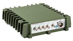
Caltrans — the California state agency responsible for highway, bridge and rail transportation planning, construction and maintenance — has taken delivery of the new Riegl VMX-1HA mobile mapping system.
The Riegl VMX-1HA dual-scanner mobile mapping system. Photo: Caltrans
The Riegl VMX-1HA is a high-speed, high-performance dual-scanner mobile mapping system. It provides high performance and dense, accurate and feature-rich data at highway speeds.
With two million measurements and five hundred scan lines per second, the turnkey solution is suited for survey-grade mobile mapping applications to meet the standards of departments of transportation nationwide, Riegl said.
The technology of the system comprises two Riegl VUX-1HA high-accuracy waveform lidar sensors and a high-performance INS/GNSS unit, housed in an aerodynamically shaped protective cover. Four 9-megapixel cameras, along with a LadyBug 5 camera, complement the waveform lidar data with precisely georeferenced images.
The Riegl software suite provides seamless workflows for mobile data acquisition, processing, adjustments and deliverables.
Riegl USA was awarded the contract of the Request For Quote (RFQ) on the open market.
Caltrans — the California state agency responsible for highway, bridge and rail transportation planning, construction and maintenance — has taken delivery of the new Riegl VMX-1HA mobile mapping system.
The Riegl VMX-1HA dual-scanner mobile mapping system.
The Riegl VMX-1HA is a high-speed, high-performance dual-scanner mobile mapping system. It provides high performance and dense, accurate and feature-rich data at highway speeds.
With two million measurements and five hundred scan lines per second, the turnkey solution is suited for survey-grade mobile mapping applications to meet the standards of departments of transportation nationwide, Riegl said.
The technology of the system comprises two Riegl VUX-1HA high-accuracy waveform lidar sensors and a high-performance INS/GNSS unit, housed in an aerodynamically shaped protective cover. Four 9-megapixel cameras, along with a LadyBug 5 camera, complement the waveform lidar data with precisely georeferenced images.
The Riegl software suite provides seamless workflows for mobile data acquisition, processing, adjustments and deliverables.
Riegl USA was awarded the contract of the Request For Quote (RFQ) on the open market.
Riegl‘s James Van Rens discusses the company’s airborne and UAV solutions at Intergeo 2016, which was held Oct. 11-13 in Hamburg, Germany. Riegl unveiled its VQ-1560i dual lidar channel airborne laser scanning system and miniVUX-1UAV lidar sensor.
Positioning and heading for mission-critical applications
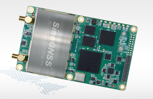
The K528G dual-frequency, multi-constellation GNSS board provides the highest accuracy in differential positioning. It benefits from numerous constellation signals because of its advanced tracking performance of both GPS and GLONASS. The K528G can provide positioning and heading information generated by two antennas. It is designed for guiding and positioning construction engines, dredges, barges, shipping container cranes, mining equipment and intelligent transportation systems.
Designed for small-cell and distributed antenna systems
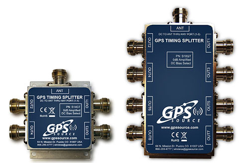
GPS Source has released of a line of GPS/GNSS splitters created for the small-cell wireless and distributed antenna system markets. Specifically designed for the L-band frequency, they can eliminate the cost of multiple antennas and long cable runs in wireless installations. With four or eight outputs, the new line of splitters make it possible to use a single GPS referencing antenna and cable arrangement for multiple synchronized systems. The splitters include features such as DC bias select and amplification. GPS Source RF signal splitters typically operate in conjunction with an active GPS antenna; consequently, a GPS RF signal splitter must have provisions for managing the DC voltage to the active GPS antenna. The S14GT and S18GT splitters will power an external GPS antenna from any of the RF outputs. A “hunt-and-pick” circuit is used to select only one DC input for power should more than one source be connected. Designed for redundancy, if the selected DC bias input should fail, the DC bias will automatically switch to another DC input to ensure an uninterrupted power supply to the active antenna.
For precision industrial, agricultural and military OEM applications
A new series of L1 band wideband antennas for OEM applications is offered in three formats:
▪ TW2106/TW2108 — GPS L1
▪ TW2406/TW2408 — GPS + GLONASS
▪ TW2706/TW2708 — Galileo, BeiDou, GPS + GLONASS
Each antenna type features Tallysman’s Accutenna technology, which provides high rejection of multipath signals, with low axial ratios and tight phase center variations (PCV). Each is available with a brickwall pre-filter option to protect against saturation by high level subharmonic and L-band signals. The antenna printed circuit boards (PCBs) are 56 millimeters in diameter with four plated holes for secure mounting. They are available with a variety of connectors and custom cable lengths, and can be custom-tuned. All of them are REACH and ROHS compliant.
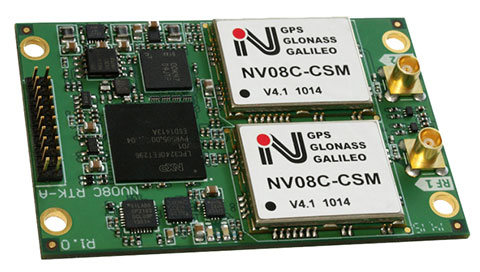
The NV08C-RTK-A is fully integrated multi-constellation L1 heading receiver with embedded real-tiime kinematic (RTK) functionality and compatibility with GPS, GLONASS, Galileo and BeiDou. The NV08C-RTK-A is designed for use in high-accuracy applications that demand low-cost, low-power consumption, a small form factor and high performance, such as construction, mining and industrial; environmental and structural monitoring; machine control; parallel driving systems; precision agriculture; UAVs; and robotics and intelligent machines.
The SLD-100 GNSS Rover accessory facilitates hydrographic measurement in bodies of water up to 100 meters in depth. it is designed for anyone who finds themselves needing to survey into bodies of water, streams and rivers. With survey-grade accuracy, the SLD-100 can be added to any brand GNSS RTK rover to allow for position and depth measurements to be made simultaneously. With a built-in 10-hour lithium battery and transmitter unit with Bluetooth connectivity, the SLD-100 provides standard-depth data streams in several industry-standard NMEA formats at 1 Hz, 4800 bps, providing compatibility with any hydrographic surveying software package. Position and depth information is externally logged on a computer or controller. Included transom mounting hardware enables easy installation.
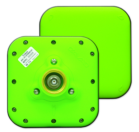
TriAnt is small, thin and rugged high-performance GNSS antenna. It measures 128 x 128 millimeters (mm) square and 39 mm thick. It can be mounted with three screws to flat surfaces. It is designed for applications such as machine control and surround anennas of the TRIUMPH-4X. The antenna cable is routed through the center of the antenna (TNC connector) for protection in harsh environments. The TriAnt can also be mounted on poles (1–14 inches thread) using its mount-pole attachment, which increases the thickness to 54.5 mm.
The X20i L1 GPS receiver by CHC Navigation is powered by a high-precision L1 GPS engine. Its integrated Bluetooth chip enables it to wirelessly collect submeter positions in real- time or centimeter post-processed on an iPhone or iPad. All location-aware apps on the iPhone and iPad are compatible with the X20i. Immediately after pairing and answering the security question allowing the X20i to take control of location services on the iOS device, 1 million iOS applications are capable of utilizing the high-accuracy data of the X20i, and become accurate to either 1 foot or 1 centimeter. Apps that can make use of the high accuracy include TerraGo Edge, ESRI’s ArcView Connector and those by CarteGraph Systems.
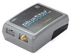
BlueStarGPS offers both GPS and GNSS options in a rugged, lightweight package. The BlueStarGPS device was designed to meet sub-meter mapping and data-collection needs in the pipeline and utility industries. It provides sub-meter precision without post-processing, and maintains accurate positioning when the SBAS signal is obstructed. This means it can function under trees, around buildings and in rugged terrain where other receivers can fail. The BlueStarGPS is designed specifically for use with Android mobile devices, such as smartphones, tablets or notebook computers, as well as cable and pipe “locating” tools with a connectivity range of up to 1 kilometer.
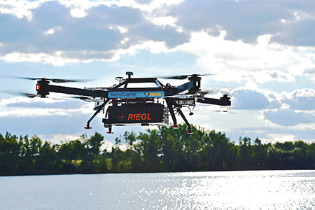
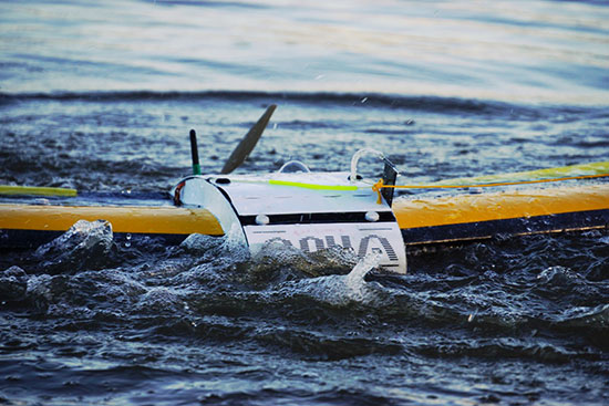
UAV measures through water surfaces of rivers, lakes
The RIEGL BathyCopter is a small-UAV-based surveying system capable of measuring through the water surface. It’s suitable for generating profiles of rivers or water reservoirs. The platform design integrates a topo-bathymetric green laser depth meter, an APX 15 inertial measurement unit (IMU)/GNSS with antenna, a control unit and a digital camera. Applications include generation of river profiles, survey of reservoirs and canals, landscaping, support of construction projects, and surveys for planning and carrying out hydraulic engineering work.
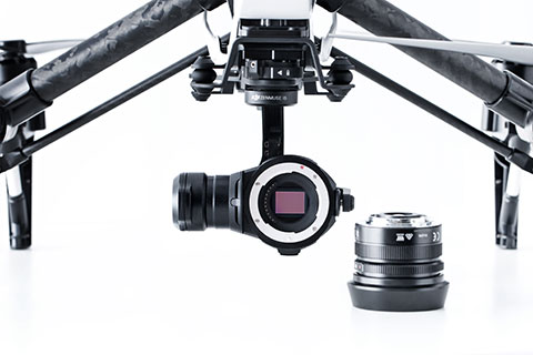
The Zenmuse X5 is a micro four-thirds (M4/3) camera designed specifically for aerial use. With a large sensor, aerial image makers will be able to capture up to 13 stops of dynamic range, enabling capture of high-resolution 16-megapixel photos or 4 k, 24 fps and 30 fps videos in complex lighting environments. It supports four interchangeable lenses. The Zenmuse X5 is designed for creation of high-quality aerial maps and 3D models, industrial and utility inspection, and professional video capture.
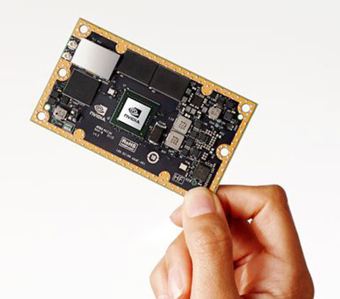
The NVIDIA Jetson TX1 module is designed to power smart devices — including drones that don’t just fly by remote control, but navigate their way through a forest for search and rescue. It is an embedded computer designed to learn to recognize objects or interpret information, incorporating capabilities such as machine learning, computer vision and navigation into a single system. This technology expands the ability of machines to operate on their own and adapt to their surroundings by recognizing images, processing conversational speech, or analyzing a room full of furniture and finding a path to navigate across it.
CEO Johannes Riegl unveils the new RIEGL BathyCopter at the Riegl INTERGEO booth in Stuttgart.
Following RIEGL‘s debut of the RiCOPTER at INTERGEO 2014, a fully integrated UAV-based lidar surveying solution, the company used INTERGEO 2015 in September to launch its new BathyCopter.
The BathyCopter is a small-UAV-based surveying system capable of measuring through the water surface. It’s suitable for generating profiles of rivers or water reservoirs. The platform design integrates a topo-bathymetric green laser depth-meter, an IMU/GNSS unit with antenna, a control unit and a digital camera. Applications include generation of river profiles, survey of reservoirs and canals, landscaping, support of construction projects, and surveys for planning and carrying out hydraulic engineering work.
Laser Scanner. RIEGL also offers the VQ-480-U laser scanner for UAVs, which provides high-speed data acquisition using a narrow infrared laser beam and a fast line scanning mechanism.
High-accuracy laser ranging is based on RIEGL’s echo digitization and online waveform processing, which provides measurement results even under adverse atmospheric conditions, the company said.
The Bramor RTK GNSS Post-Processing UAS is designed for surveying and remote-sensing applications that need a quick, high-precision set of results down to sub-centimeter level in the absence of a grid of ground control points. It is equipped with C-Astral high-rate GPS and IMU precision data-logging electronics. The system has both air and ground segments, consisting of a GNSS onboard receiver and ground base station. It has an L1 and L2 GNSS reciever (GPS, GLONASS, BeiDou and Galileo-ready), plus a survey-grade antenna.
The QuestUAV Aqua Pro is designed for offshore/onshore data-gathering in fields such as environmental, gas and oil, coast guard and security. It is a fixed-wing waterproof UAV based on the QuestUAV 200 airframe.
The Aqua Pro is capable of offshore missions and recovery in both fresh- and salt-water environments. It can withstand pressure differentials induced by rapid temperature changes, and overcome complexities of waterproofing/marine-grade electronics, sensors and avionics. It uses a GPS unit from SkyCircuits.
NovAtel’s GAJT-AE GPS anti-jam technology is designed for military and security weight- and size-constrained airborne and ground unmanned platforms, including UAVs. GAJT-AE provides the null forming antenna control electronics for a four-element controlled reception pattern antenna.
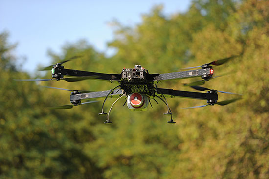
The Riegl RiCopter is an unmanned multirotor UAS, integrating a high-performance and complete LiDAR system, the RIEGL VUX-SYS. The VUX-SYS comprises the VUX-1 LiDAR sensor, the Applanix AP20 IMU/GNSS system, a control unit, and up to four high-resolution cameras.
The Riegl RiCopter can acquire high-accuracy, high-resolution laser scan and image data. The excellent measurement performance of the VUX-1 in combination with a precise fiber-optic gyroscope and GPS/GLONASS receiver results in survey-grade measurement accuracy in fields such as precision farming, forestry and mining. The IMU/GNSS unit provides roll and pitch accuracy of 0.015 degrees and heading accuracy of 0.035 degrees. Riegl is a maker of laser scanners, and using a high-end unmanned airborne platform allows data acquisition in dangerous and hard-to-reach areas.
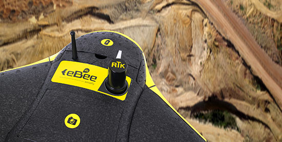
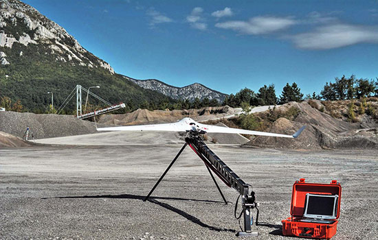
The eBee RTK by senseFly is a fully autonomous survey-grade mapping drone with a built-in L1/L2 GNSS receiver capable of receiving corrections from most leading brands of base station. This ensures high positional accuracy without the need for ground control points, so the aerial photography can produce orthomosaics and 3D models with accuracy down to 3 centimeters. It has 226 channels and tracks GPS L1, L2, L2C; GLONASS L1, L2, L2C; and SBAS.
At InterGeo 2014, James Van Rens, chief executive officer of Riegl, explains the launch of the RiCopter UAV with LiDAR integration, and its designer gives a live demonstration of the UAV in flight. The show was held October 7-9 in Berlin.
The unmanned aerial vehicle is a survey-grade unmanned scanning platform for a variety of demanding applications, such as corridor, power line, or railway mapping.
The high-performance UAV can be equipped with the Riegl VUX-1 survey-grade LiDAR sensor to offer a fully integrated turnkey solution. The RiCopter platform design includes a fully integrated Riegl VUX LiDAR sensor, IMU/ GNSS unit with antenna, control unit, and up to four optional cameras providing measuring characteristics of a 330-degree field of view, 500,000 measurements per second, and 10-millimeter accuracy.
The class 1 unmanned aircraft system can be flown at a maximum operating altitude of 550 meters with a maximum take-off mass of up to 25 kg and a maximum payload of 16 kg, providing a long flight endurance of 30 minutes.
RiCopter flight characteristics are smooth and stable in hovering positions, as well as on demanding flight maneuvers under challenging conditions.
Riegl Laser Measurement Systems and Applanix Corporation announced today that the Applanix AP50 GNSS-inertial sensor system was successfully integrated with Riegl’s VQ-820-GU topo-bathymetric airborne laser scanner on board the Schiebel Camcopter S-100 UAV. The Riegl VQ-820-GU is specifically designed to survey sea beds and the grounds of rivers or lakes, and is well suited for combined land and hydrographic airborne survey.
Applanix AP50 GNSS-inertial system.
The Applanix AP50 GNSS-inertial system is a GNSS-inertial sensor plus inertial measurement unit (IMU) in a compact form factor. It features a high-performance precision GNSS receiver and the Applanix IN-Fusion GNSS-inertial integration technology running on a powerful, dedicated inertial engine (IE) board.
On board an unmanned aerial vehicle (UAV), the system is capable of penetrating areas that may be too dangerous for piloted aircraft or ground patrols. This can provide additional safety and security for its users.
Riegl’s VQ-820-G airborne laser scanner.
“We really appreciate the professional and amicable cooperation with Applanix, which allows us to offer user-friendly and powerful, fully integrated solutions for dynamic data acquisition to the marketplace,” said Jürgen Nussbaum, Riegl director of international sales.
In addition, Applanix will be a Gold sponsor at Riegl LIDAR 2013, Riegl’s international user conference taking place in Vienna, Austria, June 25-27.